Drought Expected to Develop, Persist Across Many Pacific Northwest Tribal Lands This Summer
We’d love to hear from you! You are invited to join NIDIS and partners for a webinar on July 25, 2024 at 10 a.m. PT, which will include an update on conditions and an open discussion on your needs as they relate to drought management support.
Key Points
- A below-normal seasonal snowpack, combined with early snowmelt and recent dryness, have led to declining streamflows across large portions of the Pacific Northwest, and forecasts predict further declines. This raises concerns for inadequate water supplies across some areas of the Pacific Northwest this summer (Figures 1–2).
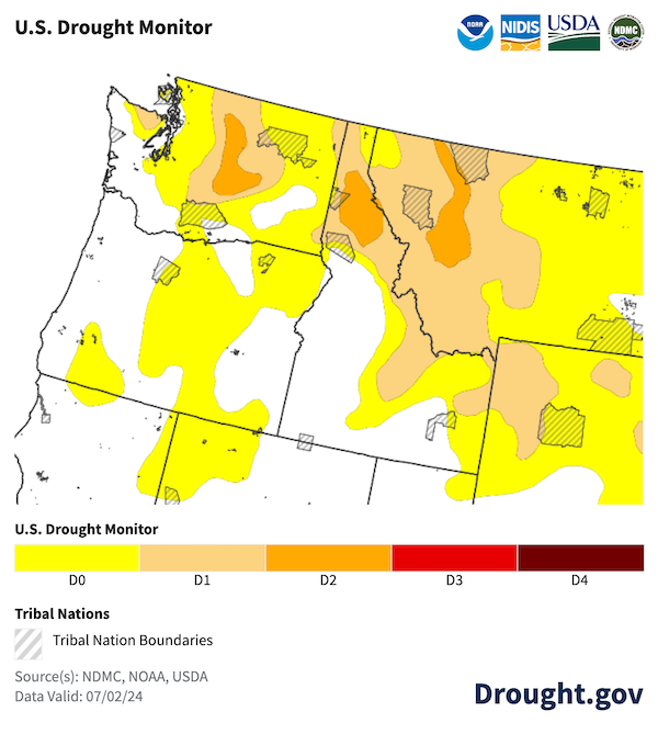
- Drought has already begun to develop and intensify across the region. According to the July 2 U.S. Drought Monitor, Abnormally Dry (D0) conditions and Moderate to Severe Drought (D1–D2) are present across the Pacific Northwest (Figure 3). In particular, nearly half of the tribal lands in the region are abnormally dry, and an additional 29.2% are in drought. Approximately 23% of the Coeur d’Alene Reservation is experiencing Severe Drought (D2).
- While spring temperatures were generally below normal across the Pacific Northwest, the very recent short-duration heat event in early July was the start of an expected shift to above-normal temperatures for the rest of the month. Heat advisories and excessive heat warnings are currently in effect throughout the region, and there is a slight risk for excessive heat to occur 1-2 weeks from now for inland areas of the Pacific Northwest.
- Forecasted above-normal temperatures and below-normal precipitation, particularly for inland regions of the Pacific Northwest, are expected to lead to drought development and further drought persistence in areas where drought is already present through the end of September (Figures 4–6).
- Above-normal wildland fire potential exists for tribal lands in northwestern Washington, central and southeastern Oregon, and southern Idaho from July–September, with tribal areas of northern and central Idaho expecting above-normal wildland fire potential in August and September (Figures 7–8). Wildland fire potential is expected to be normal for the entire Pacific Northwest in October.
Current Conditions
Figure 1. Pacific Northwest Peak Snow Water Equivalent (SWE) for Water Year 2024 as a Percent of the 1991–2020 Median
Key Takeaway: Below-normal water year peak snow water equivalent (SWE) across the region reflects the warm winter temperatures in the areas where drought is most widespread or severe. SWE in the Washington Cascades peaked at less than 50% of normal. Many stations also reflected SWE values at 50–70% of normal across the region.
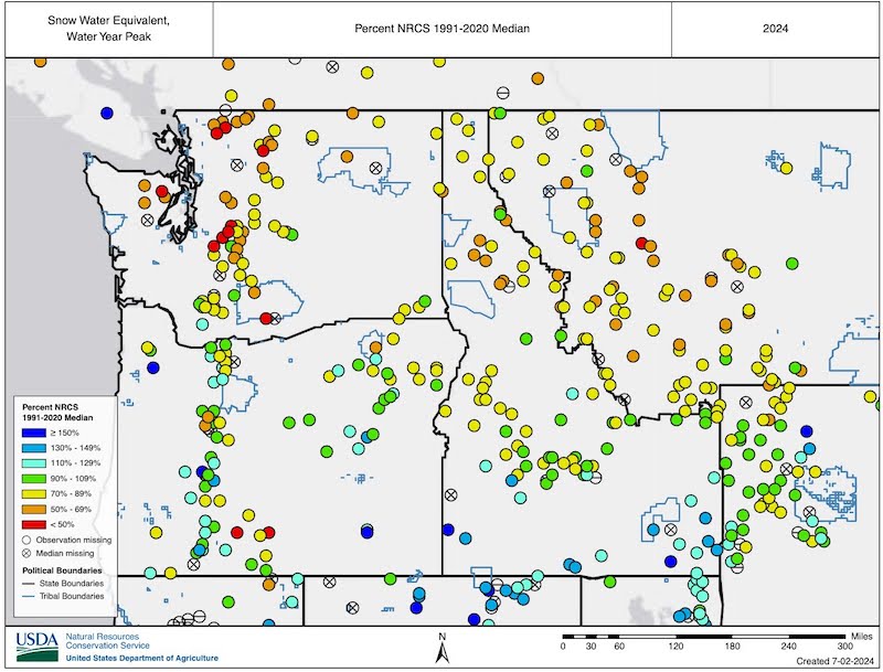
Figure 2. 28-Day Average Streamflow (July 8, 2024)
Key Takeaway: Over the past 28 days, streamflows across the Pacific Northwest ranged from near normal to much below normal, with below to much below-normal streamflow most common across inland areas of the region. This is due to the combination of a below-normal seasonal snowpack and early snowmelt as well as continued dryness in many areas throughout the spring and early summer.
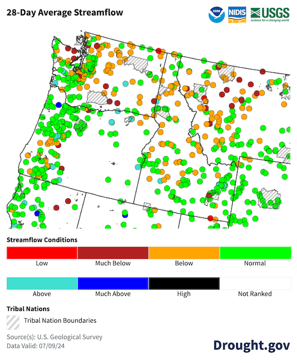
Figure 3. U.S. Drought Monitor for July 2, 2024
Key Takeaway: According to the July 2 U.S. Drought Monitor, nearly half of the tribal lands in the Pacific Northwest are Abnormally Dry (D0), and an additional 29.2% are in Moderate to Severe Drought (D1–D2).
Outlooks and Potential Drought Impacts
Potential Impacts for Summer 2024
- Dryland agriculture and pasture conditions are anticipated to deteriorate with above-normal temperatures. Hardships could include reduced water efficiency, lower stocking rates, and the need to haul water for livestock.
- Some river flows are projected to decline to levels at which fish will not be able to migrate later this summer, resulting in potential stranding and premature death of critical species. Tribal Nations and the U.S. Department of Fish and Wildlife are planning for low streamflows and taking proactive actions to respond early to these projected impacts. Fish hatchery operations are expected to be disrupted due to inadequate river flows.
- Impacts are also anticipated on small and more vulnerable public water systems requiring water trucking, well deepening, and rehabilitation to support domestic water uses.
Resources and Impact Reporting
- Would you like to report drought impacts or learn about impacts already reported? One way to do this is through the Condition Monitoring Observer Reports on Drought (CMOR-Drought) tool. The tool allows citizen scientists to submit observation reports relating to drought, which are presented in a map that can be used to view and access submitted information and attachments.
- The U.S. Department of Agriculture Farm Service Agency provides disaster assistance to producers across the country. This fact sheet describes the types of disaster designations and the process for declaring a disaster.
Figure 4. 3-Month Temperature Outlook for July 1–September 30, 2024
Key Takeaway: The Climate Prediction Center projects that temperatures are likely to be above normal from July–September 2024 for inland regions of the Pacific Northwest.
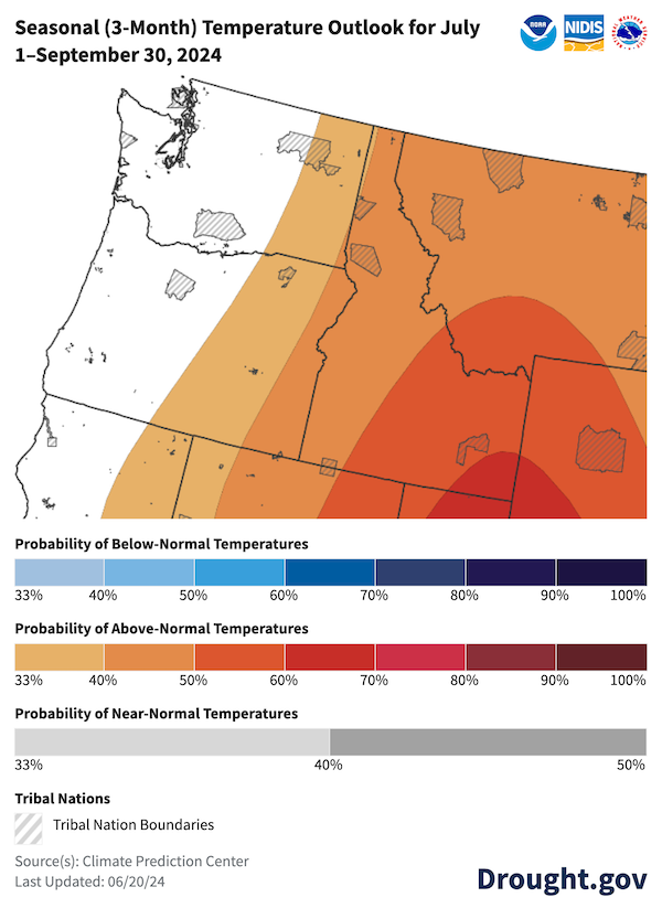
Figure 5. 3-Month Precipitation Outlook for July 1–September 30, 2024
Key Takeaway: The Climate Prediction Center projects that precipitation is likely to be below normal from July–September 2024 for inland regions of the Pacific Northwest.
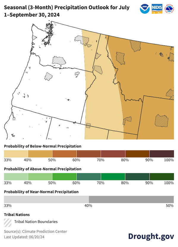
Figure 6. U.S. Seasonal (3-Month) Drought Outlook
Key Takeaway: The NOAA Climate Prediction Center’s U.S. Seasonal Drought Outlook (valid through September 30, 2024) indicates drought will persist in portions of western and central Washington, northern Idaho, and western Montana, with expansion of drought likely across a large portion of Washington, central and eastern Oregon, central and eastern Idaho, and northwestern Montana.
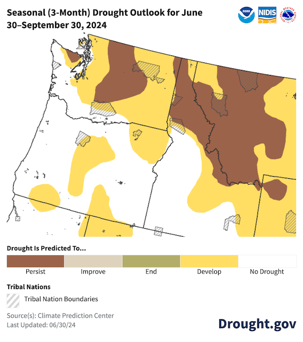
Figure 7. Significant Wildland Fire Potential Outlook for July 2024
Key Takeaway: The National Significant Wildland Fire Potential Outlook for July 2024 indicates that significant wildand fire potential will be above normal for tribal lands in northwestern Washington, central and eastern Oregon, and southern Idaho.
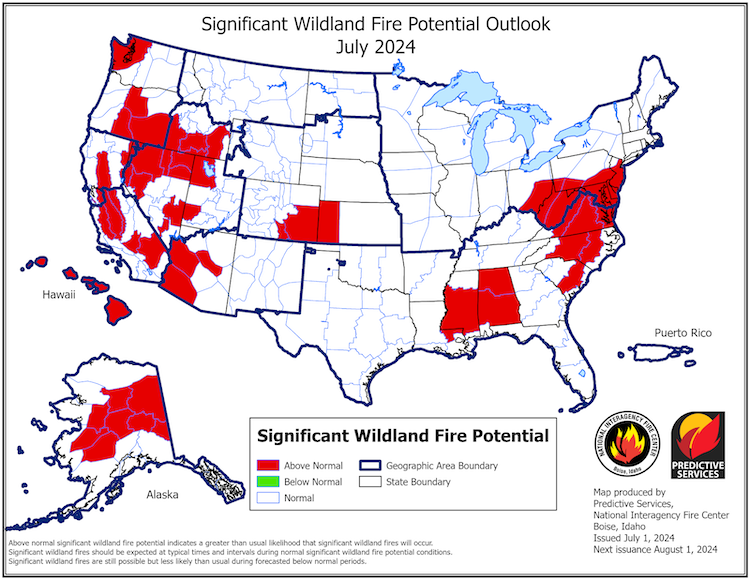
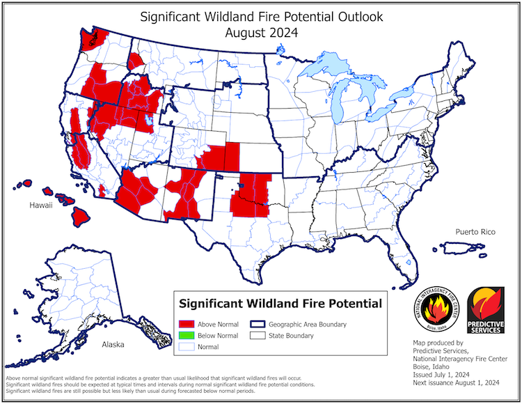
Figure 8. Significant Wildland Fire Potential Outlook for August 2024
Key Takeaway: The National Significant Wildland Fire Potential Outlook for August 2024 indicates that significant wildland fire potential will be above normal for tribal lands in northwestern Washington, central and eastern Oregon, and portions of northern, central, and southern Idaho.
Prepared By
Crystal Stiles, PhD; Jason Gerlich
Cooperative Institute for Research in Environmental Sciences (CIRES), NOAA’s National Integrated Drought Information System (NIDIS)
Kylie Avery; Patrick Freeland
Affiliated Tribes of Northwest Indians, Northwest Climate Adaptation Science Center
Amelia Marchand
Affiliated Tribes of Northwest Indians, Northwest Climate Adaptation Science Center, Northwest Climate Resilience Collaborative
Meade Krosby, PhD
Climate Impacts Group at the University of Washington, Northwest Climate Adaptation Science Center, Northwest Climate Resilience Collaborative
Holly Prendeville, PhD
USDA Northwest Climate Hub
Karin Bumbaco
Office of the Washington State Climatologist at the University of Washington
Matthew Laramie
Bureau of Indian Affairs Branch of Tribal Climate Resilience
James Rattling Leaf, Sr.
Wolakota Lab LLC
This Drought Status Update is issued in partnership by the National Oceanic and Atmospheric Administration (NOAA), the Northwest Climate Adaptation Science Center, the Affiliated Tribes of Northwest Indians, the Bureau of Indian Affairs Northwest Region, the Climate Impacts Group at the University of Washington, the Northwest Climate Resilience Collaborative, the Office of the Washington State Climatologist, and the U.S. Department of Agriculture Northwest Climate Hub to communicate potential areas of concern for drought expansion or development across tribal lands within the Pacific Northwest DEWS region on the basis of recent conditions and forecasts. NIDIS and its partners will issue future Drought Status Updates as conditions evolve.