From Ridge to Reef: New Tool Overcomes Hawai'i’s Climate Complexity to Improve Drought Monitoring
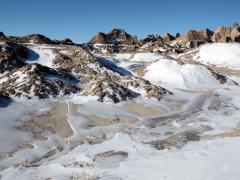
Hawai'i’s islands are mountainous, which drives steep climate gradients from reef to ridge on a single island. The topography of the largest islands and exposure to the northeast tradewinds creates cooler and wetter conditions on the North and East windward sides of the island and drier warmer conditions on the South and West (leeward sides of the islands). That diversity of climate types can make it difficult to monitor drought conditions.
Even in the Continental United States, where there’s a large network of stations and coarse data products available, such extreme variability is difficult to capture. Many of these data sets are not available or transferrable to Hawai’i. Existing drought monitoring products, such as the U.S. Drought Monitor, often have a coarse spatial resolution, making it difficult to track drought across Hawai'i’s peaks and valleys. To address these challenges, NIDIS-supported researchers from the Pacific Drought Knowledge Exchange (PDKE) developed an improved Standardized Precipitation Index (SPI), which captures how observed rainfall deviates from the climatological average over a given time period. This product uses high-resolution (250 meter) rainfall maps to produce the gridded SPI product in near-real-time on the Hawai'i Climate Data Portal (HCDP).
Drought Monitoring in a Complicated Climate
Hawai'i's tall mountains influence every aspect of its weather and climate. The mountains change the speed and direction of the flow of air. When warm, moist air rises over upwind coasts and slopes, clouds form and produce more rainfall over the land than over the open ocean. Areas on the downwind side, where the air descends, tend to be sunny and dry. The range in rainfall in Hawai'i is greater than the range across the entire U.S. Hawai'i, Maui, and Molokai contain areas of both rainforest (similar to southeast Florida) and hot, semi-arid climate (similar to south Texas). Kahoolawe, in the leeward shadow of Haleakala volcano on Maui, is hot and semi-arid year-round.
The Standardized Precipitation Index (SPI), is a drought index that captures how observed precipitation deviates from the climatological average over a given time period. This new SPI product integrates data from all available stations in Hawai'i, across a range of networks, including the Hawaii Mesonet, which is an ongoing effort to install 100+ state-of-the-art weather stations across Hawaii.
HCDP is a collaborative project with the Water Resources Research Center, Sea Grant College and the Information and Technology Services (ITS) at the University of Hawai‘i at Mānoa (UHM) designed to improve the availability and accessibility of climate data in Hawaii. With support from NOAA’s National Integrated Drought Information System (NIDIS), PDKE researchers are also developing a way to improve drought early warning to many stakeholders in Hawai'i. These products may support drought monitoring or be used to issue warnings to impacted sectors, but they can also raise awareness of drought across communities.
New Hawai’i SPI Improves Drought Early Warning
Drought can cause a range of impacts across sectors and ecosystems in Hawai’i. This includes reduced ground cover used to feed livestock and increasing erosion that can damage reefs. Drought can increase the risk of wildfire and harms habitats, water quality, endangered species, and other natural resources. Earlier warning of these impacts can allow communities to proactively plan and prepare for them.
HCDP’s drought maps have a number of potential drought monitoring and early warning uses. The interactive tool is detailed enough to allow water managers, emergency managers, fire departments, and agricultural producers to view SPI at their location of interest. The new tool may inform the U.S. Drought Monitor authors developing their weekly drought map.
The HCDP will also incorporate the data into other customizable decision support tools, such as the NIDIS-supported Hawai'i Rangeland Information Portal (H-RIP) and the Climate, Change, Climate Variability, and Drought Portfolio Tool. The National Weather Service Honolulu Weather Forecast Office plans on using the product to inform monthly weather summaries.

About HCDP’s SPI
The Standardized Precipitation Index (SPI) is a drought index based solely on historical rainfall data. It is calculated considering the probability of a given rainfall amount to long-term (30-year) precipitation records and standardizing the results. SPI values below -1 are typically classified as drought conditions. The lower the SPI value, the more severe the drought. Learn more about SPI interpretation.
Data analysts can calculate SPI over different time scales to reflect various types of drought. For example, 1-month is useful to assess short-term meteorological drought conditions, such as lack of rainfall, a 3-month SPI can be used to assess agriculture conditions such as lack of soil moisture. A 12-month SPI is better suited to detect long-term droughts and impacts to stream hydrology. 24-month SPI provides insight into global climate patterns that influence seasonal climate, such as the Pacific Decadal Oscillation (PDO).
The HCDP product uses high-resolution (250 m) rainfall maps (see Long-Term, Gridded Standardized Precipitation Index for Hawai‘i) to produce a gridded SPI product in near-real-time. These maps are produced monthly on the first day of the month. SPI is calculated based on a base period from 1991 to 2020. SPI is computed for 1, 3, 6, 9, 12, 24, 36, 48, and 60-month time scales. Data is available from 1990 to the most recent month.
Use the Tool
View monthly SPI maps for Hawai'i at multiple monthly timesteps using the HCDP’s interactive map viewer. You can also customize the map’s base layers or color scheme—the authors suggest using a “diverging” color scheme to examine drought/no drought conditions. Click anywhere on the map or visit the time series tab to create a graph of SPI conditions over time. You can click “download time series” above the graph to download the time series data.