New NOAA El Niño-Southern Oscillation Index Supports Drought Early Warning
The Oceanic Niño Index (ONI) has traditionally been NOAA's official measure, or index, to track the El Niño-Southern Oscillation (ENSO). The ONI is calculated as the rolling 3-month average sea surface temperature departure from average (anomaly) in the east-central tropical Pacific Ocean. The warmer-than-average phase of ENSO is called El Niño, the cooler-than-average phase is called La Niña, and near-average is called ENSO-neutral.
In February 2026 NOAA’s Climate Prediction Center adopted the Relative Oceanic Niño Index (RONI) to better characterize the past, present and future of ENSO. RONI accounts for the long-term ocean temperature trends in a way that the traditional ONI does not, thus providing a better representation of the seasonal climate variability. As a result, in most cases, RONI will dampen the strength of El Niños and amplify La Niñas when compared to the traditional ONI.
RONI and Drought in the Southern Tier of the U.S.
ENSO is a slowly-changing aspect of earth system variability that affects global weather, including across the United States. We often look to ENSO to give an indication of which weather patterns are most likely to be prominent during a season over a given region.
ENSO is often used to guide drought forecasts during parts of the year and in regions of the United States when and where it has a stronger influence. Generally, the stronger the ENSO event, the more likely the expected atmospheric response is, meaning there is greater confidence in the forecasts based on ENSO’s influence. This is why the shift to the RONI becomes really important. Not accounting for the warming oceans means recent El Niño temperature anomalies look bigger than they really are, and La Niña anomalies look smaller. La Niña usually, but not always, coincides with warm, dry winters across the southern tier of the United States. Because it can drive or exacerbate drought in the region, an accurate picture of ENSO’s strength is important to understand and predict drought.
Consider the last six winters: Five of the last six winters saw a La Niña pattern, which is one of the reasons much of the southern half of the Nation experienced persistent and recurring drought throughout the first half of this decade. Using the traditional ONI, 2020-2023 experienced a “triple-dip” La Niña, but RONI classified this as one continuous, unbroken La Niña event that lasted three years. These years were also very dry across the Southwest and Southern Plains.
In more recent years, the RONI identifies some ENSO events differently than the ONI, establishing designations more in line with the observed impacts on weather patterns across the U.S. The 2023-2024 El Niño was still an El Niño, but RONI measured it slightly weaker than the traditional ONI (0.6 ºCelsius cooler, in fact). The 2024-2025 and 2025-2026 winters were ENSO-neutral using the traditional ONI. Using RONI, these events would instead be classified as definitive La Niñas.
Winter 2025-2026 brought Moderate to Severe Drought (D1-D2) or worse for a broad swath of the Southern U.S. from Arizona to Florida. The La Niña pattern in place since around August 2025 is a primary driver of this drought. This season mostly followed the traditional La Niña response, with a few exceptions: near-average conditions in southern California (instead of drier) and a very dry pattern along the southern Ohio River Valley (instead of wet). As La Niña transitions into an ENSO-neutral phase this spring, we also hope regular rainfall will return across the south. As we look ahead to next fall and winter, we are already asking “what’s next?”

Is El Niño on the Horizon?
El Niño is probably what’s next, but there are some things to keep in mind as we look at the climate pattern for the year ahead.
Pacific Ocean temperature measurements hint at a pattern shift. Over the past month, Pacific Ocean temperatures beneath the surface became increasingly warmer than normal, which is consistent with the potential development of El Niño later this year.
In a typical year, easterly trade winds drag the surface layer of warm water away from South America, leading to colder water from deep in the ocean to rise to the surface (upwelling). During a developing El Niño, these trade winds weaken, upwelling slows, and this allows warmer-than-normal water to build up in the east Pacific along the equator. That's what is happening right now.
If the atmosphere responds to the warming ocean surface temperatures—and rising air in the tropics follows the warmer water, shifting eastward—then the surface trade winds will further weaken. That could cause the above-average sea surface temperatures to expand across the central and east-central Pacific Ocean. If this feedback loop becomes fully established, persists, and meets set criteria,1 then El Niño is declared. If the atmosphere does not reinforce the ocean temperature patterns, this warmer water will dissipate, and ENSO-neutral becomes more likely. In other words, we currently see the beginning of a possible El Niño, but we need to wait a bit longer to see how it will develop.

In addition to the observed changes in the ocean and atmosphere, physical and statistical forecast models also create predictions of what might happen in the Pacific Ocean in the season and year ahead. Each model creates a slightly different, yet physically possible outcome. When multiple different models—or multiple runs from the same model—all tell the same story, we have higher confidence that the forecast will likely happen. When the models tell different stories, we are less certain.
Right now, about 80% of the models cross the El Niño threshold by early fall. Just under 20% of the models remain ENSO-neutral, and a very small minority of the forecasts show a weak La Niña pattern.
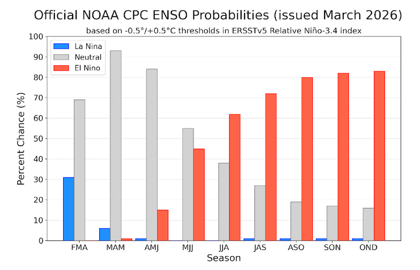
These modeled scenarios give us confidence that another La Niña pattern is not likely (but not impossible) and that an El Niño pattern is most likely (but not guaranteed). One other thing to keep in mind is that spring time is when the sea surface patterns across the tropical Pacific Ocean are in their transition phase. From a forecast perspective, this creates a springtime predictability barrier. We should not be surprised if the forecasts change as we go into the summer months.
The impacts of ENSO on weather patterns are nuanced, change by season and location, and are not guaranteed. Typical El Niño weather patterns would bring needed improvement to drought conditions across the southern tier of the U.S. Each season is different, and typical El Niño weather patterns don’t always happen. Different climate drivers interact to influence weather patterns across the country in complex ways. If El Niño develops, which it might not, RONI will provide a more realistic expectation of how strong the event will be and the possible impact on precipitation across the country, compared to the traditional ONI.
Thank you to Michelle L'Heureux (NOAA's National Weather Service Climate Prediction Center) and Andrew Hoell (NOAA's Physical Sciences Laboratory), who reviewed this story.
1. The exact criteria used to declare an El Niño or a La Niña varies by country and national meteorological organization.