Rain relief: How long will it last?
For more details, see the Northeast Drought Early Warning System Dashboard.
Key Points
- Moderate Drought (D1) was reduced to a few small areas in northern New York and in the Connecticut River Valley in New Hampshire and Vermont.
- Abnormally Dry conditions (D0) formed a patchwork pattern across the region. Only the southernmost New England states of Connecticut and Rhode Island were free of dryness.
- Some locations in the region have seen very little springtime snow. Boston, Concord, and Portland have recorded less than an inch since March 1.
Current U.S. Drought Monitor map for the Northeast Drought Early Warning System (DEWS) with data valid for May 11, 2021. The U.S. Drought Monitor is updated each Thursday to show the location and intensity of drought across the country.
According to the latest U.S. Drought Monitor:
- Moderate drought (D1) conditions exist in 3.7% of the region.
- Abnormally dry (D0) conditions exist in 31.4% of the region.
U.S. Drought Monitor Categories
Current U.S. Drought Monitor map for the Northeast Drought Early Warning System (DEWS) with data valid for May 11, 2021. The U.S. Drought Monitor is updated each Thursday to show the location and intensity of drought across the country.
According to the latest U.S. Drought Monitor:
- Moderate drought (D1) conditions exist in 3.7% of the region.
- Abnormally dry (D0) conditions exist in 31.4% of the region.
Current Conditions
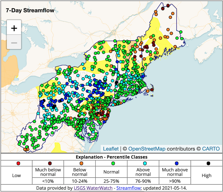
7-Day Average Streamflows
Streamflows are above average for most of the Northeast except for Maine and northern Vermont.
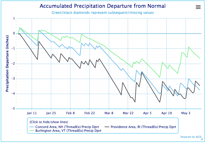
Annual Precipitation Departure from Normal
Much of the Northeast was experiencing a downward trend of precipitation departure in 2021 that has somewhat moderated in the last few weeks.
State-Reported Impacts
Rhode Island
- As of Thursday, May 13th, the Scituate Rhode Island Reservoir was just over 105% capacity.
- Currently, USGS Groundwater monitoring wells in the state were normal to just above normal.
Sign Up for Local Drought Alerts
Get an email notification when the U.S. Drought Monitor category changes for your location.
Outlooks
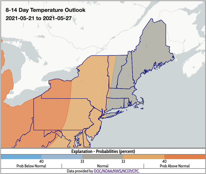
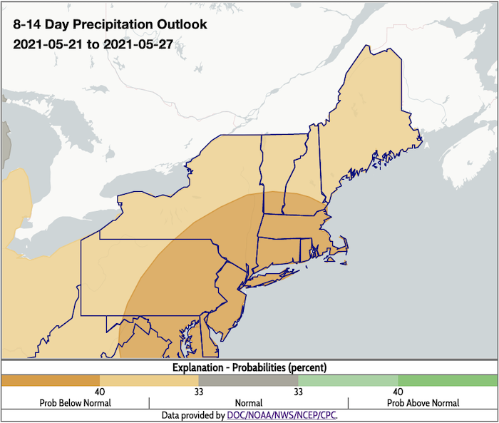
- The 8-14 day maps indicate above-normal temperatures for New York into western Vermont, Massachusetts, and Connecticut and normal temperatures for the rest of the region. Below-normal precipitation is predicted for the entire Northeast.
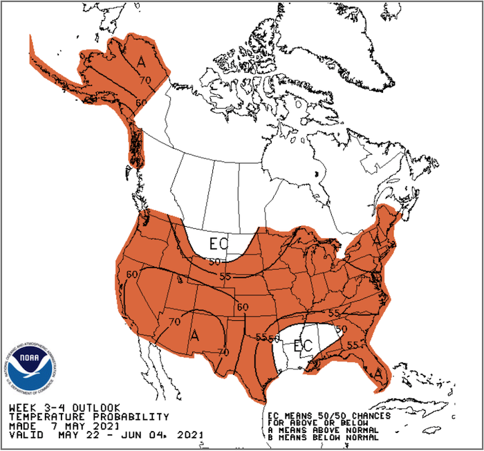
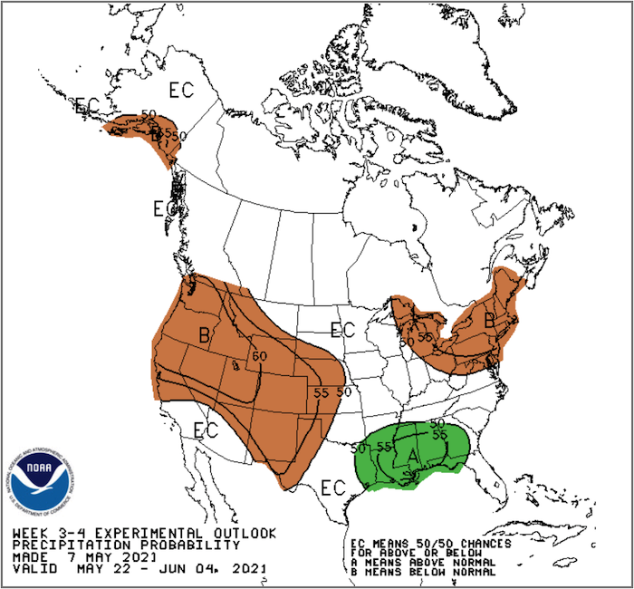
- The 3-4 week outlook favors above-normal temperatures and below-normal precipitation in the Northeast.
8-14 Day Temperature Outlook
8-14 Day Precipitation Outlook
3-4 Week Temperature Outlook
3-4 Week Precipitation Outlook
Additional Resources
- Northeast DEWS Dashboard
- NOAA Regional Climate Services
- Your local National Weather Service office
- NOAA Regional Climate Services Monthly Webinar Series (next webinar is on May 27)
- USDA Northeast Climate Hub
- USGS New England and New York Water Science Centers
Contacts for More Information
Sylvia Reeves
Regional Drought Information Coordinator (Northeast DEWS)
NOAA/CIRES/National Integrated Drought Information System (NIDIS)
Email: sylvia.reeves@noaa.gov
Ellen L. Mecray
Regional Climate Services Director, Eastern Region
NOAA/NESDIS/National Centers for Environmental Information
Email: Ellen.L.Mecray@noaa.gov
Prepared By
Sylvia Reeves
NOAA/National Integrated Drought Information System (NIDIS)
Samantha Borisoff, Jessica Spaccio, Keith Eggleston, Art DeGaetano
Northeast Regional Climate Center
Ellen Mecray
Regional Climate Services Director, Eastern Region, NOAA
David Hollinger and Maria Janowiak
USDA Climate Hubs
Gardner Bent
USGS/New England Water Science Center
In partnership with National Weather Service Offices of the Northeast and State Climate Offices of the Northeast.
This drought early warning update is issued in partnership between the National Oceanic and Atmospheric Administration (NOAA), U.S. Geological Survey, and the U.S. Department of Agriculture (USDA) to communicate concern for drought expansion and intensification within the Northeast U.S. based on recent conditions and the forecasts and outlooks. NIDIS and its partners will issue future drought early warning updates as conditions evolve.
