Short-Term Drought Improvements in the Midwest, but Long-Term Deficits Remain—Leading to Increased Vulnerability to Drought
Key Points
- According to the U.S. Drought Monitor, 23% of the Midwest region is in drought. Iowa has the greatest extent of drought (58% of the state), and other areas currently in drought include northern Minnesota, portions of Wisconsin and Missouri, the Upper Peninsula of Michigan, southern Illinois, and western Kentucky.
- While much of the region is not currently in drought, significant portions of the region, including Iowa and portions of Minnesota, Wisconsin, Missouri, and Indiana, have long-term precipitation deficits over the last four years of at least 22 inches, with some areas in Iowa over 33 inches.
- Hydrology is showing the impacts of drought and the long-term dryness, including soil moisture, streamflow, and groundwater. Soil moisture, particularly subsoil moisture, and streamflow are below normal in Iowa, Missouri, and Minnesota. Groundwater levels have been trending downward in some states, including Iowa, Minnesota, Missouri, Indiana, Illinois, and Kentucky.
- Summer outlooks call for greater chances for above-normal temperatures across a majority of the Midwest, and a greater chance for above-normal precipitation across portions of the Ohio River Basin. All other portions of the Midwest have equal chances for above-, near-, or below-normal precipitation.
- While there have been short-term improvements in drought conditions and current impacts at the surface in many areas are minimal, the longer-term precipitation deficits are contributing to an increased vulnerability to drought in the Midwest. This underlying dryness throughout the region means that locations are very reliant upon regular spring and summer precipitation to avoid worsening drought conditions.
- While the Mississippi River has rebounded from the low levels experienced last fall, the river has increased vulnerability to drought this summer and fall due to the lack of snowfall and the overall long-term precipitation deficits throughout the region.
- If the current wetter pattern continues and the region receives regular and frequent precipitation, drought conditions will likely improve in some areas. However, for areas that receive below-normal precipitation in the coming months, these areas may be at risk for worsening drought conditions due to increased evaporative demand from higher temperatures and a lack of subsoil moisture.
The U.S. Drought Monitor depicts the location and intensity of drought across the country. The map uses 5 classifications: Abnormally Dry (D0), showing areas that may be going into or are coming out of drought, and four levels of drought (D1–D4).
The U.S. Drought Monitor is a joint effort of the National Oceanic and Atmospheric Administration, U.S. Department of Agriculture, and National Drought Mitigation Center.
A drought index combines multiple drought indicators (e.g., precipitation, temperature, soil moisture) to depict drought conditions. For some products, like the U.S. Drought Monitor, authors combine their analysis of drought indicators with input from local observers. Other drought indices, like the Standardized Precipitation Index (SPI), use an objective calculation to describe the severity, location, timing, and/or duration of drought.
Learn MorePeriods of drought can lead to inadequate water supply, threatening the health, safety, and welfare of communities. Streamflow, groundwater, reservoir, and snowpack data are key to monitoring and forecasting water supply.
Learn MoreDrought can reduce the water availability and water quality necessary for productive farms, ranches, and grazing lands, resulting in significant negative direct and indirect economic impacts to the agricultural sector. Monitoring agricultural drought typically focuses on examining levels of precipitation, evaporative demand, soil moisture, and surface/groundwater quantity and quality.
Learn MoreU.S. Drought Monitor Categories
Abnormally Dry (D0)
Abnormally Dry (D0) indicates a region that is going into or coming out of drought. View typical impacts by state.
Moderate Drought (D1)
Moderate Drought (D1) is the first of four drought categories (D1–D4), according to the U.S. Drought Monitor. View typical impacts by state.
Severe Drought (D2)
Severe Drought (D2) is the second of four drought categories (D1–D4), according to the U.S. Drought Monitor. View typical impacts by state.
Extreme Drought (D3)
Extreme Drought (D3) is the third of four drought categories (D1–D4), according to the U.S. Drought Monitor. View typical impacts by state.
Exceptional Drought (D4)
Exceptional Drought (D4) is the most intense drought category, according to the U.S. Drought Monitor. View typical impacts by state.
The U.S. Drought Monitor depicts the location and intensity of drought across the country. The map uses 5 classifications: Abnormally Dry (D0), showing areas that may be going into or are coming out of drought, and four levels of drought (D1–D4).
The U.S. Drought Monitor is a joint effort of the National Oceanic and Atmospheric Administration, U.S. Department of Agriculture, and National Drought Mitigation Center.
This map is released every Thursday morning, with data valid through Tuesday at 7 a.m. ET.
A drought index combines multiple drought indicators (e.g., precipitation, temperature, soil moisture) to depict drought conditions. For some products, like the U.S. Drought Monitor, authors combine their analysis of drought indicators with input from local observers. Other drought indices, like the Standardized Precipitation Index (SPI), use an objective calculation to describe the severity, location, timing, and/or duration of drought.
Learn MorePeriods of drought can lead to inadequate water supply, threatening the health, safety, and welfare of communities. Streamflow, groundwater, reservoir, and snowpack data are key to monitoring and forecasting water supply.
Learn MoreDrought can reduce the water availability and water quality necessary for productive farms, ranches, and grazing lands, resulting in significant negative direct and indirect economic impacts to the agricultural sector. Monitoring agricultural drought typically focuses on examining levels of precipitation, evaporative demand, soil moisture, and surface/groundwater quantity and quality.
Learn MoreCurrent Conditions for the Midwest
- According to the U.S. Drought Monitor, 23% of the Midwest region is in drought. Iowa has the greatest extent of drought with 31% of the state in Moderate Drought (D1), 24% in Severe Drought (D2), and 3% in Extreme Drought (D3). Other areas in drought include northern Minnesota, portions of Wisconsin and Missouri, the Upper Peninsula of Michigan, southern Illinois, and western Kentucky.
- Drought conditions improved in many areas of the Midwest over the winter season (Figure 1) due to near- to above-normal precipitation across much of the Midwest (Figure 2).
- One major thing that was missing from much of the Midwest winter was snowfall, particularly across the Upper Midwest (Figure 3). Some portions of the Upper Peninsula of Michigan saw snowfall deficits of 80 inches or more. In Minnesota, deficits were anywhere from 20 to 50 inches. The lack of snow caused significant economic impacts for recreation and tourism in the Upper Midwest. Also, less snowfall means less replenishment of streamflow, soil moisture, and groundwater, which typically happens during the snowmelt season in late winter and spring.
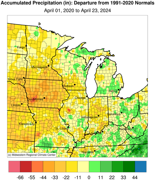
- One issue to note are the long-term precipitation deficits that are affecting portions of the Midwest region. Figure 4 shows the 4-year precipitation deficits for the region. There are significant portions of the Midwest, including Iowa and portions of Minnesota, Wisconsin, Missouri, and Indiana, that have precipitation deficits of over 22 inches. In western Iowa, some areas are 33 to 55 inches below normal over the last four years.
- While there have been short-term improvements in drought conditions and impacts at the surface are minimal in many areas, the longer-term precipitation deficits increase the overall vulnerability of the region. This underlying dryness throughout the region due to longer-term deficits means that locations are very reliant upon regular spring and summer precipitation to avoid worsening drought conditions.
Figure 1: 13-Week U.S. Drought Monitor Change Map (Since January 23, 2024)
Key Takeaway: Drought conditions have improved in many areas of the Midwest over the last 13 weeks, according to the U.S. Drought Monitor. However, drought worsened in portions of Missouri, Minnesota, Wisconsin, Michigan, and southern Illinois by at least one category.
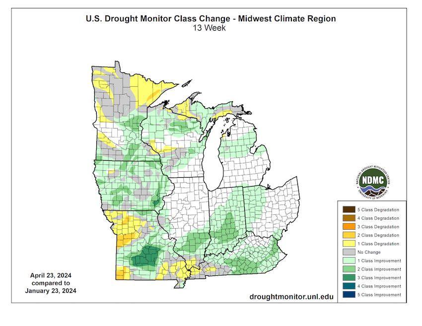
Figure 2: Percent of Normal Precipitation Since December 1, 2023
Key Takeaway: Much of the Midwest saw near- to above-normal precipitation over the winter season, anywhere from 75%–200% of normal.
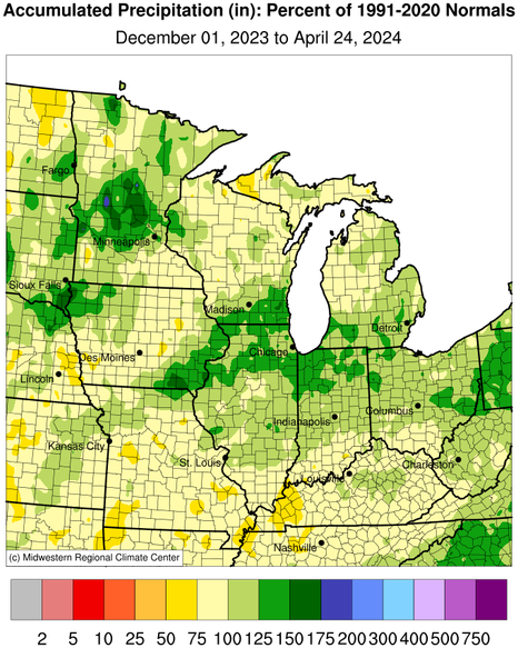
Figure 3: Departure from Normal Snowfall Since October 1, 2023
Key Takeaway: Snowfall was below normal across a majority of the Midwest, particularly across the Upper Midwest. The Upper Peninsula of Michigan had snowfall deficits of over 80 inches in some areas.
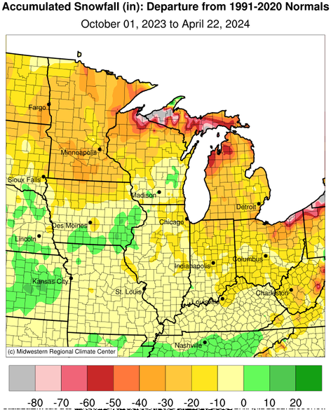
Figure 4: Four-Year Departure from Normal Precipitation (since April 1, 2020)
Key Takeaway: Long-term precipitation departures are significant across the Midwest. Since April 2020, some areas, including Iowa and portions of Minnesota, Wisconsin, Missouri, and Indiana, have precipitation deficits of over 22 inches.
Midwest Drought Impacts
- Soil moisture, particularly subsoil moisture, is low across western portions of the Midwest (Figure 5). In Iowa, 55% of subsoil moisture is reported to be short to very short according to USDA-NASS. Minnesota and Missouri are reporting 41% and 46% short to very short, respectively.
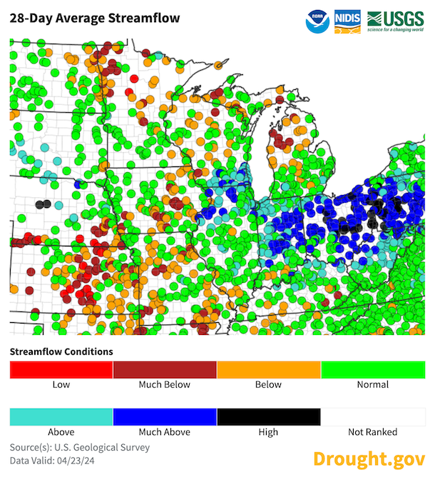
- Hydrology is showing the impacts of drought and long-term dryness, including both streamflow and groundwater. Streamflow is below normal across much of Missouri, Michigan, Wisconsin, Minnesota, Iowa, and portions of Kentucky (Figure 6). At the headwaters in Minnesota, the Mississippi River is lower than normal for this time of year.
- Several states across the Midwest (Iowa, Minnesota, Missouri, Indiana, Illinois, Kentucky) have reported that groundwater is not rebounding as expected in recent years. This has led to an overall concern that groundwater availability may be lessening across the region.
- The Mississippi River has rebounded from the low levels experienced last fall. Navigation and commerce along the river have returned to normal. However, the river above the confluence with the Ohio River is still running below average for this time of year.
- Water supply issues are a concern in portions of Iowa due to low surface water and groundwater. Some water suppliers implemented voluntary and mandatory restrictions over the winter, which is unusual at this time of year. Water supply issues are likely compounding in the state after multiple years of drought, and there is concern these issues may be exacerbated as water demand increases in the summer months.
- The lack of snow caused significant economic impacts for recreation and tourism in the Upper Midwest. In Michigan, small businesses impacted by the lack of snow were urged to apply for economic disaster loans from the federal government by Governor Whitmer of Michigan.
- Minnesota, Wisconsin, and Michigan have experienced more fires than normal for this time of year, and burn bans have been issued in these areas as well as in Indiana.
Figure 5: Subsoil Moisture - Percent Short to Very Short (week ending April 21, 2024)
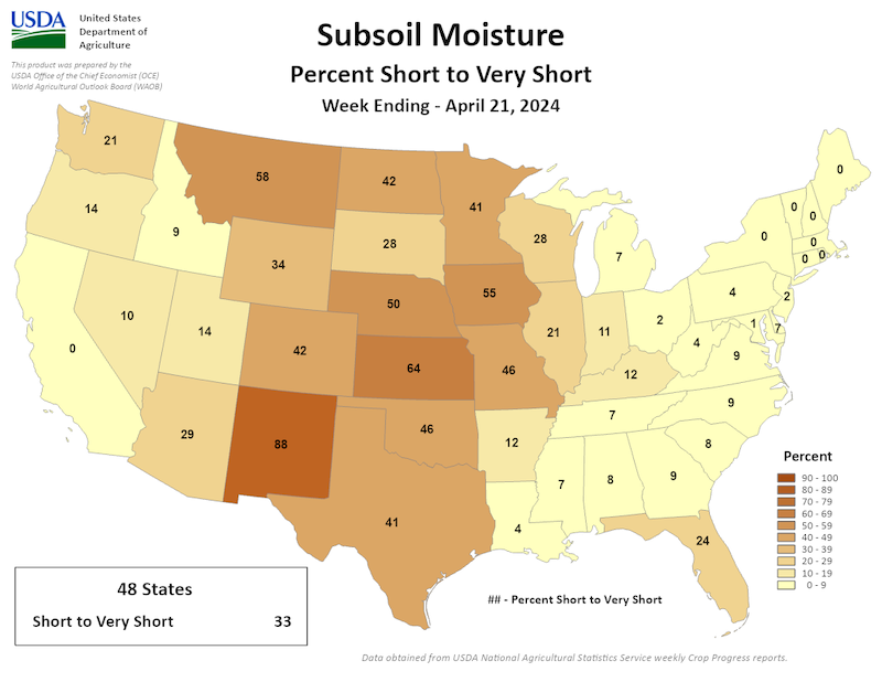
Figure 6: 28-Day Average Streamflow Conditions (Valid April 23, 2024)
Key Takeaway: Streamflow averaged over the last 28 days has been below normal in areas across the Midwest, including portions of Missouri, Iowa, Minnesota, Michigan, Kentucky, and Wisconsin.
Report your local drought impacts through a Condition Monitoring Observer Report:
Outlooks and Potential Impacts
- The temperature outlook for May 2024 shows a greater chance for above-normal temperatures to continue across the Midwest, particularly over the Great Lakes region (Figure 7). Precipitation may also be above normal in the lower Midwest (Missouri, western Iowa, Kentucky, southern Illinois, southern Indiana, and southern Ohio). In other places, there are equal chances for above-, near-, or below-normal precipitation.
- Looking further ahead to the summer (May–July 2024), temperatures are likely to be above normal throughout this period for most of the Midwest (with the exception of far northwest Minnesota).
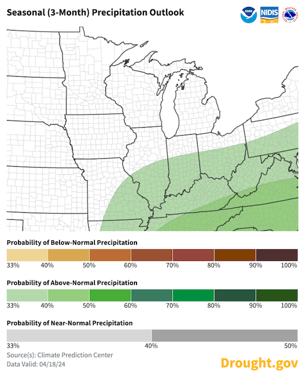
- Summer precipitation (May–July 2024) has a greater chance of being above normal across portions of the Ohio River Basin (Figure 8). Other portions of the Midwest, including Iowa, Minnesota, and Wisconsin, have equal chances for above-, near-, or below-normal precipitation.
- If the current wetter pattern continues and the region receives consistent and frequent precipitation, drought conditions will likely improve in some areas.
- However, with above-normal temperatures forecast for May through July, areas that receive below-normal precipitation may be at risk for worsening drought conditions due to increased evaporative demand and a lack of subsoil moisture. If temperatures increase quickly and it becomes dry, it is possible that the region could see drought conditions worsen rapidly.
- The Mississippi River also has increased vulnerability to drought this summer and fall due to the lack of snowfall and the overall long-term precipitation deficits throughout the region.
Figure 7: May 2024 Temperature Outlook
Key Takeaway: Widespread above-normal temperatures are expected in May 2024 across the Midwest region.
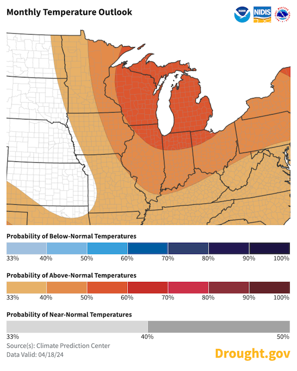
Figure 8: Summer (May–June–July) Precipitation Outlook
Key Takeaway: The summer precipitation outlook calls for greater chances of above-normal precipitation across southern portions of the Midwest and equal chances for above-, near-, or below-normal precipitation elsewhere.
Resources
For More Information
- More local information is available from the following resources:
- To report or view local drought impact information:
- Register for the North Central U.S. Climate and Drought Summary & Outlook Webinar on Thursday, May 16 at 1 p.m. CT, which will provide updated information about conditions, impacts, and outlooks.
Prepared By
Molly Woloszyn
Cooperative Institute for Research in Environmental Sciences (CIRES), University of Colorado Boulder
NOAA National Integrated Drought Information System (NIDIS)
Doug Kluck
NOAA National Centers for Environmental Information
Dennis Todey & Laura Nowatske
USDA Midwest Climate Hub
Audra Bruschi
NOAA/National Weather Service Central Region
Jim Noel & Mike Welavert
NOAA/National Weather Service/Ohio and North Central River Forecast Center
Anna Wolverton
U.S. Army Corps of Engineers Mississippi Valley Division/NOAA National Weather Service
Melissa Widhalm
Midwestern Regional Climate Center/Purdue University
Denise Gutzmer
National Drought Mitigation Center
This drought status update is issued in partnership between the National Oceanic and Atmospheric Administration (NOAA) and the U.S. Department of Agriculture (USDA) to communicate a potential area of concern for drought expansion and/or development within the Midwest based on recent conditions and the upcoming forecast. NIDIS and its partners will issue future drought status updates as conditions evolve.


