Abnormally dry (D0) conditions drop to less than 2% coverage in the region. The lack of snow is still a concern.
Key Points:
- On the U.S. Drought Monitor, abnormally dry (D0) conditions remain only in small portions of central New York (just south of Lake Ontario) and across the eastern two-thirds of Long Island.
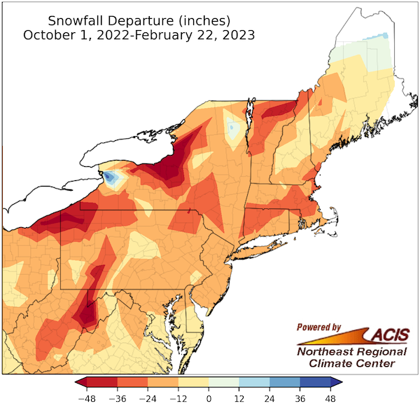
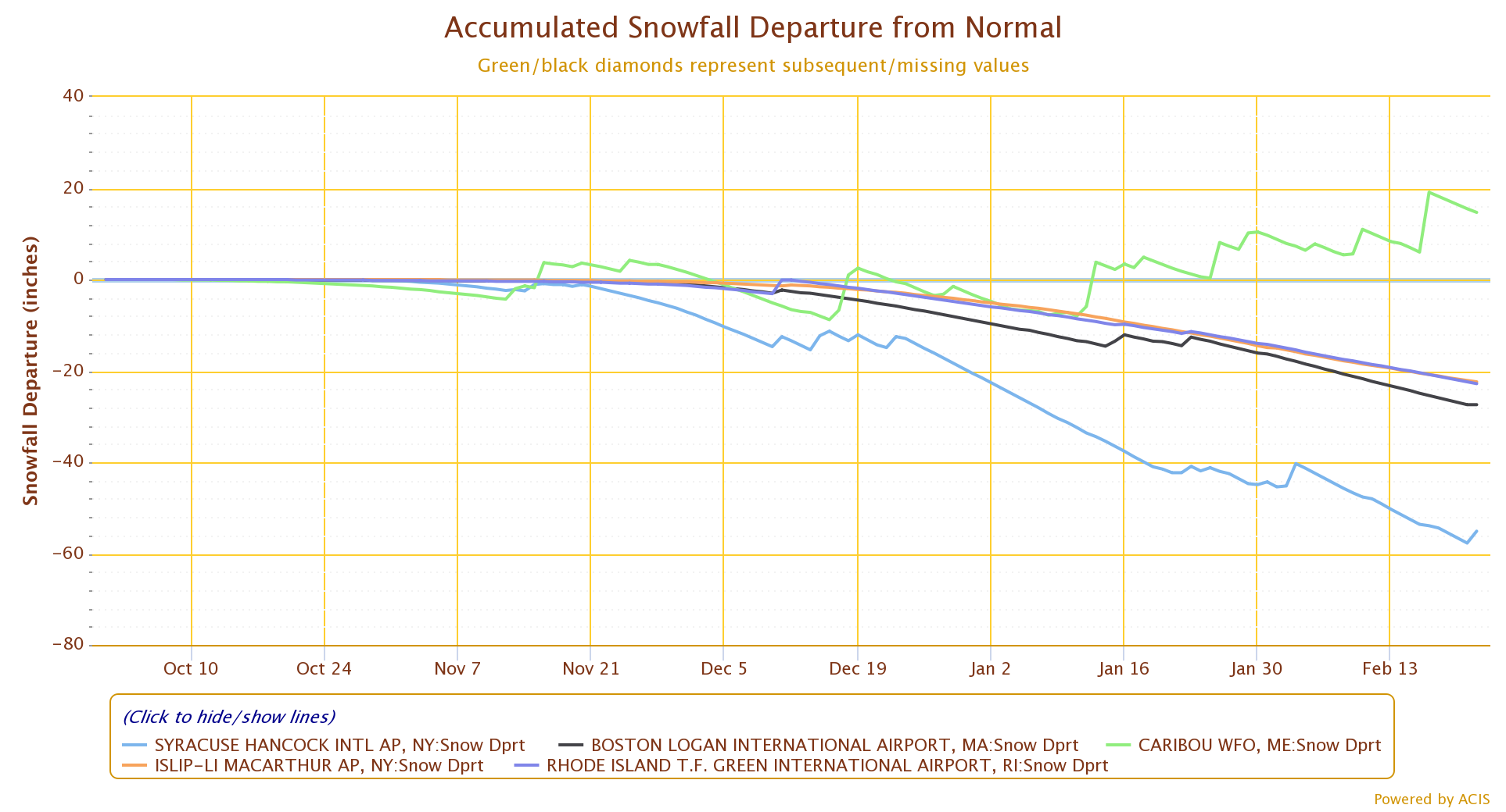
- This week’s snowfall and rainfall have been helpful, but seasonal snowfall deficits remain a concern. (Please see the Accumulated Snowfall Departure From Normal chart and the Snowfall Departure map below.)
- Frozen ground in the northernmost portions of New York and New England makes it difficult to assess the full impact of precipitation events from the last two months.
- State drought task forces and monitoring committees are using this time to review plans and response activities of the previous year in preparation for future drought episodes.
Current U.S. Drought Monitor map for the Northeast Drought Early Warning System (DEWS) with data valid for February 21, 2023. The U.S. Drought Monitor is updated each Thursday to show the location and intensity of drought across the country.
According to the latest U.S. Drought Monitor:
- 1.94% of the Northeast is experiencing Abnormally Dry (D0) conditions
- 0% of the Northeast is in drought (D1–D4)
U.S. Drought Monitor Categories
Abnormally Dry (D0)
Abnormally Dry (D0) indicates a region that is going into or coming out of drought. View typical impacts by state.
Moderate Drought (D1)
Moderate Drought (D1) is the first of four drought categories (D1–D4), according to the U.S. Drought Monitor. View typical impacts by state.
Severe Drought (D2)
Severe Drought (D2) is the second of four drought categories (D1–D4), according to the U.S. Drought Monitor. View typical impacts by state.
Extreme Drought (D3)
Extreme Drought (D3) is the third of four drought categories (D1–D4), according to the U.S. Drought Monitor. View typical impacts by state.
Exceptional Drought (D4)
Exceptional Drought (D4) is the most intense drought category, according to the U.S. Drought Monitor. View typical impacts by state.
Current U.S. Drought Monitor map for the Northeast Drought Early Warning System (DEWS) with data valid for February 21, 2023. The U.S. Drought Monitor is updated each Thursday to show the location and intensity of drought across the country.
According to the latest U.S. Drought Monitor:
- 1.94% of the Northeast is experiencing Abnormally Dry (D0) conditions
- 0% of the Northeast is in drought (D1–D4)
Current Conditions
Water Year 2023 Snowfall Departure (Inches)
| Location | Oct. 1, 2022 – Feb. 22, 2023 Snowfall (in.) | Normal (in.) | Departure from Normal (in.) | Rank (Least Snowy) |
|---|---|---|---|---|
| Syracuse, NY | 43.6 | 98.7 | -55.1 | 14 |
| Rochester, NY | 23.3 | 76.1 | -52.8 | 2 |
| Worcester, MA | 19.9 | 53.3 | -33.4 | 10 |
| Hartford, CT | 9.9 | 38.4 | -28.5 | 6 |
| Boston, MA | 8.5 | 35.9 | -27.4 | 5 |
| Bridgeport, CT | 0.8 | 23.7 | -22.9 | 1 |
| Burlington, VT | 39.0 | 61.8 | -22.8 | |
| Providence, RI | 4.9 | 27.7 | -22.8 | 4 |
| Binghamton, NY | 39.5 | 62.0 | -22.5 | 8 |
| Islip, NY | 0.7 | 23.1 | -22.4 | 1 |
| Central Park, NY | 0.4 | 22.6 | -22.2 | 1 |
| LaGuardia Airport, NY | 0.6 | 22.2 | -21.6 | |
| Portland, ME | 29.4 | 48.9 | -19.5 | 16 |
| Kennedy Airport, NY | 0.2 | 19.5 | -19.3 | 1 |
| Albany, NY | 27.4 | 42.4 | -15.0 | |
| Concord, NH | 36.0 | 48.1 | -12.1 | |
| Caribou, ME | 96.8 | 82.1 | 14.7 | 17 snowiest |
| Buffalo, NY | 118.7 | 75.2 | 43.5 | 5 snowiest |
Snowfall departures in selected cities across the Northeast DEWS region are in the double digits, with some New York state sites experiencing their least snowy winters between the dates of October 1 and February 22. Yellow shading indicates record low snowfall, while blue indicates locations with above-normal snowfall. Source: ACIS.
Accumulated Snowfall Departure from Normal
State-Reported Conditions and Impacts
Connecticut
- Connecticut Drought Information Center
- Drought Impacts:
- January 16, 2023: The Sun – Westerly Town Council Planning for Alternate Water Sources
Maine
- Maine Drought Task Force
- Drought Impacts:
- February 2, 2023: Maine Public – Maine Farmers Need Help Paying For More Water Sources
- January 20, 2023: WGME13 – Drought and Maine’s Honey Bees
- January 16, 2023: Maine Public Radio – Western Drought Good For Maine’s Potato Farmers
Massachusetts
- Massachusetts Drought Management Task Force
- Drought Impacts:
- February 14, 2023: New England Public Media – Nine Months of Drought Over/Lack Of Snow Still A Concern
- February 14, 2023: CapeCod.com – Drought Ends/Thanks For Conservation Efforts/Continue Efforts and Conduct Audits
- February 13, 2023: WWLP News22 – State Declared Free Of Drought
- February 8, 2023: Trends In Plant Science – Measuring Drought Stress In Plants
- January 28, 2023: iBerkshires.com – Drought In Berkshire County And The Rest of the Commonwealth
New Hampshire
- New Hampshire Department of Environmental Services: Drought
- Drought Impacts:
- February 16, 2023: Carriage Towne News – Rain Barrels For Sale
New York
- New York State Department of Environmental Conservation (DEC): Drought
- Drought Impacts:
- February 14, 2023: The East Hampton Star – New Water Conservation Rules Include Financial Incentives To Conserve
- February 14, 2023: The Examiner – Pocantico Lake Protection AS A Hedge Against Climate Change Impacts
- February 6, 2023: News12 New Jersey – NYC Area Snowfall: Lower Amounts and Later In The Season
- January 31, 2023: Rochester First.Com – Concerns About Maple Sugar Season
- January 30, 2023: Yahoo! News – NYC Snow Drought Finally Broken
Rhode Island
- Rhode Island Water Resources Board: Drought Management Program
- Drought Impacts:
- February 6, 2023: EcoRI News – More On Controlled Burns on State Land
- February 3, 2023: Patch – Planned Burns To Reduce Wildfire Risk
- February 3, 2023: East Bay Media Group – More On Prescribed Fires
Vermont
Find additional impacts through the National Drought Mitigation Center’s Drought Impact Reporter.
Find local drought information by address, city or zip code on Drought.gov.
Outlooks
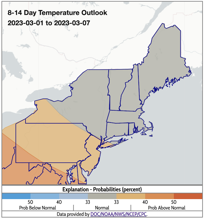
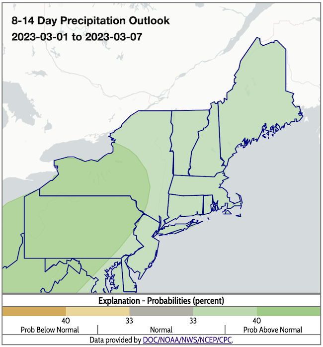
- According to the Climate Prediction Center's 8–14 day outlooks (valid March 1–7), odds favor near-normal temperatures across the Northeast, except for far-western New York, where odds slightly favor above-normal temperatures. There is a greater likelihood of above-normal precipitation across the region.
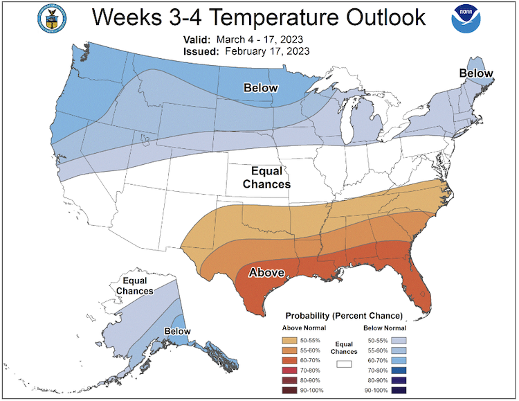
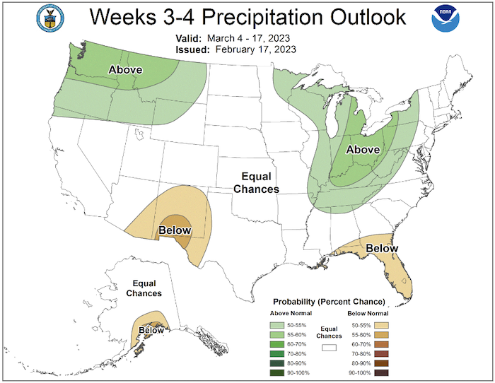
- The week 3–4 outlook (valid March 4–17, 2023) favors above-normal precipitation for central and western New York, with equal chances of above- or below-normal precipitation in the rest of the region. Below-normal temperatures, meanwhile, are favored for the entire Northeast.
8–14 Day Temperature and Precipitation Outlooks
Week 3–4 Temperature and Precipitation Outlooks
What We Are Watching
- Northeast Region Climate Services Webinar: Register now for the Northeast Region Climate Services Webinar on Tuesday, February 28. The special topic for this webinar is Climate Projections.
- Linking Drought, Wildfires, and Air Pollution Across the U.S.: As droughts, and thus wildfire risk, become more frequent with the trend of climate warming, it is important to be able to predict how these phenomena will impact pollution in the future. A recent study, funded in part by the NOAA Climate Program Office’s Atmospheric Chemistry, Carbon Cycle and Climate (AC4) Program, uses a drought index (a dataset designed to take into account both precipitation and evapotranspiration) to determine the likelihood of drought, to explore the relationship between PM2.5 and drought across the continental U.S.
- Drought and Prescribed Fire: Read this December 2022 report on the demand for prescribed fire on private lands in the Mid-Atlantic (includes New York state).
- Drought Monitoring and Plant Stress: February 8, 2023: Cell Press – Stress Biomarkers For Drought
- Drought and Mental Health: February 10, 2023: FOX Business News – Farmers’ Mental Health Crisis
Featured Resources
- National Interagency Coordination Center Fire Dashboard
- Story Maps: Eastern Area Coordination Center Short-Term Outlook and Long-Term Assessment
Additional Resources
- Look back at previous Northeast DEWS Drought Status Updates
- Your local National Weather Service office
- NOAA Regional Climate Services Monthly Webinar Series (next webinar is on February 28)
- USDA Northeast Climate Hub
- USGS New England and New York Water Science Centers
Contacts for More Information
Sylvia Reeves
Regional Drought Information Coordinator (Northeast DEWS)
NOAA/CIRES/National Integrated Drought Information System (NIDIS)
Email: sylvia.reeves@noaa.gov
Ellen L. Mecray
Regional Climate Services Director, Eastern Region
NOAA/NESDIS/National Centers for Environmental Information
Email: Ellen.L.Mecray@noaa.gov
Prepared By
Sylvia Reeves
NOAA/National Integrated Drought Information System (NIDIS), CIRES
Samantha Borisoff, Jessica Spaccio, Keith Eggleston, Art DeGaetano
Northeast Regional Climate Center
Ellen Mecray
Regional Climate Services Director, Eastern Region, NOAA
Gardner Bent
USGS New England Water Science Center
In partnership with National Weather Service Offices of the Northeast and State Climate Offices of the Northeast.
This drought status update is issued in partnership between the National Oceanic and Atmospheric Administration (NOAA), U.S. Geological Survey, and the U.S. Department of Agriculture (USDA) to communicate concern for drought expansion and intensification within the Northeast U.S. based on recent conditions and the forecasts and outlooks. NIDIS and its partners will issue future drought status updates as conditions evolve.
