Severe drought (D2) coverage expanded in southern New England—a trend that may continue.
For more details, see the Northeast Drought Early Warning System Dashboard.
Key Points
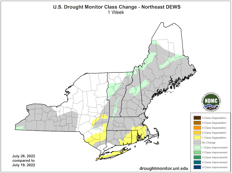
- Severe drought (D2) expanded southward into portions of eastern Massachusetts and Connecticut and covered most of Rhode Island.
- Moderate drought (D1) pushed into some of the eastern-most counties of New York and expanded across the western Southern Tier of the state.
- Abnormally dry conditions (D0) gained a foothold on Long Island and expanded across additional counties in southeastern New York.
- Welcomed rainfall paused deterioration in northern New England and the Northern Tier counties of western New York.
- Multiple locations had near record-setting long streaks of days with highs of at least 90°F from June 19–25, with the heat exacerbating the dry conditions. JFK Airport observed a record-tying seven consecutive days with a low of 75°F or higher.
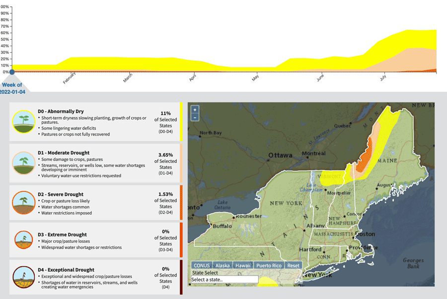
Current U.S. Drought Monitor map for the Northeast Drought Early Warning System with data valid for July 26, 2022. The U.S. Drought Monitor is updated each Thursday to show the location and intensity of drought across the country.
According to the latest U.S. Drought Monitor:
- Severe drought (D2) conditions exists in 4.99% of the region.
- Moderate drought (D1) conditions exist in 29.02% of the region.
- Abnormally dry (D0) conditions exist in 30.87% of the region.
U.S. Drought Monitor Categories
Current U.S. Drought Monitor map for the Northeast Drought Early Warning System with data valid for July 26, 2022. The U.S. Drought Monitor is updated each Thursday to show the location and intensity of drought across the country.
According to the latest U.S. Drought Monitor:
- Severe drought (D2) conditions exists in 4.99% of the region.
- Moderate drought (D1) conditions exist in 29.02% of the region.
- Abnormally dry (D0) conditions exist in 30.87% of the region.
Current Conditions
U.S. Drought Monitor 1-Week Change Map
Animation: 2022 U.S. Drought Monitor Conditions in the Northeast
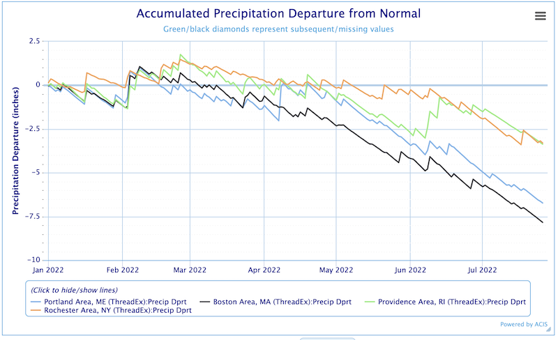
Accumulated Precipitation Departure from Normal
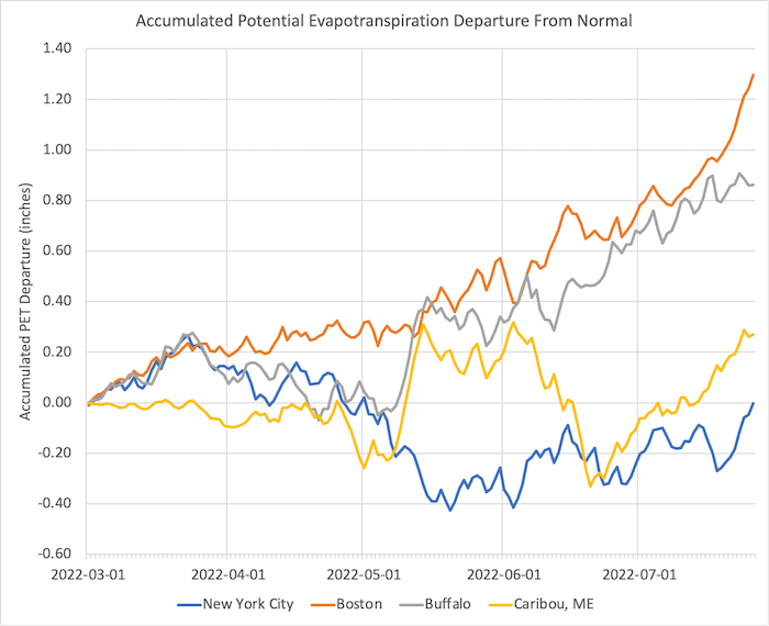
Accumulated Potential Evapotranspiration (PET) Departure from Normal
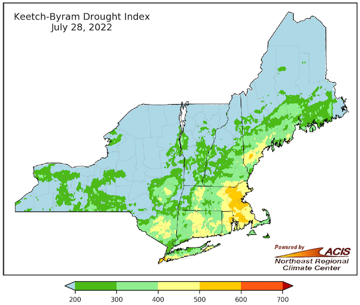
Keetch-Byram Drought Index (KBDI)
State-Reported Impacts
National
- July 14, 2022 CNN – National Drought
Connecticut
- July 18, 2022: State Press Release – Extreme Heat Protocols
- July 17, 2022: New Haven Register – Editorial: CT Drought Conditions
- July 15, 2022: The Day – Local Farms Feel Drought Impact
- July 15, 2022: Fox61 News – Water Services Urge Conservation
- July 14, 2022: CTInsider – Governor Urges Water Conservation
Maine
- July 27, 2022: Bangor Daily News – Stonington Trucking in Water
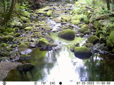
- July 22, 2022: Condition Monitoring Observer Report (CMOR) for Androscoggin County, Maine
Massachusetts
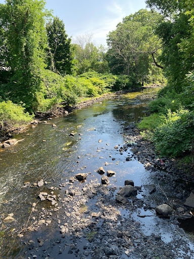
- July 28, 2022: Boston Globe/MSN – Photos of the Drought
- July 25, 2022: MetroWest Daily News – Water Bans
- July 23, 2022: Topsfield, MA Town website – Water Restrictions
- July 21, 2022: The Ipswich Local News – Gloucester Water Conservation
- July 11, 2022: Spectrum News – Drought Impacting Christmas Trees
New York
- July 21, 2022: Spectrum News – Cortland Dairy Farm Impacted by Dryness
- July 16, 2022: Spectrum News – Drought Relief?
Rhode Island
- July 26, 2022: ABC6 – Emergency Water Ordinance in Westerly
- July 22, 2022: The Providence Journal – Reseeding Hay Crop
Outlooks
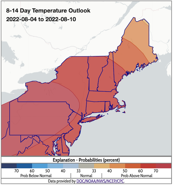
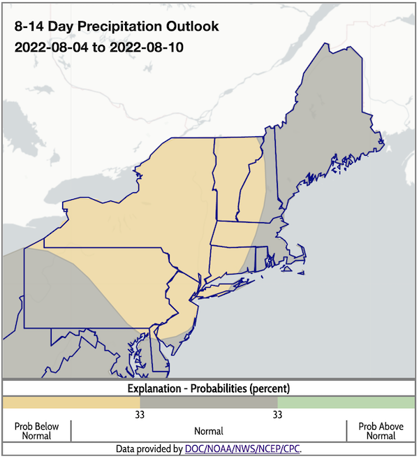
- According to the Climate Prediction Center's 8–14 day outlook (valid August 4–10), odds favor above-normal temperatures across the Northeast. There is a greater likelihood of below-normal precipitation for New York, most of Vermont, and eastern New Hampshire, Massachusetts, and Connecticut; odds favor near-normal precipitation in the rest of the region.
- With above-normal temperatures and below- or near-normal rainfall predicted for New York and New England, drought and dryness are expected to persist and possibly intensify.
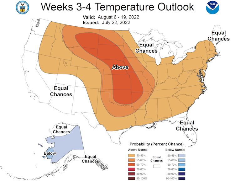
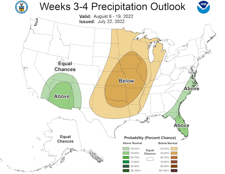
- The week 3–4 outlook (valid August 6–19) shows an increased probability of above-normal temperatures for most of the region, except for Maine and the northeastern corner of New Hampshire, where there are equal chances of above- and below-normal temperatures. The entire Northeast has equal chances of above- and below-normal precipitation.
8–14 Day Temperature Outlook
8–14 Day Precipitation Outlook
Temperature Outlook Week 3–4
Precipitation Outlook Week 3–4
What We Are Watching
Monitoring potential drought introduction, expansion, or intensification on Northeast DEWS borders:
- Drought expanded and intensified in New Jersey with consecutive days of 100+ degree temperatures. Some towns have issued water restrictions.
- July 22, 2022: CBS News New York – New Jersey Fire Restrictions
- New Jersey Forest Fire Service Dashboard
Monitoring agriculture reporting systems:
- July 28, 2022, New York field crop conditions: Corn and soybeans are struggling in several New York counties.
- Dutchess – Pastures need rain to recoup. Late-planted corn is not faring well, but early-planted corn is looking good.
- Wyoming/Geneseo/Livingston – Soybeans are struggling.
- Lewis – Variable dry conditions.
- Oneida – With rain, wheat yields are okay. Second hay cutting is light.
- Chautauqua – Some short corn.
- Rensselaer – Short corn; may need to replant with other crops
- July 26, 2022, American Agriculturist – For some crops, rains came too late
- July 21, 2022, New York field crop conditions: Corn is dry and/or curling in several New York counties.
- Columbia/Schenectady/Albany – Corn is curling in parts of some fields.
- Central and Finger Lakes Regions:
- Aurora – Dry soils, stressed plants.
- Seneca Lake – Corn plants are also curling.
- Tompkins County – Dry corn, irrigating at Musgrave Farm.
- Cortland/Chemung – Rain didn’t offer much relief. Various stages of corn stress are reported. Very short and very curled corn in some areas.
- Tioga County, Owego – Corn is really dry.
Additional Resources
- Heat.gov
- On July 26, the Biden Administration, through the interagency National Integrated Heat Health Information System (NIHHIS), launched Heat.gov, a new website to provide the public and decision-makers with clear, timely, and science-based information to understand and reduce the health risks of extreme heat.
- Maine's Dry Well Survey
- The Maine Emergency Management Agency has prepared a survey to report dry wells and guide individuals toward available opportunities for assistance if and when they become available.
- Look back at previous Northeast DEWS Drought Status Updates
- Your local National Weather Service office
- NOAA Regional Climate Services Monthly Webinar Series (next webinar is on August 30)
- USDA Northeast Climate Hub
- USGS New England and New York Water Science Centers
Contacts for More Information
Sylvia Reeves
Regional Drought Information Coordinator (Northeast DEWS)
NOAA/CIRES/National Integrated Drought Information System (NIDIS)
Email: sylvia.reeves@noaa.gov
Ellen L. Mecray
Regional Climate Services Director, Eastern Region
NOAA/NESDIS/National Centers for Environmental Information
Email: Ellen.L.Mecray@noaa.gov
Prepared By
Sylvia Reeves
NOAA/National Integrated Drought Information System (NIDIS), CIRES
Samantha Borisoff, Jessica Spaccio, Keith Eggleston, Art DeGaetano
Northeast Regional Climate Center
Ellen Mecray
Regional Climate Services Director, Eastern Region, NOAA
David Hollinger
USDA Climate Hubs
Gardner Bent
USGS New England Water Science Center
In partnership with National Weather Service Offices of the Northeast and State Climate Offices of the Northeast.
This drought status update is issued in partnership between the National Oceanic and Atmospheric Administration (NOAA), U.S. Geological Survey, and the U.S. Department of Agriculture (USDA) to communicate concern for drought expansion and intensification within the Northeast U.S. based on recent conditions and the forecasts and outlooks. NIDIS and its partners will issue future drought status updates as conditions evolve.
