Multiple Years of Drought Continue to Challenge the Pacific Northwest
Key Points
- Drought conditions deteriorated across the Pacific Northwest. 70% of the region is in Moderate to Extreme Drought (D1-D3), according to the U.S. Drought Monitor. Extreme Drought (D3) is present in western Washington, northern Idaho, and western Montana. Drought is most widespread across Idaho and Washington, where 86% and 78% of the state’s area, respectively, is in drought.
- Washington State issued a drought declaration for an unprecedented third year in a row. Northern Idaho has seen drought conditions present for nearly three years. Oregon, despite improved conditions this winter, is still experiencing long-term drought impacts on top of recent drying. The governor of Oregon recently declared drought emergencies for Lincoln and Baker counties.
- Precipitation deficits are substantial across the region. Oregon recorded its 6th, Idaho its 7th, and Washington its 3rd driest May-June on record, with longer-term precipitation deficits mounting due to below-normal snowpack, rapid melt-out, and significantly above-normal temperatures.
- Temperatures continue to be much above normal across the region. Oregon recorded its 7th, Idaho its 8th, and Washington its 13th warmest May-June on record. Warmer temperatures contributed to early and rapid snow melt, deepening water supply impacts across the region.
- Streamflow runoff fell much below normal. Some streams across Oregon reached record-low streamflows. Impacts of reduced streamflow include the limited ability to fill reservoirs, less water for irrigation and municipal use, reduced recreation, and increased stream temperatures.
- Conditions are likely to deteriorate further throughout the summer dry season. Multiple years with above-normal precipitation may be required to make up for deficits and improve long-term drought impacts.
This update is based on data available as of Monday, July 14, 2025 at 7 a.m. PT. We acknowledge that conditions are evolving.
Current U.S. Drought Monitor map for the Pacific Northwest, as of July 8, 2025. The U.S. Drought Monitor (USDM) is updated each Thursday to show the location and intensity of drought across the country using 5 classifications: Abnormally Dry (D0), showing areas that may be going into or are coming out of drought, and four levels of drought (D1–D4).
The U.S. Drought Monitor is a joint effort of the National Drought Mitigation Center, U.S. Department of Agriculture, and National Oceanic and Atmospheric Administration.
A drought index combines multiple drought indicators (e.g., precipitation, temperature, soil moisture) to depict drought conditions. For some products, like the U.S. Drought Monitor, authors combine their analysis of drought indicators with input from local observers. Other drought indices, like the Standardized Precipitation Index (SPI), use an objective calculation to describe the severity, location, timing, and/or duration of drought.
Learn MorePeriods of drought can lead to inadequate water supply, threatening the health, safety, and welfare of communities. Streamflow, groundwater, reservoir, and snowpack data are key to monitoring and forecasting water supply.
Learn MoreDrought can reduce the water availability and water quality necessary for productive farms, ranches, and grazing lands, resulting in significant negative direct and indirect economic impacts to the agricultural sector. Monitoring agricultural drought typically focuses on examining levels of precipitation, evaporative demand, soil moisture, and surface/groundwater quantity and quality.
Learn MoreU.S. Drought Monitor Categories
D0 - Abnormally Dry
Abnormally Dry (D0) indicates a region that is going into or coming out of drought. View typical impacts by state.
D1 - Moderate Drought
Moderate Drought (D1) is the first of four drought categories (D1–D4), according to the U.S. Drought Monitor. View typical impacts by state.
D2 - Severe Drought
Severe Drought (D2) is the second of four drought categories (D1–D4), according to the U.S. Drought Monitor. View typical impacts by state.
D3 - Extreme Drought
Extreme Drought (D3) is the third of four drought categories (D1–D4), according to the U.S. Drought Monitor. View typical impacts by state.
D4 - Exceptional Drought
Exceptional Drought (D4) is the most intense drought category, according to the U.S. Drought Monitor. View typical impacts by state.
Total Area in Drought (D1–D4)
Percent area of the Pacific Northwest that is currently in drought (D1–D4), according to the U.S. Drought Monitor.
Current U.S. Drought Monitor map for the Pacific Northwest, as of July 8, 2025. The U.S. Drought Monitor (USDM) is updated each Thursday to show the location and intensity of drought across the country using 5 classifications: Abnormally Dry (D0), showing areas that may be going into or are coming out of drought, and four levels of drought (D1–D4).
The U.S. Drought Monitor is a joint effort of the National Drought Mitigation Center, U.S. Department of Agriculture, and National Oceanic and Atmospheric Administration.
The U.S. Drought Monitor is updated every Thursday morning, with data valid through 7 a.m. ET the previous Tuesday.
A drought index combines multiple drought indicators (e.g., precipitation, temperature, soil moisture) to depict drought conditions. For some products, like the U.S. Drought Monitor, authors combine their analysis of drought indicators with input from local observers. Other drought indices, like the Standardized Precipitation Index (SPI), use an objective calculation to describe the severity, location, timing, and/or duration of drought.
Learn MorePeriods of drought can lead to inadequate water supply, threatening the health, safety, and welfare of communities. Streamflow, groundwater, reservoir, and snowpack data are key to monitoring and forecasting water supply.
Learn MoreDrought can reduce the water availability and water quality necessary for productive farms, ranches, and grazing lands, resulting in significant negative direct and indirect economic impacts to the agricultural sector. Monitoring agricultural drought typically focuses on examining levels of precipitation, evaporative demand, soil moisture, and surface/groundwater quantity and quality.
Learn MoreCurrent Conditions and Impacts for the Pacific Northwest
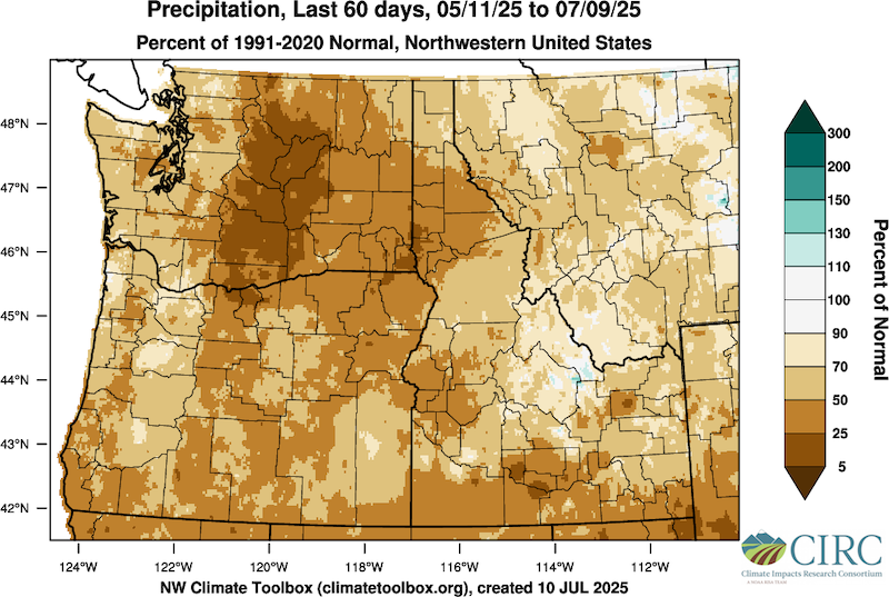
- Drought conditions have deteriorated across the region since late spring and early summer. Significant precipitation deficits are present throughout the region, with the largest deficits in south central and north central Washington, northern Oregon, and southern Idaho.
- Over the last 60 days, precipitation deficits were most substantial in the Yakima Basin, with most of the basin receiving less than 5% of normal precipitation. May-June was the driest period on record in Yakima and Kittitas counties in the Yakima Basin.
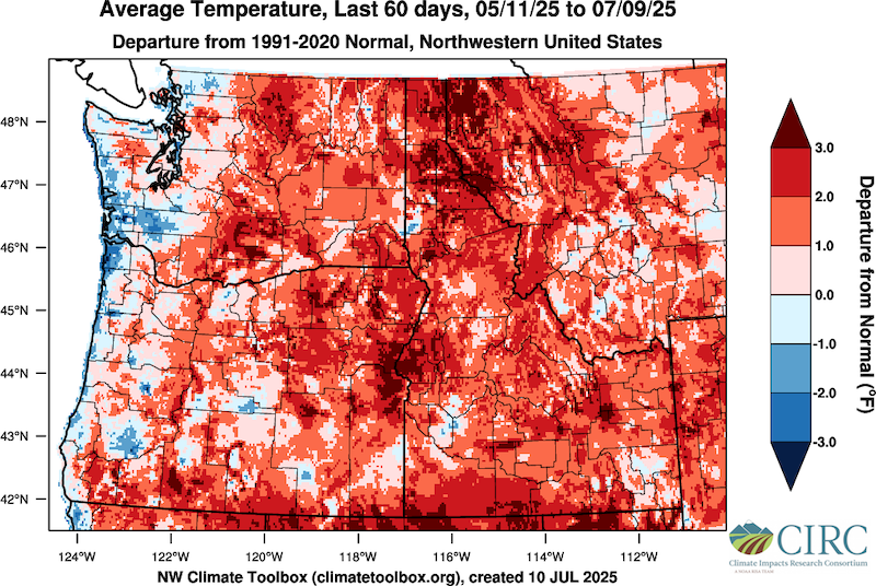
- Over the last 60 days, temperatures were 2-4° Fahrenheit (F) above normal across much of the region, with 4-5°F or greater departures from normal across parts of northern Idaho and northwestern Montana. Missoula County, Montana saw its 10th hottest May-June on record. Clearwater County, Idaho saw its 8th warmest May-June on record.
- Despite isolated areas of precipitation across the Pacific Northwest, deficits remain, leading to less water for irrigation, requests for drought emergency declarations, poor pasture conditions, and an early start to the wildfire season. Some irrigators fallowed land and ceased irrigation for some crops, leading to reduced yields and crop stress.
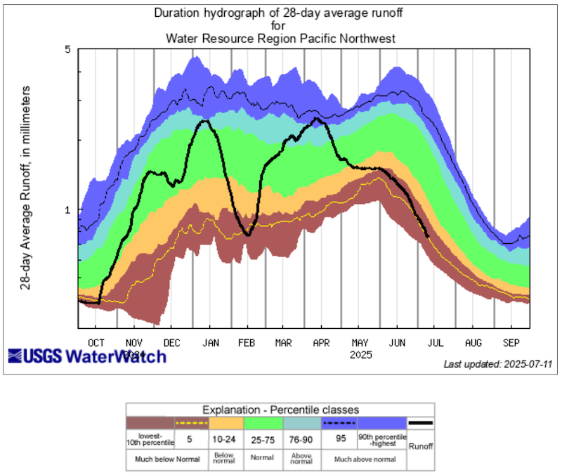
- Across the Pacific Northwest, stream runoff is now near the 5th percentile, meaning current values are lower than 95% of past runoff values. This is due to below-normal precipitation, above-average temperatures, and below-normal winter snowpack across most of the Pacific Northwest. Storage from the six Bureau of Reclamation reservoirs across the region is at its second lowest in the period of record from 1971-2025.
- The lack of snow and rapid melt-out in some places, followed by low precipitation and above-normal temperatures, led to an early risk for wildfire. Large active wildfires are present, including the Western Pines Fire, Pomas Fire, and Hope Fire in Washington, and Elk Fire in Oregon. Soil moisture values across the region demonstrate the ground is unusually dry.
- On June 5, the Washington Department of Ecology expanded its drought declaration from Yakima Basin watersheds to an additional 19 watersheds in the North and Central Cascade Mountains and parts of the Puget Sound area. Oregon also declared state drought emergencies in Lincoln and Baker counties. Lower streamflows, reservoirs that remain unfilled, and high demand are driving water supply issues.
Widespread Period of Near-Record Dryness for Central Washington
Warm Temperatures Deepen Drought Deterioration
Regional Streamflow Runoff at the 5th Percentile
Outlooks and Potential Impacts for the Pacific Northwest
- Forecasts for the next 7 days show widespread dry conditions across the region. If the forecasts prove accurate, soil moisture, crop, and streamflow conditions will continue to deteriorate.
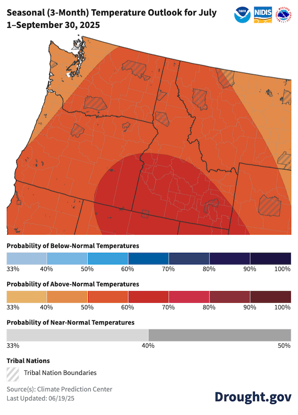
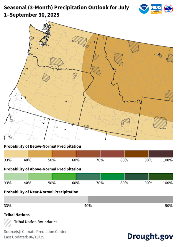
- The three-month outlook for June–August shows increased chances of below-normal precipitation and above-normal temperatures across the Pacific Northwest.
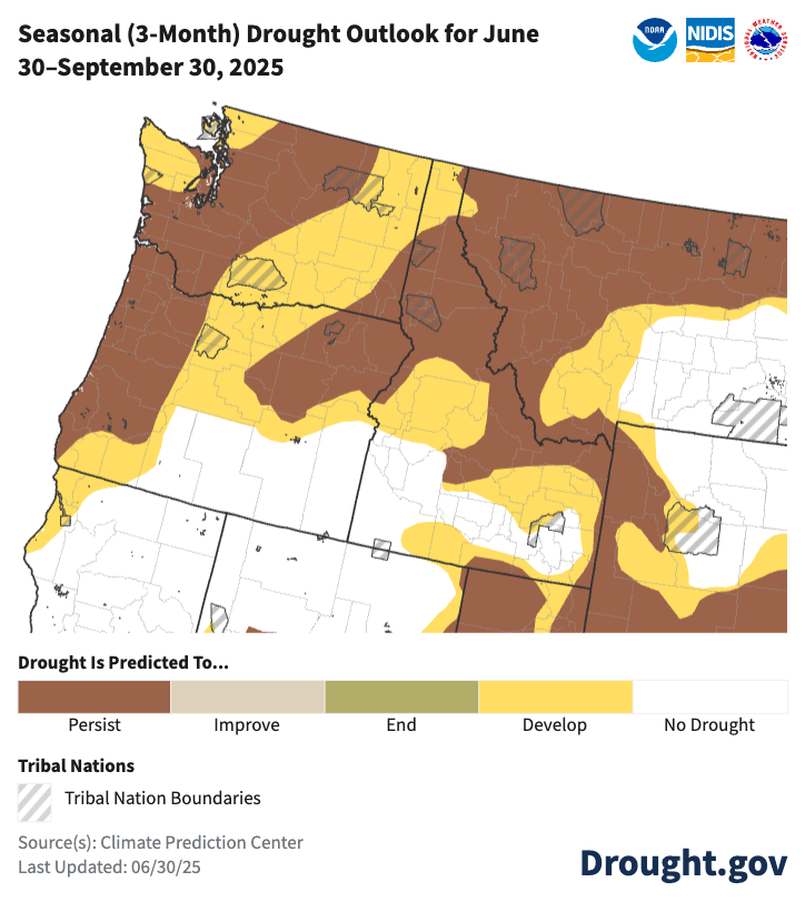
- Rapid expansion and intensification of drought is likely during the summer dry season, further deepening the long-term deficits and worsening impacts. Multiple years with above-normal precipitation may be required to make up for deficits and improve long-term drought impacts.
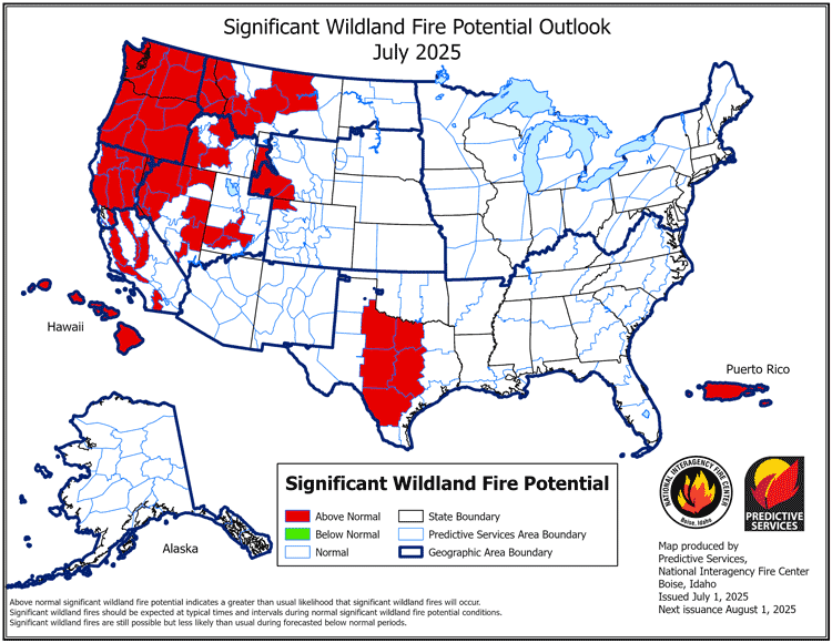
- Continued above-normal temperatures may increase the probability of wildland fires ignited by human activities and lightning, particularly dry lightning.
- For Washington’s Yakima Basin, on July 3, the Bureau of Reclamation announced 45% of the total water supply available for water right holders that are subject to sharing in times of shortage for July-September. Further agricultural impacts including crop stress and reduced yields can be expected.
- Low streamflows and subsequent increased water temperatures are expected to continue to impact fish passage and migration, resulting in stranding and increased fish mortality. Recreation impacts are also expected to continue across reservoirs and streams.
- Water supply impacts will likely continue. Low groundwater levels in wells, reduced municipal water supplies, and limited water available for fall irrigation are expected.
Hot and Dry Conditions Likely to Continue
Drought Favored to Persist and Expand Across the Region
Wildland Fire Outlook Above Normal Through September
Resources
- More local information is available from the following resources:
- To report or view local drought impact information:
- Relief resources:
- In Washington, the drought emergency declaration triggers relief options. The Washington Department of Ecology is enabled to distribute drought emergency grant funds and to expedite processing of emergency water transfer applications. More info: Drought Response
Prepared By
Jason Gerlich
Cooperative Institute for Research in Environmental Sciences (CIRES), NOAA’s National Integrated Drought Information System
Caroline Mellor
Washington State Department of Ecology
Holly Prendeville
U.S. Department of Agriculture Northwest Climate Hub
Erica Fleishman
OCCRI, Oregon State University
Karin Bumbaco
Washington State Climate Office, University of Washington
David Hoekema
Idaho Department of Water Resources
Larry O’Neill
Oregon Climate Service, Oregon State University
Russ Qualls
Idaho Climate Service, University of Idaho
This Drought Status Update is issued in partnership between the National Oceanic and Atmospheric Administration (NOAA), the Washington State Department of Ecology, OCCRI, Oregon Water Resources Department, USDA Natural Resources Conservation Service, Office of the Washington State Climatologist, Idaho Department of Water Resources, Idaho Climate Service and Oregon Climate Service to communicate potential areas of concern for drought expansion or development within the Pacific Northwest DEWS region on the basis of recent conditions and forecasts. NIDIS and its partners will issue future Drought Status Updates as conditions evolve.


