Winter snowpack is off to a great start. More is needed to improve long-term drought conditions.
Key Points
- Most of the Intermountain West experienced a cool and wet November.
- Exceptional (D4) drought has dropped to less than 0.5% of the region, persisting in central Utah and far northeastern Colorado.
- The area in severe (D2) to exceptional (D4) drought is at its lowest in two years.
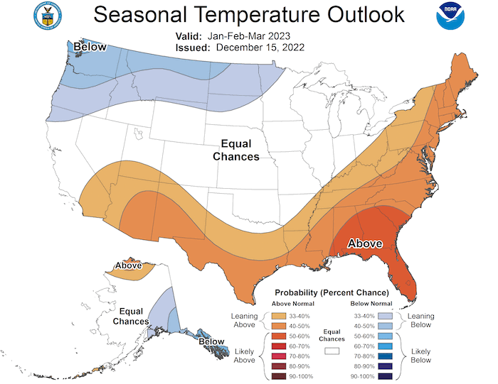
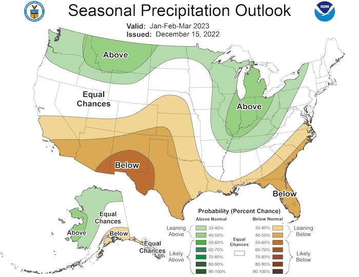
- NOAA’s seasonal outlook for January–March 2023 shows a warmer and drier-than-normal season ahead for the Southwest.
Current U.S. Drought Monitor map for the Intermountain West Drought Early Warning System (DEWS) region with data valid for December 13, 2022. The U.S. Drought Monitor is updated each Thursday to show the location and intensity of drought across the country.
U.S. Drought Monitor Categories
Abnormally Dry (D0)
Abnormally Dry (D0) indicates a region that is going into or coming out of drought. View typical impacts by state.
Moderate Drought (D1)
Moderate Drought (D1) is the first of four drought categories (D1–D4), according to the U.S. Drought Monitor. View typical impacts by state.
Severe Drought (D2)
Severe Drought (D2) is the second of four drought categories (D1–D4), according to the U.S. Drought Monitor. View typical impacts by state.
Extreme Drought (D3)
Extreme Drought (D3) is the third of four drought categories (D1–D4), according to the U.S. Drought Monitor. View typical impacts by state.
Exceptional Drought (D4)
Exceptional Drought (D4) is the most intense drought category, according to the U.S. Drought Monitor. View typical impacts by state.
Current U.S. Drought Monitor map for the Intermountain West Drought Early Warning System (DEWS) region with data valid for December 13, 2022. The U.S. Drought Monitor is updated each Thursday to show the location and intensity of drought across the country.
Current Drought Conditions and Outlook
U.S. Drought Monitor Conditions
- Exceptional (D4) drought persists in central Utah and northeastern Colorado.
- 8% of the region is experiencing Extreme (D3) drought or worse, the lowest amount since August 2020.
- Extreme (D3) drought conditions have been in place in this region since May 2020.
- Moderate (D1) or worse drought has been in the region since August 2009.
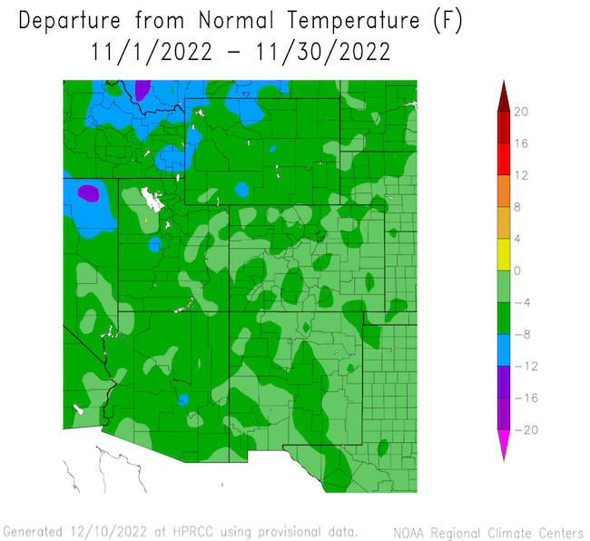
November Temperatures and Precipitation
- November was another cooler-than-normal month for the Intermountain West.
- Statewide November monthly temperature rankings:
- Arizona: 15th coolest November and coolest since 2000
- Colorado: 29th coolest November and coolest since 2000
- New Mexico: 29th coolest November and coolest since 2000
- Utah: 14th coolest November and coolest since 2000
- Wyoming: 19th coolest November and coolest since 2003
- Statewide November monthly temperature rankings:
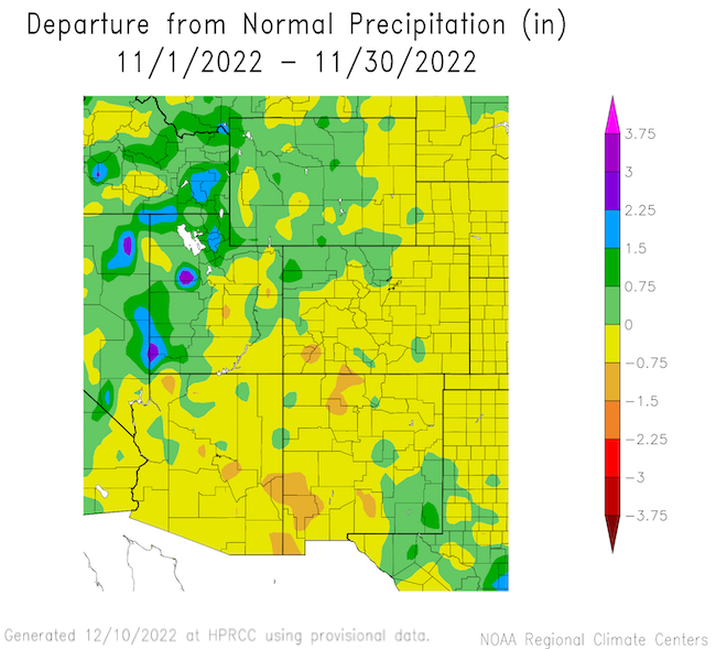
- Precipitation in November was generally average to below average across the Intermountain West, with the exception of the Great Basin and Wasatch regions of western and northern Utah.
Departure from Normal Temperature
Departure from Normal Precipitation
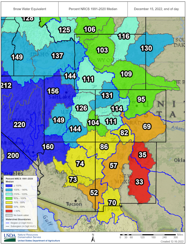
Snowpack
- Winter precipitation is essential for ameliorating drought in the Intermountain West. Winter snowpack acts as a natural reservoir that adds water to western rivers and streams during the spring melt.
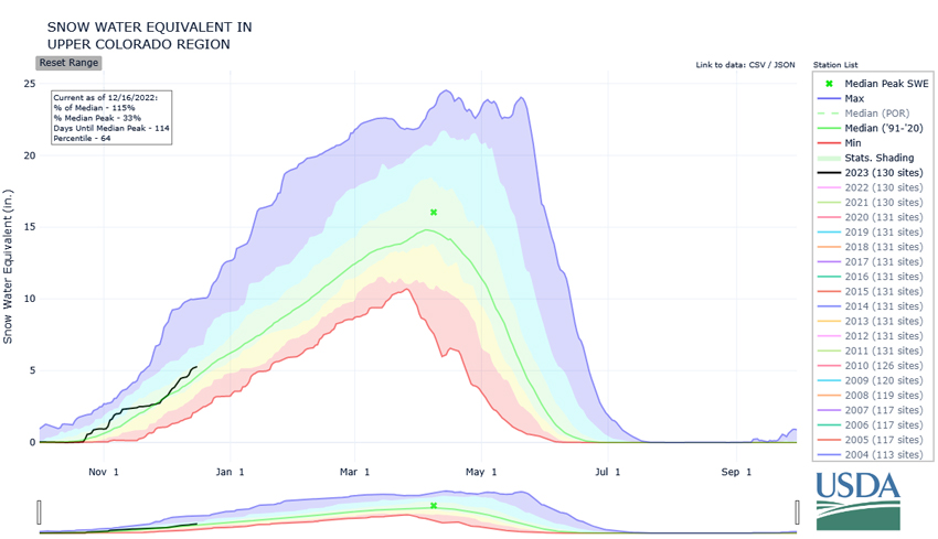
- As of December 15, the Upper Colorado River Basin had an average of 114% of normal snow water equivalent for this time of year. The lower Colorado River basin was at 118% of normal.
- Snowpack in New Mexico and eastern Arizona is below average for this point in the season; the snow water equivalent for the Rio Grande Basin is at only 69% of the 1991–2020 median.
- It’s too early in the season to anticipate the final snowpack for the year. For the Upper Colorado River Basin, the snowpack usually peaks around April 8 (118 days from the writing of this report).
Snow Water Equivalent Percent of Median: Intermountain West
Snow Water Equivalent in the Upper Colorado
Forecasts and Seasonal Outlooks: Late December 2022
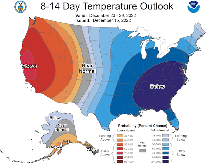
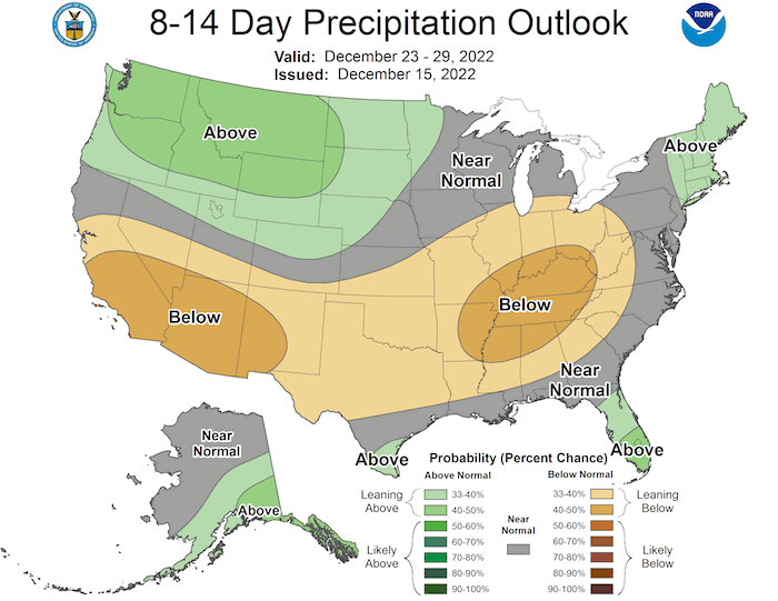
- According to the Climate Prediction Center's outlook for the last half of December:
- Temperature: Late December is likely to be warmer than normal for the western U.S., including Utah and Arizona. There is an equal chance of above- or below-normal temperatures for Wyoming, Colorado, and New Mexico.
- Precipitation: Odds slightly favor a wetter-than-normal conditions for this time of year for northern Utah and Wyoming. Odds also favor below-normal precipitation for New Mexico and Arizona.
Temperature Outlook: December 23–29, 2022
Precipitation Outlook: December 23–29, 2022
3-Month Outlooks for January–March 2023
Seasonal forecasts for January–March show a warmer and drier-than-normal winter for southern Arizona and southern New Mexico. There are only weak odds favoring cooler/wetter weather for far northern Wyoming.
January–March Temperature Outlook
January–March Precipitation Outlook
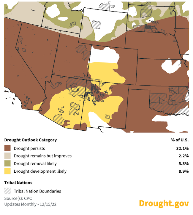
Seasonal Drought Outlook for December 15, 2022–March 31, 2023
- With the Climate Prediction Center's seasonal outlook strongly favoring below-normal precipitation for Arizona and New Mexico, consistent with La Niña conditions in the Pacific Ocean, the seasonal drought outlook shows continued or returning drought for the region for winter.
- Drought improvement is forecast for Wyoming.
December 15–March 31 Drought Outlook
State-Based Conditions and Impacts
Arizona
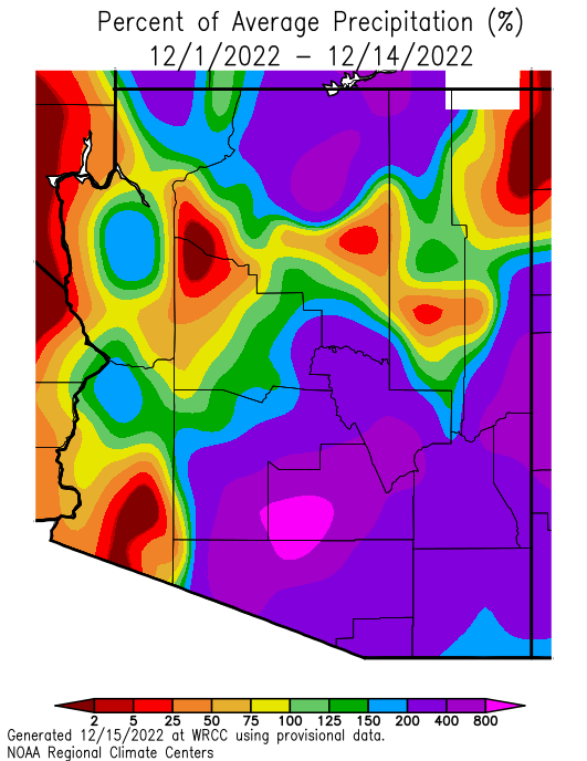
- November was a dry month for the state (0.49 inch of precipitation, with -0.36 inch departure from average). The first two weeks of December started strong with above-average precipitation over much of the state, but outlooks show the remainder of December trending dry.
- Snow water equivalent (SWE) for the Lower Colorado River basin is currently 127% of median (as of December 15, 2022), with SWE well above average from Flagstaff and along the Mogollon Rim (central Arizona), to average or slightly above average in the White Mountains (eastern Arizona).
- 61% of the state now has either no drought or abnormally dry (D0) conditions. Severe (D2) drought has decreased to only 8% of the state, mostly in northwestern and north-central portions of the state. Moderate (D1) drought decreased to 31%, largely remaining in the western and northern sections of the state.
Colorado
- Colorado was 2.2 degrees cooler than the 20th-century average, and 3–4 degrees cooler than the 1991–2020 normal during November. Cool conditions, especially in winter, temporarily arrest most drought impacts.
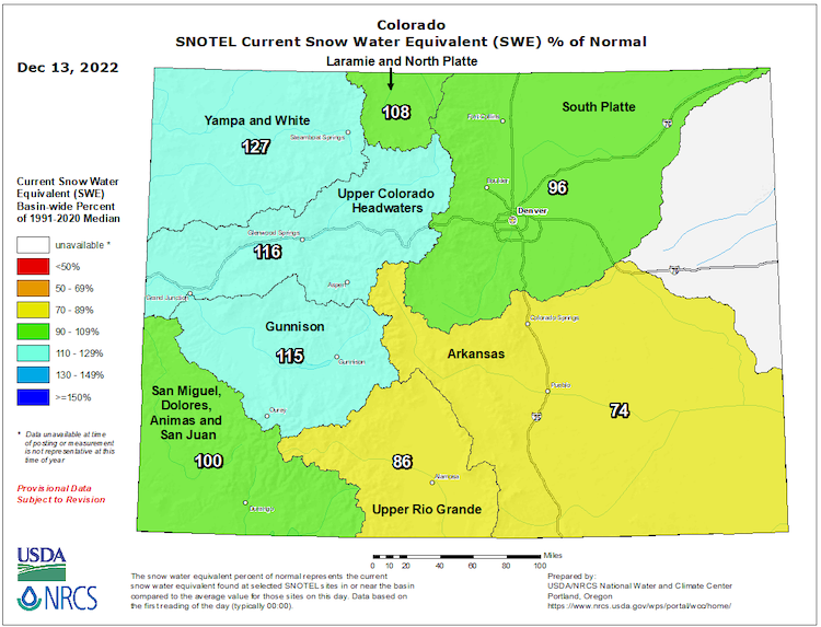
- A robust snowpack is the best way for Colorado to experience lasting drought relief. Current basin-wide snowpack numbers range from 74%–127% of normal, but there is still plenty of time for these numbers to get better or worse
- Reservoir storage entering this cold season is below the 10th percentile for Blue Mesa Reservoir: the largest reservoir in Colorado. McPhee Reservoir and John Martin Reservoir, two of Colorado’s other important, large reservoirs, are storing much below normal volumes this winter season.
New Mexico
- While precipitation in New Mexico in winter is usually quite a bit lower than what is received in the monsoon months, winter snowpack in northern New Mexico and southern Colorado mountains is essential for the state's hydrology.
- Water year to date precipitation has been lower than normal across much of northern New Mexico, including the San Juan River basin. Current Snowpack in the San Juan River Basin is 86% of normal.
- New Mexico has drought conditions ranging from no drought (Rio Arriba County) to exceptional (D4) drought (Union County).
- Some long-term drought signals, such as surface water storage, are showing the effects of decades of drought. This is particularly true along the Rio Grande where Caballo and Elephant Butte reservoirs are at 22% and 10% of capacity, respectively.
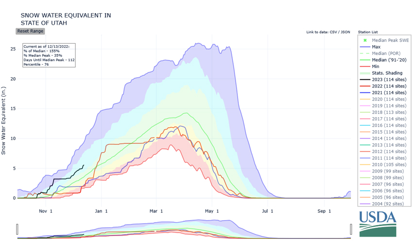
Utah
- Active weather has built up an ample snowpack across the state that currently stands at 155% of median for this time of year and 35% of the median April peak.
- With frozen soils locking in soil moisture content until springtime, the current soil moisture conditions across the state stand at near-normal amounts. This promises improved spring runoff efficiency over the recent drought years where dry soils limited the efficiency of spring runoff and reservoir recharge.
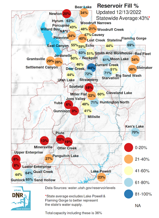
- Current statewide reservoir levels stand at 43% of capacity, reflecting the long-term drought impacts remain mostly unaffected by the last 6 months of above-average precipitation.
Wyoming
- Precipitation:
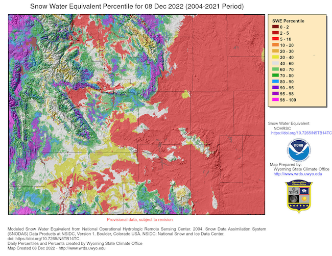
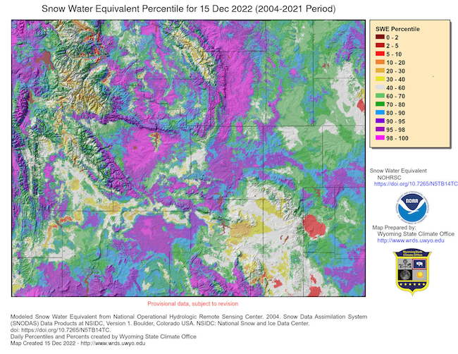
- A strong winter storm hit Wyoming (and much of the Midwest) December 12–14 accompanied by high winds, causing road and school closures. Snowfall at the Wyoming Mesonet station at Sheridan was about 15 inches.
- The snowfall brought snowpack totals to within a few percent of median for the Lower North Platte, Upper Green, Shoshone, and Bighorn Basins.
- The storm especially helped the eastern areas, which had generally been further below median. While the storm did help the South Platte River Basin, that area is still only at 50% of median.
- Remaining basins in Wyoming are well above their median snow water equivalent for this date.
- Soil Moisture:
- The northwest and east have seen some degradations in the last 30 days, while the remainder of the state has remained largely unchanged.
- Temperatures:
- Mean temperatures across the state for the last 30 days were below average, except for small portions of Platte County.
- East-central and southeastern Wyoming were mostly 0℉ to 3℉ below average.
- The far west, along with the Bighorn Basin, had mean temperatures 6℉ to 9℉ below average.
- The remainder of the Wyoming was 3℉ to 6℉ above average.
- Drought:
- The net change in drought status across the state over the last 30 days was minor. D0 (Abnormally Dry) was removed in Hot Springs and Washakie Counties, along with portions of Natrona, Johnson, and Sheridan Counties. Elsewhere, conditions remained the same.
Snow Water Equivalent: December 8 vs. December 15
For More Information
- NIDIS and its partners will issue future drought updates as conditions evolve.
- More local information is available from the following resources:
- Your state climatologist
- Your local National Weather Service office
- Western Water Assessment: Intermountain West Climate Dashboard
- Climate Assessment for the Southwest: Southwest Climate Outlook
In Case You Missed It
- Snow Drought Current Conditions and Impacts in the West: December 15, 2022
- California-Nevada Drought & Climate Outlook Webinar: November 28, 2022
- Southwest Drought Briefing: November 15, 2022
- Climate Engine Workshop and Training: November 9, 2022
Upcoming Events
- January 24, 2022, 1–1:35 pm MT: Southwest Drought Briefing
Prepared By
Joel Lisonbee
NOAA/National Integrated Drought Information System (NIDIS), Cooperative Institute for Research in Environmental Sciences (CIRES)
Erin Saffell
Arizona State Climatologist/Arizona State University
Peter Goble
Colorado Climate Center/Colorado State University
Jon Meyer
Utah Climate Center/Utah State University
Tony Bergantino
Water Resources Data System – Wyoming State Climate Office
This drought status update is issued in partnership between the National Oceanic and Atmospheric Administration (NOAA), and the offices of the state climatologist for Arizona, Colorado, New Mexico, Utah and Wyoming. The purpose of the update is to communicate a potential area of concern for drought expansion and/or development within the Intermountain West based on recent conditions and the upcoming forecast. NIDIS and its partners will issue future drought updates as conditions evolve.