Drought Persists Despite Some Improvement in the Upper Missouri River Basin
Key Points
- Fall precipitation improved drought conditions in portions of the Upper Missouri River Basin, primarily North Dakota and South Dakota, over the last two months according to the U.S. Drought Monitor. Despite this improvement, drought in other areas, like Montana, Wyoming, and eastern Colorado, has worsened or remained unchanged since late summer.
- Despite the recent improvement in drought conditions in North Dakota and South Dakota, there are still lingering impacts, including low water quantity and quality in stock ponds, short supply of feed sources, selling of cattle, and high stress levels among ranchers and other producers. Similar impacts to those in the Dakotas are also being felt across areas with persistent drought, like Montana.
- NOAA’s seasonal drought outlook for November 2021 through January 2022 predicts persistent drought across much of the Missouri River Basin, with the exception of Montana and northwest Wyoming where there is a chance for some improvement.
- Although short-term rain events may begin to replenish near-surface soil moisture, it can take months or multiple seasons to percolate into deeper subsoils, into groundwater aquifers, and to recharge reservoirs. It will be important to see how winter precipitation develops, in addition to the timing of melt and quantity of spring precipitation, to fully understand what conditions might be moving into next year’s growing season.
Current U.S. Drought Monitor map for the National Weather Service Central Region with data valid for November 2, 2021. The U.S. Drought Monitor is updated each Thursday to show the location and intensity of drought across the country. Drought categories show experts’ assessments of conditions related to dryness and drought including observations of how much water is available in streams, lakes, and soils compared to usual for the same time of year.
U.S. Drought Monitor Categories
Current U.S. Drought Monitor map for the National Weather Service Central Region with data valid for November 2, 2021. The U.S. Drought Monitor is updated each Thursday to show the location and intensity of drought across the country. Drought categories show experts’ assessments of conditions related to dryness and drought including observations of how much water is available in streams, lakes, and soils compared to usual for the same time of year.
Current Conditions
- Portions of the Upper Missouri River Basin have seen an improvement in drought conditions, according to the U.S. Drought Monitor (USDM) over the last two months (Figure 1). In North Dakota and South Dakota, some areas have improved by two to three categories on the USDM.
- Despite this improvement, other areas have remained the same or have seen worsening drought conditions. In Montana, most areas have not changed much, with the exception of a one to three category degradation in western Montana. Drought of any level covers 100% of the state, with extreme (D3) and exceptional (D4) drought covering nearly 70% of the state.
- Eastern Colorado has also seen an expansion of moderate to extreme (D1–D3) drought conditions over the last two months by one to three categories on the USDM. D1 to D3 drought also persists in Wyoming and western Nebraska.
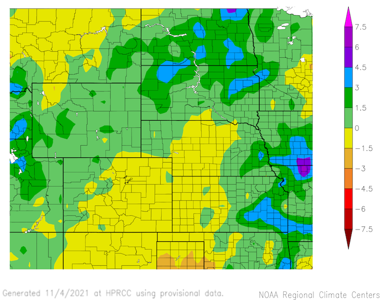
- Precipitation has been above-normal in North Dakota, South Dakota, Wyoming, and southeast Montana over the last 30 days (Figure 2). These areas have received up to 1.5 inches above normal precipitation, with some areas in the Dakotas receiving 1.5–4.5 inches above normal. On the other hand, much of Montana, eastern Colorado, central Nebraska, and western Kansas received below-normal precipitation (up to 1.5 inches below normal).
Figure 1. U.S. Drought Monitor 8-Week Change Map (September 7 compared to November 2, 2021)
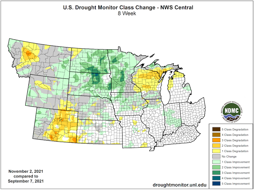
Figure 2. 30-day Departure from Normal Precipitation from October 5–November 3, 2021 (inches)
Impacts
- Fall is an important time for recharge of soil moisture as temperatures are cooler, so the moisture does not evaporate as much, and the ground is still unfrozen ahead of winter. Unfortunately, soil moisture recharge has not happened across much of Montana, northwest Wyoming, and northwest North Dakota (Figure 3). On the other hand, areas that received above-normal precipitation recently (South Dakota, and much of North Dakota and Wyoming) have seen a recharge in topsoil moisture, although subsoil moisture is still lacking.
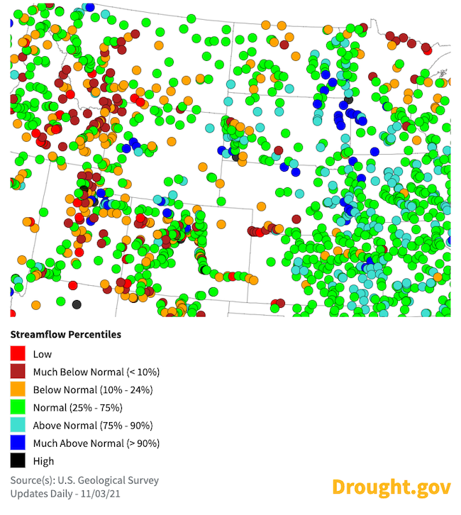
- Current streamflow from the U.S. Geological Survey shows conditions are mixed across the Missouri River Basin, with a significant number showing near-normal levels (green dots). There are some reports of below-normal streamflow in Montana, Wyoming, Colorado, and the western Dakotas and Nebraska (orange to red dots), as well as above-normal streamflow in eastern Dakotas, Nebraska, and portions of Wyoming (Figure 4).
- Despite the recent improvement in drought conditions in North Dakota and South Dakota, there are still lingering impacts, including low water quantity and quality in stock ponds, short supply of feed sources, selling of cattle, and high stress levels among ranchers and other producers.
- Similar impacts to those in the Dakotas are also being felt across areas with persistent drought, like Montana. There, winter wheat emergence is slightly behind the five-year average, but crop condition reporters note that without moisture they fear winter wheat could be damaged beyond repair (USDA National Agricultural Statistics Service Montana Crop Progress, Oct. 24, 2021). In addition, some areas are still warning of increased fire danger for this time of year. With reduced water, wildlife has also been found closer to roads and other areas rather than in the backcountry.
Figure 3. Soil Moisture Anomaly for October 26, 2021
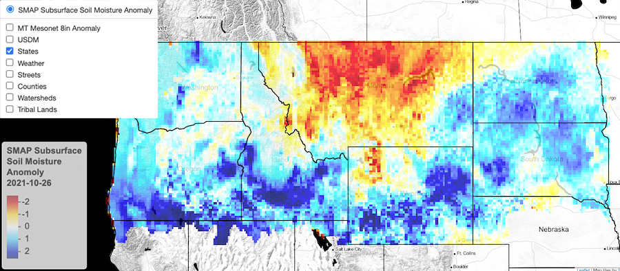
Figure 4. U.S. Geological Survey Streamflow Percentiles: November 3, 2021
Outlooks and Potential Impacts
- NOAA’s seasonal drought outlook for November 2021 through January 2022 predicts persistent drought across much of the Missouri River Basin, with the exception of Montana and northwest Wyoming where there is a chance for some improvement (Figure 5).
- The precipitation outlook for November 2021–January 2022 shows equal chances for either above-, near-, or below-normal precipitation across much of the Missouri River Basin. Chances for above-normal precipitation are slightly greater in Montana (hence the improvement in the drought outlook) and Wyoming (Figure 6).
- Although short-term rain events may begin to replenish near-surface soil moisture, it can take months or multiple seasons to percolate into deeper subsoils, into groundwater aquifers, and to recharge reservoirs. In addition, whether precipitation arrives as rain or snow influences how much water can be stored. It will be important to see how winter precipitation develops, in addition to the timing of melt and quantity of spring precipitation, to fully understand what conditions might be moving into next year’s growing season.
- La Niña climate conditions have emerged for the second winter in a row, according to NOAA’s Climate Prediction Center. More information on what this means for the Missouri River Basin can be found in last year’s La Niña report from NOAA (this will be updated soon for 2021–2022 conditions).
Figure 5. U.S. Drought Outlook (Valid October 12, 2021–January 31, 2022)
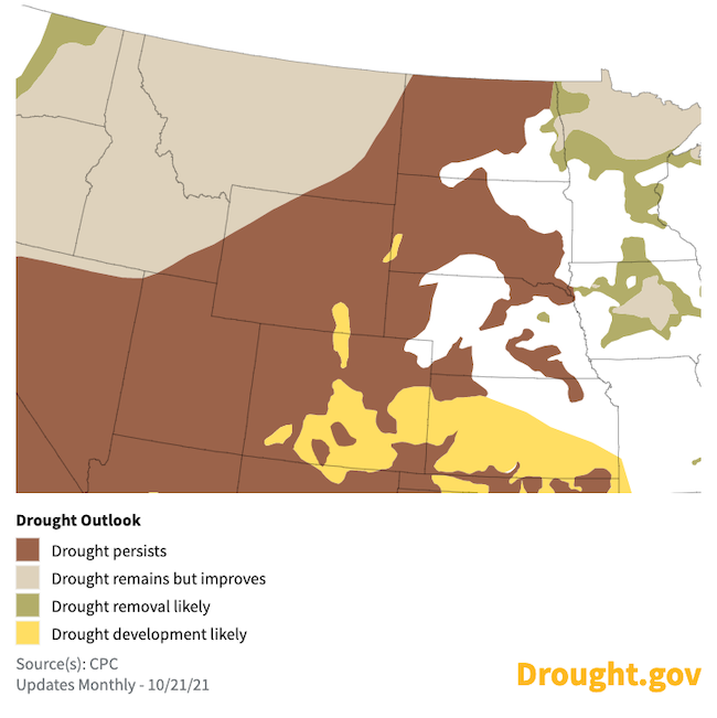
Figure 6. Precipitation Outlook for November 2021–January 2022
For More Information
- NIDIS and its partners will issue future updates as conditions evolve.
- More local information is available from the following resources:
- To report or view local drought impact information:
- Report your Drought Impacts through Condition Monitoring Observer Reports (CMOR)
- To view or submit reports in Montana, visit the Montana Drought Impact Reporter.
- View CoCoRaHS Condition Monitoring reports.
- The upcoming North Central U.S. Climate and Drought Summary & Outlook Webinar on November 18, 2021 will offer updated information about conditions, impacts, and outlooks.
Prepared By
Molly Woloszyn & Britt Parker
NOAA/National Integrated Drought Information System (NIDIS)
Dannele Peck
USDA Midwest and Northern Plains Climate Hub
Doug Kluck
NOAA/National Centers for Environmental Information
Kevin Low
NOAA/Missouri Basin River Forecast Center
This drought status update is issued in partnership between the National Oceanic and Atmospheric Administration (NOAA) and the U.S. Department of Agriculture (USDA) to communicate a potential area of concern for drought expansion and/or development within the North Central U.S. based on recent conditions and the upcoming forecast. NIDIS and its partners will issue future drought status updates as conditions evolve.

