Monitoring Snowfall and Snow Water Equivalent for Potential to Increase Spring Groundwater Levels.
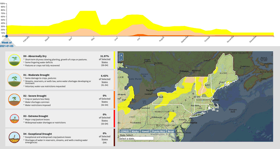
For more details, see the Northeast Drought Early Warning System Dashboard.
Key Points
- Abnormally Dry (D0) conditions stretched from northern Vermont to northern Maine.
- Moderate Drought (D1) remained in northern New Hampshire and Maine.
- Severe Drought (D2) persisted only in northwest Maine.
Current U.S. Drought Monitor map for the Northeast Drought Early Warning System with data valid for January 11, 2022. The U.S. Drought Monitor is updated each Thursday to show the location and intensity of drought across the country.
According to the latest U.S. Drought Monitor:
- Severe drought (D2) exists in 1.51% of the region.
- Moderate drought (D1) conditions exist in 2.11% of the region.
- Abnormally dry (D0) conditions exist in 7.35% of the region.
U.S. Drought Monitor Categories
Current U.S. Drought Monitor map for the Northeast Drought Early Warning System with data valid for January 11, 2022. The U.S. Drought Monitor is updated each Thursday to show the location and intensity of drought across the country.
According to the latest U.S. Drought Monitor:
- Severe drought (D2) exists in 1.51% of the region.
- Moderate drought (D1) conditions exist in 2.11% of the region.
- Abnormally dry (D0) conditions exist in 7.35% of the region.
Current Conditions
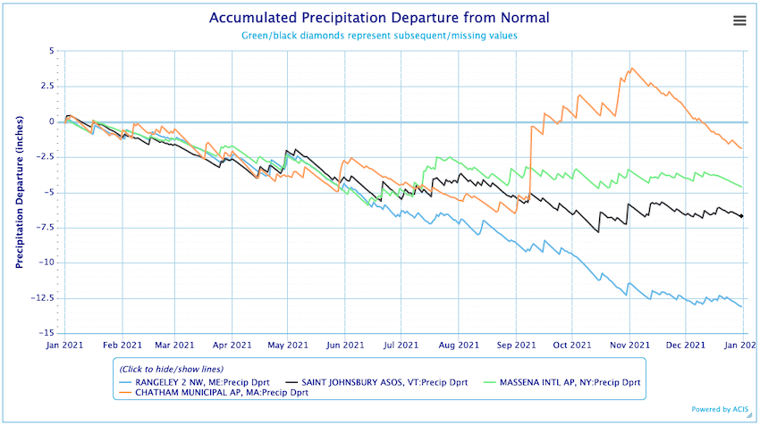
Annual Precipitation Departure from Normal
State-Reported Impacts
States continue to monitor surface and groundwater levels.
Outlooks
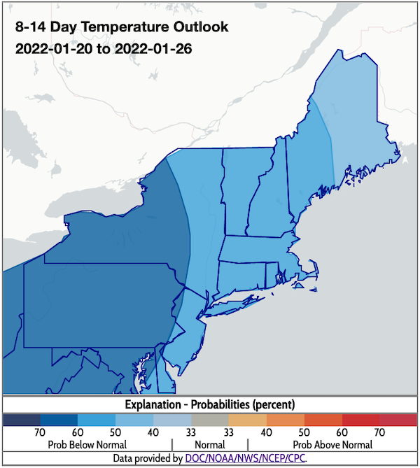
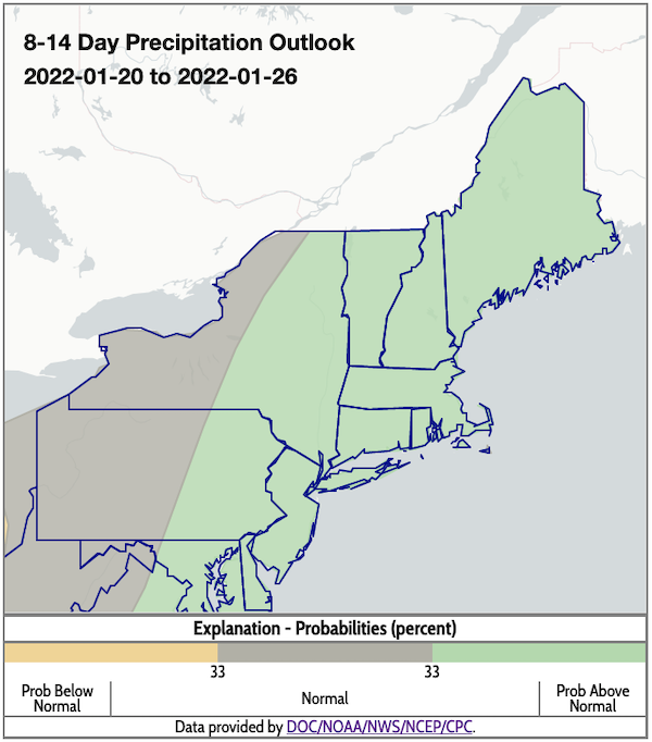
- The 8–14 day outlook favors above-normal precipitation across most of the Northeast DEWS, except western New York, where normal conditions are favored. Below-normal temperatures are likely throughout the region.
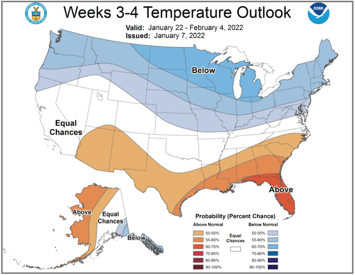
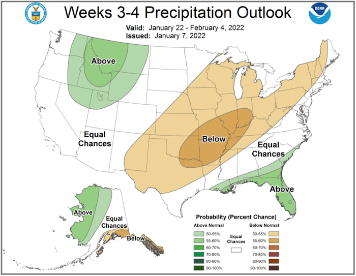
- The 3–4 week outlook favors below-normal temperatures for the entire region and below-normal precipitation for from northern/central New York through western Maine. The rest of the region has equal chances of above- or below-normal precipitation.
8–14 Day Temperature Outlook
8–14 Day Precipitation Outlook
Temperature Outlook Week 3–4
Precipitation Outlook Week 3–4
2021 Drought Recap
Animation: 2021 U.S. Drought Monitor Conditions in the Northeast
- January 12, 2021—Abnormally Dry (D0) conditions and Moderate Drought (D1) were more widespread in the region, but there was no Severe Drought (D2).
- April 13, 2021—Abnormally Dry (D0) conditions and Moderate Drought (D1) expanded significantly through the region.
- June 22, 2021—Severe Drought (D2) appeared in Maine.
- Rain provided relief for southern New England but not the north.
2021 Temperature and Precipitation Highlights
2021 Temperature Conditions
- 2021 was the warmest year on record for Boston, MA, and Providence, RI.
- Boston, MA, and Caribou and Portland, ME, had their warmest June on record.
- Portland, ME, tied its longest streak of consecutive days with a high of at least 95 °F.
- Burlington, VT; Boston, MA; and Concord, NH, set or tied their records for greatest number of June days with a high of at least 95 °F.
- Concord, NH, set its record for the greatest number of June days with a high of at least 90 °F.
- This August was record hot for Caribou, ME, and Buffalo and Syracuse, NY.
- This October was the warmest on record for Syracuse, New York.
- Caribou, ME, had its latest first fall frost on record on October 25.
2021 Precipitation Conditions
- This July was the wettest on record for Concord, NH; Worcester, MA; and Binghamton, NY.
- Multiple climate sites in New York and New England saw their greatest number of July days with measurable precipitation, with Albany, NY, tying its record for all months.
- A few sites set/tied their record for greatest number of July days with at least one inch of precipitation, including Binghamton, NY, which tied its record for all months.
- September 1 became the all-time wettest day on record for LaGuardia Airport, NY, and the wettest September day on record for Bridgeport, CT.
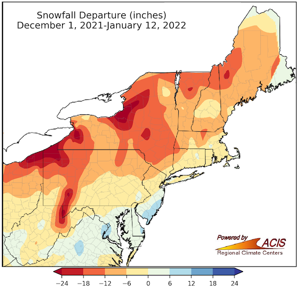
Regional Snowfall Departure: December 1, 2021–January 12, 2022
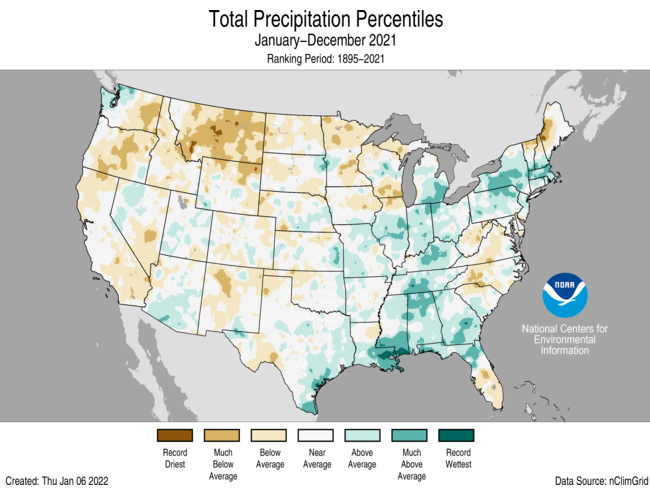
2021 U.S. Total Precipitation Percentiles
- The annual precipitation total for the contiguous U.S. in 2021 was 30.48 inches, 0.54 inches above average, ranking in the middle third of the historical record.
- Despite near-normal precipitation at the national scale, 2021 witnessed several significant events at the regional scale, including an above-average monsoon season across the Southwest and several atmospheric river events along the Pacific Coast.
- Drought remained extensive across much of the western U.S. throughout 2021.
Additional Resources
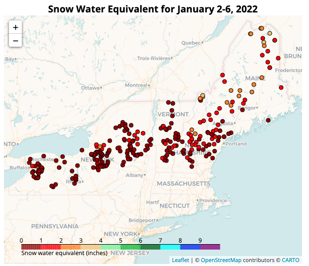
Inaugural New York and New England Snow Survey Map
Bookmark this link for biweekly monitoring of snow water equivalent (SWE).
Other Regional Resources
- Northeast DEWS Dashboard
- Your local National Weather Service office
- NOAA Regional Climate Services Monthly Webinar Series (next webinar is on January 27)
- USDA Northeast Climate Hub
- USGS New England and New York Water Science Centers
Contacts for More Information
Sylvia Reeves
Regional Drought Information Coordinator (Northeast DEWS)
NOAA/CIRES/National Integrated Drought Information System (NIDIS)
Email: sylvia.reeves@noaa.gov
Ellen L. Mecray
Regional Climate Services Director, Eastern Region
NOAA/NESDIS/National Centers for Environmental Information
Email: Ellen.L.Mecray@noaa.gov
Prepared By
Sylvia Reeves
NOAA/National Integrated Drought Information System (NIDIS), CIRES
Samantha Borisoff, Jessica Spaccio, Keith Eggleston, Art DeGaetano
Northeast Regional Climate Center
Ellen Mecray
Regional Climate Services Director, Eastern Region, NOAA
David Hollinger and Maria Janowiak
USDA Climate Hubs
Gardner Bent
USGS New England Water Science Center
In partnership with National Weather Service Offices of the Northeast and State Climate Offices of the Northeast.
This drought early warning update is issued in partnership between the National Oceanic and Atmospheric Administration (NOAA), U.S. Geological Survey, and the U.S. Department of Agriculture (USDA) to communicate concern for drought expansion and intensification within the Northeast U.S. based on recent conditions and the forecasts and outlooks. NIDIS and its partners will issue future Drought Early Warning Updates as conditions evolve.
