New York and New England Remain Drought Free, but Abnormal Dryness Lingers on Long Island.
Key Points:
- New England and New York state are free of drought.
- Abnormally Dry conditions (D0) persist on the eastern two-thirds of Long Island.
- Seasonal snowfall deficits remain a concern for spring fire risk, as well as warm season drought potential.
- The National Significant Wildland Fire Potential Outlook expects near-normal significant fire potential for much of the eastern U.S. in March–June.
Current U.S. Drought Monitor map for the Northeast Drought Early Warning System (DEWS) with data valid for March 21, 2023. The U.S. Drought Monitor is updated each Thursday to show the location and intensity of drought across the country.
According to the latest U.S. Drought Monitor:
- 0.8% of the Northeast is experiencing Abnormally Dry (D0) conditions
- 0% of the Northeast is in drought (D1–D4)
U.S. Drought Monitor Categories
Abnormally Dry (D0)
Abnormally Dry (D0) indicates a region that is going into or coming out of drought. View typical impacts by state.
Moderate Drought (D1)
Moderate Drought (D1) is the first of four drought categories (D1–D4), according to the U.S. Drought Monitor. View typical impacts by state.
Severe Drought (D2)
Severe Drought (D2) is the second of four drought categories (D1–D4), according to the U.S. Drought Monitor. View typical impacts by state.
Extreme Drought (D3)
Extreme Drought (D3) is the third of four drought categories (D1–D4), according to the U.S. Drought Monitor. View typical impacts by state.
Exceptional Drought (D4)
Exceptional Drought (D4) is the most intense drought category, according to the U.S. Drought Monitor. View typical impacts by state.
Current U.S. Drought Monitor map for the Northeast Drought Early Warning System (DEWS) with data valid for March 21, 2023. The U.S. Drought Monitor is updated each Thursday to show the location and intensity of drought across the country.
According to the latest U.S. Drought Monitor:
- 0.8% of the Northeast is experiencing Abnormally Dry (D0) conditions
- 0% of the Northeast is in drought (D1–D4)
Current Conditions
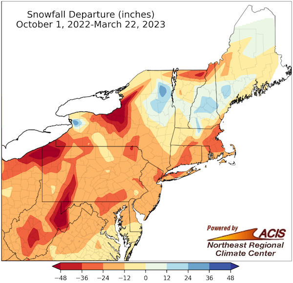
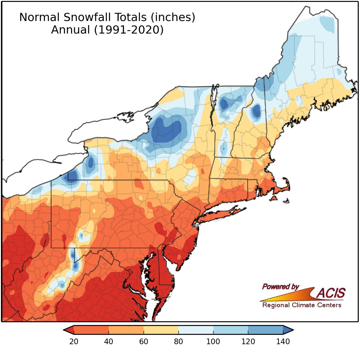
Water Year 2023 Snowfall Departure (Inches)
| Location | Oct. 1, 2022–Mar. 22, 2023 Snowfall (in.) | Normal (in.) | Departure (in.) | Rank (least snowy) |
|---|---|---|---|---|
| Syracuse, NY | 65.3 | 121.4 | -56.1 | 19 |
| Rochester, NY | 49.4 | 95.6 | -46.2 | 13 |
| Boston, MA | 12.4 | 46.0 | -33.6 | 4 |
| Bridgeport, CT | 4.9 | 31.5 | -26.6 | 1* |
| Central Park, NY | 2.3 | 28.6 | -26.3 | 1 |
| LaGuardia Airport, NY | 3.4 | 28.5 | -25.1 | 3 |
| Hartford, CT | 24.2 | 49.1 | -24.9 | |
| Islip, NY | 5.0 | 29.9 | -24.9 | 5 |
| Providence, RI | 11.6 | 35.0 | -23.4 | 6 |
| Kennedy Airport, NY | 2.1 | 24.6 | -22.5 | 2 |
| Worcester, MA | 47.2 | 68.5 | -21.3 | |
| Binghamton, NY | 59.5 | 79.3 | -19.8 | 15 |
| Burlington, VT | 71.7 | 80.0 | -8.3 | |
| Portland, ME | 56.2 | 63.2 | -7.0 | |
| Albany, NY | 54.8 | 55.4 | -0.6 | |
| Concord, NH | 63.7 | 62.5 | 1.2 | |
| Caribou, ME | 115.0 | 104.1 | 10.9 | |
| Buffalo, NY | 133.3 | 90.3 | 43.0 | 5 snowiest |
Snowfall departures in selected cities across the Northeast DEWS region are in the double digits, with Bridgeport, CT and Central Park, NY experiencing their least snowy winters between the dates of October 1 and March 22. Yellow shading indicates record low snowfall, while blue indicates locations with above-normal snowfall. *Bridgeport, CT is missing snow data on 3/14. Source: ACIS.
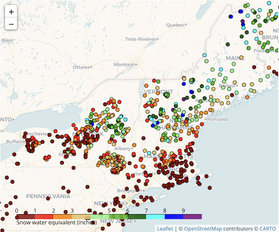
Snow Water Equivalent for March 12–16, 2023
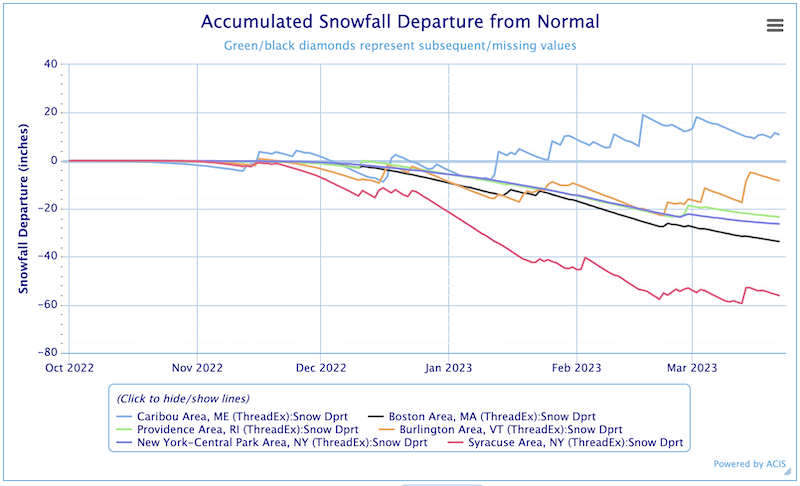
Accumulated Snowfall Departure from Normal
State-Reported Conditions and Impacts
Connecticut
- Connecticut Drought Information Center
- Impacts:
- March 20, 2023: CT Insider – High Risk of Brush Fires for the First Day of Spring
- March 2022: Department of Energy and Environmental Protection – Forest Fire Weather Information Page
Maine
- Maine Drought Task Force
- Impacts:
- March 27, 3-4 pm: Mitchell Center/University of Maine - Talk: Dealing with Drought/Farmers’ Needs (Open to New Hampshire residents as well)
- March 7, 2023: Sun Journal – Maple Syrup Producers Optimistic About Sap Production After Several Years of Drought Events
- March 3, 2023: News Center Maine – Groundwater Levels Replenished
Massachusetts
- Massachusetts Drought Management Task Force
- Impacts:
- March 23, 2023: Boston Herald – Elevated Fire Weather Concerns for the Start of Spring
- February 28, 2023: Telegram & Gazette – Worcester’s Lakes and Ponds Water Quality Report
New Hampshire
New York
- New York State Department of Environmental Conservation (DEC): Drought
- Impacts:
- March 17, 2023: Dept. of Environmental Conservation – Start of Prescribed Fire Season
- March 9, 2023: Dept. of Environmental Conservation – Reminder: Brush Burning Prohibition
Rhode Island
- Rhode Island Water Resources Board: Drought Management Program
- Impacts:
- March 16, 2023: The Providence Journal – National Weather Service: Precipitation Monitors Needed (See CoCoRaHS request for volunteers below.)
Vermont
- Vermont Agency of Natural Resources, Department of Environmental Conservation: Drought and Other Hazards
- Impacts:
- March 13, 2023: Burlington Free Press – Maple Syrup
Northeast
Volunteers are needed to measure precipitation! CoCoRaHS (the Community Collaborative Rain, Hail, and Snow Network) is a non-profit, community-based network of volunteer weather observers of all ages and backgrounds who measure and report precipitation. These data help improve the accuracy of weather forecasts, contribute to real-time drought and flood monitoring, are used in research applications, and so much more. Ready to help? Go to www.cocorahs.org and click the “Join CoCoRaHS” button in the upper right corner.
Find additional impacts through the National Drought Mitigation Center’s Drought Impact Reporter.
Find local drought information by address, city or zip code on Drought.gov.
Outlooks
8–14 Day Temperature and Precipitation Outlooks
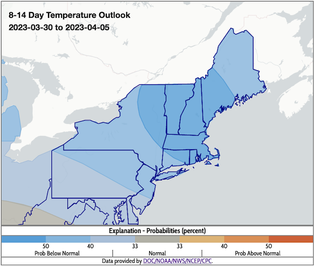
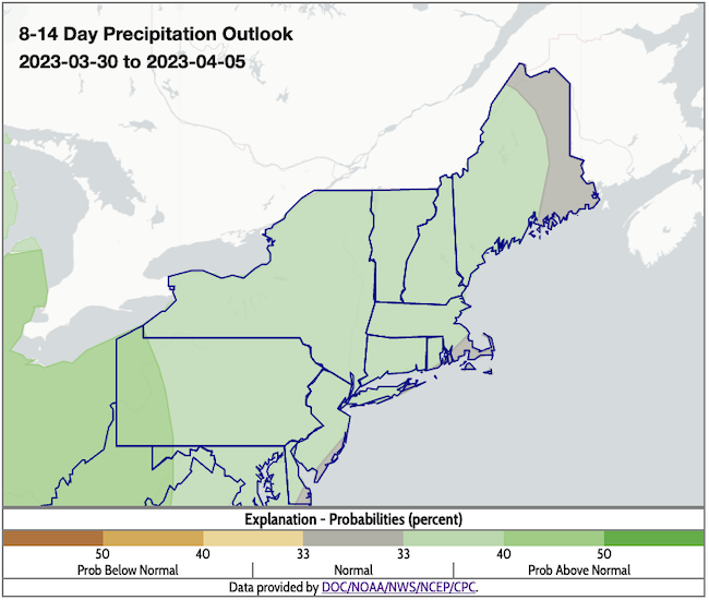
- According to the Climate Prediction Center's 8–14 day outlooks (valid March 30–April 5):
- Temperatures across the region are expected to be below normal for the period (offering the possibility for some improvement to the snowfall deficits).
- Precipitation is expected to be above normal for all but the extreme northernmost portions of Maine. With a low snow winter almost in the record books, this could help reduce the brush fire risk for a few weeks.
Week 3–4 Temperature and Precipitation Outlooks
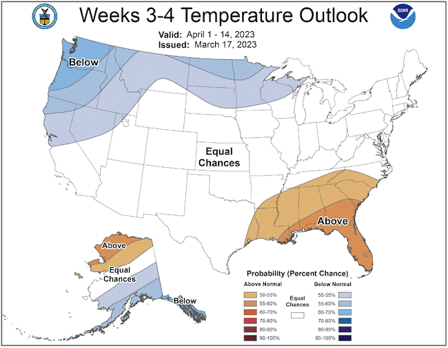
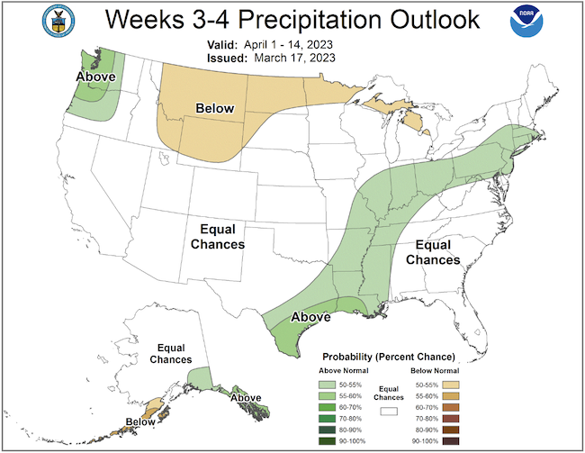
According to the week 3–4 outlook (valid April 1–14, 2023):
- Lower confidence and predictability exists with the transition to spring, but there are equal chances for above- or below-normal temperatures.
- Slightly above-normal precipitation could be expected for southern New England and southeastern New York, with equal chances for above- or below-normal precipitation elsewhere in the region. Lower outlook confidence remains the key point as spring conditions are defined by the El Niño-Southern Oscillation (ENSO) transition (La Niña to Neutral and then a possible El Niño status by late spring or summer).
- Longer range models and statistical guidance are mixed in terms of expected outcomes for weather patterns, temperature, and precipitation.
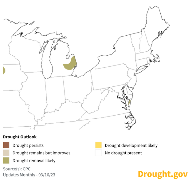
U.S. Seasonal Drought Outlook: March 16–June 30, 2023
There is moderate confidence that the Northeast will remain drought free for the period due to shorter-range forecasts and outlooks for cooler and wetter conditions.
What We Are Watching
- USGS 2022 Drought in New England Report
- The U.S. Geological Survey New England Water Science Center recently published a Scientific Investigations Report entitled “2022 Drought in New England,” which documents the hydrologic conditions during the short but intense drought last summer.
- USGS will host a webinar on Friday, April 7 from 12:00-1:00 pm where the authors of the report will present on the hydrologic conditions documented in the report, from both a regional and state-wide perspective, highlighting record low streamflow and groundwater levels that occurred at USGS stream gauges and monitoring wells. Join the meeting.
- Check out this recent Axios article: "Winters Warming Faster Than Our Summers"
- Save the date for the NIHHIS annual meeting on April 25–27, 2023.
- NIDIS is hosting the 2nd National Flash Drought Workshop May 2–4, 2023 in Boulder, Colorado. Register here.
- Coming Soon: State of the Science Synthesis On Transformational Drought. This research is concluding, soon with project papers and a report in progress.
- Save the date for the 2023 Northeast-Midwest Prescribed Fire Workshop on August 29–31 in Madison, Wisconsin.
Featured Resources
- American Water Works Association: Designing and Evaluating Effective and Ongoing Drought Communication
- National Significant Wildland Fire Potential Outlook: March–June 2023
Additional Resources
- Look back at previous Northeast DEWS Drought Status Updates
- Your local National Weather Service office
- NOAA Regional Climate Services Monthly Webinar Series (next webinar is on March 30)
- USDA Northeast Climate Hub
- USGS New England and New York Water Science Centers
Contacts for More Information
Sylvia Reeves
Regional Drought Information Coordinator (Northeast DEWS)
NOAA/CIRES/National Integrated Drought Information System (NIDIS)
Email: sylvia.reeves@noaa.gov
Ellen L. Mecray
Regional Climate Services Director, Eastern Region
NOAA/NESDIS/National Centers for Environmental Information
Email: Ellen.L.Mecray@noaa.gov
Prepared By
Sylvia Reeves
NOAA/National Integrated Drought Information System (NIDIS), CIRES
Samantha Borisoff, Jessica Spaccio, Keith Eggleston, Art DeGaetano
Northeast Regional Climate Center
Ellen Mecray
Regional Climate Services Director, Eastern Region, NOAA
Gardner Bent
USGS New England Water Science Center
In partnership with National Weather Service Offices of the Northeast and State Climate Offices of the Northeast.
This drought status update is issued in partnership between the National Oceanic and Atmospheric Administration (NOAA), U.S. Geological Survey, and the U.S. Department of Agriculture (USDA) to communicate concern for drought expansion and intensification within the Northeast U.S. based on recent conditions and the forecasts and outlooks. NIDIS and its partners will issue future drought status updates as conditions evolve.
