Drought Continued to Intensify with Prolonged Dryness
Key Points
- Drought continued to expand and intensify throughout September, with roughly one-third of the Northeast experiencing Severe or Extreme Drought (D2-D3). Almost the entire Northeast (99.97%) is experiencing Abnormally Dry conditions or drought (D0-D3). In terms of severity and coverage, Vermont is experiencing its worst drought conditions since the U.S. Drought Monitor began in 2000.
- Impacts are widespread, including water supply and quality issues, increased wildfires, crop losses/low yields, and livestock forage concerns.
- Areas experiencing the worst drought conditions, such as central portions of Vermont, New Hampshire, and Maine, received precipitation in the past week. However, additional precipitation will be needed to overcome the accrued deficits.
- Warm and dry conditions returned to the region, and outlooks indicate this trend will likely continue into October.
This update is based on data available as of Tuesday, September 30, 2025 at 10:00 a.m. ET. We acknowledge that conditions are evolving.
The U.S. Drought Monitor depicts the location and intensity of drought across the country using 5 classifications: Abnormally Dry (D0), showing areas that may be going into or are coming out of drought, and four levels of drought (D1–D4).
The U.S. Drought Monitor is a joint effort of the National Drought Mitigation Center, U.S. Department of Agriculture, and National Oceanic and Atmospheric Administration.
A drought index combines multiple drought indicators (e.g., precipitation, temperature, soil moisture) to depict drought conditions. For some products, like the U.S. Drought Monitor, authors combine their analysis of drought indicators with input from local observers. Other drought indices, like the Standardized Precipitation Index (SPI), use an objective calculation to describe the severity, location, timing, and/or duration of drought.
Learn MorePeriods of drought can lead to inadequate water supply, threatening the health, safety, and welfare of communities. Streamflow, groundwater, reservoir, and snowpack data are key to monitoring and forecasting water supply.
Learn MoreDrought can reduce the water availability and water quality necessary for productive farms, ranches, and grazing lands, resulting in significant negative direct and indirect economic impacts to the agricultural sector. Monitoring agricultural drought typically focuses on examining levels of precipitation, evaporative demand, soil moisture, and surface/groundwater quantity and quality.
Learn MoreU.S. Drought Monitor
D0 - Abnormally Dry
Abnormally Dry (D0) indicates a region that is going into or coming out of drought, according to the U.S. Drought Monitor. View typical impacts by state.
D1 – Moderate Drought
Moderate Drought (D1) is the first of four drought categories (D1–D4), according to the U.S. Drought Monitor. View typical impacts by state.
D2 – Severe Drought
Severe Drought (D2) is the second of four drought categories (D1–D4), according to the U.S. Drought Monitor. View typical impacts by state.
D3 – Extreme Drought
Extreme Drought (D3) is the third of four drought categories (D1–D4), according to the U.S. Drought Monitor. View typical impacts by state.
D4 – Exceptional Drought
Exceptional Drought (D4) is the most intense drought category, according to the U.S. Drought Monitor. View typical impacts by state.
The U.S. Drought Monitor depicts the location and intensity of drought across the country using 5 classifications: Abnormally Dry (D0), showing areas that may be going into or are coming out of drought, and four levels of drought (D1–D4).
The U.S. Drought Monitor is a joint effort of the National Drought Mitigation Center, U.S. Department of Agriculture, and National Oceanic and Atmospheric Administration.
This U.S. Drought Monitor and change maps are released every Thursday morning, with data valid through Tuesday at 7 a.m. EST.
A drought index combines multiple drought indicators (e.g., precipitation, temperature, soil moisture) to depict drought conditions. For some products, like the U.S. Drought Monitor, authors combine their analysis of drought indicators with input from local observers. Other drought indices, like the Standardized Precipitation Index (SPI), use an objective calculation to describe the severity, location, timing, and/or duration of drought.
Learn MorePeriods of drought can lead to inadequate water supply, threatening the health, safety, and welfare of communities. Streamflow, groundwater, reservoir, and snowpack data are key to monitoring and forecasting water supply.
Learn MoreDrought can reduce the water availability and water quality necessary for productive farms, ranches, and grazing lands, resulting in significant negative direct and indirect economic impacts to the agricultural sector. Monitoring agricultural drought typically focuses on examining levels of precipitation, evaporative demand, soil moisture, and surface/groundwater quantity and quality.
Learn MoreCurrent Conditions and Impacts in the Northeast
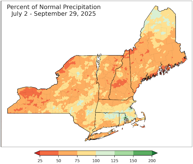
- Below-normal precipitation continued through September, with much of the region receiving less than 50% of normal precipitation during the past 90 days. A weather system brought ~1-3 inches of precipitation to the region September 23-25, but more precipitation is needed to significantly improve drought conditions and reduce impacts.
- According to the NOAA National Centers for Environmental Information, New Hampshire had its driest summer (June-August) and second driest August on record, while Vermont had its driest August and second driest summer on record (period of record 1895-present).
- Drought expanded in the Northeast.
- Extreme Drought (D3) expanded to cover ~33% of New Hampshire and ~24% of Vermont—the largest D3 coverage ever experienced in these states since the U.S. Drought Monitor began in 2000.
- Extreme Drought (D3) was also introduced to portions of southern Maine.
- Severe Drought (D2) expanded throughout Maine, New Hampshire, Vermont, and eastern New York, while Moderate Drought (D1) expanded further across northern Maine, eastern and western New York, northern Massachusetts, and along the coast of Connecticut and Rhode Island.
- New Hampshire activated its Drought Management Team. The New York State Department of Environmental Conservation upgraded the Adirondack and Southern Tier regions of the state to a Drought Warning, while much of the rest of the state remained in a Drought Watch.
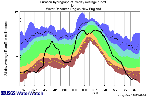
- Record-low streamflows and groundwater levels continued to be reported across the Northeast, causing a myriad of impacts. (View groundwater data for New York and New England.)
- Numerous wells ran dry across Vermont and New Hampshire, prompting citizens to ask for new wells to be drilled. Many well drillers are no longer taking new customers to drill new wells until spring due to the high number of requests.
- Moriah, New York declared a state of emergency due to critically low water supply.
- Hydropower generation slowed across northern New England.
- A widespread harmful algal bloom (HAB) developed in the Hudson River near Kingston, New York, creating hazardous swimming conditions and prompting a warning to citizens on private water supplies to avoid drinking the surface water. High sodium levels were reported in tap water throughout the Hudson River Valley.
- According to the New Hampshire Department of Environmental Services, Lake Winnipesaukee is nearly 8 inches below normal for late September, and Lake Sunapee is 17.5 inches below full pond. Ninety-two public water systems have outdoor watering restrictions, which impact about 200,000 people.
- Impacts to agriculture are mounting, and producers anticipate yield losses.
- Significant crop losses and lower yields are expected across northern New England, particularly for blueberries, cranberries, corn, and potatoes.
- The hay crop took a big hit across northern New England this growing season, with lower yields and fewer cuts. Many producers are already experiencing hay shortages.
- In New York, producers reported the drought is impacting the planting of cover crops and winter grains. There is little water available in drying streams and ponds for irrigation in some places, causing producers to pay for hydrant access.
- Wildfire activity was above-normal during the late summer, and high fire danger continued into September for much of the Northeast.
- New Hampshire and Vermont both implemented statewide burn bans on September 22, 2025.
- According to the Maine Forest Service, September wildfire activity has been above normal, though not as active as August. Recent rainfall reduced the availability of wildland fire fuels.
- There was a recent uptick in brush fires in Massachusetts.
Extreme Dryness Over the Past 90 Days
Runoff at Historic Lows in New England
Drought Impacts Continue to Worsen
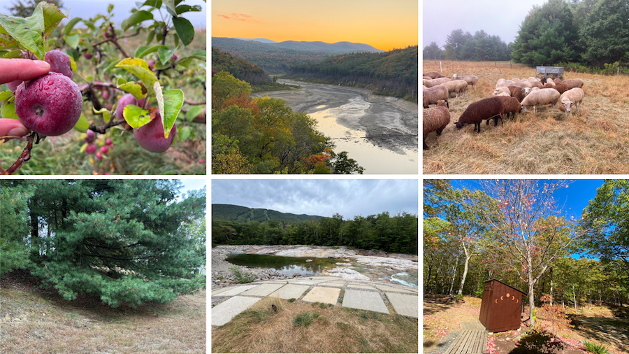
Top row from left to right: small apples due to lack of rainfall in Addison County, Vermont; low water levels at Ball Mountain Lake in Windham County, Vermont; and feeding hay early in Caledonia County, Vermont.
Bottom row from left to right: dry grass in Dutchess County, New York; East Branch Pemigewasset River during drought near Lincoln, New Hampshire; early leaf drop in Grafton County, New Hampshire. Bottom left photo courtesy of N. Umphlett. Bottom center photo courtesy of USGS. All other photos are from Condition Monitoring Observer Reports (CMOR).
Outlooks and Potential Impacts for the Northeast
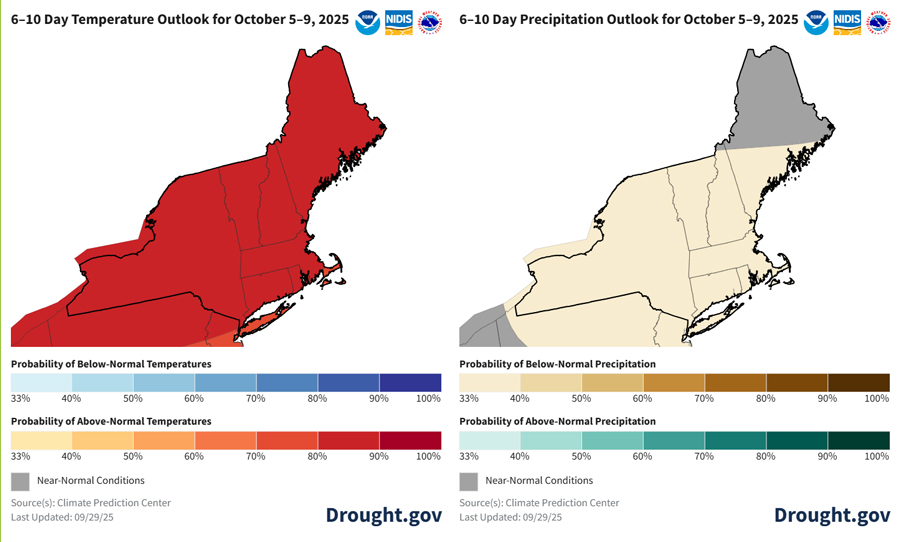
- National Weather Service (NWS) forecasts favor a return to warm and dry conditions.
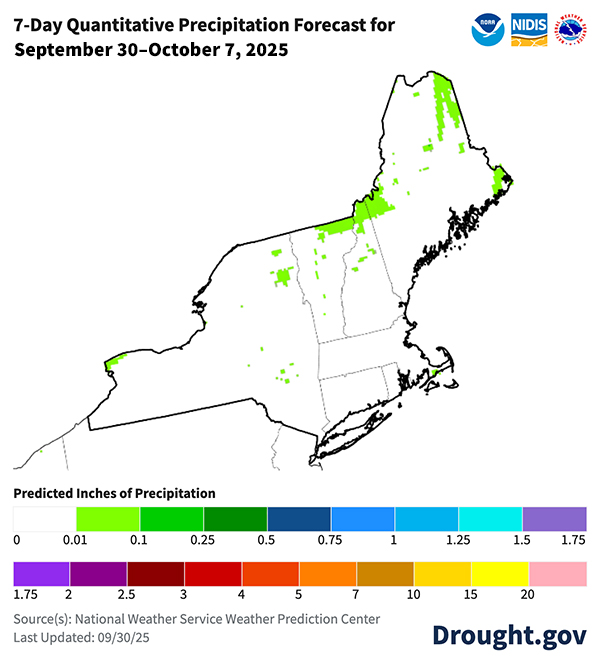
- The NWS Weather Prediction Center’s 7-Day Quantitative Precipitation Forecast forecasts very little precipitation in the Northeast over the next week. The NWS Climate Prediction Center’s 6-10 day outlook favors above-normal temperatures for the Northeast. Below-normal precipitation is favored for most of the Northeast, except for northern and central Maine, where outlooks favor near-normal precipitation.
- The three-month outlook for October-December favors above-normal temperatures and equal chances of above-, below-, and near-normal precipitation for the entire region.
- Given the return of warm and dry conditions, the region should expect little improvement in drought conditions.
- Streamflows and groundwater levels are likely to remain low with ongoing dry conditions. Follow local officials for information on water restrictions, conservation measures, and water quality alerts.
- The availability of adequate winter feed for livestock due to poor summer pasture conditions and low hay yields is a major concern across Maine, New Hampshire, and Vermont. In Vermont, sugar bush were struggling, which could be a problem in the spring when maple syrup is harvested. Dry ground may also impact field preparations next year.
- Peak fall foliage season in New England is expected to come early and be brief this year due to drought stress on trees and early leaf drop.
- Ongoing dry conditions and early leaf drop are setting the stage for an active fire season this fall.
- Vermont requests citizens report dry wells, water shortages, and other drought impacts.
Little to No Precipitation Expected in the Next Week
6-10 Day Outlook Favors Warm and Dry Conditions
Additional Resources
Regional Resources
- Northeast DEWS Dashboard
- Weekly Northeast Drought Update from the Northeast Regional Climate Center
- Register for the next Northeast Regional Climate Center monthly webinar on Thursday, October 30 at 9:30 a.m. ET.
- View or submit Condition Monitoring Observer Reports (CMOR)
- The U.S. Drought Monitor triggers eligibility for the USDA Livestock Forage Disaster Program. Find your local service center to connect with a Farm Service Agency representative if you are a producer impacted by drought.
State Resources
- Connecticut: Connecticut Drought Information Center
- Maine: Maine Drought Task Force Dry Well Survey and Maine Farmers Drought Relief Fund
- Massachusetts: Drought Status
- New Hampshire: Department of Environmental Services Drought Webpage
- New York: Department of Environmental Conservation Current Drought Conditions
- Rhode Island: State Climate Office Weekly Drought Discussion and Rhode Island Water Resources Board Drought Monitoring Dashboard
- Vermont: Agency of Natural Resources Current Fire Danger Forecast; Vermont Department of Environmental Conservation Drought Reports; Vermont Department of Health Cyanobacteria (Blue-Green Algae) Tracker; and Vermont Drinking Water Drought Reporter.
Prepared By
Crystal Stiles
Cooperative Institute for Research in Environmental Sciences (CIRES) at the University of Colorado Boulder | NOAA National Integrated Drought Information System (NIDIS)
Samantha Borisoff, Art DeGaetano, Keith Eggleston, Jessica Spaccio, and Natalie Umphlett
Northeast Regional Climate Center
This Drought Status Update is issued in partnership between the National Oceanic and Atmospheric Administration (NOAA), the Northeast Regional Climate Center, the U.S. Geological Survey, and state climatologists to communicate a potential area of concern for drought expansion and/or development within the Northeast region based on recent conditions and the upcoming forecast.
A special thank you to the state climate offices, state partners, and National Weather Service offices in the Northeast region for providing local information on drought conditions and impacts included in this Drought Status Update.
NIDIS and its partners will issue future Drought Status Updates as conditions evolve.
