Drought Conditions Remain, But Improve; Hydrologic Impacts Expected to Linger into Spring
Key Points
- Several rounds of precipitation over the last few weeks relieved drought in many areas of the Northeast, particularly in northern New England, where the majority of Extreme Drought (D3) was removed. However, drought conditions worsened in northern and southern areas of Maine, where less precipitation fell.
- Since the growing season ended, hydrologic impacts are now driving the drought. The primary impacts are low surface and groundwater supplies, and dry wells are an ongoing issue in northern New England. With well drillers in high demand and soils freezing soon, there is concern that some households in Maine, New Hampshire, and Vermont may not have water entering winter. State agencies advised against drinking water from roadside springs as an alternate source, which can lead to health issues.
- Once soils freeze, moisture (or lack of moisture) will be locked in. Drought conditions are expected to change very little across northern New England over the next few months. While an abundant snowpack would improve water supplies in the spring, it will not do much to lessen impacts during the winter. This means current hydrologic impacts may linger into spring.
- Agricultural producers are now assessing losses from the drought this year. Preliminary estimates include a $13.5 million loss to agriculture in Vermont and $30 million and $10 million losses to Maine’s blueberry and apple industries, respectively. Long-term drought impacts to berries and orchard fruit may emerge during the next growing season in northern New England.
This update is based on data available as of Thursday, November 20, 2025 at 10:00 a.m. ET. We acknowledge that conditions are evolving.
The U.S. Drought Monitor depicts the location and intensity of drought across the country using 5 classifications: Abnormally Dry (D0), showing areas that may be going into or are coming out of drought, and four levels of drought (D1–D4).
The U.S. Drought Monitor is a joint effort of the National Drought Mitigation Center, U.S. Department of Agriculture, and National Oceanic and Atmospheric Administration.
A drought index combines multiple drought indicators (e.g., precipitation, temperature, soil moisture) to depict drought conditions. For some products, like the U.S. Drought Monitor, authors combine their analysis of drought indicators with input from local observers. Other drought indices, like the Standardized Precipitation Index (SPI), use an objective calculation to describe the severity, location, timing, and/or duration of drought.
Learn MorePeriods of drought can lead to inadequate water supply, threatening the health, safety, and welfare of communities. Streamflow, groundwater, reservoir, and snowpack data are key to monitoring and forecasting water supply.
Learn MoreDrought can reduce the water availability and water quality necessary for productive farms, ranches, and grazing lands, resulting in significant negative direct and indirect economic impacts to the agricultural sector. Monitoring agricultural drought typically focuses on examining levels of precipitation, evaporative demand, soil moisture, and surface/groundwater quantity and quality.
Learn MoreU.S. Drought Monitor
D0 - Abnormally Dry
Abnormally Dry (D0) indicates a region that is going into or coming out of drought, according to the U.S. Drought Monitor. View typical impacts by state.
D1 – Moderate Drought
Moderate Drought (D1) is the first of four drought categories (D1–D4), according to the U.S. Drought Monitor. View typical impacts by state.
D2 – Severe Drought
Severe Drought (D2) is the second of four drought categories (D1–D4), according to the U.S. Drought Monitor. View typical impacts by state.
D3 – Extreme Drought
Extreme Drought (D3) is the third of four drought categories (D1–D4), according to the U.S. Drought Monitor. View typical impacts by state.
D4 – Exceptional Drought
Exceptional Drought (D4) is the most intense drought category, according to the U.S. Drought Monitor. View typical impacts by state.
The U.S. Drought Monitor depicts the location and intensity of drought across the country using 5 classifications: Abnormally Dry (D0), showing areas that may be going into or are coming out of drought, and four levels of drought (D1–D4).
The U.S. Drought Monitor is a joint effort of the National Drought Mitigation Center, U.S. Department of Agriculture, and National Oceanic and Atmospheric Administration.
This U.S. Drought Monitor and change maps are released every Thursday morning, with data valid through Tuesday at 7 a.m. EST.
A drought index combines multiple drought indicators (e.g., precipitation, temperature, soil moisture) to depict drought conditions. For some products, like the U.S. Drought Monitor, authors combine their analysis of drought indicators with input from local observers. Other drought indices, like the Standardized Precipitation Index (SPI), use an objective calculation to describe the severity, location, timing, and/or duration of drought.
Learn MorePeriods of drought can lead to inadequate water supply, threatening the health, safety, and welfare of communities. Streamflow, groundwater, reservoir, and snowpack data are key to monitoring and forecasting water supply.
Learn MoreDrought can reduce the water availability and water quality necessary for productive farms, ranches, and grazing lands, resulting in significant negative direct and indirect economic impacts to the agricultural sector. Monitoring agricultural drought typically focuses on examining levels of precipitation, evaporative demand, soil moisture, and surface/groundwater quantity and quality.
Learn MoreCurrent Conditions and Impacts in the Northeast
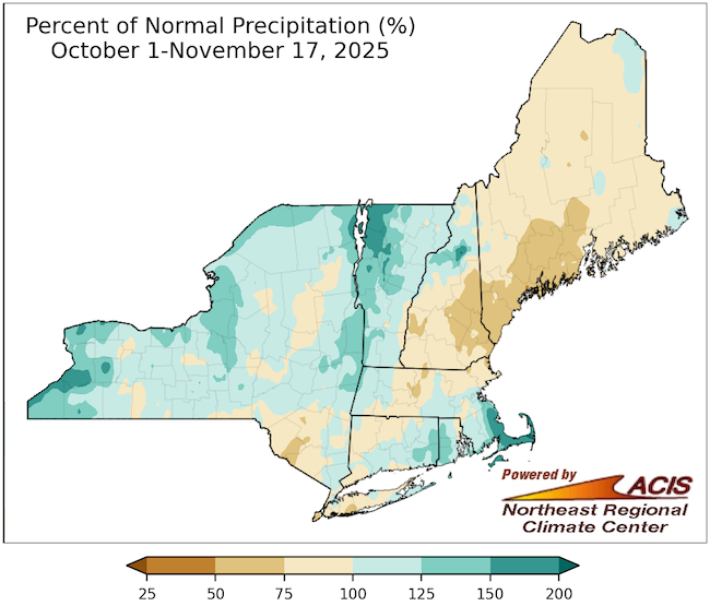
- Precipitation has varied widely across the Northeast since the beginning of October. In late October and early to mid-November, precipitation fell across Vermont, New York, Connecticut, Rhode Island, and eastern Massachusetts. Some of these areas received up to 200% of normal precipitation since the beginning of October.
- However, dryness persisted in parts of Maine, New Hampshire, and central Massachusetts, where precipitation since October 1 was only 50-90% of normal.
- Overall, drought conditions intensified across parts of the region the first week of October and remained for the month, while other areas of the region saw improvements. By the first week of November, widespread improvements were made on the U.S. Drought Monitor. From October 7 to November 18:
- Extreme Drought (D3) improved across northern New England, except for the southern part of coastal Maine.
- Severe Drought (D2) improved in New York, Cape Cod, and Nantucket but expanded in northern Maine.
- Moderate Drought (D1) improved along southern New England’s coastal areas, and portions of central New York.
- Abnormally Dry (D0) conditions were removed throughout several areas of New York, Massachusetts, and Connecticut. Rhode Island is completely free of dryness and drought except for Block Island, which is Abnormally Dry (D0).
- Recent precipitation and the arrival of the end of the growing season improved drought impacts in parts of the region.
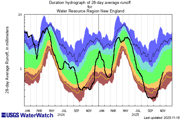
- Streamflows and topsoil experienced modest recharge across some areas of the Northeast, such as Lake Champlain in Vermont and New York. According to the U.S. Geological Survey, 28-day average runoff for New England rebounded almost to normal.
- All of New York’s drought regions that were previously in a Drought Warning improved to a Drought Watch. Conservation orders were lifted in the towns of Ripley and Moriah, New York. Lake effect rainfall was largely responsible for drought improvement and removal in western New York.
- Fire danger decreased across the region, and concerns for an active fall wildfire season declined. The statewide burn bans were lifted for Vermont and New Hampshire in October.
- Despite recent precipitation, drought impacts are still occurring:
- Several rivers in Maine hit record lows in October.
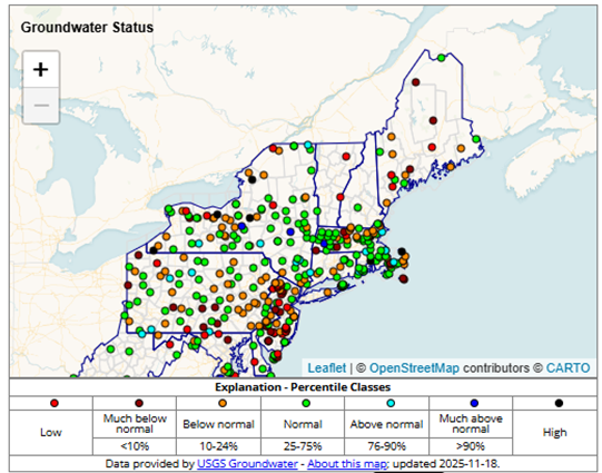
- Sub-soil moisture and groundwater deficits remain throughout many parts of the Northeast.
- Dry wells are an ongoing problem in Maine, New Hampshire, and Vermont.
- Now that the growing season has ended, agricultural producers are assessing losses. According to the Vermont 2025 Agriculture Drought Impact Survey, producers estimated approximately $13.5 million in total losses, and 59% of 167 respondents described this drought as “the worst I’ve ever seen.” The Wild Blueberry Commission of Maine estimates that the state’s blueberry industry lost $30 million due to the drought this year, while the Maine Pomological Society estimates apple losses at about $10 million.
- The Vermont Agriculture Secretary requested a statewide secretarial disaster designation from the U.S. Department of Agriculture (USDA), and several counties in Vermont, New Hampshire, and Maine are eligible for federal assistance programs from the USDA.
Variable Precipitation Since Beginning of October
Runoff Is Improving
Groundwater Deficits Remain
Outlooks and Potential Impacts for the Northeast
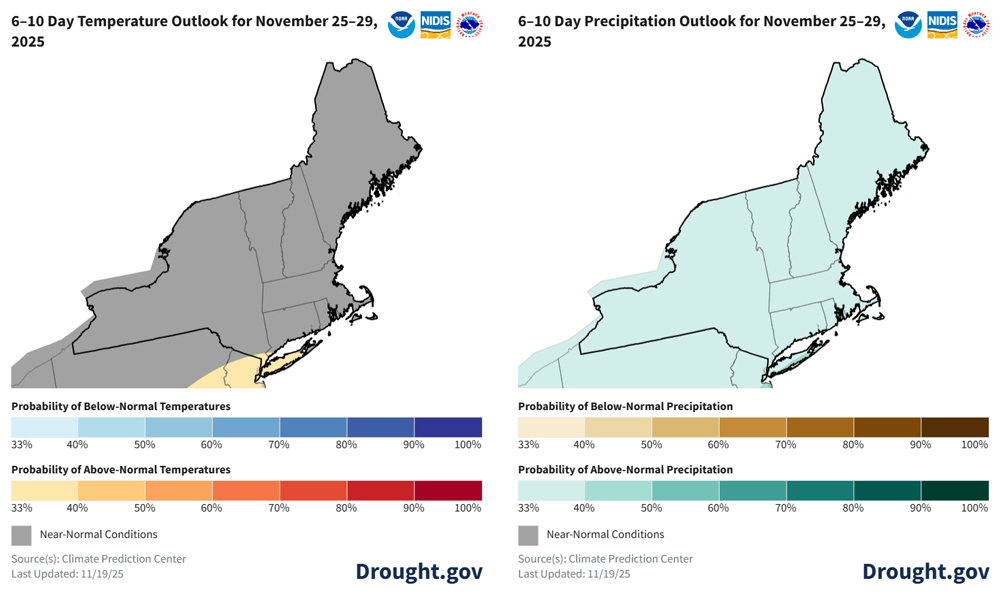
- The National Weather Service Climate Prediction Center’s 6–10 day outlook favors near-normal temperatures for the Northeast, with the exception of Long Island, where above-normal temperatures are slightly favored. Above-normal precipitation is favored for the entire region.
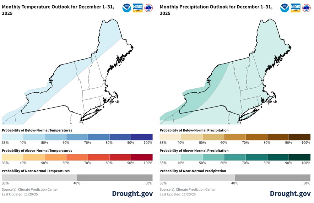
- The one-month outlook for December favors below-normal temperatures for the northern tier of the region, and equal chances of above-, below-, and near-normal temperatures elsewhere. Above-normal precipitation is favored for the entire region, especially in northern and western New York.
- The three-month outlook for December–February favors above-normal temperatures for southern New England and New York, and equal chances of above-, below-, and near-normal temperatures for the rest of the region. There are equal chances of above-, below-, and near-normal precipitation for the Northeast, except for extreme western New York, where above-normal precipitation is slightly favored.
- Soils will freeze over the winter in northern New England, locking in moisture that is in the ground. Until spring, drought conditions are not expected to change much, and hydrologic impacts are expected to remain.
- With well drillers in high demand and soils freezing soon, a primary concern is some households in Maine, New Hampshire, and Vermont may not have water entering winter. State agencies advised against drinking water from roadside springs as an alternate source, which may cause health issues.
- Amid poor summer pasture conditions and low hay yields, many agricultural producers are still concerned about availability of adequate winter feed for livestock across Maine, New Hampshire, and Vermont. In Vermont, sugar bush struggled this year, which could reduce the maple syrup harvest in spring. The impact of the summer and fall drought on orchard trees and berries may linger into the next growing season. Dry ground may also impact field preparations next year.
- Ski resorts in the Northeast expressed concern about having enough water to generate snow this winter.
Wet Conditions Favored in the Next 6–10 Days
Wet Conditions Expected to Continue into December
Additional Resources
Regional Resources
- Northeast DEWS Dashboard
- Weekly Northeast Drought Update from the Northeast Regional Climate Center
- Register for the next Northeast Regional Climate Center monthly webinar on Thursday, December 18 at 9:30 a.m. ET.
- View or submit Condition Monitoring Observer Reports (CMOR)
- The U.S. Drought Monitor triggers eligibility for the USDA Livestock Forage Disaster Program. Find your local service center to connect with a Farm Service Agency representative if you are a producer impacted by drought.
State Resources
- Connecticut:
- Connecticut Drought Information Center
- Maine:
- Monitoring: Maine Drought Task Force Dry Well Survey and Reports
- Disaster Assistance and Recovery: Maine Farmers Drought Relief Fund
- Massachusetts:
- New Hampshire:
- Department of Environmental Services Drought Webpage and Dry Well Report Form
- New York:
- Department of Environmental Conservation Current Drought Conditions and Dry Water Well Reporting Form
- Rhode Island:
- State Climate Office Weekly Drought Discussion
- Rhode Island Water Resources Board Drought Monitoring Dashboard
- Vermont:
- Agency of Natural Resources Current Fire Danger Forecast; Vermont Department of Environmental Conservation Drought Reports; Vermont Department of Health Cyanobacteria (Blue-Green Algae) Tracker; Vermont Drinking Water Drought Reporter; and Vermont Agency of Agriculture, Food & Markets 2025 Agriculture Drought Impact Survey
Prepared By
Crystal Stiles
Cooperative Institute for Research in Environmental Sciences (CIRES) at the University of Colorado Boulde, NOAA National Integrated Drought Information System (NIDIS)
Samantha Borisoff, Art DeGaetano, Keith Eggleston, Jessica Spaccio, and Natalie Umphlett
Northeast Regional Climate Center
This Drought Status Update is issued in partnership between the National Oceanic and Atmospheric Administration (NOAA) National Integrated Drought Information System (NIDIS) and National Weather Service, the Northeast Regional Climate Center, the U.S. Geological Survey, and state climatologists to communicate a potential area of concern for drought expansion and/or development within the Northeast region based on recent conditions and the upcoming forecast. NIDIS is an interagency program within the Climate Program Office, which is part of NOAA's Office of Oceanic and Atmospheric Research.
A special thank you to the state climate offices, state partners, and National Weather Service offices in the Northeast region for providing local information on drought conditions and impacts included in this Drought Status Update.
NIDIS and its partners will issue future Drought Status Updates as conditions evolve.


