Drought Impacts Continue To Expand and Intensify.
For more details, see the Northeast Drought Early Warning System Dashboard.
Key Points
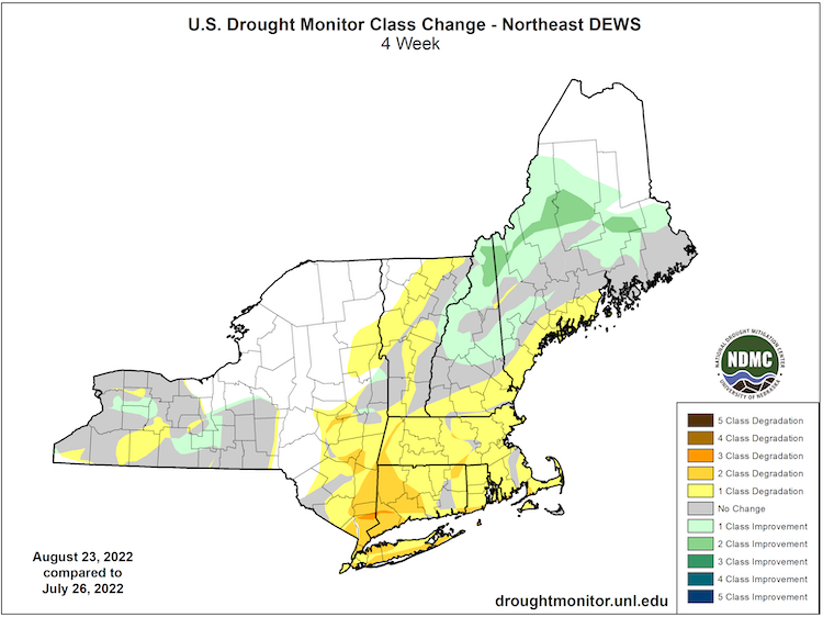
- Extreme Drought (D3) expanded to cover most of Rhode Island and eastern Connecticut, and expanded in Massachusetts.
- Extreme Drought (D3) also pushed into a small portion of southern New Hampshire.
- Severe Drought (D2) expanded across most of Connecticut and Massachusetts and into New Hampshire and southern Vermont, as well as southern Long Island.
- Moderate Drought (D1) expanded in eastern New York, Long Island, and Vermont.
- Some areas of Maine saw rain and conditions improve, while other areas missed out and Moderate Drought (D1) expanded.
Current U.S. Drought Monitor map for the Northeast Drought Early Warning System with data valid for August 23, 2022. The U.S. Drought Monitor is updated each Thursday to show the location and intensity of drought across the country.
According to the latest U.S. Drought Monitor:
- Extreme drought (D3) conditions exist in 4.45% of the region.
- Severe drought (D2) conditions exist in 12.98% of the region.
- Moderate drought (D1) conditions exist in 16.54% of the region.
- Abnormally dry (D0) conditions exist in 30.43% of the region.
U.S. Drought Monitor Categories
Current U.S. Drought Monitor map for the Northeast Drought Early Warning System with data valid for August 23, 2022. The U.S. Drought Monitor is updated each Thursday to show the location and intensity of drought across the country.
According to the latest U.S. Drought Monitor:
- Extreme drought (D3) conditions exist in 4.45% of the region.
- Severe drought (D2) conditions exist in 12.98% of the region.
- Moderate drought (D1) conditions exist in 16.54% of the region.
- Abnormally dry (D0) conditions exist in 30.43% of the region.
Current Conditions
U.S. Drought Monitor 4-Week Change Map
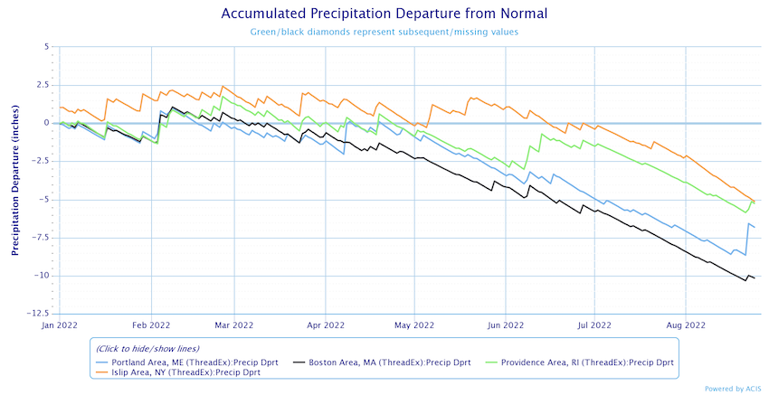
Accumulated Precipitation Departure from Normal
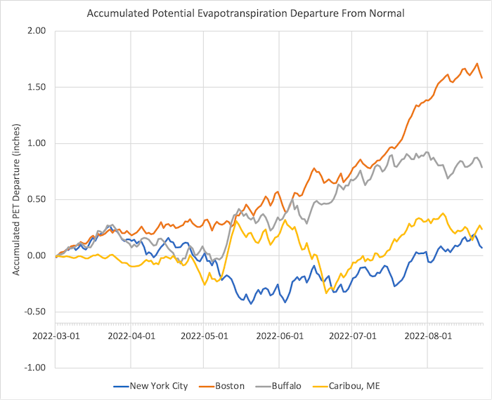
Accumulated Potential Evapotranspiration (PET) Departure from Normal
State-Reported Impacts
New England
- August 16, 2022: Boston Herald – Northeast Farmers Face Drought Challenges
- August 16, 2022: The Washington Post – Northeast Drought
Connecticut
- August 26, 2022: Governor Lamont – Primary Natural Disaster Area Designation
- August 18, 2022: Fox61 News – Not Enough Rain for Most Farms
- August 18, 2022: Governor Lamont – Drought Declaration for Eastern Counties
- August 18, 2022: Hartford Courant – Dry Weather Expected to Continue
- August 17, 2022: NBC CT – Drought Impacts on Trees
- August 16, 2022: WNPR – Agriculture Commissioner Weighs in on Drought
Maine
- August 15, 2022: Maine Public Radio – Honey Bees and Drought
- August 14, 2022: Bangor Daily News - Extreme Measures as Wells Dry Up
- August 10, 2022: Maine Public Radio – Blueberries and Drought
- August 8, 2022: Maine Public Radio – Livestock, Hay and Drought
Massachusetts
- August 26, 2022: State Drought Task Force Update - Aug. 24, 2022
- August 18, 2022: NBC10 Boston – National Guard Activated to Fight Briarwood Fire
- August 17, 2022: New England Public Media – Drought Challenges Farm Resilience
- August 16, 2022: Spectrum News1 – Eco-drought Impacts in Worcester Area
- August 14, 2022: MassLive – Heat and Drought Impacts on the Farm
- August 13, 2022: Boston25 News – Bears
- August 11, 2022: NBC10 Boston – Saving the Trees During Drought
- August 10, 2022: WCVB5 Boston – Drought Impacts on Christmas Trees
New Hampshire
- August 17, 2022: New Hampshire Bulletin/Patch – Water Restrictions in 78 Communities
New York
- August 23, 2022: WGRZ Channel 2 – First Apples of the Season are Sweeter but smaller due to Drought
- August 22, 2022: News7 – Watertown Vegetable Growers Struggling
- August 19, 2022: Patch – Severe Drought on Long Island’s South Shore
- August 18, 2022: NBC News 4 NY – Rockland County Mandatory Water Restrictions
- August 16, 2022: NYup.com – Drought Watch Area More Than Doubles
- August 15, 2022: Patch – Drought Across the Hudson Valley
- August 12, 2022: News12 New Jersey – Hudson Valley Farmers, Drought and Debt Relief
- August 8–10, 2022: DEC Forest Rangers Week in Review – Wildland Fire Reports for Putnam, Essex, Suffolk and Rockland Counties
Rhode Island
- August 24, 2022: The Providence Journal – Too Much and Too Little Rain
- August 23, 2022: WPRI.com12 – Statewide Disaster Declaration
- August 17, 2022: Public Radio 89.3 – Disaster Relief if not Rain Relief
- August 9, 2022: Governor Issues Statewide Drought Advisory
Outlooks
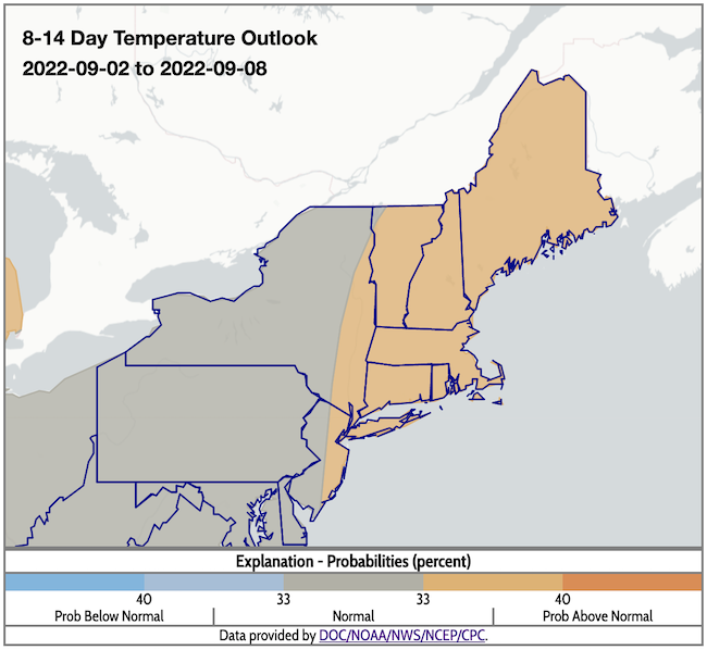
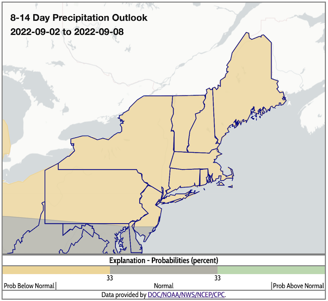
- According to the Climate Prediction Center's 8–14 day outlook (valid September 2–8, 2022), there is a greater likelihood of above-normal temperatures for most of the Northeast, except the northwestern corner of Vermont and western/central New York, where odds favor near-normal conditions. Odds favor below-normal precipitation across the entire region.
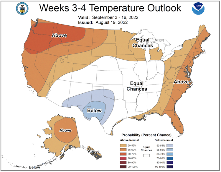
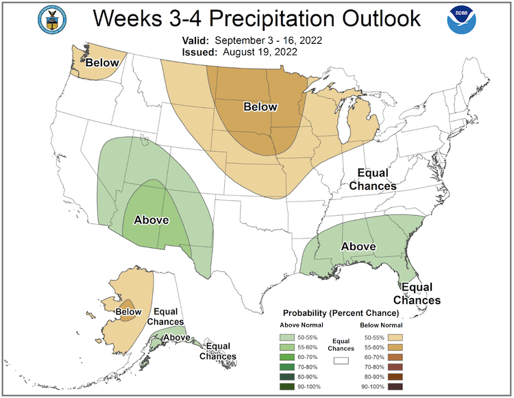
- The week 3–4 outlook (valid September 3–16, 2022) shows a greater likelihood of above-normal temperatures across the Northeast, as well as equal chances of above- or below-normal precipitation for the entire region.
8–14 Day Temperature Outlook
8–14 Day Precipitation Outlook
Temperature Outlook Week 3–4
Precipitation Outlook Week 3–4
Ecological Drought
"Short-term drought (a month or two) normally has little impact on tree morphology (including limb loss). Prolonged drought (multiple months or years) can cause trees to die back, which starts with the loss of the outermost branches. If the drought and/or other stress persists, the dieback can progress to limbs and, if severe enough, to whole tree mortality. There are lots of factors (e.g., soils, tree species, and other stresses) that determine how fast and how susceptible a tree is to drought-induced dieback."
– Steven McNulty, USDA Forest Service Northern Research Station; USDA Forest Service Eastern Threat Center (Steven.Mcnulty@usda.gov)
“The Emerald ash borer has been rapidly expanding in parts of the Northeast this year and there are many dying and newly dead ash across NH, VT, MA, and ME. There was also a spongy moth (formerly gypsy moth) outbreak earlier in the summer further confusing things. There is definitely some early leaf fall among other species (especially in the driest areas) and this is a normal response to intense drought.”
– David Hollinger, USDA Northeast Climate Hub, Director; Forest Service - Northern Research Station (david.hollinger@usda.gov)
What We Are Watching
Dryness expands and worsens in New Jersey, increasing concerns about drought impacts in and around the New York City metropolitan area.
Featured Resources
- Flash Drought Prediction and Monitoring Tools
- Flash Drought Tools: Advantages and Disadvantages by Indicator Type
- U.S. Climate Resilience Toolkit: For more on steps to resilience, browse information on topics that range from ecosystems to water resources and guidelines for including Traditional Knowledges (TK) in adaptation activities.
- USGS National Water Dashboard: Provisional real-time water data collected at USGS observation stations.
Additional Resources
- The 1965 Northeast Drought - The New England Historical Society Perspective
- Look back at previous Northeast DEWS Drought Status Updates
- Your local National Weather Service office
- NOAA Regional Climate Services Monthly Webinar Series (next webinar is on August 30)
- USDA Northeast Climate Hub
- USGS New England and New York Water Science Centers
Contacts for More Information
Sylvia Reeves
Regional Drought Information Coordinator (Northeast DEWS)
NOAA/CIRES/National Integrated Drought Information System (NIDIS)
Email: sylvia.reeves@noaa.gov
Ellen L. Mecray
Regional Climate Services Director, Eastern Region
NOAA/NESDIS/National Centers for Environmental Information
Email: Ellen.L.Mecray@noaa.gov
Prepared By
Sylvia Reeves
NOAA/National Integrated Drought Information System (NIDIS), CIRES
Samantha Borisoff, Jessica Spaccio, Keith Eggleston, Art DeGaetano
Northeast Regional Climate Center
Ellen Mecray
Regional Climate Services Director, Eastern Region, NOAA
David Hollinger
USDA Climate Hubs
Gardner Bent
USGS New England Water Science Center
In partnership with National Weather Service Offices of the Northeast and State Climate Offices of the Northeast.
This drought status update is issued in partnership between the National Oceanic and Atmospheric Administration (NOAA), U.S. Geological Survey, and the U.S. Department of Agriculture (USDA) to communicate concern for drought expansion and intensification within the Northeast U.S. based on recent conditions and the forecasts and outlooks. NIDIS and its partners will issue future drought status updates as conditions evolve.
