Warm and Dry Conditions Set the Stage for Increased Wildfire Activity, Diminished Water Supplies This Summer
Key Points
- Recent warm and dry conditions have caused snowpack to melt rapidly and earlier than normal across much of the Pacific Northwest.
- Rapid snowmelt and increased evaporative demand caused soils and vegetation to dry out very quickly, resulting in an early start to the fire season.
- Early snowmelt and recent dry, warm conditions have caused streamflows to rapidly decline, particularly west of the Cascade Range and in the Oregon Coast Range. Water supplies may be negatively impacted this summer.
- Over the past month, drought and Abnormal Dryness (D0) developed and expanded across numerous tribal lands in western Washington and Oregon, northeastern Oregon, and northwestern Idaho.
- The Washington Department of Ecology declared a Drought Emergency for portions of the Yakima Basin, which includes part of the Yakama Nation Reservation.
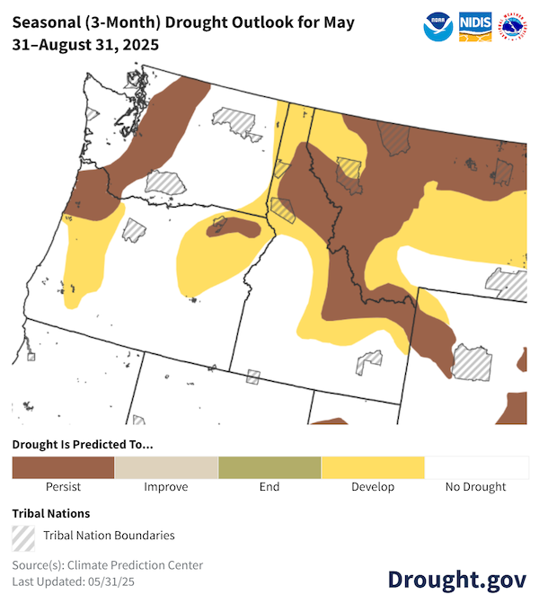
- Above-normal temperatures and below-normal precipitation are expected to cause drought to further develop and intensify this summer, and to increase wildfire potential.
This update is based on data available as of Friday, May 30, 2025 at 10 a.m. PT. We acknowledge that conditions are evolving.
Current U.S. Drought Monitor map for tribal lands in the Pacific Northwest, as of May 27, 2025. The U.S. Drought Monitor (USDM) is updated each Thursday to show the location and intensity of drought across the country using 5 classifications: Abnormally Dry (D0), showing areas that may be going into or are coming out of drought, and four levels of drought (D1–D4).
The U.S. Drought Monitor is a joint effort of the National Drought Mitigation Center, U.S. Department of Agriculture, and National Oceanic and Atmospheric Administration.
A drought index combines multiple drought indicators (e.g., precipitation, temperature, soil moisture) to depict drought conditions. For some products, like the U.S. Drought Monitor, authors combine their analysis of drought indicators with input from local observers. Other drought indices, like the Standardized Precipitation Index (SPI), use an objective calculation to describe the severity, location, timing, and/or duration of drought.
Learn MorePeriods of drought can lead to inadequate water supply, threatening the health, safety, and welfare of communities. Streamflow, groundwater, reservoir, and snowpack data are key to monitoring and forecasting water supply.
Learn MoreDrought can reduce the water availability and water quality necessary for productive farms, ranches, and grazing lands, resulting in significant negative direct and indirect economic impacts to the agricultural sector. Monitoring agricultural drought typically focuses on examining levels of precipitation, evaporative demand, soil moisture, and surface/groundwater quantity and quality.
Learn MoreU.S. Drought Monitor Categories
D0 - Abnormally Dry
Abnormally Dry (D0) indicates a region that is going into or coming out of drought. View typical impacts by state.
D1 - Moderate Drought
Moderate Drought (D1) is the first of four drought categories (D1–D4), according to the U.S. Drought Monitor. View typical impacts by state.
D2 - Severe Drought
Severe Drought (D2) is the second of four drought categories (D1–D4), according to the U.S. Drought Monitor. View typical impacts by state.
D3 - Extreme Drought
Extreme Drought (D3) is the third of four drought categories (D1–D4), according to the U.S. Drought Monitor. View typical impacts by state.
D4 - Exceptional Drought
Exceptional Drought (D4) is the most intense drought category, according to the U.S. Drought Monitor. View typical impacts by state.
Total Area in Drought (D1–D4)
Percent area of the states in the Pacific Northwest that is currently in drought (D1–D4), according to the U.S. Drought Monitor.
Current U.S. Drought Monitor map for tribal lands in the Pacific Northwest, as of May 27, 2025. The U.S. Drought Monitor (USDM) is updated each Thursday to show the location and intensity of drought across the country using 5 classifications: Abnormally Dry (D0), showing areas that may be going into or are coming out of drought, and four levels of drought (D1–D4).
The U.S. Drought Monitor is a joint effort of the National Drought Mitigation Center, U.S. Department of Agriculture, and National Oceanic and Atmospheric Administration.
The U.S. Drought Monitor is updated every Thursday morning, with data valid through 7 a.m. ET the previous Tuesday.
A drought index combines multiple drought indicators (e.g., precipitation, temperature, soil moisture) to depict drought conditions. For some products, like the U.S. Drought Monitor, authors combine their analysis of drought indicators with input from local observers. Other drought indices, like the Standardized Precipitation Index (SPI), use an objective calculation to describe the severity, location, timing, and/or duration of drought.
Learn MorePeriods of drought can lead to inadequate water supply, threatening the health, safety, and welfare of communities. Streamflow, groundwater, reservoir, and snowpack data are key to monitoring and forecasting water supply.
Learn MoreDrought can reduce the water availability and water quality necessary for productive farms, ranches, and grazing lands, resulting in significant negative direct and indirect economic impacts to the agricultural sector. Monitoring agricultural drought typically focuses on examining levels of precipitation, evaporative demand, soil moisture, and surface/groundwater quantity and quality.
Learn MoreCurrent Conditions and Impacts
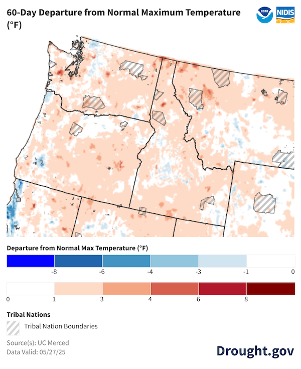
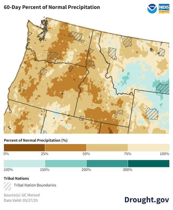
- During the past 60 days, much of the region experienced above-normal temperatures and below-normal precipitation. The exceedingly warm conditions caused the snowpack to melt rapidly. Peak snowpack was normal to above normal for the water year throughout much of Idaho, northwestern Montana, southern Washington, and eastern portions of Oregon. However, peak snowpack was below normal for many locations throughout the Cascade Range in northern and central Washington and Oregon.
- Drought conditions expanded across the region during the spring. According to the May 27 U.S. Drought Monitor, the Flathead Reservation in Montana is experiencing the most intense drought conditions on tribal lands in the region, with 13.6% of the reservation in Severe Drought (D2). Nearly two-thirds of tribal lands in the Pacific Northwest are experiencing drought or Abnormal Dryness (D0-D2).
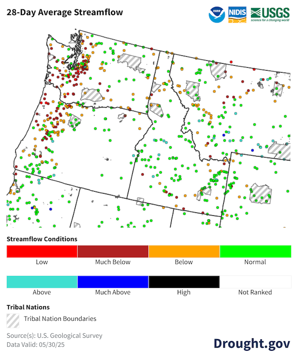
- Recent low precipitation, high temperatures, and early snowpack meltout caused streamflows to decline throughout western Washington and Oregon. Many streamgages in this region reported much-below-normal streamflow. Elsewhere in the Pacific Northwest, streamflows varied from above normal to below normal.
- On April 8, the Washington Department of Ecology declared a Drought Emergency for the Yakima Basin watersheds of Naches, Upper Yakima, and Lower Yakima, which includes part of the Yakama Nation Reservation. Drought in these watersheds in 2023 and 2024 created long-term precipitation and soil moisture deficits. Spring runoff will not be sufficient to fill reservoirs or overcome the soil moisture deficit. The declaration made funding available from the state to federally recognized tribes to alleviate the immediate effects of drought conditions.
- A Drought Advisory was issued at the same time for parts of Whatcom, Skagit, Snohomish, King, Pierce, Chelan, and Okanogan counties in Washington. An advisory is used as a readiness and communication tool to warn that drought conditions may be developing. Entities within those regions are not eligible for the grant funds associated with a Drought Emergency but are encouraged to start planning and to take voluntary conservation measures.
- The fire season has started early. According to the Confederated Salish and Kootenai Tribes Division of Fire, several fires have occurred on the Flathead Reservation in northwestern Montana this spring.
Above-Normal Temperatures Prevailed During the Past 60 Days
Extremely Low Precipitation Persisted During Spring
Streamflows Much Below Normal in Cascades Region
Outlooks and Potential Impacts for the Pacific Northwest
Outlooks
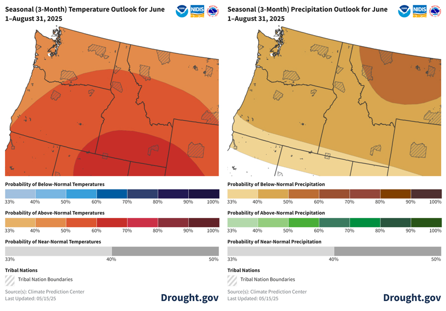
- The NOAA Climate Prediction Center’s outlooks for June–August show increased chances for above-normal temperatures and below-normal precipitation across the Pacific Northwest.
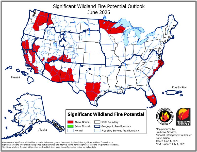
- Wildfires are expected to be a concern throughout the region this summer, with the likelihood of above-normal significant wildland fire potential increasing across the region as the summer progresses.
- As is the case in any summer, short-duration heat waves are possible, but especially this summer with above-normal temperatures predicted.
- As a result of these outlooks, drought is expected to persist or redevelop across tribal lands in Washington, Idaho, and western Montana.
Potential Impacts for Summer 2025
- According to the U.S. Bureau of Reclamation, water supply in the Yakima Basin will not fully meet irrigation demands this season. As of May 20, the Bureau of Reclamation is predicting that senior water users will receive 100% of their entitlements, but proratable water right holders (water users with May 10, 1905 water rights) will receive only 48% of their normal entitlements from May 20–September 30.
- Junior water right holders will be curtailed entirely in the Yakima Basin (juniors' priority date is after May 10, 1905).
- This region can be particularly vulnerable to extreme heat due to the lack of widespread air conditioning. This puts certain populations, such as elders and young children, at higher risk for experiencing negative health effects of heat.
- Impacts from a potentially above-normal wildfire season may include deteriorated air quality, damage to pastures and rangeland, degraded water quality, and disruptions to irrigation canals.
- Agricultural producers anticipate the need to fallow land and cease irrigation, leading to crop stress and reduced yields. This is due to inadequate water availability. Farmers with junior water rights are expected to be interrupted earlier this year due to compounding snowpack deficits and reduced streamflows.
- River flows are projected to decline to levels in which fish will not be able to migrate later this summer, resulting in stranding and increased fish mortality of critical anadromous and resident fishes. Low streamflow leads to higher stream temperatures that are dangerous for fish.
- Impacts to small and more vulnerable public water systems may arise later in summer or early fall. Small water systems may need to truck water, deepen wells, and conduct additional maintenance to support domestic water uses.
Above-Normal Temperatures and Below-Normal Precipitation Expected This Summer
Drought Anticipated to Persist and Further Develop This Summer
Above-Normal Significant Wildland Fire Potential Expected This Summer
Resources and Impact Reporting
- Water resources drought response grants are available to federally recognized tribes in the state of Washington’s Drought Emergency declaration areas. As conditions evolve, the Washington State Department of Ecology may expand the areas included in the Drought Emergency declaration. Visit Ecology’s Drought Response web page for the most current drought declaration areas, or contact Caroline Mellor, Statewide Drought Lead with the Washington State Department of Ecology, for more information.
- Follow these steps from the Washington State Department of Health to identify and avoid potential water shortages.
- Reduce your wildfire risk with these resources:
- Air quality is often degraded in areas where wildfire smoke is present, and elders and individuals with respiratory issues are at greatest risk for adverse health effects. The U.S. Environmental Protection Agency is loaning air monitoring equipment to tribal air organizations through its Wildfire Smoke Air Monitoring Response Technology (WSMART) loan program. If you represent a tribal air agency, fill out this form to request air monitors.
- Stay safe during extreme heat and learn the signs of heat-related illness by following these tips from the National Integrated Heat Health Information System (NIHHIS). Stay informed about heat advisories and excessive heat warnings issued for your area by following your local National Weather Service office.
- The U.S. Department of Agriculture Farm Service Agency (FSA) provides disaster assistance to producers across the country.
- This fact sheet describes the types of disaster designations and the process for declaring a disaster.
- This packet contains all of the FSA eligibility forms needed for Tribal Nations to apply for assistance.
- Join NIDIS, the Montana Climate Office, and the Native Resilience Project for an update on drought conditions across the Columbia and Upper Missouri River Basins and a demonstration of the Upper Missouri River Basin Drought Indicators Dashboard. This dashboard provides the ability to view drought data at the tribal reservation level across the Pacific Northwest and Northern Plains, and is used in operational drought assessment that informs the U.S. Drought Monitor. The webinar will be held June 10, 2025, 12 p.m.–1 p.m. PT. Register here.
- Would you like to report drought impacts or learn about impacts already reported? The Condition Monitoring Observer Reports on Drought (CMOR-Drought) tool allows people to submit observation reports related to drought or unusually wet conditions. The observations are presented in a map that can be used to view and access submitted reports.
Prepared By
Crystal Stiles, Jason Gerlich
Cooperative Institute for Research in Environmental Sciences (CIRES), NOAA’s National Integrated Drought Information System
Kylie Avery, Patrick Freeland
Affiliated Tribes of Northwest Indians, Northwest Climate Adaptation Science Center
Larry O’Neill
Oregon Climate Service, Oregon State University
Erica Fleishman
OCCRI, Oregon State University
Karin Bumbaco
Office of the Washington State Climatologist, University of Washington
Caroline Mellor
Washington State Department of Ecology
This Drought Status Update is issued in partnership by the National Oceanic and Atmospheric Administration (NOAA) and the Affiliated Tribes of Northwest Indians, Northwest Climate Adaptation Science Center, Oregon Climate Service, Oregon Climate Change Research Institute, Office of the Washington State Climatologist, and Washington State Department of Ecology to communicate potential areas of concern for drought expansion or development across tribal lands within the Pacific Northwest DEWS region on the basis of recent conditions and forecasts. NIDIS and its partners will issue future Drought Status Updates as conditions evolve.
