Record-Breaking Snowpack Melt Out Across the West
Key Points
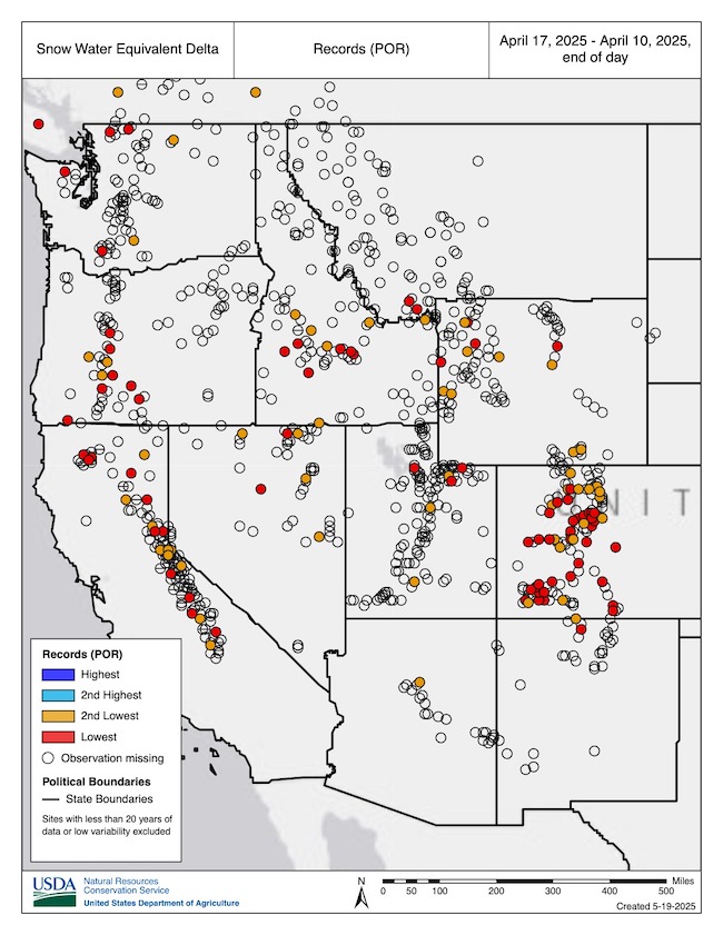
- Above-normal temperatures and below-normal precipitation continued to rapidly melt western U.S. snowpack. Nearly all western basins are now in late season snow drought, despite many stations reaching near to above-average peak snow water equivalent (SWE) during the snow accumulation season. Some stations, including some in Nevada, Colorado, Utah, and New Mexico, saw record early melt out.
- The rapid depletion of snow, coupled with increased evaporative demand (the “thirst” of the atmosphere), can rapidly dry soils and vegetation, which can lead to an early start to the fire season.
- Snowmelt this time of year is common, but such rapid melt rates are not normal. In some instances, above-normal temperatures such as these can cause snow to sublimate (transition from a solid to a gas) and reduce runoff into streams and reservoirs.
- Tracking snow drought during the snowmelt season is important, because the rate and disappearance of snow can cause flooding and impact water supply, soil moisture, ecosystems, recreation, and wildfire potential.
- Water supply forecasts for the Colorado River Basin, Rio Grande Basin, and Columbia River Basin declined compared to April 1 forecasts due to well-below-average April precipitation.
- The NOAA Climate Prediction Center’s 6-10 day outlook favors above-normal temperatures across most of the West, which could again accelerate snowmelt rates at higher elevations where snow remains.
Snow Telemetry (SNOTEL) snow water equivalent (SWE) values for watersheds in the western U.S. as a percentage of the 1991–2020 median. Only stations with at least 20 years of data are included in the station medians. This map is valid as of May 13, 2025.
For an interactive version of this map, please visit NRCS.
Drought is defined as the lack of precipitation over an extended period of time, usually for a season or more, that results in a water shortage. Changes in precipitation can substantially disrupt crops and livestock, influence the frequency and intensity of severe weather events, and affect the quality and quantity of water available for municipal and industrial use.
Learn MoreSnow drought is a period of abnormally low snowpack for the time of year. Snowpack typically acts as a natural reservoir, providing water throughout the drier summer months. Lack of snowpack storage, or a shift in timing of snowmelt, can be a challenge for drought planning.
Learn MorePeriods of drought can lead to inadequate water supply, threatening the health, safety, and welfare of communities. Streamflow, groundwater, reservoir, and snowpack data are key to monitoring and forecasting water supply.
Learn MoreIn a drought, lower water levels or snowpack can affect the availability of recreational activities and associated tourism, and a resulting loss of revenue can severely impact supply chains and the economy. Drought—as well as negative perceptions of drought, fire bans, or wildfires—may also result in decreased visitations, cancellations in hotel stays, a reduction in booked holidays, or reduced merchandise sales.
Learn MorePercent of Median Snow Water Equivalent
< 50% of Median
Current snow water equivalent (SWE) is less than 50% of the median SWE value for this day of the year, compared to historical conditions from 1991–2020.
50%–70% of Median
Current snow water equivalent (SWE) is between 50%–70% of the median SWE value for this day of the year, compared to historical conditions from 1991–2020.
70%–90% of Median
Current snow water equivalent (SWE) is between 70%–90% of the median SWE value for this day of the year, compared to historical conditions from 1991–2020.
90%–110% of Median
Current snow water equivalent (SWE) is between 90%–110% of the median SWE value for this day of the year, compared to historical conditions from 1991–2020.
110%–130% of Median
Current snow water equivalent (SWE) is between 110%–130% of the median SWE value for this day of the year, compared to historical conditions from 1991–2020.
130%–150% of Median
Current snow water equivalent (SWE) is between 130%–150% of the median SWE value for this day of the year, compared to historical conditions from 1991–2020.
>150% of Median
Current snow water equivalent (SWE) is greater than 150% of the median SWE value for this day of the year, compared to historical conditions from 1991–2020.
Snow Telemetry (SNOTEL) snow water equivalent (SWE) values for watersheds in the western U.S. as a percentage of the 1991–2020 median. Only stations with at least 20 years of data are included in the station medians. This map is valid as of May 13, 2025.
For an interactive version of this map, please visit NRCS.
View an updated, interactive version of this map from the USDA's Natural Resources Conservation Service. You can also view SWE data on Drought.gov.
Drought is defined as the lack of precipitation over an extended period of time, usually for a season or more, that results in a water shortage. Changes in precipitation can substantially disrupt crops and livestock, influence the frequency and intensity of severe weather events, and affect the quality and quantity of water available for municipal and industrial use.
Learn MoreSnow drought is a period of abnormally low snowpack for the time of year. Snowpack typically acts as a natural reservoir, providing water throughout the drier summer months. Lack of snowpack storage, or a shift in timing of snowmelt, can be a challenge for drought planning.
Learn MorePeriods of drought can lead to inadequate water supply, threatening the health, safety, and welfare of communities. Streamflow, groundwater, reservoir, and snowpack data are key to monitoring and forecasting water supply.
Learn MoreIn a drought, lower water levels or snowpack can affect the availability of recreational activities and associated tourism, and a resulting loss of revenue can severely impact supply chains and the economy. Drought—as well as negative perceptions of drought, fire bans, or wildfires—may also result in decreased visitations, cancellations in hotel stays, a reduction in booked holidays, or reduced merchandise sales.
Learn MoreSnow Drought Conditions Summary
This update is based on data available as of Thursday, May 15, 2025 at 12:00 a.m. PT. We acknowledge that conditions are evolving.
Current Conditions
Tracking snow drought during the snowmelt season is important because the rate and disappearance of snow can cause flooding and impact water supply, soil moisture, ecosystems, recreation, and wildfire potential.
Across many basins in the West, late season snow drought (snow water equivalent in the bottom 20% of historical conditions) developed amid above-normal temperatures and a very dry April and early May. Several significant melt out events impacted nearly every major mountain range. Some stations, including some in Nevada, Colorado, Utah, and New Mexico, saw record early melt out. Snowmelt this time of year is common, but such rapid melt rates are not normal. In some instances, above-normal temperatures such as these can cause snow to sublimate (transition from a solid to a gas) and reduce runoff into streams and reservoirs.
Median snowpack values are lower in late spring. As a result, even small precipitation events can cause large changes in percent of median values at this time of year without significantly increasing overall seasonal snowpack totals.
Columbia River Basin
In the Columbia River Basin, May-to-date precipitation has been below 50% of normal across large portions of the state. The Yakima River Basin and some other basins already had long-term precipitation deficits, and multiple years of drought prompted Washington to declare a drought emergency.
Earlier-than-normal snowmelt could deplete reservoir systems earlier in the season than is typical across Idaho. These lower reservoirs could lead to minimal water in storage for next year's demands. Low reservoir levels could deepen Idaho’s reliance on ample snow next winter to meet water supply. The Middle Snake River Basin saw snow water equivalent (SWE) drop from the 70th percentile to the 30th percentile in a two-week period beginning late April.
Colorado River and Rio Grande Basins
The Colorado River Basin and other portions of the central Rockies in Colorado and Utah that had above-median snowpack at the beginning of April rapidly melted later that month. Snow water equivalent (SWE) in the Colorado Headwaters Hydrologic Unit Code (HUC) 6 Basin dropped from the 30th percentile to the 10th percentile in a 7-day period in mid-April. On April 24, Utah declared a drought emergency in 17 southern Utah counties in response to low streamflow forecasts, increased water demand as temperatures rise, and drought.
As of May 4, parts of Wolf Creek Pass were snow-free, meaning they melted nearly 3-4 weeks early. The SNOTEL station at Wolf Creek Pass entered near-record low SWE totals for this time of year. The Baldy Mountain SNOTEL site in Arizona (9,210-foot elevation) remained mostly snow-free throughout the winter.
Looking Ahead
Low Water Supply Forecast
Water supply forecasts for the Colorado River Basin, Rio Grande Basin, and Columbia River Basin declined compared to April 1 forecasts due to well-below average April precipitation. The northern Rockies in the headwaters of the Missouri River Basin also experienced rapid melt out and early peak snow water equivalent (SWE). With 50% of the Missouri River Basin in drought, persistent dry conditions coupled with early peak SWE have reduced water supply forecasts.
Warm Temperatures, Near-Normal Precipitation Support Early Snowmelt
The NOAA Climate Prediction Center’s June outlook favors above-normal temperatures and below-normal precipitation across most of the West. California, Nevada, Arizona, and southwest Utah have equal chances of above-, below-, or near-normal precipitation. Conditions are favorable for earlier-than-normal snow meltout. Melt out is common this time of year. However, the rapid depletion of snow at higher elevations, coupled with increased evaporative demand, can rapidly dry soils and vegetation. This can lead to an early start to the fire season.
Drought Likely to Persist
The seasonal drought outlook from the Climate Prediction Center favors drought development or expansion across the northern Rockies of Idaho and Montana, which includes some areas that received above-average snowpack earlier in the season but melted rapidly. The southern Rockies saw low snowpack throughout most of the season, and drought is expected to persist across these areas, including southern California, Nevada, Utah, and Colorado, along with Arizona, New Mexico, and a portion of Washington.
Heightened Fire Risk for Parts of the West
Late season snow drought from rapid snowmelt and early melt out, above-normal temperatures, and below-normal precipitation led to significant wildland fire potential. In Arizona and New Mexico, record low snowpack this winter and substantial long-term deficits favor above-normal wildland fire potential in May.
National Interagency Fire Center outlooks for June favor above-normal wildland fire potential in areas with significant snow drought, including Arizona and New Mexico. Increased fire potential extends into the southern portions of Nevada, Utah, and Colorado. June outlooks also favor above-normal fire potential in eastern Washington, northern Idaho, and the Sierra Nevada of California.
In July and August, significant wildland fire potential is favored across nearly all of Washington, Oregon, Montana, and Idaho. Significant portions of California, northern Nevada, and northeast Wyoming are also predicted to have increased fire potential.
Late Season Snow Drought Developed Across the West

Spring Heat Wave Rapidly Melts Snow
Rapid Snowmelt Led to Rapid SWE Losses in the Colorado Headwaters Basin

Rapid Snowmelt Led to Rapid SWE Losses in the Middle Snake-Boise Basin

* Quantifying snow drought values is an ongoing research effort. Here we have used the 20th percentile as a starting point based on partner expertise and research. Get more information on the current definition of snow drought. Note that reporting of SWE by Snow Telemetry (SNOTEL) stations may be unavailable or delayed due to technical, weather or other issues, which may affect snow drought depiction in this update.
For More Information, Please Contact:
Daniel McEvoy
Western Regional Climate Center
Daniel.McEvoy@dri.edu
Jason Gerlich
CIRES/NOAA/NIDIS Pacific Northwest and Missouri River Basin Regional Drought Information Coordinator
Jason.Gerlich@noaa.gov
Amanda Sheffield
CIRES/NOAA/NIDIS California-Nevada Regional Drought Information Coordinator
Amanda.Sheffield@noaa.gov
NIDIS and its partners launched this snow drought effort in 2018 to provide data, maps, and tools for monitoring snow drought and its impacts as well as communicating the status of snow drought across the United States, including Alaska. Thank you to our partners for your continued support of this effort and review of these updates. If you would like to report snow drought impacts, please use the link below. Information collected will be shared with the states affected to help us better understand the short term, long term, and cumulative impacts of snow drought to the citizens and the economy of the regions reliant on snowpack.
Report Your Snow Drought Impacts
Data and Maps | Snow Drought
Research and Learn | Snow Drought

