
Strong El Niño Tilts Odds Toward a Wetter Winter Across the Southeast
El Niño is strengthening in the tropical Pacific and is expected to tilt the odds toward a wetter winter across the Southeast, according to NOAA’s Climate Prediction Center (CPC).
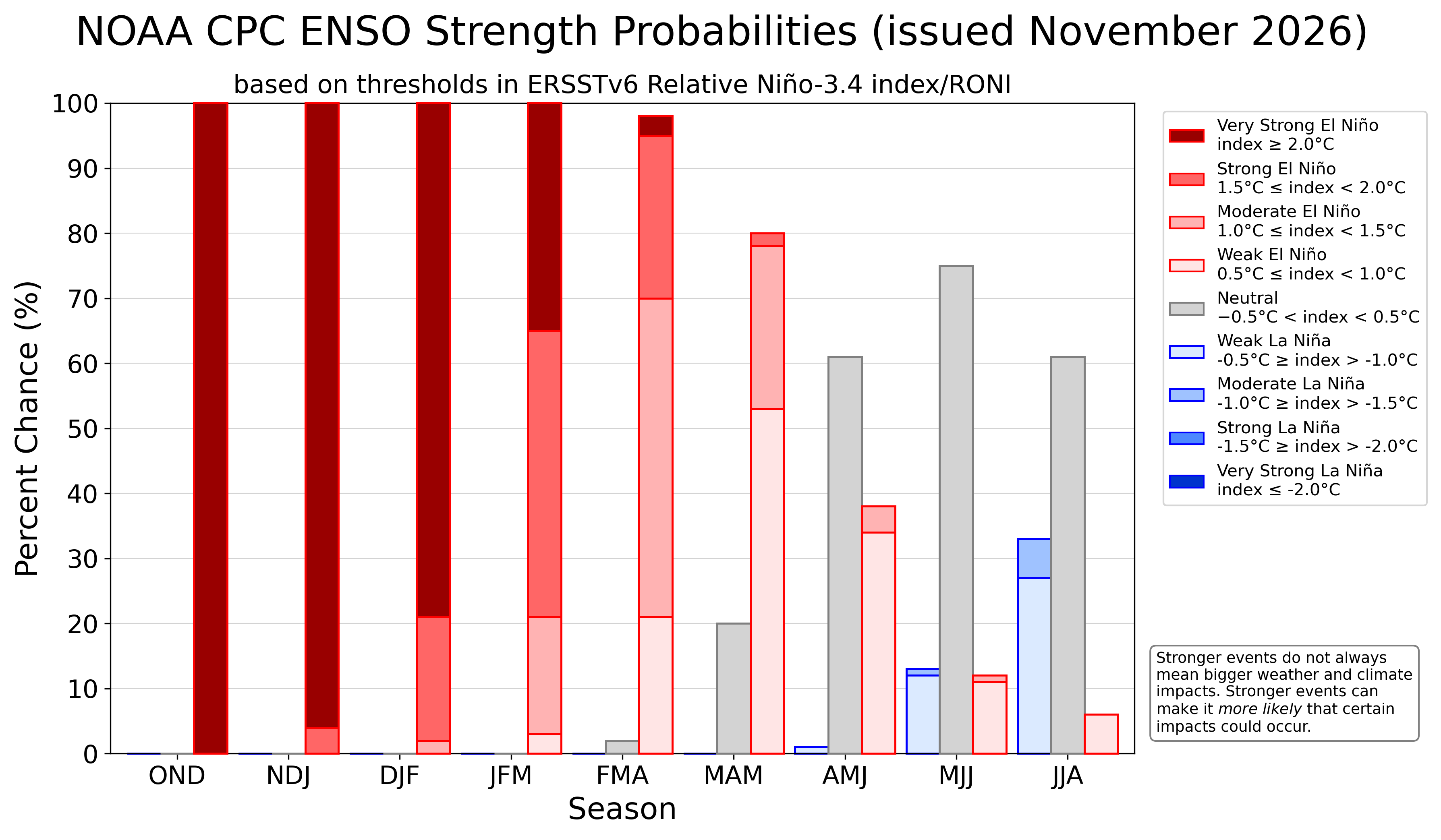
Forecasters estimate a roughly 80% chance that strong to very strong El Niño conditions will persist through January–March 2027, potentially bringing welcome relief to drought-stressed farms and watersheds while increasing the risk of river flooding.
Michelle L’Heureux, lead of NOAA’s El Niño–Southern Oscillation (ENSO) forecast team, detailed the outlook during the November 17, 2026 Southeast Climate Monthly Webinar, hosted by NOAA’s National Integrated Drought Information System (NIDIS), the Southeast Regional Climate Center (SERCC), and NOAA’s National Weather Service (NWS). An El Niño Advisory has been in effect since June 2026, and while tropical Pacific ocean temperatures are expected to peak in late fall or early winter, L’Heureux noted that weather impacts across the Southern United States typically amplify later in the winter and early spring.
Tracking a Historically Strong El Niño
To measure the strength of the current event, NOAA scientists use the Relative Oceanic Niño Index (RONI), which filters out long-term tropical ocean warming to isolate east-west sea surface temperature differences across the equatorial Pacific. Those temperature gradients drive coupled interactions between the ocean and atmosphere that shift global weather patterns.
According to L’Heureux, the 2026–2027 El Niño is tracking closely with the historic 1997–1998 event. RONI values are hovering near 2.0°C above average and a 60% probability of reaching or exceeding 2.5°C—a threshold that would rival or surpass the 1982–1983 record of 2.4°C. The pair of subsurface ocean heat observations and strongly shifted tropical rainfall patterns confirm the El Niño is present.
What Shifting Odds Mean for Southeast Drought and Flooding
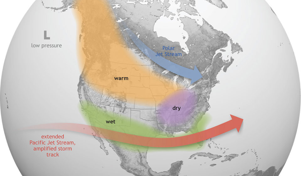
L’Heureux emphasized that El Niño is a large-scale climate pattern rather than a single storm, meaning it alters seasonal probabilities rather than guaranteeing specific weather outcomes. Across the United States, the Southeast exhibits one of the strongest historical El Niño precipitation signals, with CPC winter outlooks (December 2026–February 2027) favoring above-average rainfall and occasional snowfall across the region.
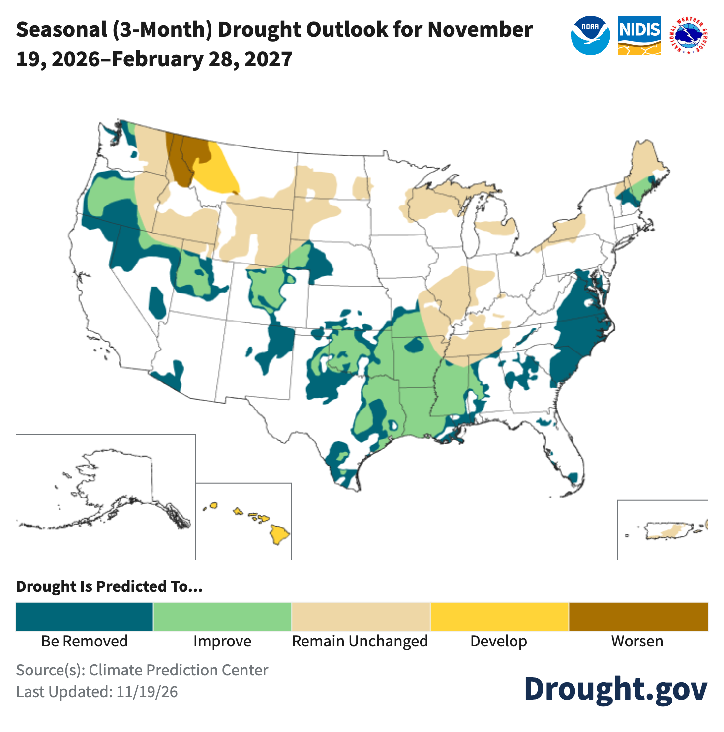
For much of the Southeast, wetter winter conditions could ease persistent dryness. Presenters reported that roughly two-thirds of the Southeast Drought Early Warning System (DEWS) region remains Abnormally Dry (D0) or in drought, according to the U.S. Drought Monitor. Dry soils and low streamflows have delayed winter forage growth and prompted early cattle sales in parts of the region.
Much of the Southeast region has a 50% chance or greater for above-normal precipitation during winter. These areas have a higher likelihood for flooding, particularly in areas where soils are already saturated. An active storm track with heavy rainfall is shifting into northern Florida, Georgia, and Alabama.
Advancing Early Warning and Regional Preparedness
Because El Niño develops months before its peak impacts reach North America, seasonal forecasts give communities valuable lead time to prepare. Water managers, agricultural producers, and emergency planners should use the outlook to balance preparations for both drought recovery and potential river flooding. L’Heureux summarized NOAA’s guidance simply: “Don’t panic—prepare.”
To view the full webinar recording, visit the NIDIS YouTube channel. Updated monthly and seasonal climate outlooks are available through NOAA’s Climate Prediction Center.