To provide the latest information on drought conditions across the West, NIDIS is joining with our federal, state, tribal, and local partners to host a drought webinar specifically for western communities. The webinar will include an update on the current drought situation and outlook, an overview of wildland fire conditions and outlook, and will feature perspectives from those on the ground who are responding to worsening drought conditions. Key discussions will include a summary of past and current conditions in terms of many climate variables like snowpack, temperatures, precipitation, soil moisture, etc.; as well as potential and ongoing impacts from drought across sectors (e.g., agriculture, water resources, recreation, etc.).
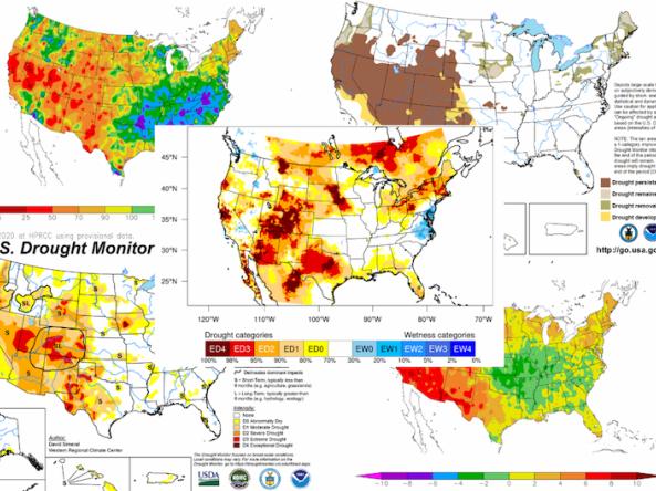
According to the April 20, 2021 U.S. Drought Monitor, 56.6% of the Pacific Northwest Drought Early Warning System (DEWS) is in Moderate Drought (D1). Additionally, a pocket of Exceptional Drought (D4) was added to Oregon, the first time that state has had D4 since 2015. Snow conditions this winter have been good in Washington and northern Oregon, and average to below average throughout the rest of the Pacific Northwest. What's the outlook for the rest of spring into summer?
Nearly 50% of the Southwestern United States is currently experiencing the most severe drought classification (D4) conditions. The most recent U.S. Drought Monitor indicated that all of the Southwest was experiencing drought, and drought is expected to continue throughout the winter and into spring. This webinar will provide an update of current drought conditions and forecasts for Arizona, Colorado, New Mexico, Utah, and Nevada, followed by a demonstration of the new Drought.gov website.

These webinars provide the region's stakeholders and interested parties with timely information on current and developing climate conditions, such as drought, floods, and tropical storms, as well as climatic events like El Niño and La Niña. Speakers may also discuss the impacts of these conditions on topics such as wildfires, agriculture production, disruption to water supply, and ecosystems. The February 9 webinar also featured a presentation on 2020 in review.