U.S. flag

An official website of the United States government

Event Date
July 21, 2022
2:00 pm - 3:45 pm
Location
Virtual

NOAA’s National Integrated Drought Information System (NIDIS) and National Integrated Heat Health Information System (NIHHIS) co-hosted two webinars in collaboration with their federal, tribal, state, and local partners, focused on drought and heat in the West and the Southern Plains. The second webinar, held from 2 p.m. to 3:45 p.m. CT on July 21, focused on the Southern Plains (Kansas, New Mexico, Oklahoma, and Texas).

Event Date
July 21, 2022
10:00 am - 12:00 pm
Location
Virtual

NOAA’s National Integrated Drought Information System (NIDIS) and National Integrated Heat Health Information System (NIHHIS) co-hosted two webinars in collaboration with their federal, tribal, state, and local partners, focused on drought and heat in the West and the Southern Plains. The first webinar, held from 10 a.m. to 12 p.m. MT on July 21, focused on the Western U.S. (Southwest, California, Pacific Northwest, Missouri River Basin, and Alaska).

The Navajo Nation Drought Severity Evaluation Tool (DSET) is a co-developed cloud-based web application designed to meet the needs of water resource managers from the Navajo Nation, improving drought reporting and management.

The Southern Regional Climate Center Dashboard provides climate data products for the Southern U.S., including Arkansas, Louisiana, Mississippi, Oklahoma, Tennessee, and Texas.

The ACF River Basin Drought and Water Dashboard is a web-based application that allows decision makers to view real-time information on the ACF River Basin all in one place. 

Published on

The Apalachicola, Chattahoochee, and Flint (ACF) Rivers, along with the Apalachicola Bay, link the people and natural systems of Alabama, Florida, and Georgia. In response to a request by regional stakeholders, and in close partnerships with state and regional partners, NOAA’s National Integrated Drought Information System (NIDIS) has launched the new ACF River Basin Drought and Water Dashboard and ACF Drought Story Map.

The NCEI Past Weather Tool allows users to search for historical temperature, precipitation, snowfall, and snow depth data for individual weather stations across the United States, as well as many international locations. Stations are part of the GHCN (Global Historical Climatology Network)-Daily dataset. 

Published on

Since early 2020, the Southwest United States has suffered record low precipitation and near-record high temperatures, gripping the region with an unyielding, unprecedented, and costly drought. This exceptional drought—marked by massive water shortages, destructive wildfires, emergency declarations, and the first ever water delivery shortfall among the states sharing the Colorado River—punctuates a two-decade warm and dry period that has baked the Southwest. A newly released report from the NOAA Drought Task Force, which is a collaboration between the NOAA Climate Program Office, National Integrated Drought Information System (NIDIS), and leading scientists, addressed four critical questions about the 2020–2021 Southwestern U.S. drought.

Event Date
September 14, 2021
1:00 pm - 2:30 pm
Location
Virtual

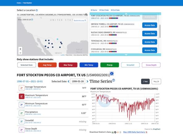
NOAA's National Integrated Drought Information System (NIDIS), the Desert Research Institute (DRI), and the Cooperative Institute for Research in Environmental Sciences at the University of Colorado Boulder (CIRES), in cooperation with the Northeast Region Climate Center (NRCC), are pleased to announce two upcoming webinars in September. In this webinar, the team will share their Drought Monitoring Toolbox for the Northeast.

Published on

The National Integrated Drought Information System is pleased to announce two new interactive features on Drought.gov: new customization and sharing options for all maps as well as new interactive economic sector maps. These new communication tools will help decision makers and the public respond to the current drought, prepare for future drought conditions, and improve the nation’s long-term drought resilience. These tools were launched in collaboration with NOAA’s National Centers for Environmental Information.

Subscribe to Temperature