As Drought Continues Across the Central Plains, Outlooks are Calling for Hot and Dry August
Key Points
- Drought is currently affecting 41% of the Missouri River Basin, which is 37% less than three months ago. Drought improvement has been focused in portions of the Upper Basin, which was facing intense drought at this time last year.
- In early 2022, drought started to expand and intensify in the Central Plains. This summer, extreme daytime heat along with below-normal rainfall has caused the drought to persist, and in some areas, worsen. Areas where drought has worsened this summer include southeast Wyoming, northeast Colorado, western Kansas, central/western Nebraska, southern Missouri, and northwest Iowa.
- Currently, the most significant drought impacts include very poor condition of sorghum, which is typically a drought resilient crop. Corn is also showing stress in the Central Plains and Missouri. Pasture conditions are very poor across areas in drought, providing almost no feed for livestock. Some producers in Kansas and Missouri are downsizing or selling cattle herds.
- Despite the potential for some rainfall and cooler temperatures this last week of July, forecasts are showing that August will start very hot and dry across the Missouri River Basin.
- The rest of August is likely to have above-normal temperatures and below-normal precipitation as well. This forecast means above-normal wildland fire potential in portions of the Basin, and the chances for increased drought and further deterioration of crops and rangeland.
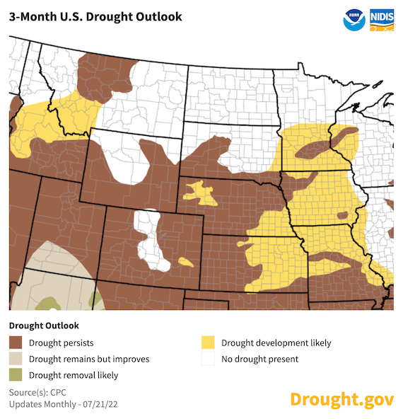
- The seasonal drought outlook (ending October 31, 2022) shows the likelihood for drought persistence and potential expansion across much of the Lower Basin (e.g., eastern Kansas, eastern Nebraska, northern Missouri, and Iowa).
Current U.S. Drought Monitor map for the Missouri River Basin Drought Early Warning System (DEWS) region with data valid for July 19, 2022. The U.S. Drought Monitor (USDM) is updated each Thursday to show the location and intensity of drought across the country. Drought categories show experts’ assessments of conditions related to dryness and drought including observations of how much water is available in streams, lakes, and soils compared to usual for the same time of year.
U.S. Drought Monitor Categories
Current U.S. Drought Monitor map for the Missouri River Basin Drought Early Warning System (DEWS) region with data valid for July 19, 2022. The U.S. Drought Monitor (USDM) is updated each Thursday to show the location and intensity of drought across the country. Drought categories show experts’ assessments of conditions related to dryness and drought including observations of how much water is available in streams, lakes, and soils compared to usual for the same time of year.
Current Conditions
- Drought is currently affecting 41% of the Missouri River Basin, which is 37% less than three months ago. The highest level of drought—exceptional drought or D4—is affecting the headwaters in Montana and southwestern Kansas. Areas within the Basin under extreme drought (D3) include western Kansas, western and northeastern Nebraska, northeast Colorado, southeast Wyoming, northern Montana, and northwestern Iowa.
- Over the last year, the drought in the Missouri River Basin has drastically shifted from the upper portions of the Basin to the central and lower portions of the Basin (Figure 1). Eastern and central Montana, North Dakota, South Dakota, and northern Wyoming have seen significant improvement in drought conditions, and many areas are now drought free.
- However, drought started to expand into the Central Plains at the start of 2022. Conditions worsened throughout the spring and have mostly persisted ever since.
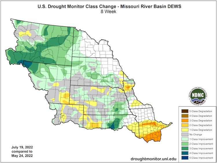
- This summer, extreme daytime heat (Figure 2) along with below-normal rainfall (Figure 3) have caused drought to persist, and in some areas, worsen. Areas with the most significant worsening over the last 8 weeks include southeastern Wyoming, northeastern Colorado, western Kansas, central/western Nebraska, southern Missouri, and northwestern Iowa (Figure 4).
Figure 1. 52-Week U.S. Drought Monitor Change Map (Since July 20, 2021)
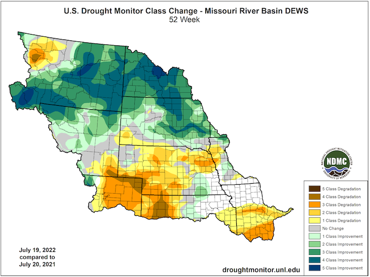
Figure 2. 60-Day Departure from Normal Maximum Temperature (°F) (May 27–July 25, 2022)
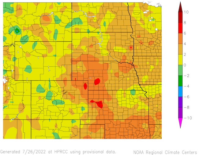
Figure 3. 60-Day Percent of Normal Precipitation (May 27–July 25, 2022)
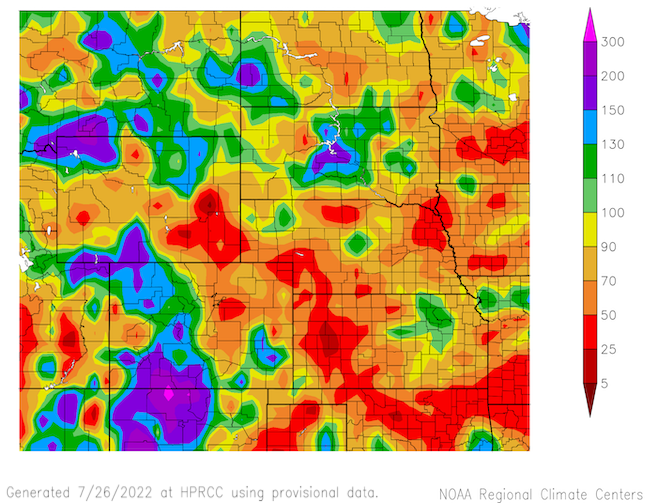
Figure 4. 8-Week U.S. Drought Monitor Change Map (Since May 24, 2022)
Impacts
- The above-normal temperatures over the last few months have resulted in increased evaporative demand, which is shown through high Evaporative Demand Drought Index (EDDI) values, particularly across Nebraska and Kansas (Figure 5). When water in the soils is limited and/or temperatures are too high, crops become stressed, leading to yield loss or crop failure in extreme cases.
- The high rates of evaporative demand and below-normal rainfall have resulted in soil moisture that is below normal across much of the Central Plains (Figure 6).
- Drought stress is showing up in crops across the Basin. In particular, the sorghum crop —typically a drought resilient crop—is very stressed, leading to an increase in the percent of sorghum reported in poor to very poor conditions over the past week (Figure 7).
- The hot and dry conditions have allowed for rapid harvest of winter wheat in Colorado. Winter wheat yields are low due to the drought, but the overall quality of the crop is better than anticipated. Despite the weather conditions, a majority of corn is reported to be in good to excellent condition across the Basin. However, that is not the case everywhere. Some producers are selling corn for silage in some of the hardest hit areas of Missouri and Kansas.
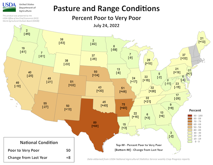
- Pasture conditions are very poor across Colorado, Kansas, Missouri, Nebraska, and Wyoming, providing almost no feed for livestock (Figure 8). Supplemental feeding is required in order to maintain livestock condition. Surface water for livestock is also becoming much more limited. Some producers in Kansas and Missouri are downsizing or selling cattle herds.
- The governors of Kansas and Missouri have issued executive orders in their states on June 27 and July 21, respectively, to accelerate drought response actions. In Kansas, all 105 counties are either in watch, warning, or emergency status, and 53 counties in southern and central Missouri are on drought alert.
- Reservoir levels on the mainstem of the Missouri River remain below normal. With the ongoing drought conditions, the U.S. Army Corps of Engineers are implementing water conservation measures, likely throughout the remainder of 2022 and into 2023. The winter release rate from Gavins Point, which is based on the September 1 storage check, will likely be at the minimum release rate of 12,000 cfs.
- Wildland fire risk has increased due to the hot and dry conditions in western Kansas, Missouri, and Nebraska, where many local areas have had to implement burn bans. In Missouri, small fires have been breaking out in Mark Twain National Forest.
- While there are no widespread concerns about municipal water supply, some cities in western Iowa (including Sioux City, IA) and Kansas (including Goodland, KS) are implementing water conservation measures.
Report your drought impacts through the Condition Monitoring Observer Reports (CMOR):
Figure 5. Evaporative Demand Drought Index (EDDI)
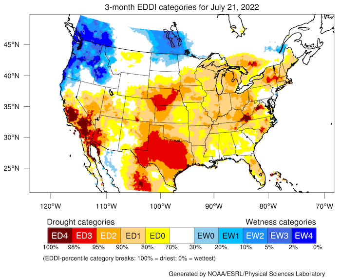
Figure 6. NASA SPoRT-LIS 0100 cm Soil Moisture Percentiles (Valid July 26, 2022)
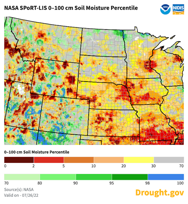
Figure 7. Sorghum Conditions (Percent Poor to Very Poor) – As of July 24, 2022
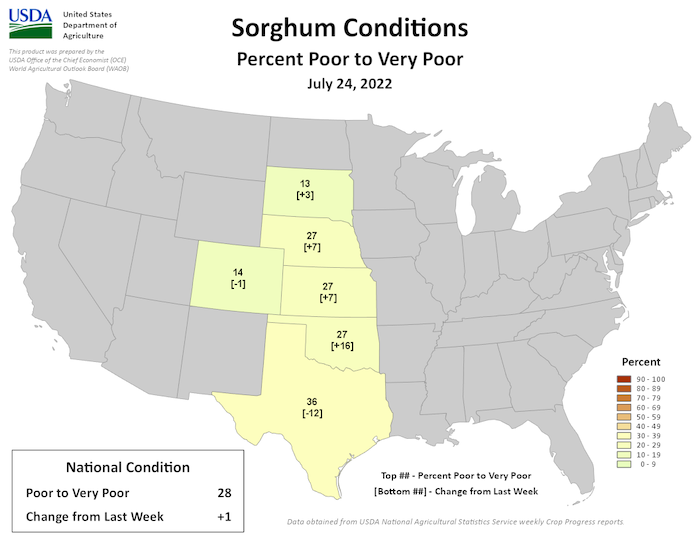
Figure 8. Pasture and Range Conditions (Rated Poor to Very Poor) – As of July 24, 2022
Outlook and Potential Impacts
- This last week in July will likely bring some relief in terms of cooler daytime temperatures and the possibility for rainfall. The precipitation totals for the next 7 days (July 26–August 2) show the possibility for a few inches rainfall across western Kansas and southern Missouri, although the scattered nature of rainfall means that it is likely not all areas will see this much rain, and drought relief could be very localized.
- Despite the potential for some short-term relief, hot and dry conditions likely will return to the region in early August (Figure 9). The overall outlook for August is leaning towards above-normal temperatures and below-normal precipitation for a majority of the Basin as well (Figure 10).
- The Significant Wildland Fire Potential Outlook for August 2022 is showing chances for above-normal fire potential across portions of Montana, eastern Wyoming, northeastern Colorado, and the western Dakotas (Figure 11). A similar pattern is shown in the September 2022 outlook as well.
- Looking at the August through October time frame, seasonal outlooks are showing a greater chance for above-normal temperatures and below-normal precipitation, which is likely to cause drought to persist in areas already experiencing drought, and drought expansion across the Lower Basin, primarily across eastern Kansas, eastern Nebraska, northern Missouri, and Iowa (Figure 12).
- Potential impacts of drought persistence through late summer and early fall could include continued crop yield loss in non-irrigated areas, increased wildfire risk, amplified hydrological impacts (e.g., streamflow, groundwater), and ecological impacts (e.g., wildlife, fish) with reduced availability of surface water.
Figure 9. Precipitation Outlook for August 3–9, 2022
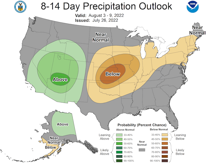
Figure 10. Monthly Precipitation Outlook for August 2022
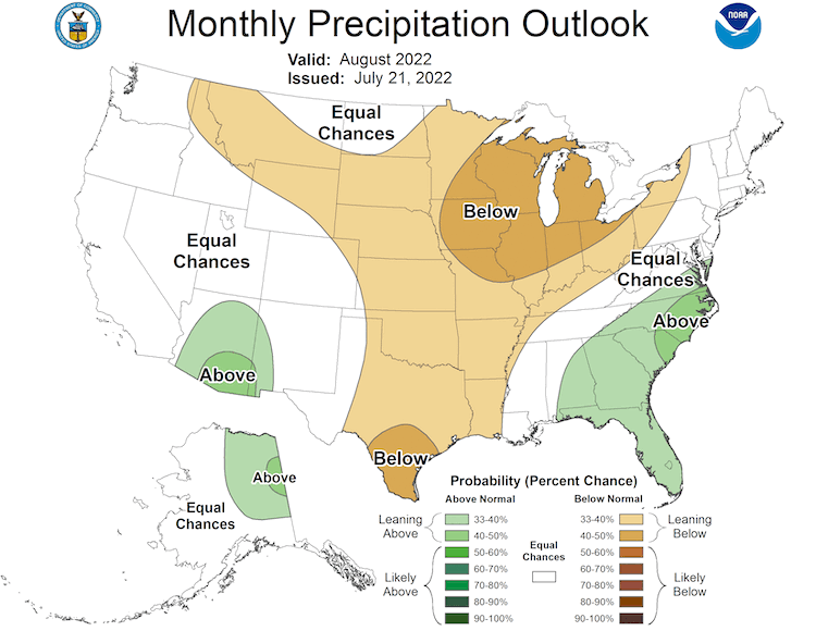
Figure 11. Significant Wildland Fire Potential Outlook for August 2022
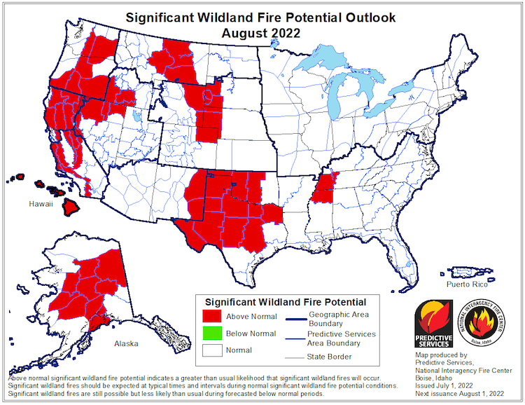
Figure 12. U.S. Seasonal Drought Outlook for July 21–October 31, 2022
For More Information
- NIDIS and its partners will issue future updates as conditions evolve.
- A special thank you to the state climate offices in the Missouri River Basin for providing local information on drought conditions and impacts included in the webinar and on this report.
- More local information is available from the following resources:
- To report or view local drought impact information:
- Report your drought impacts through Condition Monitoring Observer Reports (CMOR).
- To view or submit reports in Montana, visit the Montana Drought Impact Reporter.
- View CoCoRaHS Condition Monitoring reports.
- The upcoming North Central U.S. Climate and Drought Summary & Outlook Webinar on August 18, 2022 will offer updated information about conditions, impacts, and outlooks.
Prepared By
Molly Woloszyn
NOAA/National Integrated Drought Information System (NIDIS), CIRES/CU Boulder
Doug Kluck
NOAA/National Centers for Environmental Information
Dannele Peck & Dennis Todey
USDA Northern Plains Climate Hub & Midwest Climate Hub
Kevin Low
NOAA/National Weather Service Missouri Basin River Forecast Center
Audra Bruschi & Ray Wolf
NOAA/National Weather Service Central Region
Rezaul Mahmood & Gannon Rush
High Plains Regional Climate Center
This drought status update is issued in partnership between the National Oceanic and Atmospheric Administration (NOAA) and the U.S. Department of Agriculture (USDA) to communicate a potential area of concern for drought expansion and/or development within the Missouri River Basin based on recent conditions and the upcoming forecast. NIDIS and its partners will issue future drought status updates as conditions evolve.


