Drought Persists Across Portions of the Midwest and Missouri River Basin.
This drought status update is based on information presented on the July 1st Special North Central Webinar (watch the recording here). The PDF of the presentation is available on the High Plains Regional Climate Center website.
Key Points
- Significant rainfall over the last week brought some drought relief to portions of the central U.S. (Michigan, Wisconsin, northern Illinois, southern Iowa). However, many drought areas were missed (North Dakota, South Dakota, Minnesota, Montana, Wyoming, northern Iowa). Drought remains across much of the northern part of the Central U.S. Exceptional drought (D4)—the worst level of drought—is present in North Dakota and western Colorado, covering 18% and 17.5% of the states, respectively.
- Crop conditions are worsening over the northwestern portions of the Corn Belt. Around a quarter of the corn is in poor to very poor condition in the Dakotas, and a third of the soybean crop is in poor to very poor condition as well. More significantly, spring wheat and barley conditions are the worst at this time of year for any year since 2000.
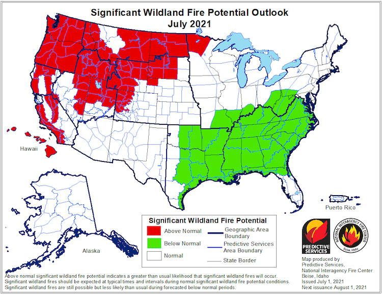
- The unseasonably warm and dry pattern is expected to continue throughout July and the rest of summer in the Upper Missouri River Basin, and as a result, drought conditions will likely persist and possibly worsen in some areas. The Significant Wildland Fire Potential Outlook for July and August shows above-normal potential for wildland fires across Montana, Wyoming, North Dakota, South Dakota, and Minnesota.
- Corn crops will be reaching the tasseling stage within the next few weeks; drought and heat stress during tasseling can have a big impact on yield. Therefore, there is a significant amount of concern if the dry forecast comes to fruition.
Current U.S. Drought Monitor map for the National Weather Service Central Region with data valid for June 29, 2021. The U.S. Drought Monitor (USDM) is updated each Thursday to show the location and intensity of drought across the country. Drought categories show experts’ assessments of conditions related to dryness and drought including observations of how much water is available in streams, lakes, and soils compared to usual for the same time of year.
U.S. Drought Monitor Categories
Current U.S. Drought Monitor map for the National Weather Service Central Region with data valid for June 29, 2021. The U.S. Drought Monitor (USDM) is updated each Thursday to show the location and intensity of drought across the country. Drought categories show experts’ assessments of conditions related to dryness and drought including observations of how much water is available in streams, lakes, and soils compared to usual for the same time of year.
Current Conditions
- Drought remains across much of the northern part of the Central U.S. Exceptional drought (D4)—the worst level of drought—is present in North Dakota and western Colorado, covering 18% and 17.5% of the states, respectively.
- Significant rainfall over the last week brought some drought relief to portions of the Central U.S. (Michigan, Wisconsin, northern Illinois, Iowa). However, many drought areas were missed (North Dakota, South Dakota, Minnesota, Montana, and Wyoming) (Figure 1).
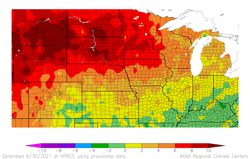
- Precipitation over the last 90 days has been only 25%–70% of normal in many areas of the Upper Midwest and Missouri River Basin. Contributing to the dry conditions have been above-normal maximum temperatures over the last 30 days across the entire northern portion of the Central U.S., which have really played a role in further drying the surface (Figure 2).
Figure 1. One-Week U.S. Drought Monitor Change Map (Since June 22, 2021)
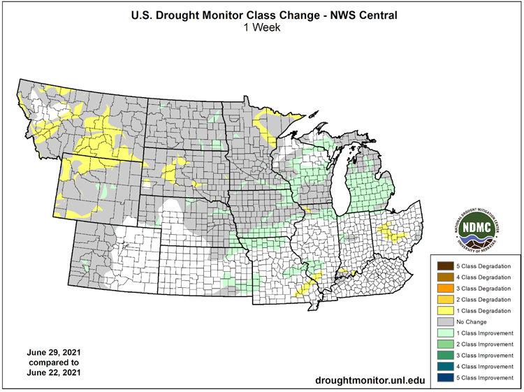
Figure 2. Departure from Normal Average Maximum Temperature (Last 30 Days): May 31–June 29, 2021
Impacts
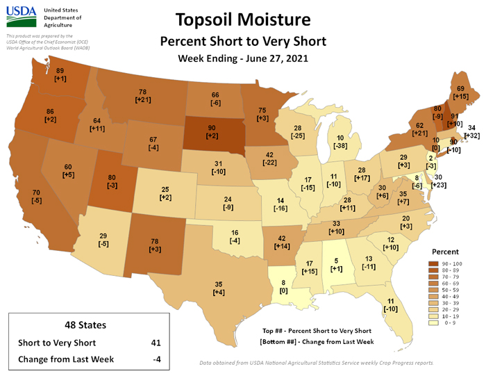
- Soil moisture and streamflow mimic the pattern of drought, with below-normal values in the Upper Missouri River Basin across Minnesota, Montana, North Dakota, South Dakota, and portions of Iowa. In South Dakota, 90% of the topsoil moisture is rated as short to very short, with 78% in Montana, 75% in Minnesota, 67% in Wyoming, and 66% in North Dakota, according to USDA National Agricultural Statistics Service (Figure 3).
- Crop conditions are worsening over the northwestern portions of the Corn Belt. Around a quarter of the corn is in poor to very poor condition in the Dakotas, and a third of the soybean crop is in poor to very poor condition as well. More significantly, spring wheat and barley conditions are the worst at this time of year for any year since 2000.
- Wildfires continue to be an issue across the Upper Missouri River Basin and the Upper Midwest. In North Dakota, there have been 72 fires in the last week. There are 45 county and 2 tribal burn restrictions across the state. Multiple counties across South Dakota, Minnesota, and Montana have put burn bans in place as well. Wildfires are a particular concern going into Independence Day weekend.
Figure 3. Topsoil Moisture Percent Short to Very Short (Week Ending June 27, 2021)
Outlooks and Potential Impacts
- In the short term (next two weeks), hot temperatures are expected to continue across the Central U.S., with triple-digit heat possible in some areas, particularly across the western parts of the region (Figure 4). Below-normal rainfall is also expected to continue to the west of the Mississippi River as well.
- Beyond the short term, the same pattern is likely to continue—July temperatures and overall July–September temperatures are expected to be above normal, and precipitation will likely remain below normal in the northern portions of the Central U.S. As a result of these outlooks, drought conditions are likely to persist and potentially worsen in some areas throughout the rest of the summer (Figure 5).
- The Significant Wildland Fire Potential Outlook for July and August 2021 shows above-normal wildland fire potential across Montana, Wyoming, North Dakota, South Dakota, and Minnesota (Figure 6).
- Corn crops will be reaching the tasseling stage within the next few weeks, and drought stress during tasseling can have a big impact on yield. Therefore, there is a significant amount of concern if the dry forecast comes to fruition. On the other hand, if soybeans receive some August precipitation, they could recover at least to a certain extent.
Figure 4. Risk of Hazardous Temperatures: July 9–15, 2021
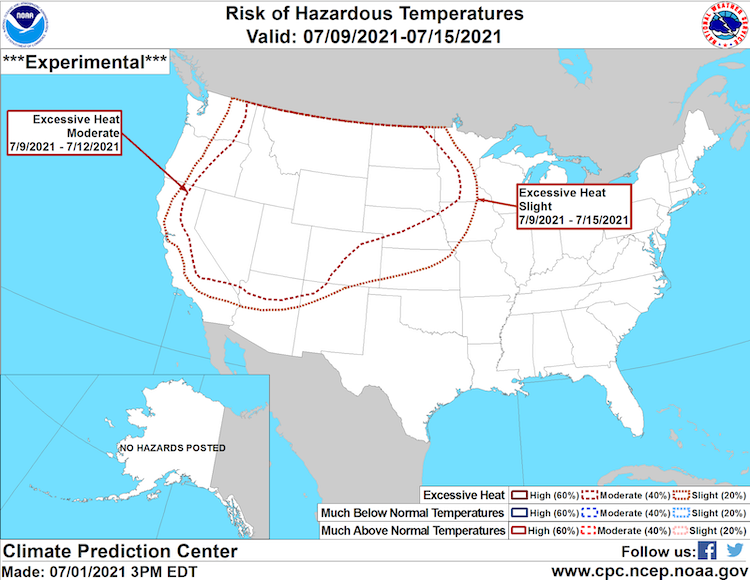
Figure 5. U.S. Seasonal Drought Outlook: June 17–September 30, 2021
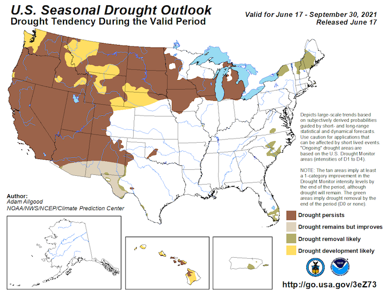
Figure 6. Significant Wildland Fire Potential Outlook for July 2021
For More Information
- NIDIS and its partners will issue future updates as conditions evolve.
- More local information is available from the following resources:
- The upcoming North Central U.S. Climate and Drought Summary & Outlook Webinar on July 15, 2021 will offer updated information about conditions, impacts, and outlooks.
Prepared By
Molly Woloszyn & Britt Parker
NOAA/National Integrated Drought Information System (NIDIS)
Dennis Todey
USDA Midwest Climate Hub
Doug Kluck
NOAA/National Centers for Environmental Information
This drought status update is issued in partnership between the National Oceanic and Atmospheric Administration (NOAA) and the U.S. Department of Agriculture (USDA) to communicate a potential area of concern for drought expansion and/or development within the North Central U.S. based on recent conditions and the upcoming forecast. NIDIS and its partners will issue future drought status updates as conditions evolve.

