Drought Conditions Will Likely Persist Into Next Year
Watch the recording from the August 19th North Central Climate and Drought Outlook Webinar for more information and details.
Key Points
- Despite significant rainfall over the past week in some parts of the region, drought severity and extent remained virtually unchanged according to the U.S. Drought Monitor. Drought remains widespread across much of the Upper Missouri River Basin (Montana, North Dakota, South Dakota, Wyoming), and across Minnesota and northern Iowa. 100% of Montana and North Dakota are in drought, as well as 97% of Minnesota, 95% of Wyoming, 94% of South Dakota, and 57% of Iowa.
- Wildfires, limited surface water (e.g., streams, rivers, livestock ponds), poor water quality, disruptions to recreation, low soil moisture, poor pasture conditions, crop yield loss, rural mental health issues, and damage to ecosystems are the major drought impacts being reported across the Upper Missouri River Basin and Upper Midwest.
- Short-term outlooks for the next two weeks show increased chances for above-normal rainfall for the Upper Missouri River Basin and other areas of the central U.S.
- Despite the potential for some short-term relief, drought conditions are expected to persist. Given the severity of the current drought, consecutive seasons with above-normal rain and snow events will be needed in order to see improvement in drought impacts. As a result, drought conditions will likely persist into next year, although some improvement might be possible.
Current U.S. Drought Monitor map for the National Weather Service Central Region with data valid for August 24, 2021. The U.S. Drought Monitor (USDM) is updated each Thursday to show the location and intensity of drought across the country. Drought categories show experts’ assessments of conditions related to dryness and drought including observations of how much water is available in streams, lakes, and soils compared to usual for the same time of year.
U.S. Drought Monitor Categories
Current U.S. Drought Monitor map for the National Weather Service Central Region with data valid for August 24, 2021. The U.S. Drought Monitor (USDM) is updated each Thursday to show the location and intensity of drought across the country. Drought categories show experts’ assessments of conditions related to dryness and drought including observations of how much water is available in streams, lakes, and soils compared to usual for the same time of year.
Current Conditions
- Despite significantly above-normal rainfall over the past week in some areas (Figure 1), drought severity and extent remained virtually unchanged according to the U.S. Drought Monitor (Figure 2).
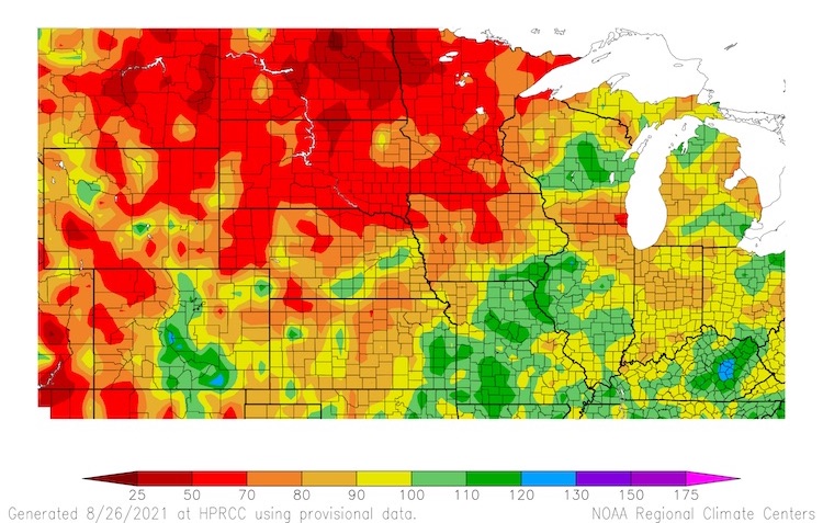
- When drought conditions are so severe, short-lived above-normal precipitation often does little to improve conditions, as much of the rain runs off and is not absorbed into the dry ground. Overall, precipitation remains significantly below normal at longer time scales (i.e., 6 to 12 months) (Figure 3).
- Drought remains widespread across much of the Upper Missouri River Basin (Montana, North Dakota, South Dakota, Wyoming), as well across Minnesota and northern Iowa. 100% of Montana and North Dakota are in drought, 97% of Minnesota, 95% of Wyoming, 94% of South Dakota, and 57% of Iowa. Exceptional drought (D4)—the worst level of drought—is impacting Montana, North Dakota, and Minnesota.
- In early August, exceptional drought (D4) was introduced into Minnesota, which was the first time the state has experienced a D4 drought since the U.S. Drought Monitor began in 2000.
- Outside of the areas with significant drought, some states have seen a recent expansion of drought and abnormally dry conditions. This includes (west to east) eastern Colorado, Nebraska, Kansas, eastern Iowa, northern Wisconsin, northern Michigan, and Indiana.
Figure 1. 7-Day Departure from Normal Precipitation (August 19–15, 2021)
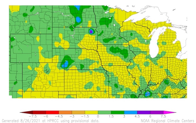
Figure 2. U.S. Drought Monitor 1-Week Change Map for North Central U.S.
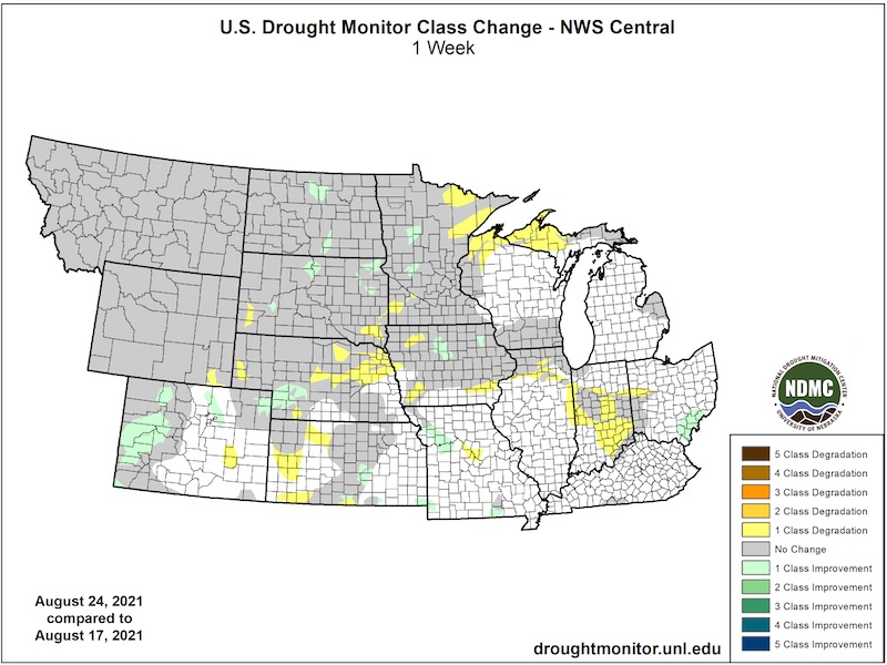
Figure 3. Percent of Normal Precipitation (12 months from August 26, 2020–August 25, 2021)
Impacts
- While the recent rainfall did not improve drought conditions, reports indicated that it did help temporarily reduce wildfire risk. However, active wildfires are still occurring in Montana, North Dakota, Wyoming, and northern Minnesota.
- Limited surface water (e.g., streams, rivers, livestock ponds) remains an issue across areas in drought. The U.S. Geological Survey reports that streamflow is much below normal at several gages in Minnesota and Iowa, as well as a few in Montana, Nebraska, North Dakota, South Dakota, and Wyoming. Limited surface water has effects on ecosystems that rely upon the water, as well as reduces the ability for water recreation. In rural areas across North Dakota and Montana, livestock ponds are dry or almost dry, and as a result, there are significant water quality issues (e.g., high sulfates).
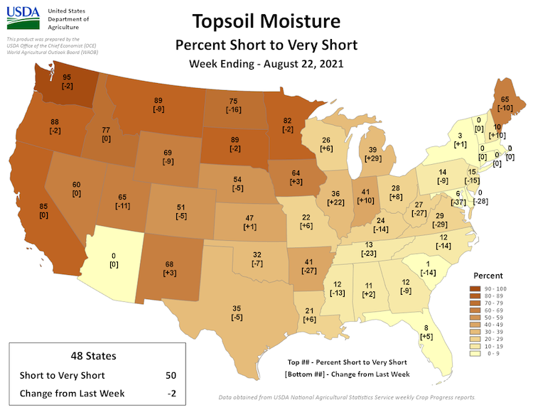
- Despite recent precipitation in some areas, soil moisture remains below normal across much of the north central U.S. According to the U.S. Department of Agriculture (USDA) National Agricultural Statistics Service (NASS), topsoil moisture is rated as short to very short across 89% of Montana, 89% of South Dakota, 82% of Minnesota, 75% of North Dakota, 69% of Wyoming, 64% of Iowa, and 54% of Nebraska (Figure 4).
- Livestock producers in Montana, North Dakota, South Dakota, and Wyoming have been struggling all summer to find adequate feed and water for their livestock. As a result, many producers have been hauling water to pastures, looking for alternative feed resources, weaning calves early, and selling or moving animals as needed. Pasture and ranch conditions are rated as poor to very poor across 97% of Montana, 84% in North Dakota, 81% in South Dakota, and 83% in Minnesota.
- The recent rainfall came very late in the growing season, but may still help soybean yield and the quality of corn, to a limited degree. Significant yield losses are being reported for hay, wheat, and barley, and potential losses in corn and soybeans in the worst drought areas (52% of soybeans and 48% of corn are rated in poor to very poor condition in North Dakota). However, a majority of states across the central U.S. have reported that corn and soybeans are in good to excellent condition.
Figure 4. Topsoil Moisture Percent Short to Very Short (Week Ending August 22, 2021)
Outlooks and Potential Impacts
- Short-term outlooks for the next two weeks show increased chances for above-normal rainfall for the Upper Missouri River Basin and other areas of the central U.S. (Figure 5). Temperatures for this time frame are likely to be above normal across much of the Midwest and Lower Missouri River Basin, which could limit drought improvement in some areas, and near to below normal across the Upper Missouri River Basin.
- Despite some potential short-term relief, drought conditions are expected to persist. Given the severity of the current drought, extended periods with above-normal rain and snow events will be needed in order to see improvement across the widespread and severe drought impacts. As a result, drought conditions will likely persist into next year, although some improvement might be possible (Figure 6).
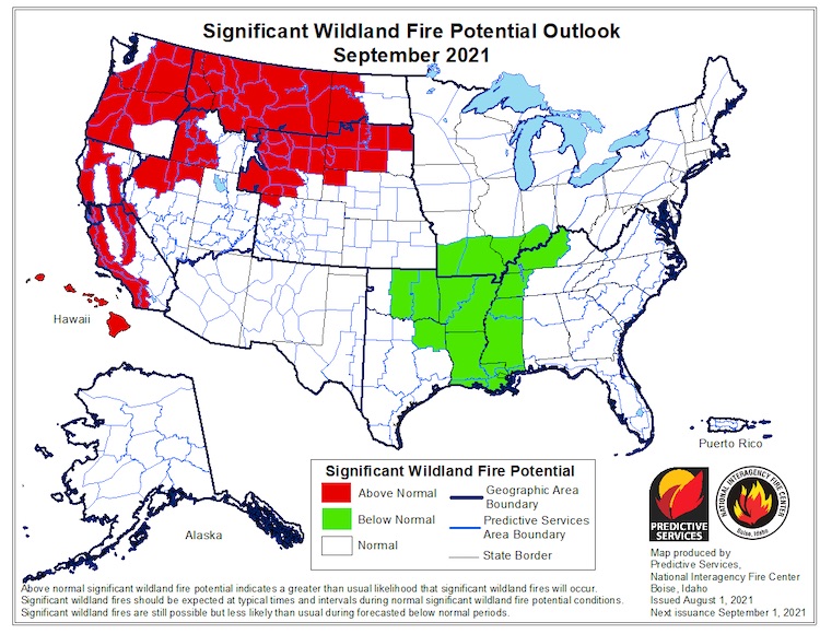
- The Significant Wildland Fire Outlook for September 2021 shows above-normal wildland fire potential across all of Montana, much of Wyoming, South Dakota, and western North Dakota (Figure 7).
- Potential impacts in the coming months include continued wildfire risk, issues with winter wheat and cover crop establishment, and continuation of limited surface water supply. Some impacts will likely ease due to cooler temperatures as we move into the fall and out of the growing season.
Figure 5. 8–14 Day Precipitation Outlook (Valid September 3–9, 2021)
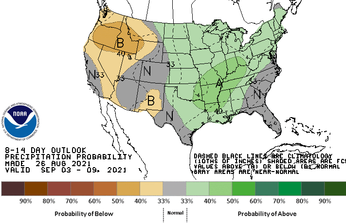
Figure 6. Percent of Normal Precipitation Needed to End Drought Conditions in 3 Months
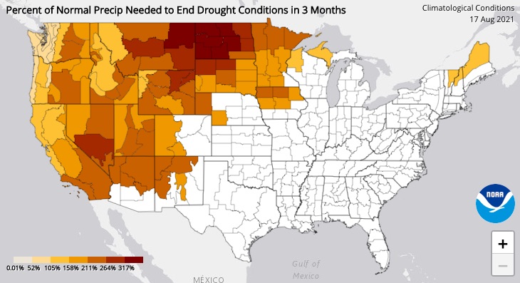
Figure 7. Significant Wildland Fire Potential Outlook for September 2021
For More Information
- NIDIS and its partners will issue future updates as conditions evolve.
- More local information is available from the following resources:
- The National Weather Service Central Region Regional Operations Center (in coordination with NOAA, the High Plains Regional Climate Center, USDA, and NIFC Geographic Area Coordination Centers) just released the 2021 Northern Plains Fall Hazard Outlook. This outlook highlights the increasing concern for continued or worsening drought conditions through this fall and into next year.
- The upcoming North Central U.S. Climate and Drought Summary & Outlook Webinar on September 16, 2021 will offer updated information about conditions, impacts, and outlooks.
Prepared By
Molly Woloszyn & Britt Parker
NOAA/National Integrated Drought Information System (NIDIS)
Dennis Todey & Dannele Peck
USDA Midwest and Northern Plains Climate Hub
Doug Kluck
NOAA/National Centers for Environmental Information
This drought status update is issued in partnership between the National Oceanic and Atmospheric Administration (NOAA) and the U.S. Department of Agriculture (USDA) to communicate a potential area of concern for drought expansion and/or development within the North Central U.S. based on recent conditions and the upcoming forecast. NIDIS and its partners will issue future drought status updates as conditions evolve.

