Drought Persists in Portions of North Central U.S., with Flash Drought in Missouri
This Drought Status Update is based on information provided during the May 18, 2023 North Central U.S. Climate and Drought Outlook Webinar. View the webinar for more details.
Key Points
- Despite improvements in some areas, several states, primarily in the Missouri River Basin, are still experiencing drought conditions. As of May 16, 22% of the region is in some level of drought (moderate to exceptional), with the most intense conditions in Kansas and Nebraska, according to the U.S. Drought Monitor.
- Drought has rapidly intensified (often referred to as “flash drought”) across portions of Missouri, particularly over the last month. Some areas in central Missouri went from having no drought in early- to mid-April to extreme drought (D3) by early May.
- A majority of the Midwest remains drought free (most of Illinois, Indiana, Kentucky, Michigan, Ohio, and Wisconsin).
- Drought impacts are being felt primarily across Kansas, Nebraska, and Missouri. Impacts include very poor winter wheat conditions and loss of crops, limited topsoil moisture for planting and germination, poor pasture conditions and low stock ponds, municipal water restrictions, and wildfires in eastern Nebraska.
- Looking towards the end of May (May 25–31), the outlook shows a chance for above-normal temperatures across the entire north central U.S. In areas where there is little to no rainfall, this could mean increased evaporative demand and loss of surface moisture.
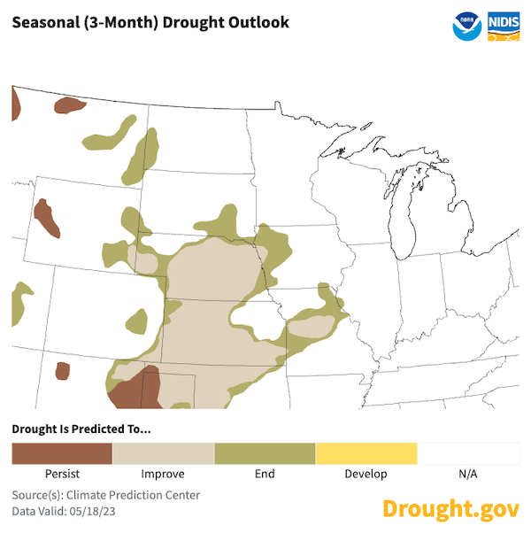
- The seasonal drought outlook shows that by the end of August, drought will likely remain but improve across Kansas, Nebraska, and Missouri, and therefore, drought impacts are likely to continue and potentially increase due to higher summer temperatures and evaporative demand.
Current U.S. Drought Monitor map for the National Weather Service Central Region with data valid for May 16, 2023. The U.S. Drought Monitor depicts the location and intensity of drought across the country. The map uses 5 classifications: Abnormally Dry (D0), showing areas that may be going into or are coming out of drought, and four levels of drought (D1–D4).
U.S. Drought Monitor Categories
Abnormally Dry (D0)
Abnormally Dry (D0) indicates a region that is going into or coming out of drought. View typical impacts by state.
Moderate Drought (D1)
Moderate Drought (D1) is the first of four drought categories (D1–D4), according to the U.S. Drought Monitor. View typical impacts by state.
Severe Drought (D2)
Severe Drought (D2) is the second of four drought categories (D1–D4), according to the U.S. Drought Monitor. View typical impacts by state.
Extreme Drought (D3)
Extreme Drought (D3) is the third of four drought categories (D1–D4), according to the U.S. Drought Monitor. View typical impacts by state.
Exceptional Drought (D4)
Exceptional Drought (D4) is the most intense drought category, according to the U.S. Drought Monitor. View typical impacts by state.
Current U.S. Drought Monitor map for the National Weather Service Central Region with data valid for May 16, 2023. The U.S. Drought Monitor depicts the location and intensity of drought across the country. The map uses 5 classifications: Abnormally Dry (D0), showing areas that may be going into or are coming out of drought, and four levels of drought (D1–D4).
The U.S. Drought Monitor is updated weekly on Thursdays, with data valid through the previous Tuesday at 7 a.m.
Current Conditions
- Despite improvements in some areas, some states across the north central U.S., primarily Missouri River Basin states, are still experiencing drought conditions. As of May 16, 22% of the region is in some level of drought (moderate to exceptional), with the most intense conditions in Kansas and Nebraska, according to the U.S. Drought Monitor.
- 81% of Kansas is experiencing drought, with 35% of the state in exceptional (D4) drought. This past week brought some much-needed rain to northwest Kansas, reducing the intensity of drought in this area by one category on the U.S. Drought Monitor. However, portions of central Kansas have seen drought intensify over the last 8 weeks (Figure 1).
- Just over 86% of Nebraska is in some level of drought, but the intensity of drought is lower than it is in Kansas, with only 5% of the state in exceptional drought (in northeast Nebraska). Significant rainfall in western and central Nebraska this past week helped provide a 32% reduction in extreme drought (D3) across the state.
- Drought has rapidly intensified across portions of Missouri over the last 8 weeks, with much of this intensification happening within the last month. Some areas in central Missouri went from having no drought in early to mid-April to extreme drought (D3) by early May (4-category change).
- Figure 1 also shows the improvement in drought conditions across many areas over the last 8 weeks, most notably in Montana, North Dakota, South Dakota, eastern Colorado, western Nebraska, southeastern Minnesota, and northern Iowa. A majority of the Midwest remains drought free (most of Illinois, Indiana, Kentucky, Michigan, Ohio, and Wisconsin).
- Areas with drought improvement have received 130%–300% of normal precipitation over the last 30 days (Figure 2). On the other hand, many areas including Missouri, eastern Kansas, eastern Nebraska, and other states that are currently drought free (Michigan, Wisconsin, Illinois) have received only 5%–50% of normal precipitation.
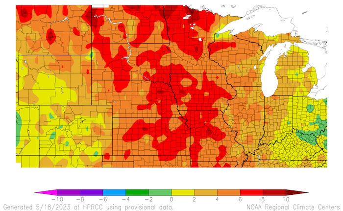
- Thankfully, near- to cooler-than-normal temperatures across the region over the last 30 days have helped limit the amount of moisture lost from the surface (Figure 3). However, May temperatures have been above normal across a majority of the region by 4–10°F (Figure 4) and are forecast to remain through the end of the month (see Figure 9), which could increase moisture loss from the surface in the absence of rain.
Figure 1: 8-Week U.S. Drought Monitor Change Map (Since March 21, 2023)
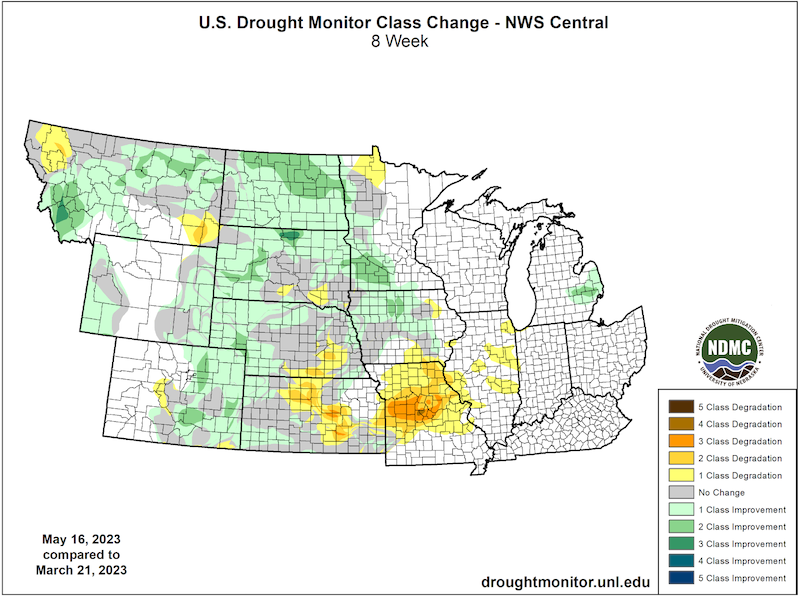
Figure 2: 30-Day Percent of Normal Precipitation: April 18–May 17, 2023
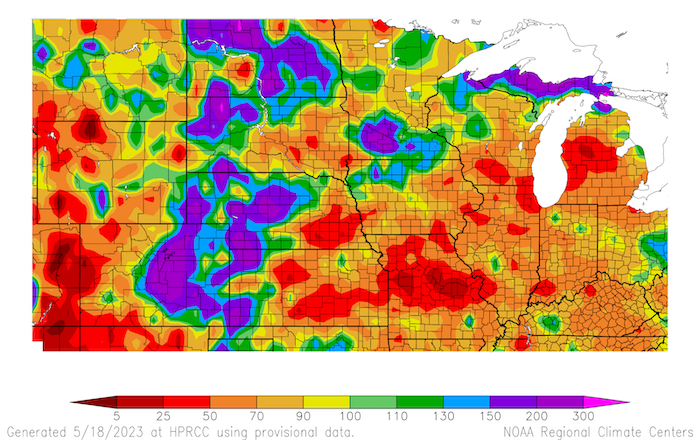
Figure 3: 30-Day Departure from Normal Temperature: April 18–May 17, 2023
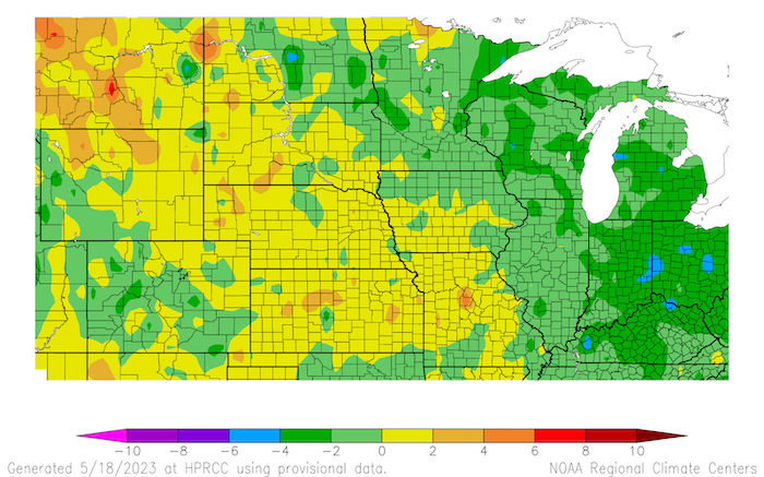
Figure 4: 14-Day Departure from Normal Temperature: May 4–17, 2023
Impacts
- Topsoil moisture is reported to be short to very short across 65% of Kansas, 46% of Nebraska, and 40% of Missouri, as of May 14 (Figure 5). Overall, a majority of other states in the north central U.S. are not reporting short to very short topsoil moisture.
- Drought over the winter and into spring greatly affected the winter wheat crop across Kansas, Nebraska, Colorado, and South Dakota (Figure 6). The wheat did not germinate in the winter due to dry conditions. Many farmers have decided this year’s wheat is not worthy of cutting, and the crop has been abandoned, meaning significant loss of yield.
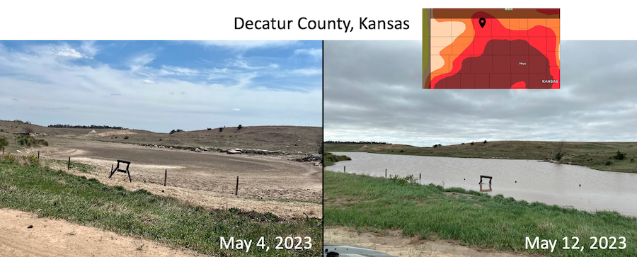
- The dry conditions are also greatly impacting pasture conditions and livestock production in Kansas, Nebraska, and Missouri. Forage production is down, and producers have been selling their livestock, hauling water due to low stock ponds, and using last year’s hay. Thankfully, recent rainfall has provided some short-term gains in surface water for livestock in some areas (Figure 7).
- Some farmers in Kansas are shifting their crop management due to the lack of rain and limited moisture for planting corn. Nebraska farmers are worried there won’t be enough moisture to germinate seeds this season.
- There are some municipalities taking action to conserve water due to the drought. Wichita residents were asked to conserve water in mid-April as their supply (Cheney Lake) was only at 80% capacity. Norton, Kansas (northwest Kansas) began water restrictions on April 28 instead of waiting until Memorial Day. Also, reports have shown decreased groundwater levels in Kansas and Nebraska over the last year due to drought.
- The Kansas Department of Wildlife and Parks is warning recreational boaters that water levels across the state are low and that caution should be taken when boating.
- In Seward County, Nebraska, a Condition Monitoring Observer Reports (CMOR) reporter said there are ponds and creeks dry that they have never seen dry, even during the drought of 2012.
- The Upper Missouri River has seen increased runoff this spring due to late season snowpack and subsequent melting. For April, runoff was 4.7 million acre-feet, which is 159% of average for the Basin above Sioux City, Iowa.
- In Barton County, Kansas, many bird species have chosen other migratory patterns this year due to drought and have not arrived at Cheyenne Bottoms. Less-mobile wildlife like turtles and reptiles are doing their best to survive the dry conditions.
- Fire has been an issue in portions of eastern Nebraska. In mid-April, at least three fires jumped the Missouri River from Iowa and burned hundreds of acres in eastern Nebraska near Omaha and Lake Waconda in southeast Nebraska.
Report your drought impacts through the Condition Monitoring Observer Reports (CMOR):
Figure 5: Topsoil Moisture (Percent Rated Short to Very Short) – Week ending May 14, 2023
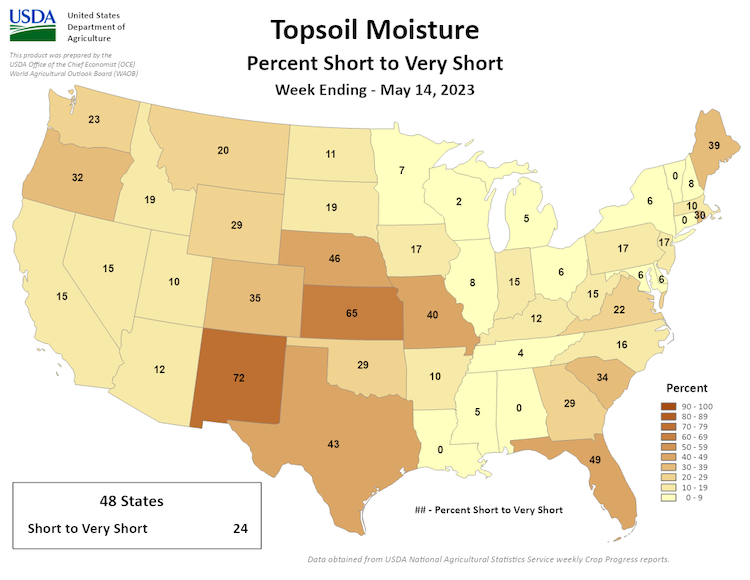
Figure 6: Winter Wheat Conditions (Percent Poor to Very Poor) – As of May 14, 2023
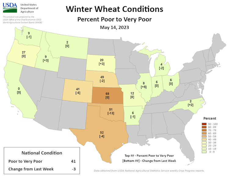
Figure 7: Photo of a Stock Pond in Decatur County, Kansas (Northeast Kansas) on May 4 vs. May 12
Outlook and Potential Impacts
- The forecast for total precipitation accumulation over the next seven days shows the possibility of a few inches of rainfall in southern Kansas. However, many of the dry areas are not expected to get significant rain (Figure 8).
- Looking towards the end of May (May 26–June 1), the outlook shows a chance for above-normal temperatures to continue across the entire north central U.S. (Figure 9). In areas where there is little to no rainfall this could mean increased evaporative demand and loss of surface moisture. During this same time, rain could be above normal in portions of the Plains, while below normal further east in the Midwest (Figure 10).
- The outlook for June shows the chance for continued above-normal precipitation in the western portions of the north central U.S., which could help some areas in drought. However, the remainder of the region has equal chances for below-, near-, or above-normal precipitation (Figure 11).
- The seasonal drought outlook shows that by the end of August, drought will likely remain but improve across Kansas, Nebraska, and Missouri (Figure 12), and therefore, drought impacts are likely to continue and potentially increase due to higher summer temperatures and evaporative demand.
Figure 8: Quantitative Precipitation Forecast for the next 7 days (May 18-25, 2023)
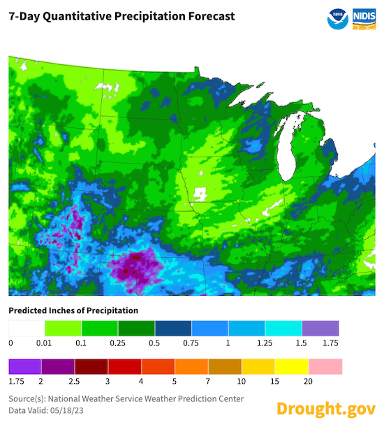
Figure 9: 8–14 Day Temperature Outlook (Valid May 26–June 1, 2023)

Figure 10: 8-14 Day Temperature Outlook (Valid May 26–June 1, 2023)
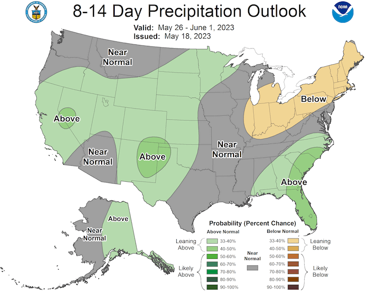
Figure 11: Monthly Precipitation Outlook for June 2023
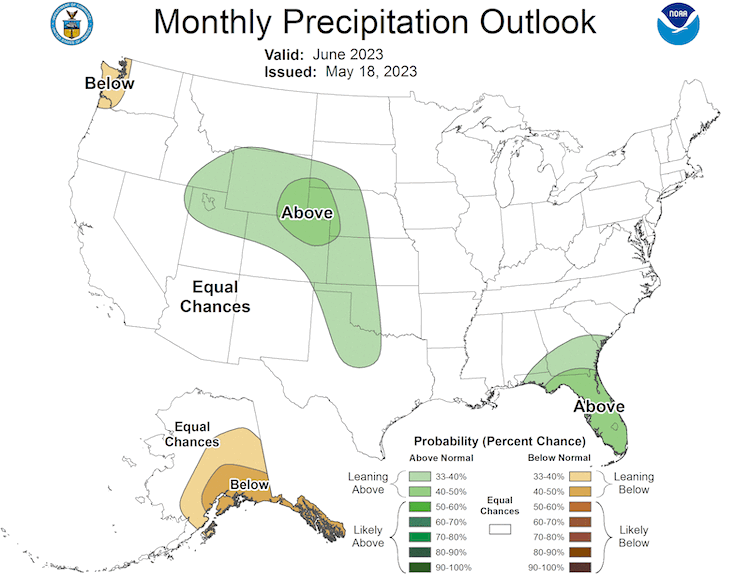
Figure 12: Seasonal Drought Outlook for May 18–August 31, 2023
For More Information
- NIDIS and its partners will issue future updates as conditions evolve.
- A special thank you to the state climate offices in the Midwest and Missouri River Basin for providing local information on drought conditions and impacts included in the webinar and on this report.
- This Drought Status Update is based on information provided during the May 18, 2023 North Central U.S. Climate and Drought Outlook webinar. View the webinar for more details.
- The next North Central U.S. Climate and Drought Summary & Outlook Webinar will take place on June 15, 2023 and will offer updated information about conditions, impacts, and outlooks.
- More local information is available from the following resources:
- To report or view local drought impact information:
- Report your Drought Impacts through Condition Monitoring Observer Reports (CMOR).
- View CoCoRaHS Condition Monitoring reports.
Prepared By
Molly Woloszyn
NOAA/National Integrated Drought Information System (NIDIS), CIRES/CU Boulder
Doug Kluck
NOAA/National Centers for Environmental Information
Dennis Todey & Laurie Nowatzke
USDA Midwest Climate Hub
Dannele Peck
USDA Northern Plains Climate Hub
Audra Bruschi
NOAA/National Weather Service (NWS)
Kevin Low
NOAA/NWS Missouri Basin River Forecast Center
Gannon Rush, Rezaul Mahmood
High Plains Regional Climate Center/University of Nebraska-Lincoln
Melissa Widhalm
Midwestern Regional Climate Center/Purdue University
This Drought Status Update is issued in partnership between the National Oceanic and Atmospheric Administration (NOAA) and the U.S. Department of Agriculture (USDA) to communicate a potential area of concern for drought expansion and/or development within the North Central U.S. based on recent conditions and the upcoming forecast. NIDIS and its partners will issue future drought status updates as conditions evolve.

