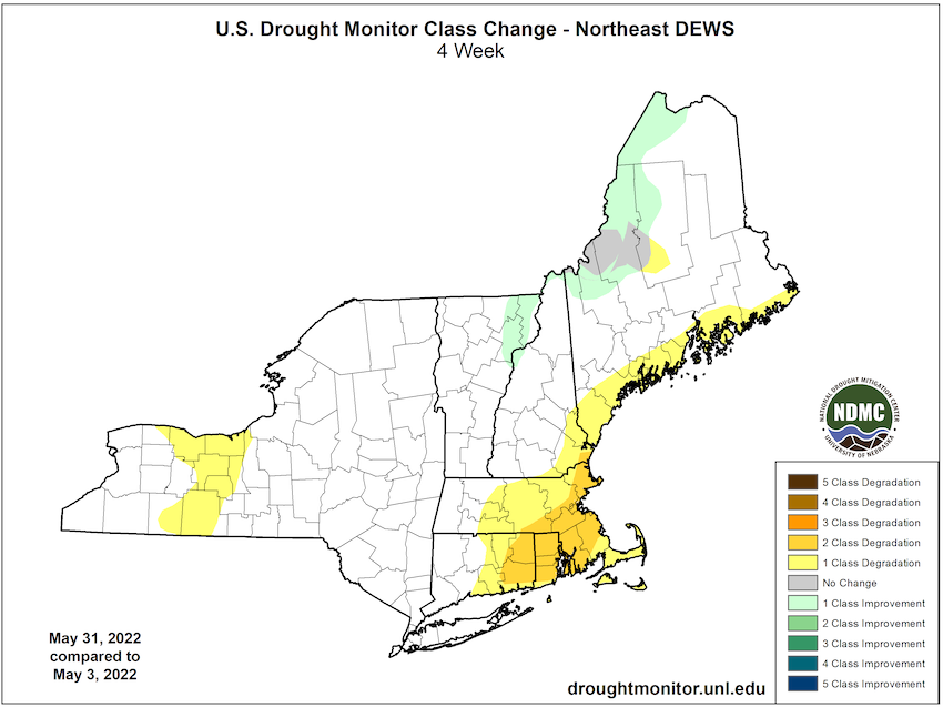
While rain provided relief to parts of Maine, drought intensified in southeast New England.
For more details, see the Northeast Drought Early Warning System Dashboard.
Key Points
- Rain relieved some long-term dryness in parts of northwestern Maine, but both Moderate Drought (D1) and Abnormally Dry conditions (D0) held for some counties.
- Moderate Drought (D1) expanded further south into eastern counties of Connecticut and over most of Rhode Island.
- Moderate Drought (D1) extended into southeastern New Hampshire and counties in southeast Massachusetts.
- Abnormally Dry conditions (D0) expanded west to the Connecticut River Valley in both Massachusetts and Connecticut as it held fast along the rest of the New England coast, Cape Cod, and the Islands.
- Abnormally Dry conditions (D0) continued in portions of western New York.
- Regional Spring (March–May) precipitation statistics:
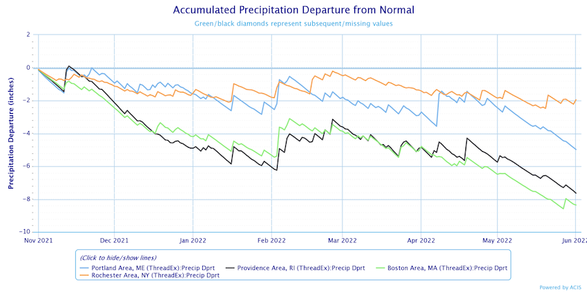
- Boston had its 14th driest March–May; precipitation was only 59% of normal.
- Providence, RI precipitation was 69% of normal
- Portland, ME precipitation was 75% of normal
- Rochester, NY precipitation was 78% of normal
- For additional details on May temperatures and precipitation in the Northeast, see the Northeast Regional Climate Center blog.
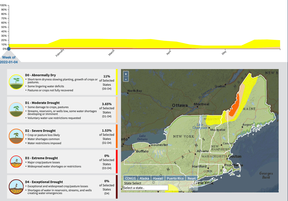
Current U.S. Drought Monitor map for the Northeast Drought Early Warning System with data valid for May 31, 2022. The U.S. Drought Monitor is updated each Thursday to show the location and intensity of drought across the country.
According to the latest U.S. Drought Monitor:
- Moderate drought (D1) conditions exist in 4.82% of the region.
- Abnormally dry (D0) conditions exist in 19.81% of the region.
U.S. Drought Monitor Categories
Current U.S. Drought Monitor map for the Northeast Drought Early Warning System with data valid for May 31, 2022. The U.S. Drought Monitor is updated each Thursday to show the location and intensity of drought across the country.
According to the latest U.S. Drought Monitor:
- Moderate drought (D1) conditions exist in 4.82% of the region.
- Abnormally dry (D0) conditions exist in 19.81% of the region.
Current Conditions
U.S. Drought Monitor 4-Week Change Map
Animation: 2022 U.S. Drought Monitor Conditions in the Northeast
Accumulated Precipitation Departure from Normal
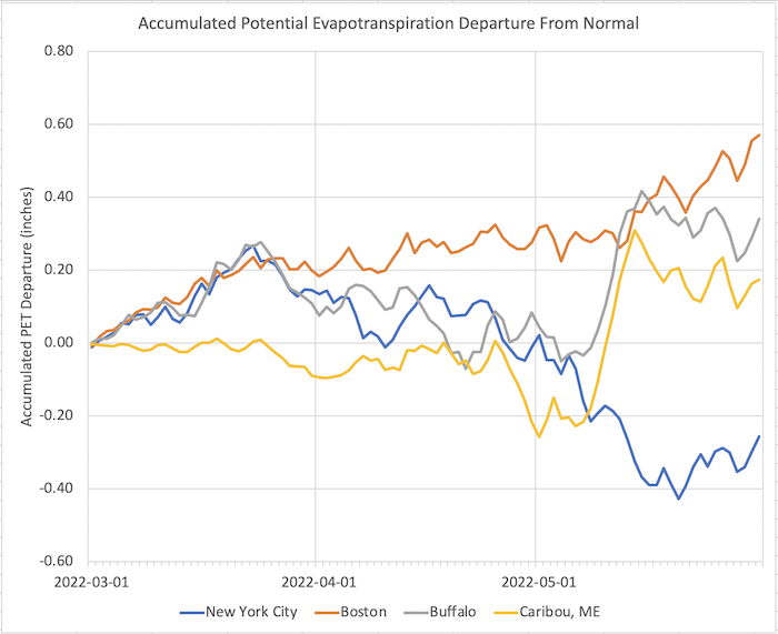
Accumulated Potential Evapotranspiration (PET) Departure from Normal
State-Reported Impacts
Connecticut
- May 22, 2022: CT Post – "Climate Education Necessary for CT Future"
Maine
-
May 27, 2022: Bangor Daily News – Aroostook’s Summer Temperatures
Massachusetts
- May 28, 2022: WBUR – State Officially in Drought
New York
- May 26, 2022: The Citizen (Auburnpub.com) – The Spongy Moth and Drought
Outlooks
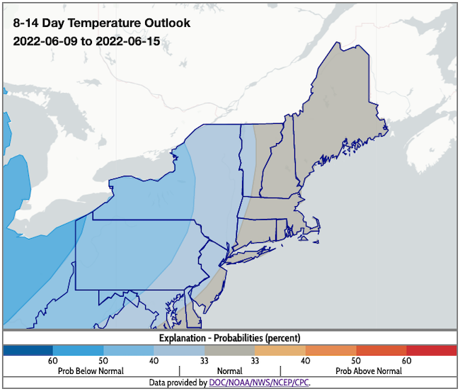
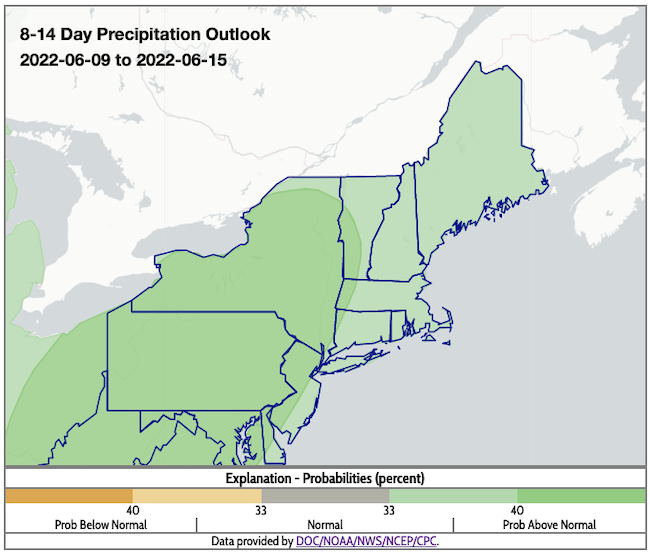
- According to the Climate Prediction Center's 8–14 day outlook (valid June 9–15), the entire Northeast has a greater likelihood of above-normal precipitation. Odds favor below-normal temperatures for New York, western Vermont, far-western Massachusetts, and the northwest corner of Connecticut, with near-normal conditions for the rest of the region.
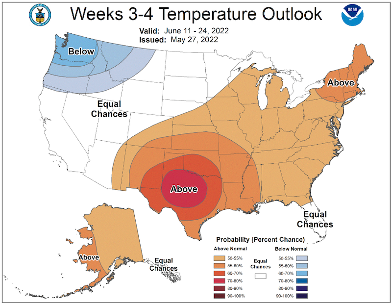
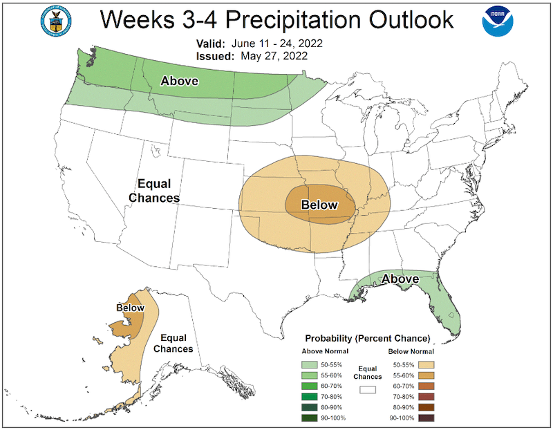
- The week 3–4 outlook (valid June 11–24) favors above-normal temperatures throughout the Northeast. The entire region has equal chances of above- or below-normal precipitation.
8–14 Day Temperature Outlook
8–14 Day Precipitation Outlook
Temperature Outlook Week 3–4
Precipitation Outlook Week 3–4
What We Are Watching
The warm season is here. Information sharing is more important than ever for our region. Share drought impacts, and sign up for drought alert emails.
NIDIS and Northeast DEWS News
- Northeast DEWS 2022–2026 Strategic Action Plan Released
- NIDIS Soil Moisture Quarterly Seminar Series – Register for the June 14 webinar
Additional Resources
- Your local National Weather Service office
- NOAA Regional Climate Services Monthly Webinar Series (next webinar is on June 30)
- USDA Northeast Climate Hub
- USGS New England and New York Water Science Centers
Use these sites to keep tabs on drought degradation and improvements in the areas outside of the Northeast DEWS borders:
Contacts for More Information
Sylvia Reeves
Regional Drought Information Coordinator (Northeast DEWS)
NOAA/CIRES/National Integrated Drought Information System (NIDIS)
Email: sylvia.reeves@noaa.gov
Ellen L. Mecray
Regional Climate Services Director, Eastern Region
NOAA/NESDIS/National Centers for Environmental Information
Email: Ellen.L.Mecray@noaa.gov
Prepared By
Sylvia Reeves
NOAA/National Integrated Drought Information System (NIDIS), CIRES
Samantha Borisoff, Jessica Spaccio, Keith Eggleston, Art DeGaetano
Northeast Regional Climate Center
Ellen Mecray
Regional Climate Services Director, Eastern Region, NOAA
David Hollinger
USDA Climate Hubs
Gardner Bent
USGS New England Water Science Center
In partnership with National Weather Service Offices of the Northeast and State Climate Offices of the Northeast.
This drought early warning update is issued in partnership between the National Oceanic and Atmospheric Administration (NOAA), U.S. Geological Survey, and the U.S. Department of Agriculture (USDA) to communicate concern for drought expansion and intensification within the Northeast U.S. based on recent conditions and the forecasts and outlooks. NIDIS and its partners will issue future Drought Early Warning Updates as conditions evolve.
