U.S. Caribbean Drought Sparks Fires and Water Rationing; Dry Fall Ahead.
Key Points
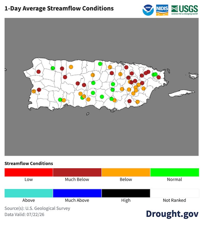
- Regional: Following a wetter-than-normal late winter and early spring, conditions across the U.S. Caribbean dried significantly throughout May, June, and July. The region is experiencing near-record warmth and dryness, which has triggered grass fires and critically low stream levels. Depleting water supplies in major reservoirs and underground wells are causing significant economic losses across the agricultural sector.
- Puerto Rico Impacts: In Puerto Rico, diminishing surface and groundwater levels have triggered water rationing for agricultural users in the south-central and southwest regions, as well as for residents in parts of the northeast. The frequency of brush fires has surged, with more than 300 reports in July alone. These wildfires have been notably intense and expansive, causing rare damage to local infrastructure. Furthermore, soils continue to dry out, and vegetation stress remains severe, particularly along the southern coast.
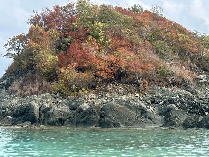
- U.S. Virgin Islands Impacts: Across the Virgin Islands, vegetation shows clear signs of stress, and there is not enough water for residents to fill their cisterns. The dry soils and lack of precipitation impacted specialty, row, and fruit tree farmers.
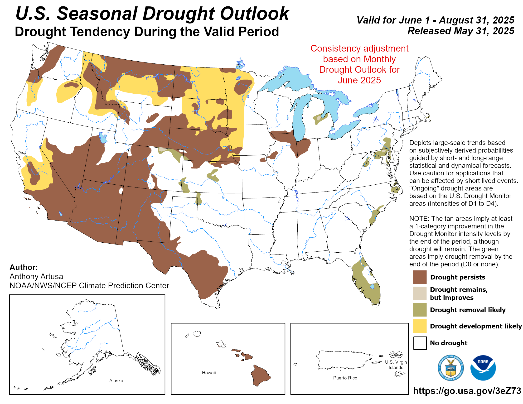
- Looking ahead: Drought conditions are likely to persist or expand through early fall. As El Niño strengthens in the Pacific, the probability of experiencing significant tropical waves or cyclones will decrease.
See below for additional details on current conditions, impacts (including streamflow and soil moisture), and outlooks.
U.S. Drought Monitor map for Puerto Rico and the U.S. Virgin Islands, as of July 21, 2026. The U.S. Drought Monitor is updated each Thursday to show the location and intensity of drought across the country.
The map uses 5 classifications: Abnormally Dry (D0), showing areas that may be going into or are coming out of drought, and four levels of drought (D1–D4).
A drought index combines multiple drought indicators (e.g., precipitation, temperature, soil moisture) to depict drought conditions. For some products, like the U.S. Drought Monitor, authors combine their analysis of drought indicators with input from local observers. Other drought indices, like the Standardized Precipitation Index (SPI), use an objective calculation to describe the severity, location, timing, and/or duration of drought.
Learn MorePeriods of drought can lead to inadequate water supply, threatening the health, safety, and welfare of communities. Streamflow, groundwater, reservoir, and snowpack data are key to monitoring and forecasting water supply.
Learn MoreDrought can reduce the water availability and water quality necessary for productive farms, ranches, and grazing lands, resulting in significant negative direct and indirect economic impacts to the agricultural sector. Monitoring agricultural drought typically focuses on examining levels of precipitation, evaporative demand, soil moisture, and surface/groundwater quantity and quality.
Learn MoreU.S. Drought Monitor
D0 - Abnormally Dry
Abnormally Dry (D0) indicates a region that is going into or coming out of drought, according to the U.S. Drought Monitor. View typical impacts by state.
D1 – Moderate Drought
Moderate Drought (D1) is the first of four drought categories (D1–D4), according to the U.S. Drought Monitor. View typical impacts by state.
D2 – Severe Drought
Severe Drought (D2) is the second of four drought categories (D1–D4), according to the U.S. Drought Monitor. View typical impacts by state.
D3 – Extreme Drought
Extreme Drought (D3) is the third of four drought categories (D1–D4), according to the U.S. Drought Monitor. View typical impacts by state.
D4 – Exceptional Drought
Exceptional Drought (D4) is the most intense drought category, according to the U.S. Drought Monitor. View typical impacts by state.
U.S. Drought Monitor map for Puerto Rico and the U.S. Virgin Islands, as of July 21, 2026. The U.S. Drought Monitor is updated each Thursday to show the location and intensity of drought across the country.
The map uses 5 classifications: Abnormally Dry (D0), showing areas that may be going into or are coming out of drought, and four levels of drought (D1–D4).
The U.S. Drought Monitor is updated weekly on Thursday morning, with data valid through that Tuesday at 7 a.m. EDT.
A drought index combines multiple drought indicators (e.g., precipitation, temperature, soil moisture) to depict drought conditions. For some products, like the U.S. Drought Monitor, authors combine their analysis of drought indicators with input from local observers. Other drought indices, like the Standardized Precipitation Index (SPI), use an objective calculation to describe the severity, location, timing, and/or duration of drought.
Learn MorePeriods of drought can lead to inadequate water supply, threatening the health, safety, and welfare of communities. Streamflow, groundwater, reservoir, and snowpack data are key to monitoring and forecasting water supply.
Learn MoreDrought can reduce the water availability and water quality necessary for productive farms, ranches, and grazing lands, resulting in significant negative direct and indirect economic impacts to the agricultural sector. Monitoring agricultural drought typically focuses on examining levels of precipitation, evaporative demand, soil moisture, and surface/groundwater quantity and quality.
Learn MoreThis update is based on data available as of 5:00 p.m. AT on Tuesday, July 21, 2026. We acknowledge that conditions are evolving.
Current Drought Conditions
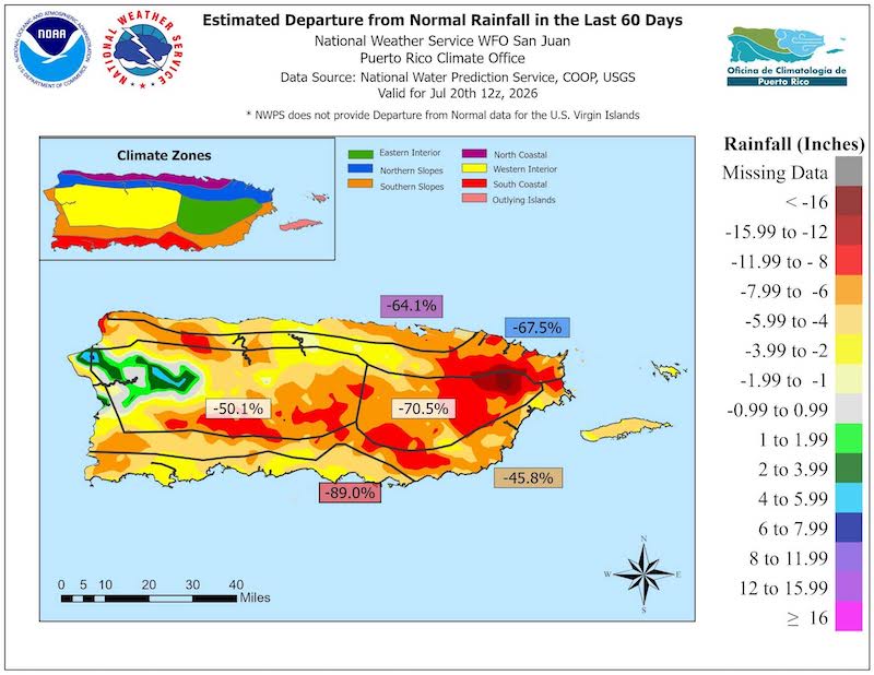
- Rainfall deficits are widespread throughout Puerto Rico, with most regions receiving less than 60% of normal precipitation over the past 60 days. Southern and southwestern areas received less than 20% of typical rainfall, representing a deficit of 3–6 inches, while the El Yunque rainforest area reports levels 8–14 inches below average. Meanwhile, localized precipitation in the west-northwest helped mitigate drought conditions.
- Puerto Rico and the U.S. Virgin Islands experienced record or near-record warmth and dryness. For example, San Juan in Puerto Rico is experiencing their driest July on record and fourth warmest on record, and Juncos is experiencing their second driest and warmest July on record. In the U.S. Virgin Islands, both Henry E. Rohlsen Airport (St. Croix) and Cyril E. King Airport (St. Thomas) recorded their driest June on record. This period also marks the second driest May–July for the islands since record -keeping began in the early 1950s.
- The U.S. Drought Monitor indicates Severe Drought (D2) across Puerto Rico's southern plains from Cabo Rojo to Cidra, with Moderate Drought (D1) spanning the eastern and southern half, and Abnormally Dry (D0) conditions in the north-central and northwest. The entire U.S. Virgin Islands territory is currently classified in Extreme Drought (D3).
Widespread Early Summer Dryness in Puerto Rico, with Localized Rain in the West
Agriculture, Forest, and Wildfire Impacts for Puerto Rico and the U.S. Virgin Islands
Report your Impacts: To report the effects of dry conditions on your farm projects for future Drought Updates, use the Drought Condition Monitoring Observations and Reports (CMOR) tool or join the Caribbean Climate Hub reporting chat on WhatsApp.
Puerto Rico Impacts
- North:
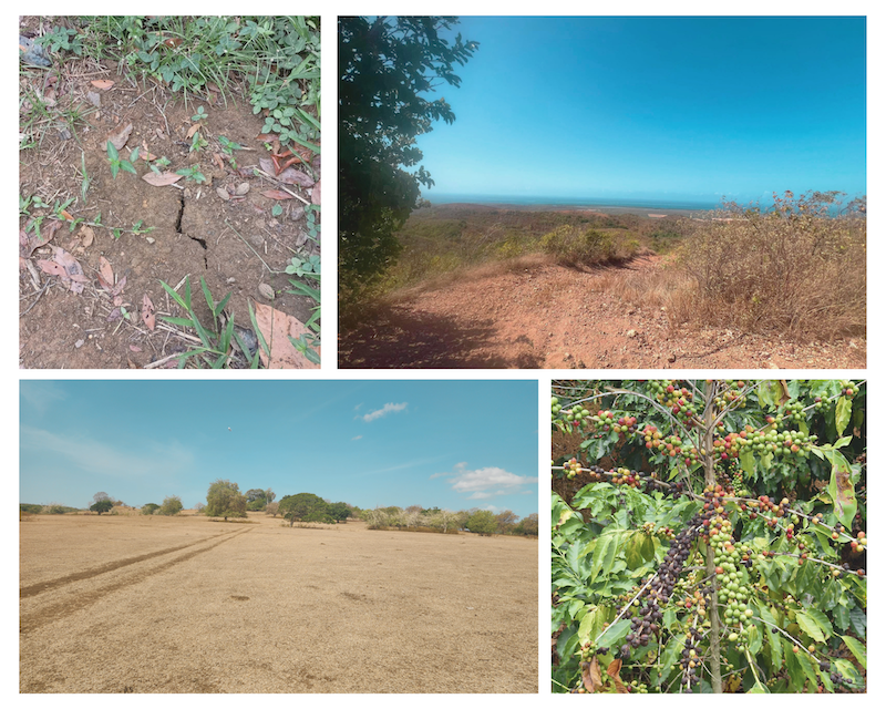
- Canóvanas: Producers report record-level dryness, resulting in dry, cracked soils. Fruit loss is occurring prematurely for breadfruit (pana) and avocados, with some avocados showing signs of dehydration. Cacao trees are experiencing leaf yellowing. Young banana plants are wilting due to prolonged water stress.
- Central Interior: Lack of rainfall, dry conditions, and high temperatures led to extensive soil cracking across the region, impacting crop growth and health.
- Cayey: Fruit trees like breadfruit (pana) and rose apple (pomarrosa) are losing leaves, while others show stress despite blooming. Pasture growth has stalled for a month, leaving some grazing areas completely dry.
- Orocovis: Drought conditions have reduced citrus production below normal levels, with reports of pest infestations affecting mandarin trees.
- Caguas: Prolonged dry conditions and high temperatures delayed crop growth and negatively impacted leafy vegetables like lettuce. Some farmers are hauling water to prevent losses.
- Aguas Buenas: Producers report widespread soil cracking and unusually thin plantains. Producers are leaving weeds to conserve moisture, though soils fail to retain moisture even after rain. A wildfire occurred near agricultural lands.
- Gurabo: Local streams have dried up or seen significant reductions in flow.
- Lares: Insufficient rainfall has only wetted the soil surface, severely impacting new plantings. Young trees are failing or dying, leading to significant losses in stock and labor.
- South: Pastures are drying, with reports of burned grass in Juana Díaz, Salinas, and Santa Isabel. Reduced streamflow in the Río Grande de Loíza (San Lorenzo to Patillas) has widened the river channel. Plantain crops in Juana Díaz remain stressed but are viable due to irrigation.
- South and Southwest: Although dry conditions were expected during this time of year, the severity of the drought exceeded expectations in this region. Drought has impacted pasture production, crop growth, and reservoir levels, leading to economic losses.
- Irrigation district managers report continued declines in reservoir levels across the southern irrigation systems. Agricultural water rationing is in effect throughout the southern districts and is most severe in the southwest. The Southwest District has implemented water rationing for farmers (three days/week). In the Juana Díaz District, water flow has been reduced by approximately 5% as the Lago Guayabal reservoir continues to lose water. In the Patillas District, streams are contributing only 25% of their normal flow.
- Coffee beans are ripening prematurely, impacting quality and flavor.
- Ranchers face forage shortages in Lajas, forcing increased reliance on supplemental feed and depleting hay reserves.
- Sierra Bermeja forests show defoliation and soil cracking (1–2 inches).
Dry Conditions Across Puerto Rico
U.S. Virgin Islands Impacts
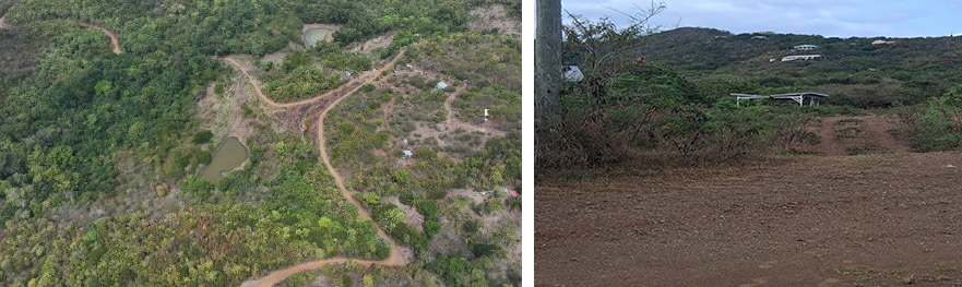
- Across the U.S. Virgin Islands, high winds and lack of precipitation are causing severe soil cracking and vegetation distress. Farmers report unusually harsh conditions as ponds deplete. Furthermore, irrigation supply delays due to tariffs are exacerbating stress on the agricultural community.
- St. Thomas: Livestock and poultry farmers face limited feed access due to dying Guinea grass. Groundwater levels are not improving, and water access for agricultural needs remains limited despite filling the fairgrounds cistern with a 2,000-gallon water truck.
- St. John: Farmers are preparing land for future crops while monitoring bananas for fungus. Ongoing erosion continues to render some roads impassable.
- St. Croix: Limited rainfall has depleted ponds, driving up production costs. Farmers are actively implementing risk-reduction measures, including land preparation, fencing, and irrigation. Livestock producers are rotating animals and culling herds. Poultry farmers report that high water and feed costs are reducing profits, leading to a temporary pause in procuring new chicks until cooler weather and the return of natural grasses.
Drying Ponds on St. Thomas and St. Croix
Dry Vegetation on St. John
Puerto Rico Streamflow and Soil Moisture Impacts
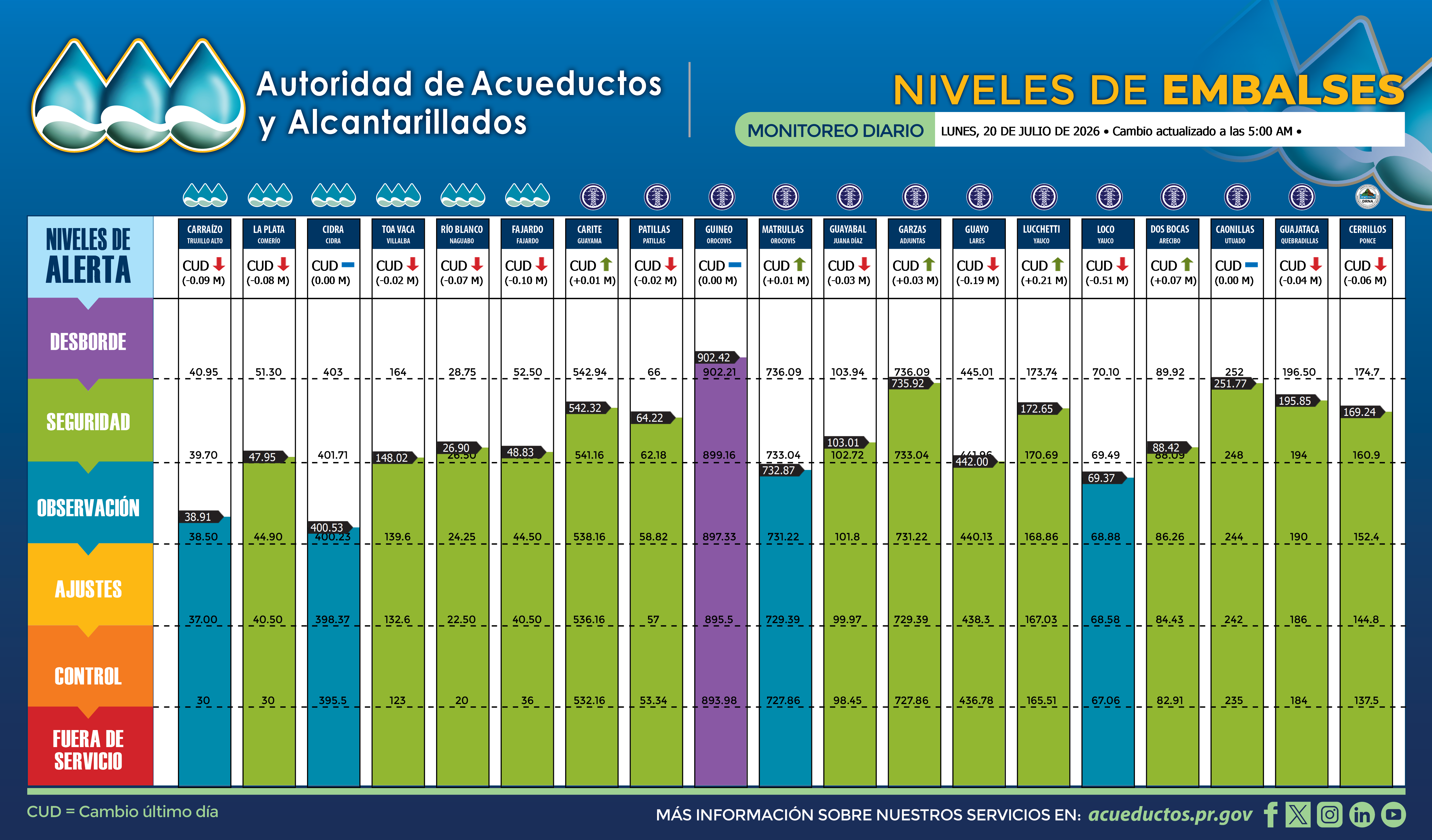
- Rivers and reservoirs are experiencing significant declines due to reduced recharge, with high temperatures and low moisture accelerating evaporation. Several reservoirs have already reached observational levels.
- Groundwater levels are falling across Puerto Rico and the U.S. Virgin Islands. Many wells in southern and southeastern Puerto Rico have reached operational adjustment or critical levels, as monitored by the U.S. Geological Survey.
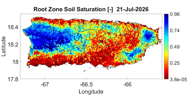
- According to the Puerto Rico Agricultural Water Management, root zone soil saturation is critically low across the southern and northern plains and the western interior, with only isolated pockets of moisture remaining from localized rainfall.
- Heightened fire danger has led to nearly 300 wildfire reports in this period, concentrated primarily across Puerto Rico’s southern and eastern municipalities.
Declining Streamflows Across Puerto Rico
Root Zone Soil Saturation Is Critically Low Across Much of Puerto Rico
Outlooks and Potential Impacts for Puerto Rico and the U.S. Virgin Islands
- Forecast models indicate a greater than 70% likelihood of below-normal precipitation and above-normal temperatures for Puerto Rico and the U.S. Virgin Islands from August through October 2026.
- The North American Multi-Model Ensemble (NMME) favors below-normal precipitation and above-normal temperatures over the next three months.
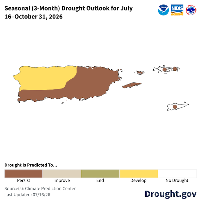
- A strengthening El Niño event is projected to reduce the frequency of tropical waves and cyclones. This will likely exacerbate precipitation deficits, leading to persistent or worsening drought conditions across the region, consistent with the latest NOAA Seasonal Drought Outlook.
Drought Is Expected to Persist or Develop through the Fall
Additional Resources
National Weather Service Weather Forecast Offices:
- San Juan Climate and Drought Information
- Puerto Rico and U.S. Virgin Islands Fire Weather Information
- Puerto Rico Drought Information Statement (July 17, 2026)
U.S. Drought Portal (Drought.gov):
USDA Caribbean Climate Hub:
- Archive of weekly Puerto Rico drought records developed by the Puerto Rico Scientific Drought Committee
- Drought and disaster assistance resources for tropical forestry and agriculture
- Caribbean Drought Learning Network
Southeast Regional Climate Center:
- Quarterly Climate Impact and Outlook Reports (June 2026), which includes Puerto Rico and U.S. Virgin Islands.
Prepared By
Emanuel Rodríguez-González
NOAA National Weather Service, San Juan Weather Forecast Office
Nora L. Álvarez-Berríos
International Institute of Tropical Forestry (IITF), USDA Forest Service
Christina Chanes
Virgin Islands Department of Planning & Natural Resources
Meredith Muth
NOAA National Integrated Drought Information System (NIDIS)
Héctor J. Jiménez
University of Puerto Rico Office of Climatology
William A. Gould
U.S. Department of Agriculture (USDA) Caribbean Climate Hub, USDA Forest Service Research and Development
Elliot Sosa
U.S. Geological Survey, Caribbean–Florida Water Science Center (CFWSC)
Brad Rippey
USDA Office of the Chief Economist
Puerto Rico Reporting Input: Special thanks to agronomists, extension agents, researchers, volunteers, ranchers, and farmers: Anayomari Torres, Luis Alexis Rodríguez Cruz, Manuel Matos, Jorge Alicea, Harry Ramírez, Rafael Silvestrini, Silmarie Crespo, Neftali Lluch, Dana López, Luz Jimenez, Mara Semidei, Zoelie Rivera, and Jose Tato Roig Francheschini.
USVI Reporting Input: Several individuals contributed to this report, and we acknowledge the following for their support: the farming community across the USVI, including VI Department of Planning and Natural Resources, Division of Fish and Wildlife, VI Department of Agriculture, as well as the USDA Office Chief Economist, National Parks Service in St. Croix and St. John, USDA Farm Service Agency, USDA Natural Resources Conservation Service in St. Croix, Coral Bay Community Council, and the many volunteer drought reporters, volunteers, and farmers from across the territory.
About This Report
This drought update is issued in partnership between the National Integrated Drought Information System (NIDIS), National Oceanic and Atmospheric Administration (NOAA) National Weather Service, the U.S. Department of Agriculture (USDA), and the University of the Virgin Islands. The purpose of the update is to communicate a potential area of concern for drought expansion and/or development within Puerto Rico and the U.S. Virgin Islands based on recent conditions and the upcoming three-month forecast. NIDIS is an interagency program within the Climate Program Office, which is part of NOAA's Office of Oceanic and Atmospheric Research.
NIDIS and its partners will issue these updates every two months. Subscribe for these U.S. Caribbean drought updates here.