Dry Conditions Persist In Western New York; New England and New York Anticipate Vibrant Fall Colors.
For more information, visit the Northeast DEWS Dashboard.
Key Points
- Moderate Drought (D1) and Abnormal Dryness(D0) lingering in western New York are supported by below to much-below streamflows in the 7-, 14-, and 28-day periods.
- Eastward expansion of additional dryness should be monitored in the next few weeks.
Current U.S. Drought Monitor map for the Northeast Drought Early Warning System (DEWS) with data valid for September 26, 2023.
The U.S. Drought Monitor depicts the location and intensity of drought across the country using 5 classifications: Abnormally Dry (D0), showing areas that may be going into or are coming out of drought, and four levels of drought (D1–D4).
U.S. Drought Monitor Categories
Abnormally Dry (D0)
Abnormally Dry (D0) indicates a region that is going into or coming out of drought. View typical impacts by state.
Moderate Drought (D1)
Moderate Drought (D1) is the first of four drought categories (D1–D4), according to the U.S. Drought Monitor. View typical impacts by state.
Severe Drought (D2)
Severe Drought (D2) is the second of four drought categories (D1–D4), according to the U.S. Drought Monitor. View typical impacts by state.
Extreme Drought (D3)
Extreme Drought (D3) is the third of four drought categories (D1–D4), according to the U.S. Drought Monitor. View typical impacts by state.
Exceptional Drought (D4)
Exceptional Drought (D4) is the most intense drought category, according to the U.S. Drought Monitor. View typical impacts by state.
Current U.S. Drought Monitor map for the Northeast Drought Early Warning System (DEWS) with data valid for September 26, 2023.
The U.S. Drought Monitor depicts the location and intensity of drought across the country using 5 classifications: Abnormally Dry (D0), showing areas that may be going into or are coming out of drought, and four levels of drought (D1–D4).
The U.S. Drought Monitor map is updated weekly on Thursday mornings, with data valid through the previous Tuesday at 7 a.m. Eastern.
Current Conditions
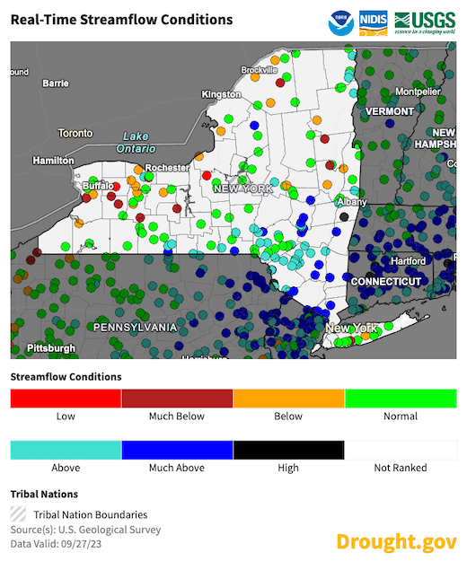
New York Streamflow Conditions
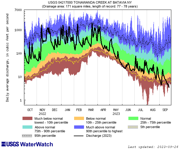
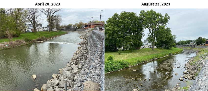
Streamflow Conditions: Tonawanda Creek in Western New York
The hydrograph below shows streamflow conditions at a USGS site on Tonawanda Creek in western New York. The period of record for this site is 78 years, and on a few days in late September the observed daily mean streamflow was the lowest for that day in history.
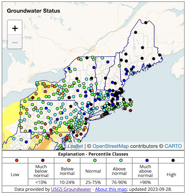
New England Groundwater Levels
Groundwater status in western New York supports the entrenched drought and hints at an eastward expansion of dryness.
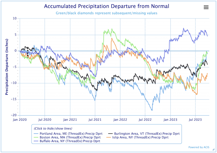
Accumulated Precipitation Departure from Normal: 2020–2023
State-Reported Conditions and Impacts
Connecticut
- Connecticut Drought Information Center
- Impacts:
- August 23, 2023: CT Post – Debate Over Fall Colors
Maine
- Maine Drought Task Force
- Impacts:
- September 24, 2023: News Center Maine – First Foliage Report
Massachusetts
- Massachusetts Drought Management Task Force
- Impacts:
- September 6, 2023: WCVB5 ABC Boston – Hints of Fall Already
- September 5, 2023: GBH – Longer Growing Season/New Fruits
- August 24, 2023: Vineyard Gazette – In The Wake of Maui Wildfires, Officials Plan for MV Changes
- August 22, 2023: Sentinel and Enterprise – Water Infrastructure Fixes for Drought and Flooding
New Hampshire
- New Hampshire Department of Environmental Services: Drought
- Impacts:
- September 23, 2023: Union Leader – Brighter Fall Colors Without Drought
- September 22, 2023: NHPR – When It Rained, It Poured: 2023 NH’s Wettest Summer Yet
- September 8, 2023: Monadnock Ledger Transcript – Weather Whiplash and the Hay Crop
New York
- New York State Department of Environmental Conservation (DEC): Drought
- Impacts:
- September 19, 2023: WAER – Ideal Summer Conditions for Trees Could Mean Good Fall Colors
- August 24, 2023: The Post-Journal – Study Requested on Climate Resilient Farming
- August 24, 2023: The East Hampton Star – How Gardens and Crops Were Challenged This Summer
Rhode Island
- Rhode Island Water Resources Board: Drought Management Program
- Impacts:
- August 24, 2023: The Jamestown Press – Summer Water Restrictions Lifted
Vermont
Find additional impacts through the National Drought Mitigation Center’s Drought Impact Reporter.
Visit the new Drought.gov state pages for additional maps and resources. Or, find local drought information by address, city or zip code on Drought.gov.
Outlooks
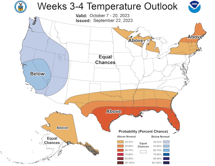
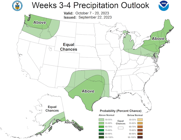
The Seasonal Drought Outlook indicates that drought removal is likely for western New York. The 3-4 week precipitation outlook supports this remediation, or at least a halt in the advancement of the dryness. The precipitation outlook shows western New York and northwestern Pennsylvania watersheds have above-normal chances for precipitation. However, the 3-4 week temperature Outlook, showing chances for above-normal temperatures in western New York, raises the potential for enough of a delay in fall cooling to maintain this area of drought.
Seasonal Drought Outlook: September 21–December 31
Week 3–4 Temperature and Precipitation Outlooks: October 7–20, 2023
For More Information
Featured News & Resources
- NIDIS Invests Approximately $2 Million to Build Tribal Drought Resilience
- 2023 National Soil Moisture Workshop: Recordings Now Available
- Dry Times Bi-Weekly Newsletter: Subscribe to the NIDIS national newsletter for drought news and events across the country. See what’s new from the September 21 edition. Starting October 18, Dry Times will be available every other week on Wednesdays.
- National Drought Mitigation Center September 2023 Newsletter: Featured in this edition: Drought Exercise Report Findings from our nation’s Capital.
- Climate.gov September 2023 El Niño-Southern Oscillation (ENSO) Blog
- Look Back on Some of the Environmental/Ecological Impacts of Last Winter – A Low Snow Winter: Northeast CASC scientists were interviewed by the Cape Cod Times.
The Commonwealth of Massachusetts Hosts State and Federal Partners to Discuss Drought
The Commonwealth of Massachusetts hosted a meeting of state and federal partners to discuss national, regional, and state drought resources at the USGS New England Water Science Center, in Northborough, MA. To enhance the existing drought monitoring network, Massachusetts is exploring opportunities to establish a statewide mesonet with in-situ soil moisture monitoring that aligns with remotely sensed satellite observations.The need for additional research and regional case studies on precipitation effectiveness—especially snow water equivalent (SWE)—was highlighted. The precipitation effectiveness data will help monitor rapid onset droughts and support the analysis of fire fuels in densely wooded areas of the state that are adjacent to highly populated areas.
The Massachusetts Department of Agriculture will soon release an economic impact report that will quantify specialty crop and animal feed losses associated with weather events during the 2023 calendar year, including the deep freeze in February; the hard frost in May; and the rainfall and flooding that impacted a large amount of vegetable crop, field crops, and hay and forage crops in July. Also, a recently released disaster recovery grant helped the agency develop a structure to capture impacts by crop for future events, including drought cycles.
Additional Resources
- Look back at previous Northeast DEWS Drought Status Updates
- Your local National Weather Service office
- NOAA Regional Climate Services Monthly Webinar Series (next webinar is on October 31)
- USDA Northeast Climate Hub
- USGS New England and New York Water Science Centers
Contacts for More Information
Sylvia Reeves
Regional Drought Information Coordinator (Northeast DEWS)
NOAA/CIRES/National Integrated Drought Information System (NIDIS)
Email: sylvia.reeves@noaa.gov
Ellen L. Mecray
Regional Climate Services Director, Eastern Region
NOAA/NESDIS/National Centers for Environmental Information
Email: Ellen.L.Mecray@noaa.gov
Prepared By
Sylvia Reeves
NOAA/National Integrated Drought Information System (NIDIS), CIRES
Samantha Borisoff, Jessica Spaccio, Keith Eggleston, Art DeGaetano, Natalie Umphlett
Northeast Regional Climate Center
Ellen Mecray
Regional Climate Services Director, Eastern Region, NOAA
Gardner Bent
USGS New England Water Science Center
In partnership with National Weather Service Offices of the Northeast and State Climate Offices of the Northeast.
This drought status update is issued in partnership between the National Oceanic and Atmospheric Administration (NOAA), U.S. Geological Survey, and the U.S. Department of Agriculture (USDA) to communicate concern for drought expansion and intensification within the Northeast U.S. based on recent conditions and the forecasts and outlooks. NIDIS and its partners will issue future drought status updates as conditions evolve.
