Drought Has Recently Expanded and Intensified and Is Expected to Persist.
This drought status update is based on information provided during the October 20, 2022 North Central U.S. Climate and Drought Outlook Webinar. View the webinar for more details.
Key Points
- Drought has rapidly intensified and expanded across the north central U.S. over the last month. Currently, 60% of the region is in moderate to exceptional drought (D1–D4) according to the U.S. Drought Monitor, with 30% in severe drought or worse (D2–D4). Exceptional drought (D4) is affecting 30% of Kansas and 12% of Nebraska, as well as small portions of Colorado, Missouri, and South Dakota.
- While the recent rapid intensification of drought has been most prominent across the Midwest, drought has been persistent and more severe across the Missouri River Basin/Great Plains. Some areas within the Missouri River Basin are entering their second or third year of drought.
- Impacts from the drought have also recently intensified. Most notably, below-normal streamflow is a major issue, including record low levels on the Mississippi, Missouri, and Ohio rivers. River navigation and transportation of goods has been greatly inhibited and restricted. Industry sources estimate that the current volume of goods on the waterway is effectively 45% lower than usual since ships and barges cannot carry as much in low water.
- Other major impacts include extremely dry soils for winter crops and a lack of fall soil moisture recharge, very poor pasture and rangeland conditions, fires, and limited surface and groundwater for municipal and individual water supply and livestock.
- While there is a chance for some precipitation relief in late October into early November, the current drought situation will require multiple rounds of significant precipitation in order to see significant recovery.
- Fall is a very important season for replenishing soil moisture in order to secure moisture that is needed for the upcoming growing season. If fall moisture is not replenished, the risk for drought continuing is increased for the next growing season, as improvements to soil moisture are limited over the winter, particularly in northern areas where soils are mostly frozen.
- A potential issue this winter could be that dry soils and cold temperatures lead to deeper frost depths, which could cause issues with buried infrastructure and pipelines (e.g., water main breaks and the potential for frozen water lines).
Current U.S. Drought Monitor map for the north central U.S. with data valid for October 18, 2022. The U.S. Drought Monitor (USDM) is updated each Thursday to show the location and intensity of drought across the country. Drought categories show experts’ assessments of conditions related to dryness and drought including observations of how much water is available in streams, lakes, and soils compared to usual for the same time of year.
U.S. Drought Monitor Categories
Abnormally Dry (D0)
Abnormally Dry (D0) indicates a region that is going into or coming out of drought. View typical impacts by state.
Moderate Drought (D1)
Moderate Drought (D1) is the first of four drought categories (D1–D4), according to the U.S. Drought Monitor. View typical impacts by state.
Severe Drought (D2)
Severe Drought (D2) is the second of four drought categories (D1–D4), according to the U.S. Drought Monitor. View typical impacts by state.
Extreme Drought (D3)
Extreme Drought (D3) is the third of four drought categories (D1–D4), according to the U.S. Drought Monitor. View typical impacts by state.
Exceptional Drought (D4)
Exceptional Drought (D4) is the most intense drought category, according to the U.S. Drought Monitor. View typical impacts by state.
Current U.S. Drought Monitor map for the north central U.S. with data valid for October 18, 2022. The U.S. Drought Monitor (USDM) is updated each Thursday to show the location and intensity of drought across the country. Drought categories show experts’ assessments of conditions related to dryness and drought including observations of how much water is available in streams, lakes, and soils compared to usual for the same time of year.
Current Conditions and Impacts
Current Conditions
- Drought has rapidly intensified and expanded across the north central U.S. over the last month. Currently, 60% of the region is in moderate to exceptional drought (D1–D4) according to the U.S. Drought Monitor, with 30% in severe drought or worse (D2–D4). 86% of the region is considered abnormally dry (D0).
- Over the last four weeks, many areas, particularly across the Midwest, have worsened by at least one drought category on the U.S. Drought Monitor and in some areas by two to three categories (Figure 1). Drought has intensified most rapidly across southern Missouri, Kentucky, southern Illinois, southern Indiana, and northern Iowa.
- While the recent rapid intensification of drought has been most prominent across the Midwest, severe drought has persisted for up to two years across portions of the Missouri River Basin/Great Plains. The worst level of drought, exceptional drought (D4), is most extensive across Kansas and Nebraska (30% and 12% respectively), but is also impacting small portions of Colorado, Missouri, and South Dakota. Impacts from the drought have accelerated recently (see Impacts section below), some due to the underlying long-term dryness.
- The rapid intensification of drought has primarily been driven by a lack of precipitation over the last 30 days, with a majority of the north central U.S. only receiving 5%–50% of normal precipitation. Portions of the Plains and the Ohio River Basin have received less than 5% of normal precipitation (Figure 2). Only a few areas have received above-normal precipitation, including portions of Colorado, Montana, and Wyoming, as well as portions of Michigan.
- Temperatures over the last 30 days have been near to below normal across much of the north central U.S. (Figure 3). Some areas in the far east have been 4 to 6 degrees below normal. Moving further west, much of the western Missouri River Basin has had above-normal temperatures.
Figure 1. 4-Week Change Map for the U.S. Drought Monitor
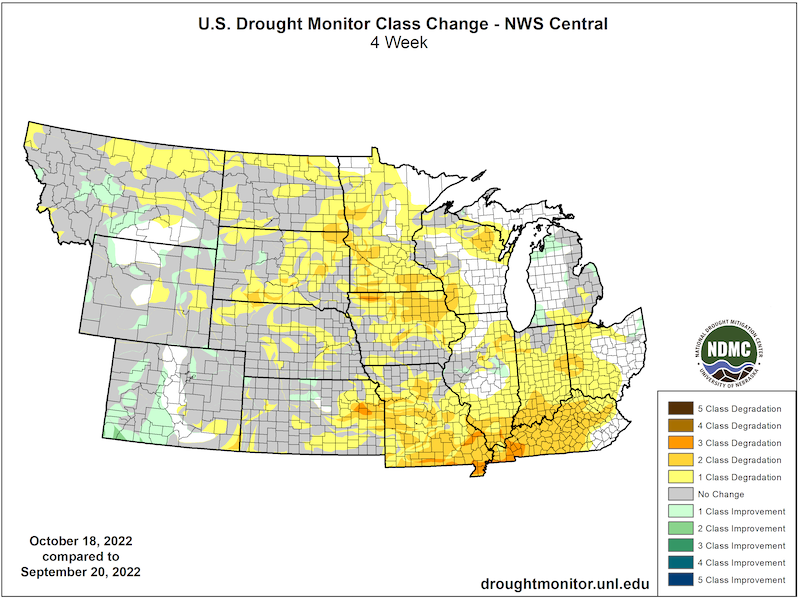
Figure 2. 30-Day Percent of Normal Precipitation (September 24–October 23, 2022)
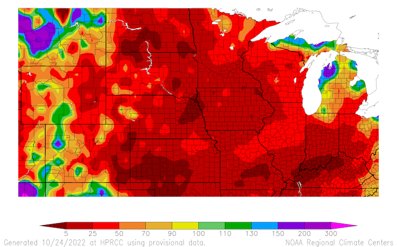
Figure 3. 30-Day Departure from Normal Temperature (°F) (September 24–October 23, 2022)

Drought Impacts
- Below-normal streamflow is one of the most critical impacts the drought is currently having on the region (Figure 4), including record low levels on major U.S. riverway systems for navigation—the Mississippi, Missouri, and Ohio rivers (Figure 5). Low water records from significant droughts in the past (1988, 2000, and 2012) have recently been broken.
- River levels are typically lower in the fall, but this year they are even lower than normal, which is causing significant issues as fall harvest is well underway and over 60% of all grain shipped in the U.S. moves through New Orleans, LA off the Mississippi River. When river levels are below normal, ships and barges are not able to transport as much due to the risk of grounding or dragging on the bottom of the river. Industry sources estimate that the current volume of goods on the waterway is effectively 45% lower than usual since ships and barges cannot carry as much in low water.
- The newly-established river cruise industry on the Mississippi River is having to make adjustments to their cruises based on the low water levels. Cruises have had to be rerouted to different cities/ports, companies are having to offer free cancellations or future cruise credits, and in some cases, the cruises have been canceled.
- As drought conditions continue to impact the Missouri River Basin, total system storage is much below average. As a result, the U.S. Army Corps of Engineers are adjusting the release of water at Gavins Point to meet the current service level.
- While there aren’t too many reports of municipal water supply issues, some communities are making adjustments to their water supply source as a result of limited water. Cairo, Illinois has temporarily switched from Mississippi River water to their alternative groundwater source. There are also reports of wells drying in areas like Iowa and Nebraska.
- Surface water is limited in many areas as well, including stock ponds across pastures and rangeland, in addition to low lake levels, which are impacting fish and wildlife. Lake Minnetonka near Minneapolis-St. Paul, Minnesota is at its lowest in 30 years. Minnehaha Falls, a well-known landmark in the Twin Cities, is dry.
- As expected, soil moisture values reflect the extremely dry conditions across the north central U.S., particularly in the Midwest states (Figure 6). Fall is a very important season for replenishing soil moisture for the next growing season. If fall moisture is not replenished, the risk for drought continuing is increased for the next growing season, as improvements to soil moisture are limited over the winter, particularly to the north where soils are mostly frozen. Southern and eastern portions of the region might be able to see more recovery over winter with warmer soils.
- The dry conditions this fall have aided harvest, as farmers have had many days in a row suitable for field work. However, the drying has happened almost too quickly in some areas and has led to issues like shattering of soybeans and increased fire risk and occurrence.
- Winter wheat is being planted in very dry soils across states like Kansas and Indiana, which is limiting the emergence of the crop. While winter wheat does not need much moisture to establish itself in order to survive the winter, it does need some moisture, and areas that have planted winter wheat currently need rain.
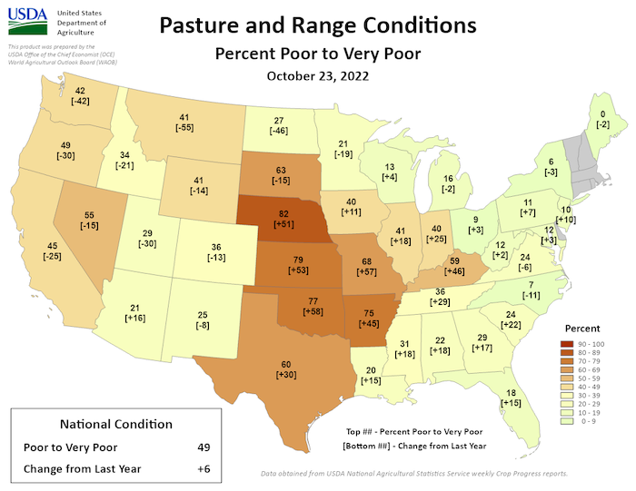
- Across the Great Plains, pasture and rangeland is reported to be in poor to very poor condition. 82% is rated as poor to very poor in Nebraska, 79% in Kansas, 68% in Missouri, and 63% in South Dakota (Figure 7).
- Fire risk has been and continues to be high this fall. There have been many fires resulting from harvest activities (e.g., combine fires) and dry vegetation. Burn bans are in effect across many counties in several states.
Report your drought impacts through the Condition Monitoring Observer Reports (CMOR):
Figure 4. USGS 28-Day Average Streamflow for October 23, 2022 (Compared to Historical Record)
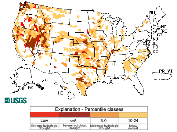
Figure 5. Map of Record Low 7-Day Streamflow – Valid on October 23, 2022
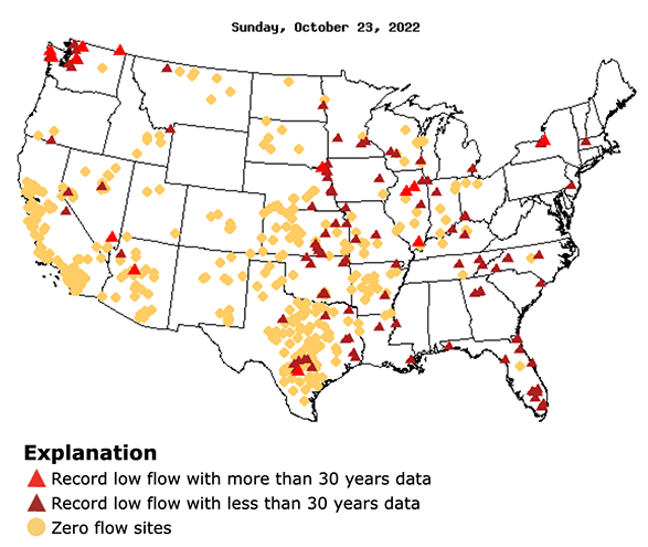
Figure 6. Topsoil Moisture (Percent Rated Short to Very Short) – Week ending October 23, 2022
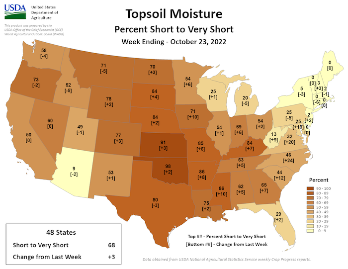
Figure 7. Pasture and Range Conditions (Rated Poor to Very Poor) – As of October 23, 2022
Outlook and Potential Impacts
- Based on the precipitation forecast for the next week (October 25–November 1), it is possible that portions of the Midwest, including Missouri, might see some precipitation (Figure 8).
- This possibility for some short-term relief continues through November 7, where the 8–14 day outlook shows the possibility for above-normal precipitation across much of the Midwest and into the Missouri River Basin (Figure 9). Short-term precipitation relief will be beneficial for some river level recovery from record lows for navigation, and cover crops and winter wheat to establish growth before the winter.
- However, when looking at the entire month of November, much of the southern portion of the central U.S. (Iowa, Kansas, Nebraska, Missouri, Illinois) has greater chances for below-normal precipitation. Areas to the north have equal chances for above-, near-, or below-normal precipitation for November (Figure 10).
- Above-normal temperatures are more likely in November across the Central Plains into Missouri and South Dakota, while other areas have equal chances for above-, near-, or below-normal November temperatures (Figure 11).
- The potential for above-normal temperatures and below-normal precipitation has elevated the risk for wildland fire across portions of the Plains, Iowa, and Missouri (Figure 12). Fire will continue to be a risk for the dry areas of the north central U.S. throughout the fall.
- Without substantial precipitation in November, it is unlikely that river levels will return to normal for this time of year in the near future, leading to continued issues with navigation along major navigational rivers like the Mississippi River.
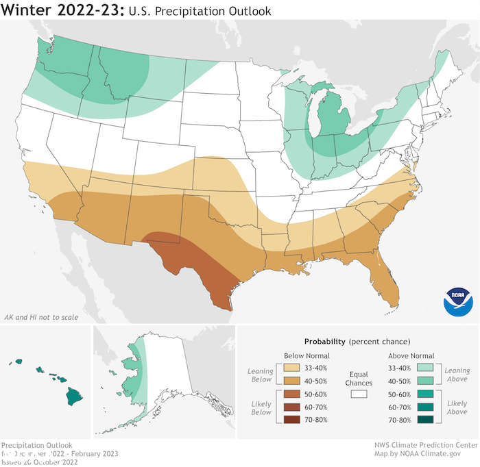
- NOAA recently issued the winter outlook for December 2022 to February 2023. In the north central U.S., there is a greater chance for below-normal precipitation to continue across extreme southern portions of the region (Kansas), equal chances for above-, near-, or below-normal precipitation across much of the region, with the possibility for above-normal precipitation across the Great Lakes region (Figure 13).
- While winter could bring some more precipitation to the region, it is unlikely there will be substantial improvements to drought as this is a difficult time of the year to establish soil moisture due to frozen grounds, particularly in the north.
- Another potential issue this winter could be that dry soils and cold temperatures lead to deeper frost depths, which could cause issues with buried infrastructure and pipelines (e.g., water main breaks and the potential for frozen water lines).
Figure 8. Quantitative Precipitation Forecast for the next 7 days (October 25–November 1, 2022)
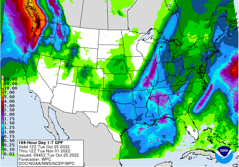
Figure 9. 8–14 Day Precipitation Outlook (Valid November 1–7, 2022)
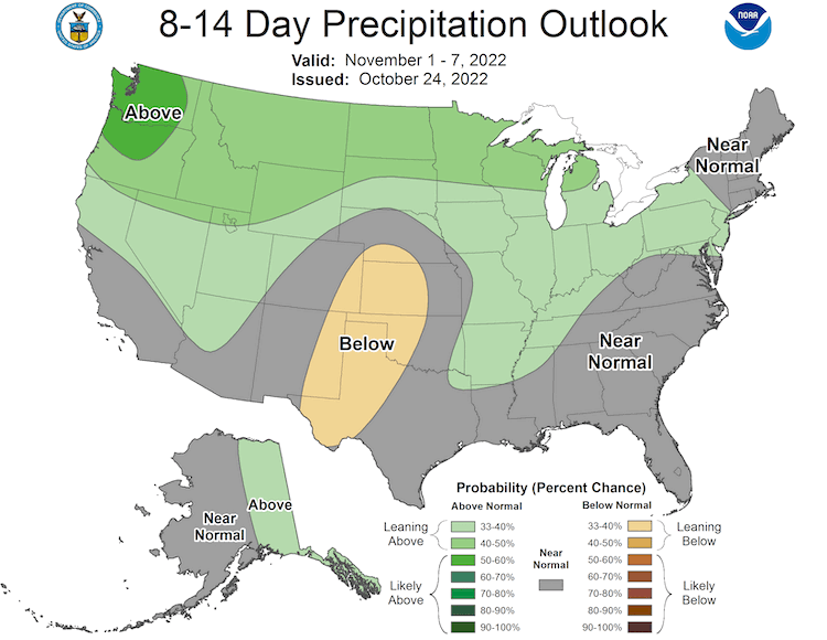
Figure 10. Monthly Precipitation Outlook for November 2022
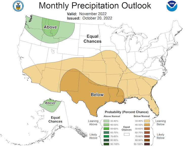
Figure 11. Monthly Temperature Outlook for November 2022
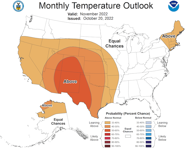
Figure 12. Significant Wildland Fire Potential Outlook for October 2022
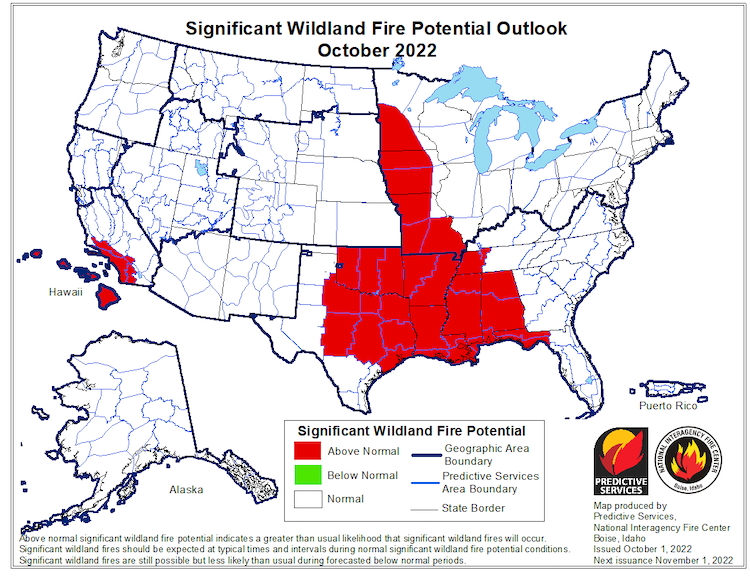
Figure 13. Winter Precipitation Outlook (December 2022–February 2023)
For More Information
- NIDIS and its partners will issue future updates as conditions evolve.
- A special thank you to the state climate offices in the Midwest and Missouri River Basin for providing local information on drought conditions and impacts included in the webinar and on this report.
- This drought status update is based on information provided during the October 20, 2022 North Central U.S. Climate and Drought Outlook webinar. View the webinar for more details
- The next North Central U.S. Climate and Drought Summary & Outlook Webinar will take place on November 17, 2022, and will offer updated information about conditions, impacts, and outlooks.
- More local information is available from the following resources:
- To report or view local drought impact information:
- Report your drought impacts through Condition Monitoring Observer Reports (CMOR)
- View CoCoRaHS Condition Monitoring reports.
Prepared By
Molly Woloszyn
NOAA/National Integrated Drought Information System (NIDIS), CIRES/University of Colorado Boulder
Laura Edwards
South Dakota State University Extension
Brad Rippey
USDA Office of the Chief Economist
Doug Kluck
NOAA/National Centers for Environmental Information
Dennis Todey
USDA Midwest Climate Hub
This drought status update is issued in partnership between the National Oceanic and Atmospheric Administration (NOAA) and the U.S. Department of Agriculture (USDA) to communicate a potential area of concern for drought expansion and/or development within the Midwest U.S. based on recent conditions and the upcoming forecast. NIDIS and its partners will issue future drought status updates as conditions evolve.


