Drought Persists Across Missouri River Basin, Likely to Continue
Key Points
- Drought is currently affecting just over 46% of the Missouri River Basin, with 74% of the Basin abnormally dry (D0), according to the U.S. Drought Monitor. Exceptional drought (D4)—the worst level of drought—was introduced in early August in southwestern Nebraska, with portions extending into northwest Kansas and northeast Wyoming.
- Many of the current known impacts from drought are on agriculture, including crops (corn, soybeans, sorghum, alfalfa hay, pulse crops) as well as livestock due to poor pasture and rangeland conditions, limited forage and surface water. In addition, wildland fire has been an issue in Montana, Wyoming, and Nebraska; grasshoppers have damaged vegetation in Montana and the Dakotas; and low flows and high temperatures have resulted in fishing closures in Montana.
- The monthly temperature and precipitation outlooks for September 2022 show an increased chance for the continuation of above-normal temperatures and below-normal precipitation across much of the Basin, which likely means the persistence of drought conditions.
- Potential issues of persistent drought conditions moving into the fall season include limited moisture for cover crops and winter wheat, which are difficult to establish in dry conditions. In addition, persistent drought could increase hydrological impacts to surface and groundwater, as well as ecological impacts.
Current U.S. Drought Monitor map for the Missouri River Basin Drought Early Warning System (DEWS) region with data valid for August 30, 2022. The U.S. Drought Monitor (USDM) is updated each Thursday to show the location and intensity of drought across the country. Drought categories show experts’ assessments of conditions related to dryness and drought including observations of how much water is available in streams, lakes, and soils compared to usual for the same time of year.
U.S. Drought Monitor Categories
Current U.S. Drought Monitor map for the Missouri River Basin Drought Early Warning System (DEWS) region with data valid for August 30, 2022. The U.S. Drought Monitor (USDM) is updated each Thursday to show the location and intensity of drought across the country. Drought categories show experts’ assessments of conditions related to dryness and drought including observations of how much water is available in streams, lakes, and soils compared to usual for the same time of year.
Current Conditions
- Drought is currently affecting just over 46% of the Missouri River Basin, with 74% of the Basin abnormally dry (D0), according to the U.S. Drought Monitor.
- Drought has remained relatively the same or improved in some areas over the last four weeks; however, there have been some pockets of drought intensification across Nebraska, Montana, Kansas, and South Dakota (Figure 1).
- Exceptional drought (D4)—the worst level of drought—was introduced in early August in southwestern Nebraska, with portions extending into northwestern Kansas and northeastern Wyoming.
- Below-normal precipitation, along with slightly above-normal temperatures, have been driving the drought persistence and intensification.
- Precipitation has been only 5%–25% of normal across most of Nebraska and Kansas, as well as northeastern Montana, western North Dakota, portions of South Dakota, and northeastern Colorado (Figure 2).
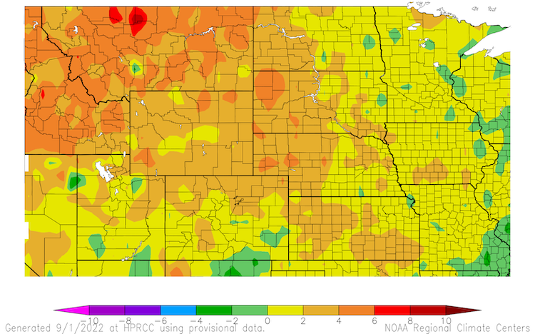
- Temperature departures were highest in the Upper Basin, with temperatures 2–6°F above normal across the majority of Montana, Wyoming, and western portions of North Dakota, South Dakota, and Nebraska (Figure 3).
Figure 1. 4-Week U.S. Drought Monitor Change Map (Since August 2, 2022)
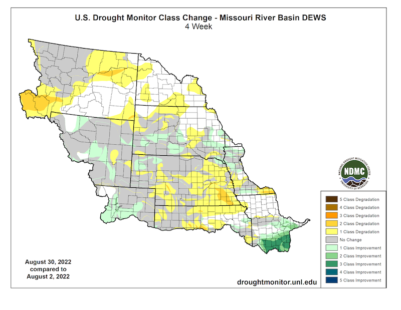
Figure 2. 30-Day Percent of Normal Precipitation (August 2–30, 2022)
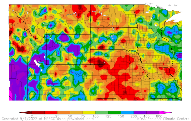
Figure 3. 30-Day Departure from Normal Temperature (°F) (August 2–30, 2022)
Impacts
- Many of the current known impacts from drought are on agriculture, including crops as well as livestock due to poor pasture and rangeland conditions, limited forage and surface water. In addition, wildland fire has been an issue in Montana, Wyoming, and Nebraska; grasshoppers have damaged vegetation in Montana and the Dakotas; and low flows and high temperatures have resulted in fishing closures in Montana.
- Soil moisture is significantly below normal across much of Nebraska and northern Kansas, as well as portions of Iowa, South Dakota, North Dakota, and Wyoming (Figure 4).
- 78% of pasture and rangeland in Nebraska is reported to be in poor to very poor condition, according to the U.S. Department of Agriculture (Figure 5). Kansas and South Dakota also report over 50% of their pasture and rangeland in poor to very poor condition.
- Reduced forage production due to drought has producers continuing to sell livestock, and producers are trying to find alternate sources of feed for livestock since hay is in short supply.
- Yield and the quality of crops is reduced as a result of the poorly timed hot and dry conditions this summer. Corn, soybeans, sorghum, wheat, and alfalfa hay were particularly hit hard across Nebraska, Iowa, Kansas, Montana, and portions of South Dakota. Some corn fields are being cut for silage as a result of drought damage.
- This summer’s heat and drought have really taken a toll on sorghum production, which is typically a drought-resilient crop. According to the USDA, this year’s projected U.S. sorghum yield is down 23% from last year, while the production forecast is down 36% from 2021.
- In Montana, low flows and high temperatures have resulted in fishing closures in southwest Montana. In addition, pulse crop (e.g., lentils, dry beans, chickpeas) production in the state has faced persistent extreme to exceptional drought this summer (D3–D4).
- Wildland fire has been an issue in Montana, Wyoming, and Nebraska. The Deep Draw Fire burned 827 acres in southern Montana in mid-August.
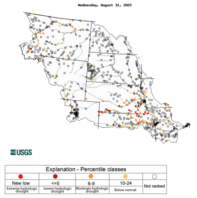
- On the hydrology side, streamflow is below normal across areas in drought in the Basin, particularly southwestern Nebraska and northern Kansas (Figure 6). Due to reduced water supply in Kansas, irrigation is becoming very expensive, and in some cases, irrigation water was turned off altogether. Surface water sources for livestock are also very low across areas of Montana, Nebraska, and Kansas.
- The dry conditions last year and this year have increased the grasshopper population across Montana, North Dakota, and South Dakota. An overabundance of grasshoppers can greatly damage vegetation.
Report your drought impacts through the Condition Monitoring Observer Reports (CMOR):
Figure 4. NASA SPoRT-LIS 0–100 cm Soil Moisture Percentiles (Valid September 1, 2022)
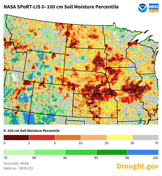
Figure 5. Pasture and Range Conditions (Rated Poor to Very Poor) – As of August 28, 2022
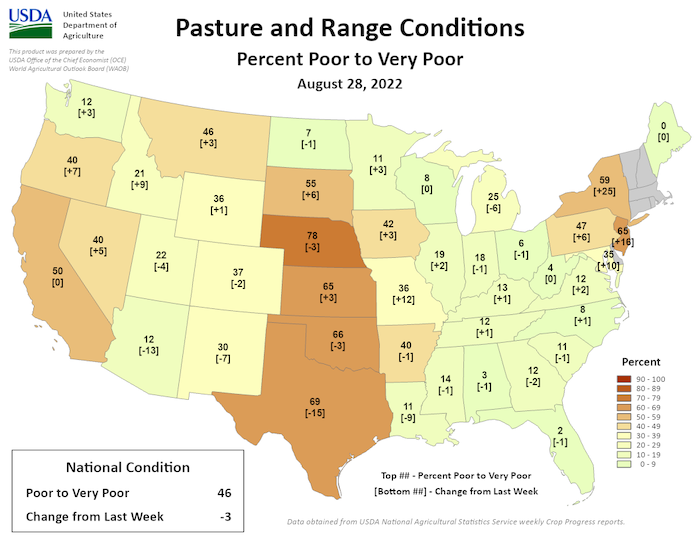
Figure 6. 7-Day Average Streamflow Compared to Historical Streamflow (Valid on August 31, 2022)
Outlook and Potential Impacts
- Short-term outlooks for September 9–15 show increased chances for above-normal temperatures across the Basin, with the exception of central Montana. The Climate Prediction Center's precipitation outlook for September 9–15 shows greater chances for above-normal precipitation across the lower Basin, and below-normal precipitation in the eastern Dakotas into Minnesota (Figure 7).
- The monthly temperature and precipitation outlooks for September 2022 (Figures 8 and 9) show an increased chance for the continuation of above-normal temperatures and below-normal precipitation across a majority of the Basin, which likely means the persistence of drought conditions.
- Potential issues of persistent drought conditions moving into the fall season include limited moisture for cover crops and winter wheat, which are difficult to establish in dry conditions.
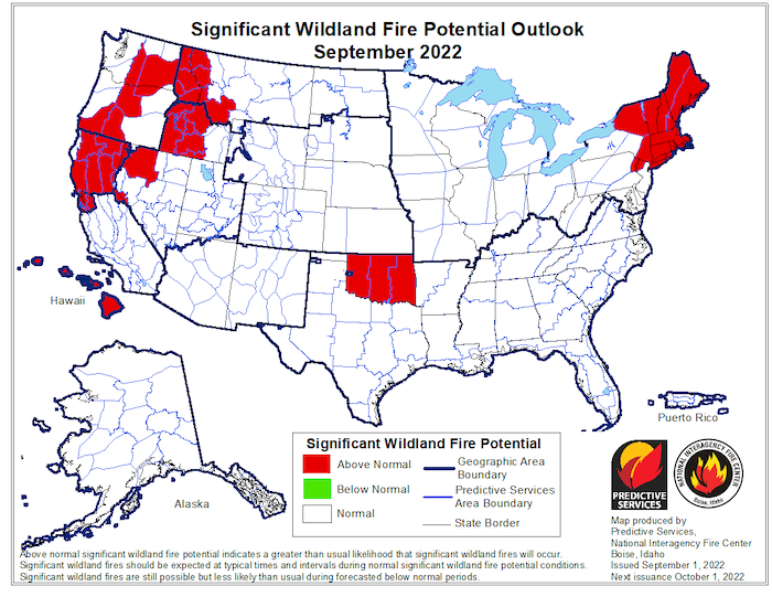
- Despite the potential for the persistence of drought, significant wildland fire potential is not elevated, and is expected to be normal for this time of year across the Basin this September (Figure 10).
- Hydrological impacts could increase if drought continues—meaning that soil moisture and surface water, streamflow, and groundwater levels could decline. Ecological impacts could also increase with reduced availability of water overall.
Figure 7. 8–14 day Precipitation Outlook (Valid September 9–15, 2022)
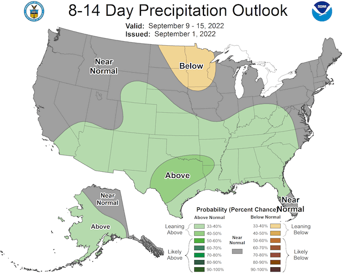
Figure 8. Monthly Precipitation Outlook for September 2022
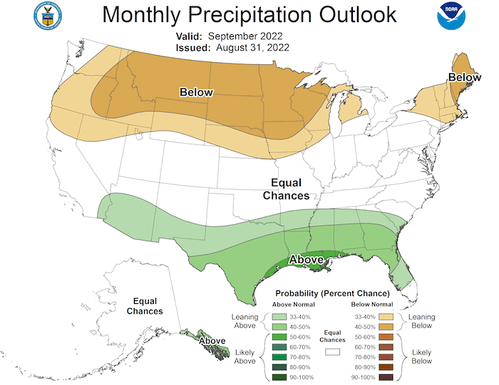
Figure 9. Monthly Temperature Outlook for September 2022
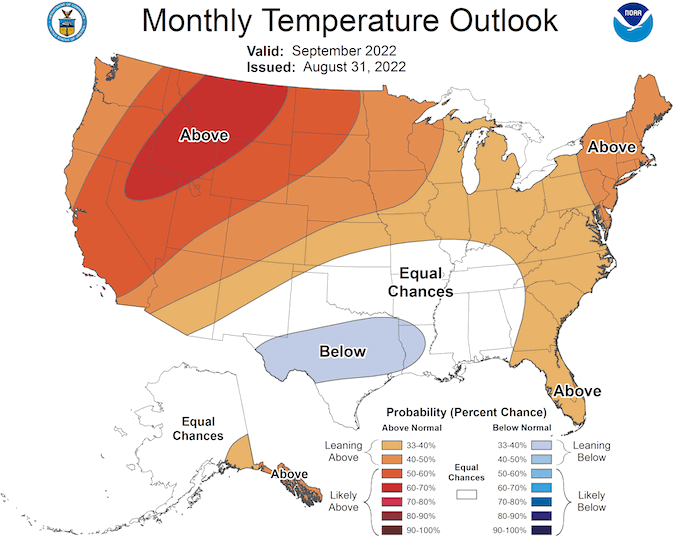
Figure 10. Significant Wildland Fire Potential Outlook for September 2022
For More Information
- NIDIS and its partners will issue future updates as conditions evolve.
- A special thank you to the state climate offices in the Missouri River Basin for providing local information on drought conditions and impacts included in the webinar and on this report.
- More local information is available from the following resources:
- To report or view local drought impact information:
- Report your drought impacts through Condition Monitoring Observer Reports (CMOR).
- To view or submit reports in Montana, visit the Montana Drought Impact Reporter.
- View CoCoRaHS Condition Monitoring reports.
- The upcoming North Central U.S. Climate and Drought Summary & Outlook Webinar on September 15, 2022 will offer updated information about conditions, impacts, and outlooks.
Prepared By
Molly Woloszyn
NOAA/National Integrated Drought Information System (NIDIS), CIRES/CU Boulder
Doug Kluck
NOAA/National Centers for Environmental Information
Dannele Peck & Dennis Todey
USDA Northern Plains Climate Hub & Midwest Climate Hub
Kevin Low
NOAA/National Weather Service Missouri Basin River Forecast Center
Audra Bruschi & Ray Wolf
NOAA/National Weather Service Central Region
Rezaul Mahmood & Gannon Rush
High Plains Regional Climate Center
This drought status update is issued in partnership between the National Oceanic and Atmospheric Administration (NOAA) and the U.S. Department of Agriculture (USDA) to communicate a potential area of concern for drought expansion and/or development within the Missouri River Basin based on recent conditions and the upcoming forecast. NIDIS and its partners will issue future drought status updates as conditions evolve.


