Floods in Central Texas; Dry Pattern Emerging in East-Central Kansas, Western Oklahoma, and the Gulf Coast
Key Points
- While significant rainfall improved conditions this week, Moderate to Severe Drought (D1-D2) continues across northern Kansas. Southern Kansas has seen recent improvements.
- Oklahoma has been drought-free since June 3, according to the U.S. Drought Monitor.
- Exceptional Drought (D4) persists along the Rio Grande and parts of the Edwards Plateau region of Texas.
- In spite of the devastating and historic floods over the Texas Hill Country, long-term hydrological drought conditions continue in much of the region.
- After the flash floods on July 4–5, local reservoirs saw large increases, but this was not enough to alleviate water supply issues. Local reservoir levels remain low as long-term drought persists across parts of the region.
- The Edwards Aquifer remains within Stage 3 drought levels.
- A heat wave is expected to develop in eastern parts of the Southern Plains. Going into next week, NOAA’s National Weather Service (NWS) predicts a risk of hazardous heat for most of Kansas, central/eastern Oklahoma, and northeastern Texas. Many Oklahoma and eastern Texas counties are already under a heat advisory.
- Seasonal outlooks favor drought persistence and expansion, and high summer temperatures may mean recent improvements are short-lived.
This update is based on data available as of Thursday, July 24, 2025 at 9 a.m. CT. We acknowledge that conditions are evolving.
Precipitation for the last 30 days (June 22–July 21, 2025), compared to historical conditions from 1991–2020. Precipitation is shown as a percentage of normal conditions for these dates. Brown hues indicate below-normal precipitation, and blue/green hues indicate above-normal precipitation.
Drought is defined as the lack of precipitation over an extended period of time, usually for a season or more, that results in a water shortage. Changes in precipitation can substantially disrupt crops and livestock, influence the frequency and intensity of severe weather events, and affect the quality and quantity of water available for municipal and industrial use.
Learn MorePrecipitation Shown as a Percentage of Normal Conditions
<25% of Normal
Precipitation was only 0% to 25% of the historical average for this location, compared to the same date range from 1991–2020.
25%–50% of Normal
Precipitation was 25% to 50% of the historical average for this location, compared to the same date range from 1991–2020.
50%–75% of Normal
Precipitation was 50% to 75% of the historical average for this location, compared to the same date range from 1991–2020.
75%–100% of Normal
Precipitation was 75% to 100% of the historical average for this location, compared to the same date range from 1991–2020.
100%–150% of Normal
Precipitation was 100% to 150% of the historical average for this location, compared to the same date range from 1991–2020.
150%–200% of Normal
Precipitation was 150% to 200% of the historical average for this location, compared to the same date range from 1991–2020.
200%–300% of Normal
Precipitation was 200% to 300% of the historical average for this location, compared to the same date range from 1991–2020.
>300% of Normal
Precipitation was greater than 300% of the historical average for this location, compared to the same date range from 1991–2020.
Precipitation for the last 30 days (June 22–July 21, 2025), compared to historical conditions from 1991–2020. Precipitation is shown as a percentage of normal conditions for these dates. Brown hues indicate below-normal precipitation, and blue/green hues indicate above-normal precipitation.
Precipitation data are updated daily, with a delay of 3 to 4 days to allow for data collection and quality control.
Drought is defined as the lack of precipitation over an extended period of time, usually for a season or more, that results in a water shortage. Changes in precipitation can substantially disrupt crops and livestock, influence the frequency and intensity of severe weather events, and affect the quality and quantity of water available for municipal and industrial use.
Learn MoreCurrent Conditions and Impacts for the Southern Plains
- Significant rainfall this week helped reduce drought and dryness in northeastern Kansas. However, Moderate to Severe Drought (D1-D2) remains in northern parts of the state, with a recent expansion of Abnormally Dry (D0) conditions over eastern Kansas. Kansas Governor Laura Kelly updated drought declarations to include northern counties.
- Southern Kansas has seen drought improvement:
- The region has experienced ample precipitation over the past two months. Sedgwick County recorded its wettest June on record, averaging just over 11 inches of rainfall.
- Cheney Lake, which provides water for Wichita, has returned to near normal levels—96.87% of capacity as of July 16, 2025.
- Despite the recent precipitation and reservoir rise, the City of Wichita remains in Stage 2 drought status based on the 12-month average at Cheney Lake.
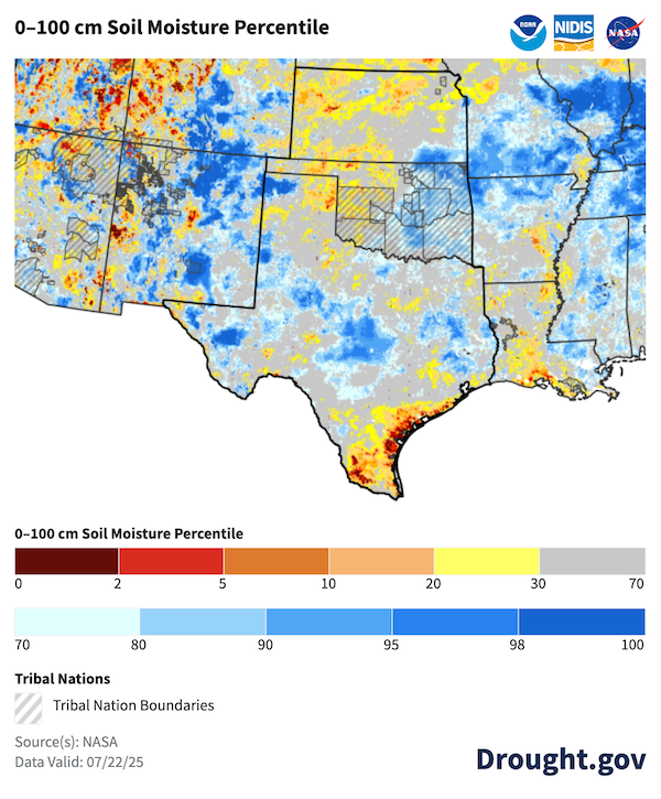
- Western Oklahoma and the Texas Panhandle have experienced below-average precipitation over the last 30 days. This, along with high summer temperatures, has led to reduced soil moisture in these regions.
- The Coastal Bend region of Texas, near Corpus Christi, has seen below-average precipitation for the past 40 days, a drying pattern which is also reflected in upper-layer (1-meter) soil moisture values.
- Exceptional Drought (D4) contracted to a smaller area over the southern Edwards Plateau and the Big Bend region, according to the U.S. Drought Monitor.
- Parts of the Texas Hill Country have been in Severe to Exceptional Drought (D2-D4) since January 2022, but precipitation during spring 2025 had been near normal.
- The region experienced historic flooding on July 4-5, 2025, tragically devastating the region and leading to the loss of lives.
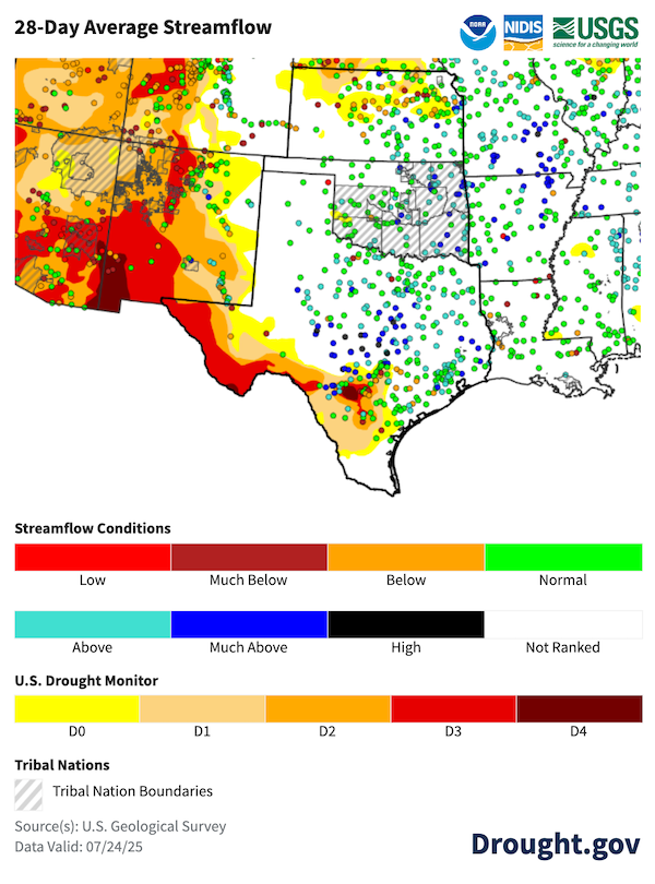
- Despite the recent flooding, long-term hydrologic drought impacts remain. Local reservoirs saw increases of 2.5% (Medina Lake), ~1% (Twin Buttes Reservoir), and 18% (Canyon Lake). In the two days from July 4–6 alone, Canyon Lake reservoir levels rose 11 vertical feet, which is its largest two-day rise on record at that reservoir. However, reservoir conditions were so low that even with these large increases, Canyon Lake is only 68% full, Medina Lake is 6.3% full, and Twin Buttes Reservoir is 16.1% full.
- Edwards Aquifer groundwater levels also saw an increase, but remain below Stage 3 drought levels.
Developing Dryness in Northern Kansas and Southern Texas
Streamflow Improved, But Problems Persist in Southern Texas and Northern Kansas
Outlooks and Potential Impacts in the Southern Plains
- The NWS Climate Prediction Center’s 6-10 and 8-14 day outlooks favor above-normal temperatures for Oklahoma and Texas with mostly near-normal temperatures for Kansas. Outlooks show mostly near-normal to above-normal precipitation chances through August 6, 2025.
- A heat wave is expected to develop in eastern parts of the Southern Plains. According to NOAA’s National Weather Service, most of Kansas, central/eastern Oklahoma, and northeastern Texas are at risk for hazardous heat from July 26–30. From July 31-August 1, NWS predicts a slight risk of extreme heat for most of Texas into southern Oklahoma. Many counties across Oklahoma and eastern Texas are already under a heat advisory.
- No clear climate signal is driving August climate outlooks, and there is an equal chance of above- or below-normal precipitation for the Southern Plains
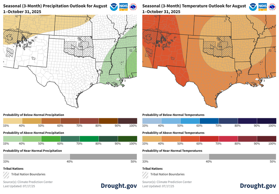
- The Climate Prediction Center’s temperature outlooks show a high likelihood of above-normal temperatures for August–October. The extensive rainfall in Texas in early July has reduced the chances for excessively high temperatures in areas where the rain fell during the rest of the summer.
- Precipitation outlooks show an equal chance of above-, near-, or below-normal precipitation for most of the Southern Plains for the month and season ahead. The August–October precipitation outlook shows weak odds slightly favoring below-normal precipitation for northwestern Kansas.
- The El Niño–Southern Oscillation (ENSO) is currently neutral.
- Forecast models show ENSO-neutral will likely persist through summer. There is a chance that La Niña will develop in fall and winter 2025.
- ENSO-neutral means neither El Niño nor La Niña is driving current weather patterns for the Southern Plains, and we lean more heavily on other climate patterns when making seasonal forecasts.
- The Pacific Decadal Oscillation (PDO) is still below -1.
- A negative PDO has similar impacts on Southern Plains weather patterns as La Niña. When the two occur together, they amplify each other’s impacts. In the summer months, a negative PDO can shift rainfall eastward and push summer temperatures higher in the Southern Plains.
- The PDO has been negative since January 2020 and reached a new minimum of -3.8 in October 2024, the lowest value in modern history.
- Seasonal outlooks and global climate patterns favor drought persistence and expansion—high summer temperatures may mean recent improvements are short-lived.
Summer Will Likely Be Another Warm One for the Southern Plains
Resources
- In case you missed it:
- Southern Regional Climate Center
- USDA Southern Plains Climate Hub
- South-Central Climate Adaptation Science Center
- More local information is available from the following resources:
- To report or view local drought impact information:
Prepared By
Joel Lisonbee
Cooperative Institute for Research in Environmental Sciences/University of Colorado, Boulder and NOAA’s National Integrated Drought Information System, Southern Plains Drought Early Warning System
B.J. Baule and John Nielsen-Gammon
Texas State Climate Office, Southern Regional Climate Center, Texas A&M University
Gary McManus
Oklahoma Climatological Survey, State Climatologist
Matt Sittel
Kansas Climate Office, Kansas State University
This Drought Status Update is issued in partnership between the National Oceanic and Atmospheric Administration (NOAA) and and partners across the Southern Plains Drought Early Warning System to communicate a potential area of concern for drought expansion and/or development within the Southern Plains region based on recent conditions and the upcoming forecast. NIDIS and its partners will issue future Drought Status Updates as conditions evolve.


