September Heat Intensified Drought Ahead of a Wet Start to October
Key Points
- September 2026 was the warmest September on record for Southern Plains states of Kansas, Oklahoma and Texas, and surrounding states of New Mexico, Arkansas, and Louisiana.
- Drought intensified across Oklahoma and northern Texas in early September.
- 84% of the region was in drought by the end of September, the largest area in drought since 2022.
- Rain returned to the Southern Plains, leading to short-term drought improvements. However, long-term precipitation deficits remain.
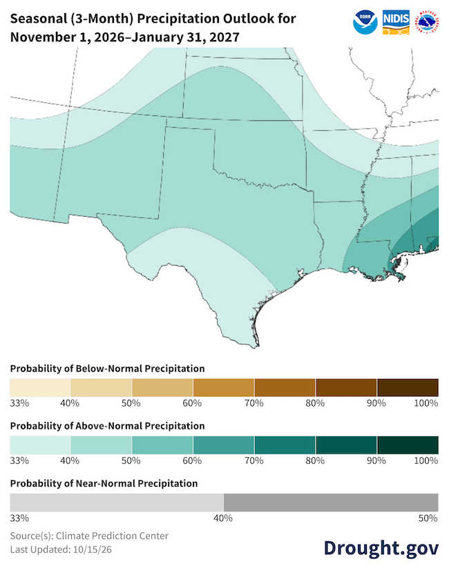
- A wetter-than-normal winter is likely. Winter precipitation will likely remove short-term drought and significantly improve long-term drought for most of the region.
This update is based on data available as of Tuesday, October 20, 2026 at 8:00 a.m. MT. We acknowledge that conditions are evolving.
Statewide average temperature ranks for September 2026, based on a 132-year period of record. Red hues indicate above-average September temperatures, and dark red indicates a record warm September.
Record-warm September temperatures spanned the Southern Plains, Central Plains, and middle and lower Mississippi Valley.
Air temperature can have wide-ranging effects on natural processes. Warmer air temperatures increase evapotranspiration—which is the combination of evaporation from the soil and bodies of water and transpiration from plants—and lower soil moisture.
Learn MoreStatewide Average Temperature Rankings (September 2026)
Statewide average temperature ranks for September 2026, based on a 132-year period of record. Red hues indicate above-average September temperatures, and dark red indicates a record warm September.
Record-warm September temperatures spanned the Southern Plains, Central Plains, and middle and lower Mississippi Valley.
Statewide average temperature ranks are available on a monthly basis from NOAA’s National Centers for Environmental Information's Climate at a Glance tool. September 2026 data were released on October 8, 2026.
Air temperature can have wide-ranging effects on natural processes. Warmer air temperatures increase evapotranspiration—which is the combination of evaporation from the soil and bodies of water and transpiration from plants—and lower soil moisture.
Learn MoreRecent Drought Conditions for the Southern Plains
- Record warm September: September 2026 was the warmest on record for Southern Plains states of Kansas, Oklahoma, and Texas, as well as surrounding states.
- The Kansas statewide average temperature for September was 8.7ºF above normal. September 2026 was the 13th consecutive month of above-average temperatures for Kansas.
- For Oklahoma, September was 9.7ºF above normal. This is 3.1ºF warmer than the previous September record.
- For Texas, September was 8.2ºF above normal. This was the record warmest September for 225 Texas counties.
- On average, the entire Southern Plains Drought Early Warning System was 8.8ºF above normal, compared to previous Septembers.
- Drought expanded in September: The heat and low rainfall totals led to drought expansion through September. By the end of September, 84% of the Southern Plains was in drought, according to the U.S. Drought Monitor. This is the largest area in drought since 2022.
- High temperatures and low soil moisture delayed winter wheat seeding in Oklahoma.
- Fall foliage is relatively muted this fall likely due to prolonged heat and lower rainfall.
- Hurricane Polo brought heavy rain to the region: The remnants of Hurricane Polo combined with a slow-moving cold front and stalled over Texas, Oklahoma, and southwest Kansas from September 28 through October 3.
- For about a week, the Southern Plains faced severe weather, heavy rainfall, flash flooding, and infrastructure disruptions. Dozens of tornados were reported during this week in Kansas and Oklahoma.
- On October 1, the Dallas-Fort Worth Airport experienced its 9th wettest day on record. Dallas County was in Exceptional Drought (D4) at the time.
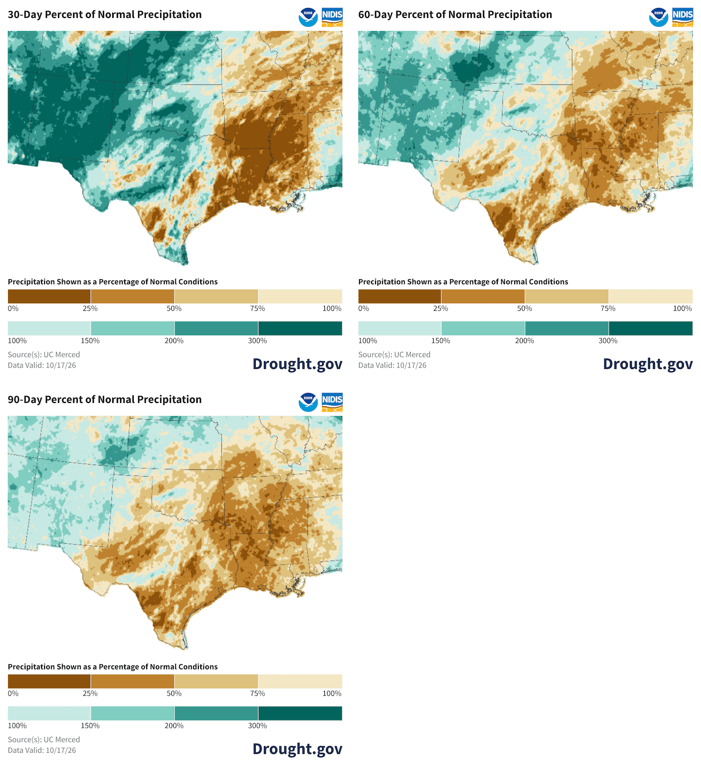
- Late September/early October rain helped with short-term drought, but did not remove drought: With the return of rain to the Southern Plains in the last week of September, short-term drought improved. However, one really good week of rain was not enough to compensate for a dry summer, and long-term precipitation deficits remain.
- Before the rain from Hurricane Polo, Dallas went 67 consecutive days (July 16-September 20) without rainfall, a tie for the second longest dry streak on record for north Texas.
- Texas Panhandle farmers reported the early October moisture they received in pooled on the surface and did not seep to soil depths.
Late September/Early October Rain Doesn't Make up for a Long, Dry Summer in the Southern Plains
Outlooks and Potential Impacts for the Southern Plains
- A wetter-than-normal winter is expected for the Southern Plains: El Niño-driven precipitation will likely remove short-term drought, and significantly improve (or possibly remove) long-term drought for most of the region.
- On average, the impacts of El Niño are most reliable farther south. However, winter 2026 will experience an unusually strong El Niño, and the pattern may not reflect past events.
- Winter forecast confidence for Southern Texas: Computer model forecasts of the atmosphere and ocean from early October show a distinct possibility of dry conditions in southern Texas. The official precipitation outlook predicts above-normal precipitation over southern Texas, but with lower confidence. Above-normal precipitation is still favored there and elsewhere in the Southern Plains.
Winter Precipitation Outlook is Optimistic for the Southern Plains
Additional Resources
More local information is available from the following resources:
- Your state climatologist
- Your state page on Drought.gov:
- National Weather Service Drought Information Statements:
More state and regional information is available from the following resources:
- Kansas: Climate and Drought in Kansas; Kansas Water Office; State Climate Office
- Oklahoma: Oklahoma Water Resources Board | Drought Monitoring; Oklahoma Mesonet Drought Tools; State Climate Office
- Texas: Texas Water Development Board | Drought; Texas Commission on Environmental Quality | Drought in Texas; Drought Dashboard: Water Data for Texas; Water Data for Texas | Texas Reservoirs; State Climate Office
- Regional: Southern Regional Climate Center, High Plains Regional Climate Center; Southern Climate Impacts Planning Program (SCIPP)
To report or view local drought impact information:
Prepared By
Joel Lisonbee
Cooperative Institute for Research in Environmental Sciences/University of Colorado Boulder and NOAA’s National Integrated Drought Information System, Southern Plains Drought Early Warning System
John Nielsen-Gammon, B.J. Baule, and Alison Tarter
Office of the Texas State Climatologist, Southern Regional Climate Center, Texas A&M University
Gary McManus
Oklahoma Climatological Survey, Oklahoma State Climate Office
Matt Sittel
Kansas State Climate Office, Kansas State University
Mack Morris
National Weather Service, New Braunfels, Texas
This Drought Status Update is issued in partnership between the National Oceanic and Atmospheric Administration (NOAA) and partners to communicate a potential area of concern for drought expansion and/or development within the Southern Plains Drought Early Warning System region based on recent conditions and the upcoming forecast. NIDIS and its partners will issue future Drought Status Updates as conditions evolve. NIDIS is an interagency program within the Climate Program Office, which is part of NOAA’s Office of Oceanic and Atmospheric Research.