Drought Worsened Across the U.S. Virgin Islands and Is Expected to Continue across the U.S. Virgin Islands, Eastern and Southern Puerto Rico.
Key Points
- Regional: Drought conditions continue to worsen across the U.S. Virgin Islands, where St. Thomas is now under Exceptional Drought (D4). In Puerto Rico, a tropical wave in late September brought significant rainfall following a dry summer, easing short-term drought conditions for most of the island and replenishing some of the reservoirs that supply the San Juan metro area. However, Extreme Drought (D3) persists across the southern plains.
- Puerto Rico Impacts: Even with the short-term improvement, some areas have not fully recovered from the severe summer drought conditions. Farmers reported agricultural losses in the south and interior of Puerto Rico. Water rationing continued for those farmers connected to the irrigation system in the south. In August, water rationing was also established for a significant portion of the San Juan metro area and additional municipalities in the northeast.
- U.S. Virgin Islands Impacts: Groundwater levels in the U.S. Virgin Islands are low and, without rain, cannot recharge. While St. Croix and St. John received some rain, it has not been enough to increase groundwater levels or soil moisture. Water consumption and production from desalination are roughly equal. Farmers reported crop losses and higher-than-normal mortality rates for poultry and livestock. The U.S. Department of Agriculture approved a secretarial Drought Disaster Declaration for the U.S. Virgin Islands on August 20, 2026.
- Looking ahead: El Niño is expected to continue strengthening through the end of 2026. Usually, the region sees a below-normal precipitation pattern with such strong El Niño events. Drought is expected to persist across the U.S. Virgin Islands and eastern and southern Puerto Rico through the remainder of the year.
See below for additional details on current conditions, impacts (including streamflow and soil moisture), and outlooks.
U.S. Drought Monitor map for Puerto Rico and the U.S. Virgin Islands, as of July 21, 2026. The U.S. Drought Monitor is updated each Thursday to show the location and intensity of drought across the country.
The map uses 5 classifications: Abnormally Dry (D0), showing areas that may be going into or are coming out of drought, and four levels of drought (D1–D4).
A drought index combines multiple drought indicators (e.g., precipitation, temperature, soil moisture) to depict drought conditions. For some products, like the U.S. Drought Monitor, authors combine their analysis of drought indicators with input from local observers. Other drought indices, like the Standardized Precipitation Index (SPI), use an objective calculation to describe the severity, location, timing, and/or duration of drought.
Learn MorePeriods of drought can lead to inadequate water supply, threatening the health, safety, and welfare of communities. Streamflow, groundwater, reservoir, and snowpack data are key to monitoring and forecasting water supply.
Learn MoreDrought can reduce the water availability and water quality necessary for productive farms, ranches, and grazing lands, resulting in significant negative direct and indirect economic impacts to the agricultural sector. Monitoring agricultural drought typically focuses on examining levels of precipitation, evaporative demand, soil moisture, and surface/groundwater quantity and quality.
Learn MoreU.S. Drought Monitor
D0 - Abnormally Dry
Abnormally Dry (D0) indicates a region that is going into or coming out of drought, according to the U.S. Drought Monitor. View typical impacts by state.
D1 – Moderate Drought
Moderate Drought (D1) is the first of four drought categories (D1–D4), according to the U.S. Drought Monitor. View typical impacts by state.
D2 – Severe Drought
Severe Drought (D2) is the second of four drought categories (D1–D4), according to the U.S. Drought Monitor. View typical impacts by state.
D3 – Extreme Drought
Extreme Drought (D3) is the third of four drought categories (D1–D4), according to the U.S. Drought Monitor. View typical impacts by state.
D4 – Exceptional Drought
Exceptional Drought (D4) is the most intense drought category, according to the U.S. Drought Monitor. View typical impacts by state.
U.S. Drought Monitor map for Puerto Rico and the U.S. Virgin Islands, as of July 21, 2026. The U.S. Drought Monitor is updated each Thursday to show the location and intensity of drought across the country.
The map uses 5 classifications: Abnormally Dry (D0), showing areas that may be going into or are coming out of drought, and four levels of drought (D1–D4).
The U.S. Drought Monitor is updated weekly on Thursday morning, with data valid through that Tuesday at 7 a.m. EDT.
A drought index combines multiple drought indicators (e.g., precipitation, temperature, soil moisture) to depict drought conditions. For some products, like the U.S. Drought Monitor, authors combine their analysis of drought indicators with input from local observers. Other drought indices, like the Standardized Precipitation Index (SPI), use an objective calculation to describe the severity, location, timing, and/or duration of drought.
Learn MorePeriods of drought can lead to inadequate water supply, threatening the health, safety, and welfare of communities. Streamflow, groundwater, reservoir, and snowpack data are key to monitoring and forecasting water supply.
Learn MoreDrought can reduce the water availability and water quality necessary for productive farms, ranches, and grazing lands, resulting in significant negative direct and indirect economic impacts to the agricultural sector. Monitoring agricultural drought typically focuses on examining levels of precipitation, evaporative demand, soil moisture, and surface/groundwater quantity and quality.
Learn MoreThis update is based on data available as of 5:00 p.m. AT on Tuesday, October 6, 2026. We acknowledge that conditions are evolving.
Current Drought Conditions
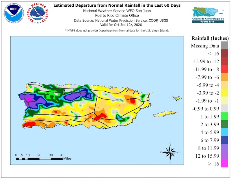
- According to the U.S. Drought Monitor, Exceptional Drought (D4) conditions are now present in St. Thomas, while Extreme Drought (D3) persists in St. John and St. Croix. In Puerto Rico, Severe Drought (D2) covers a portion of the south and east-interior, with Moderate Drought (D1) and Abnormal Dryness (D0) covering the east. For the southern plains of Puerto Rico, Extreme Drought persists (D3), with impacts mostly observed in the agricultural sector.
- The current drought conditions are largely due to the exceptionally hot and dry summer across Puerto Rico and the U.S. Virgin Islands. Juncos and Aibonito recorded their warmest summers on record. San Juan, Juncos, Arecibo, and Aibonito recorded their driest summers on record.
- Over the past six months, the station at the Luis Muñoz Marín Airport in Puerto Rico collected only 16.80 inches, roughly 50% of normal. This is the third driest such period since records began. Conditions did improve in September, with rainfall accumulations of 6.81 inches, nearly double the amount of rainfall received through the entire summer (3.98 inches in June–August).
- Conditions were also very dry across the U.S. Virgin Islands. Bordeaux, near Saint Thomas, received just 1.89 inches for the summer season, less than 20% of normal. Rainfall was below average across much of Saint Croix, though remnants of Tropical Storm Dolly provided beneficial rainfall in late August.
Puerto Rico’s South and Eastern Half Remain Dry
Agriculture, Forest, and Wildfire Impacts for Puerto Rico and the U.S. Virgin Islands
Report your Impacts: To report the effects of dry conditions on your farm projects for future Drought Updates, use the Drought Condition Monitoring Observations and Reports (CMOR) tool or join the Caribbean Climate Hub reporting chat on WhatsApp.
Puerto Rico Impacts
Island-Wide Wildfires:
- Fire danger remains low in all fire weather zones across Puerto Rico following late September rains. Fire risk could increase—particularly in southwestern Puerto Rico—due to continued dry conditions in the southwest, below-normal precipitation over the south and east, and strengthening El Niño conditions through the end of the year.
North:
- Canóvanas: Rainfall has consisted mainly of light showers that wet the surface but do not penetrate the soil. Some trees are beginning to recover, while others continue to show drought damage, including dead branches that require pruning.
Central Interior:
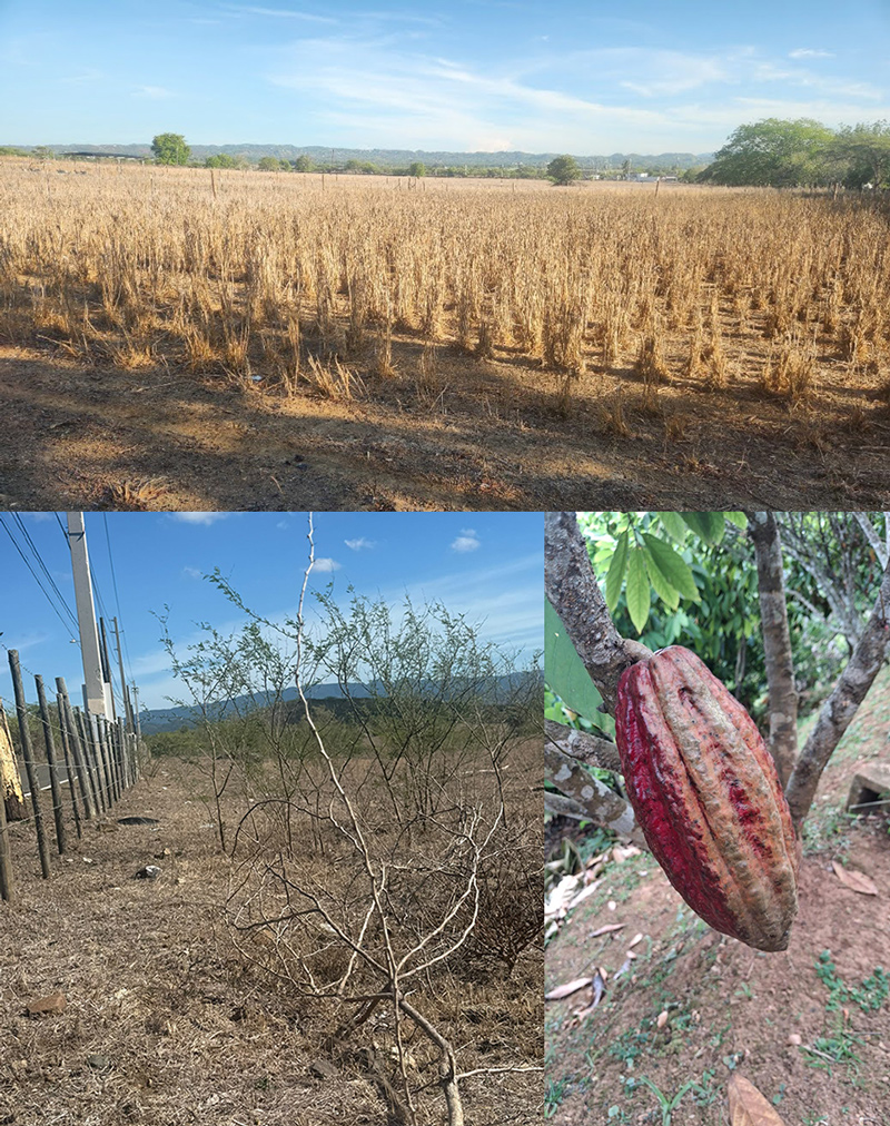
- Naranjito: A cacao farmer reports regular rainfall has resumed, but earlier drought conditions are expected to significantly reduce the upcoming harvest. He estimates October production could decline by approximately 75%. Of four production areas, three currently have no fruit. The only area producing fruit received supplemental water and fertilizer, and benefited from a small rainfall event that supported flowering and fruit set. The producer reports that one continuous month without meaningful rainfall left soils dry and cracked and substantially affected production.
South:
- Coamo: Sporadic heavy showers occurred during the past two weeks, although rainfall events were brief rather than sustained over several hours or days. Despite continued high temperatures, conditions are improving. Soils have not cracked, hay fields are showing positive responses, and rainfall has penetrated the soil. Fruit trees that had previously experienced heat stress are showing new growth, vegetation is greener, and no forest fires have been observed.
Southwest:
- Cabo Rojo: Producers report intense drought conditions, with very little rainfall since May, although some showers occurred in recent weeks. Many plants died, including cacao, while producers have maintained coffee crops through sprinkler irrigation. Despite irrigation efforts, substantial crop and plant losses have occurred. Forest vegetation has also lost considerable density, becoming sparse enough to see through the canopy—conditions that haven’t been observed in 10 years, according to one producer’s report.
- Lajas Valley:
- Drought conditions persist, with little to no meaningful rainfall. At one farm, only 0.25 inches of rain fell across three events in recent days. Since the drought began in March 2026, one producer has recorded only 2.30 inches of cumulative rainfall, distributed among rain events ranging from 0.05 to 0.75 inches. Another producer reports no precipitation during the past two weeks. Winds have decreased, but daily temperatures remain around 90 °F.
- Livestock and dairy producers continue to report extremely dry conditions, with little to no pasture available for cattle. Pasture conditions remain severely affected by the prolonged lack of rainfall.
- A primarily rainfed farm with limited irrigation experienced crop losses during the drought. Red bean seeds and cassava planted before the onset of the drought failed due to dry conditions, while dwarf banana plants experienced drought stress. Service plants (Tithonia and Canavalia) and young fruit trees showed tolerance to the dry conditions.
West:
- Mayagüez: Dry periods have been relatively short and have not resulted in reported agricultural losses. In contrast to southwestern Puerto Rico, the area is now experiencing abundant rainfall.
Dry Soils and Agricultural Impacts in Puerto Rico
U.S. Virgin Islands Impacts
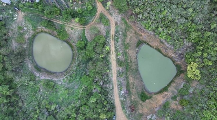
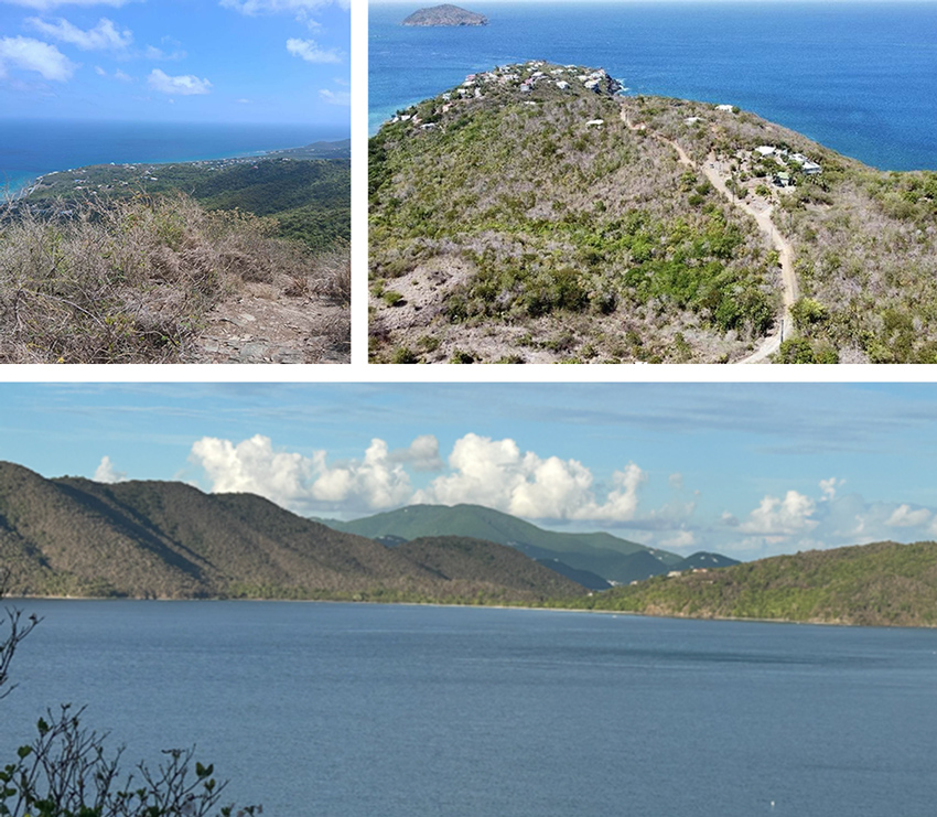
- Impacts Across All Three Islands: Soils throughout the territory are extremely dry, with limited forage and dried up ponds, forcing producers to conserve water or buy deliveries at high costs ($450 per 5,000 gallons). Water shortages affect all three islands. Feed stores offer hay at $30–$35 per bale while the Virgin Islands Department of Agriculture (VIDA) is not able to offer baling services in the St. Thomas/St. John district due to machinery shortages. Severe livestock and poultry losses, along with crop damage, are widely reported. Wildlife—including deer and birds—are migrating closer to homes for food and water, while wild poultry numbers decline. These rising feed and water costs create strain on farmers. There is heightened wildfire risk from persistent dry, gusty conditions.
- St. Thomas: Farmers report the drought has depleted soil moisture. Livestock losses continue. Pond water availability ranges from none to negligible, and farmers are conserving water. Producers are culling animals and separating males and females. Poultry farmers report early molting, which they believe is due to heat. Orchard farmers are losing trees; avocados are smaller; and coconut and banana trees are dying. Mangoes and dragon fruit trees continue to flower and produce, despite dry conditions.
- St. John: Hot, dry weather is adversely impacting fruit trees, row crops, and specialty crops. Many ponds are dry, and soil moisture is limited, with cracks beginning to show. Farmers report that trees, including bananas, are falling over. Producers are conserving water and not planting, and are planning long-term mitigation strategies, including land management and irrigation. With little rain falling, many producers are concerned about the drought persisting through the coming months. Livestock and poultry losses continue.
- St. Croix: St. Croix farmers report intermittent rain and sporadic windy conditions. Livestock farmers report losses, including sheep, goats, and cattle. Wildlife, including deer and birds, are also impacted. Dry soils and limited forage are adversely affecting all livestock. Poultry farmers report early molting in June rather than August. Soil cracks measure up to 24 inches deep, along with deep holes. Most agricultural producers, including specialty and row crop farmers, report soil moisture is nearly nonexistent. A Medfly outbreak has triggered the first federal quarantine in the U.S. Virgin Islands.
Ponds Are Low on St. Thomas
Dry Vegetation Across the U.S. Virgin Islands
Puerto Rico Streamflow and Soil Moisture Impacts
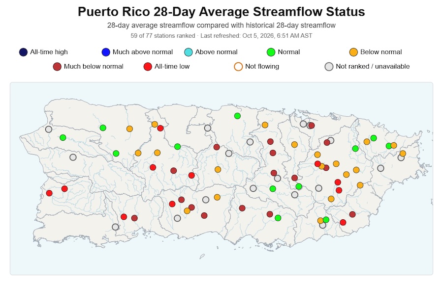
- Streamflows are mostly below to much-below normal, but some areas are showing signs of improving.
- Groundwater levels in the southern aquifer remain under considerable drought stress, as monitored by the U.S. Geological Survey. Two wells are at critical thresholds according to the Puerto Rico Department of Natural and Environmental Resources, indicating urgent concern. The remaining wells are operating between necessary operational adjustments and optimal conditions. Groundwater conditions are also low in the U.S. Virgin Islands.
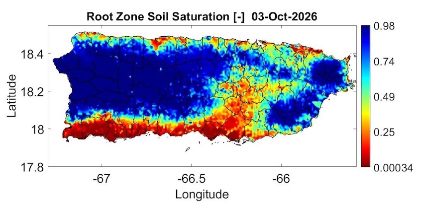
- According to the Puerto Rico Agricultural Water Management, root zone soil saturation shows dry soils persisting across the south and east-interior. However, wetter soils are now present along the central interior, west, and east.
Streamflows Are Mostly Below Normal
Soils Are Dry Across Puerto Rico’s South and East-Interior, but Wetter along the Central interior, West, and East
Outlooks and Potential Impacts for Puerto Rico and the U.S. Virgin Islands
- Forecast models indicate below-normal precipitation (50–60% chance) and above-normal temperatures (greater than 70% chance) will persist through the early winter months. Conditions are expected to lean closer to normal by late winter and early spring 2027.
- The current El Niño event is expected to continue strengthening, with a 90% chance of a very strong event during the Northern Hemisphere fall and winter 2026–2027. Puerto Rico and the U.S. Virgin Islands often experience below-normal precipitation with such strong El Niño events. However, every El Niño is different, and other factors can affect winter conditions.
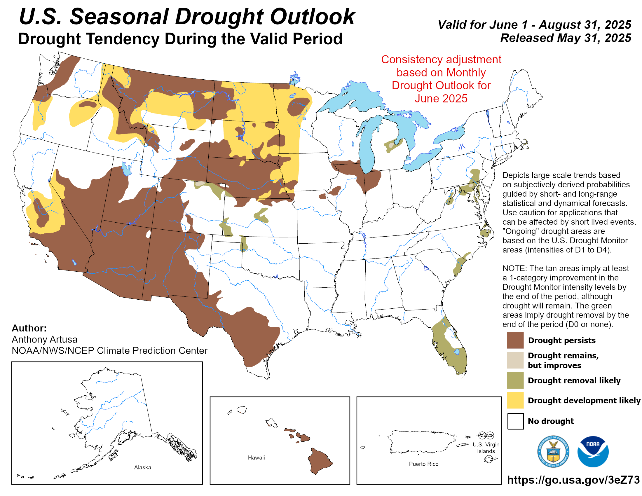
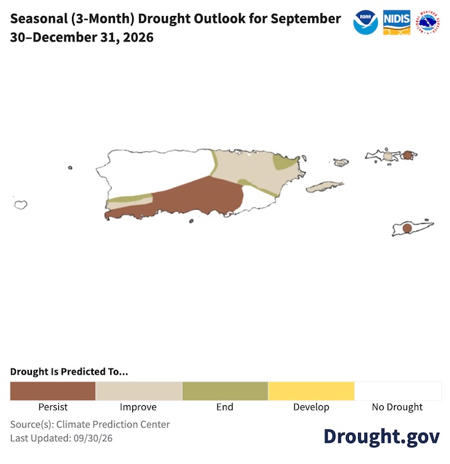
- According to the latest NOAA Seasonal Drought Outlook, drought is expected to persist across the U.S. Virgin Islands and eastern and southern Puerto Rico over the next three months. Drought is expected to improve in the northeast, and will likely not develop along the northwest quadrant of Puerto Rico.
Drought Is Expected to Persist Across the U.S. Virgin Islands and Eastern and Southern Puerto Rico
Additional Resources
National Weather Service Weather Forecast Offices:
- Read the Drought Information Statement for Puerto Rico and the U.S. Virgin Islands (September 24, 2026) by the National Weather Service San Juan
- San Juan Climate and Drought Information
- Puerto Rico and U.S. Virgin Islands Fire Weather Information
U.S. Drought Portal (Drought.gov):
USDA Caribbean Climate Hub:
- Archive of weekly Puerto Rico drought records developed by the Puerto Rico Scientific Drought Committee
- Drought and disaster assistance resources for tropical forestry and agriculture
- Caribbean Drought Learning Network
Southeast Regional Climate Center:
- Quarterly Climate Impact and Outlook Reports (September 2026), which includes Puerto Rico and U.S. Virgin Islands.
Prepared By
Emanuel Rodríguez-González
NOAA National Weather Service, San Juan Weather Forecast Office
Nora L. Álvarez-Berríos
International Institute of Tropical Forestry (IITF), USDA Forest Service
Tania Cordero-Rosario
Puerto Rico Association of Soil Conservation Districts, U.S. Department of Agriculture (USDA) Caribbean Climate Hub
Christina Chanes
Virgin Islands Department of Planning & Natural Resources
Meredith Muth
NOAA National Integrated Drought Information System (NIDIS)
Héctor J. Jiménez
University of Puerto Rico Office of Climatology
William A. Gould
USDA Caribbean Climate Hub, USDA Forest Service Research and Development
Elliot Sosa
U.S. Geological Survey, Caribbean–Florida Water Science Center (CFWSC)
Brad Rippey
USDA Office of the Chief Economist
Puerto Rico Reporting Input: Special thanks to agronomists, extension agents, researchers, volunteers, ranchers, and farmers: Harry Ramírez, Neftali Lluch, Diana Guzmán, Luz Jimenez, Mara Semidei, Alana Toro-Ramos, Isela Ortiz, Georges Felix, and Jorge Morales.
USVI Reporting Input: Several individuals contributed to this report, and we are acknowledging the following for their support, including the farming community across the USVI, the VI Department of Planning and Natural Resources, Division of Fish and Wildlife, VI Department of Agriculture, as well as the USDA Office Chief Economist, National Park Service in St. Croix and St. John, USDA Farm Service Agency, USDA Natural Resources Conservation Service in St. Croix, Coral Bay Community Council, and the many volunteer drought reporters, volunteers, and farmers from across the territory.
About This Report
This drought update is issued in partnership between the National Integrated Drought Information System (NIDIS), National Oceanic and Atmospheric Administration (NOAA) National Weather Service, the U.S. Department of Agriculture (USDA), and the University of the Virgin Islands. The purpose of the update is to communicate a potential area of concern for drought expansion and/or development within Puerto Rico and the U.S. Virgin Islands based on recent conditions and the upcoming three-month forecast. NIDIS is an interagency program within the Climate Program Office, which is part of NOAA's Office of Oceanic and Atmospheric Research.
NIDIS and its partners will issue these updates every two months. Subscribe for these U.S. Caribbean drought updates.