Drought Develops in Maine, New York, and Vermont; Record 30-Day Rainfall Deficits in Central New York
Key Points:
- Moderate Drought (D1) was introduced in northern portions of Vermont and Maine, and several New York counties—just north of the Pennsylvania border.
- Abnormally Dry conditions (D0) expanded dramatically across New York state, going from 2% coverage as of May 23 to 82% coverage as of June 6. Minor expansions of D0 also occurred elsewhere in the region.
- As Abnormal Dryness expands and Moderate Drought develops, impact reports have begun to come in:
- In the June 8 meeting of New York State field crop interests, the consensus was that rain is sorely needed. Waterways in northern New York have dropped significantly since the precipitation events in late April and early May, which did little for many fields. High evapotranspiration rates in more recent weeks are exacerbating conditions.
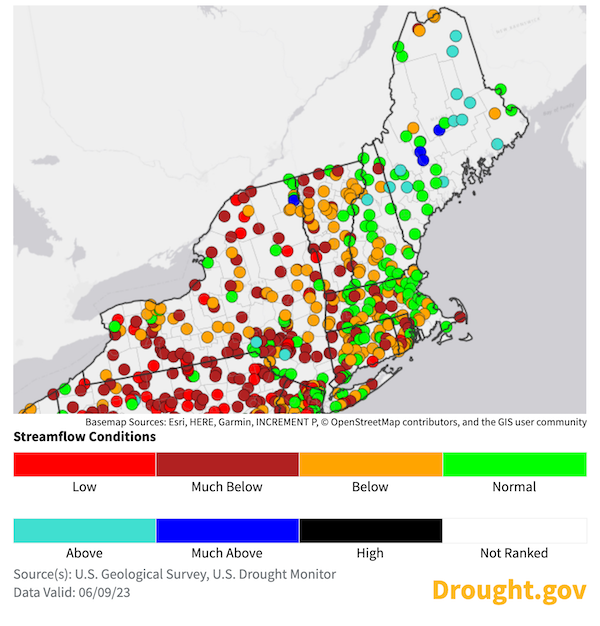
- Deterioration of conditions across much of New York, Vermont, and northern New Hampshire and Maine are reflected in the below-normal, much-below-normal, and low streamflow conditions for the 7-, 14-, and 28-day periods.
- In New York, this past week’s Condition Monitoring Observer Reports (CMOR) speak to reduced streamflow with warmer water temperatures, drying ponds and wetlands, along with concerns for drinking water quality and availability from some wells.
- Precipitation chances increase through Friday and again for early next week for most of the region. Areas that see rain will see some relief from dryness and smoke but the totals will need to be significant to ease the building deficits.
- Above-normal significant wildland fire potential is predicted for parts of the Northeast in July and August, according to the National Interagency Fire Center.
More CMOR, Please!
Condition Monitoring Observer Reports (CMOR) help us understand how drought and dryness are impacting you at the local level. These descriptions are a supplement to other data that are collected, and are often used by the U.S. Drought Monitor authors as a way to identify areas that may need further evaluation.
Current U.S. Drought Monitor map for the Northeast Drought Early Warning System (DEWS) with data valid for June 6, 2023. The U.S. Drought Monitor is updated each Thursday to show the location and intensity of drought across the country.
According to the latest U.S. Drought Monitor, 51.8% of the Northeast is experiencing Abnormally Dry (D0) conditions, with 5.7% in Moderate Drought (D1).
U.S. Drought Monitor Categories
Abnormally Dry (D0)
Abnormally Dry (D0) indicates a region that is going into or coming out of drought. View typical impacts by state.
Moderate Drought (D1)
Moderate Drought (D1) is the first of four drought categories (D1–D4), according to the U.S. Drought Monitor. View typical impacts by state.
Severe Drought (D2)
Severe Drought (D2) is the second of four drought categories (D1–D4), according to the U.S. Drought Monitor. View typical impacts by state.
Extreme Drought (D3)
Extreme Drought (D3) is the third of four drought categories (D1–D4), according to the U.S. Drought Monitor. View typical impacts by state.
Exceptional Drought (D4)
Exceptional Drought (D4) is the most intense drought category, according to the U.S. Drought Monitor. View typical impacts by state.
Current U.S. Drought Monitor map for the Northeast Drought Early Warning System (DEWS) with data valid for June 6, 2023. The U.S. Drought Monitor is updated each Thursday to show the location and intensity of drought across the country.
According to the latest U.S. Drought Monitor, 51.8% of the Northeast is experiencing Abnormally Dry (D0) conditions, with 5.7% in Moderate Drought (D1).
The U.S. Drought Monitor map is updated weekly on Thursday mornings, with data valid through the previous Tuesday at 7 a.m. Eastern.
Current Conditions
| Station | Number of Days | Historical Ranking | Period of Record |
|---|---|---|---|
| Ithaca, NY | 26 | 2 | 1893–2023 |
| LaGuardia, NY | 26 | 1 | 1940–2023 |
| Boston, mA | 23 | 15 | 1872–2023 |
| Burlington, VT | 24 | 4 | 1884–2023 |
| Binghamton, NY | 29 | 1 | 1951–2023 |
| Buffalo, NY | 28 | 1 | 1871–2023 |
| Caribou, ME | 17 | 32 | 1939–2023 |
| Albany, NY | 26 | 2 | 1874–2023 |
| Philadelphia, PA | 27 | 1 | 1872–2023 |
Number of days without measurable precipitation for selected stations, from May 8–June 6, 2023. Note: Period of record (POR) does vary for each site. Source: Northeast Regional Climate Center, ACIS.
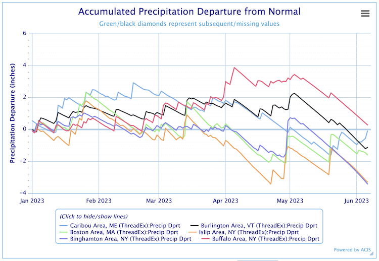
Accumulated Precipitation Departure from Normal
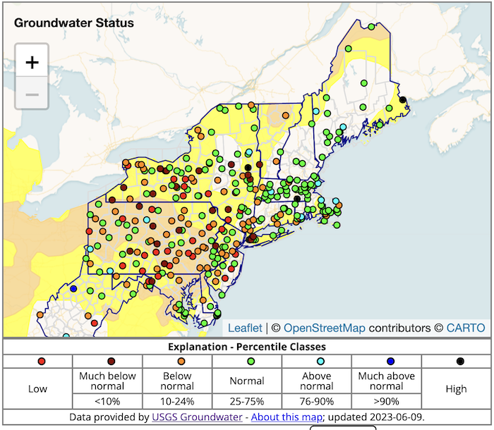
New England Groundwater Levels
Real-Time Streamflow Conditions: June 9, 2023
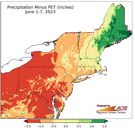
Precipitation Minus Potential Evapotranspiration: June 1–7
State-Reported Conditions and Impacts
Connecticut
Maine
Massachusetts
- Massachusetts Drought Management Task Force
- Impacts:
- June 8, 2023: Drought Task Force Meeting (recommendations pending):
- Cities and Towns Posting Water Restrictions
- Water Resources Toolkit available to communities for messaging
- May 30, 2023: The Salem News – Impacts on Ipswich River Recreation
- May 30, 2023: CBS WBZ News – Smoke from Nova Scotia Wildfires
- June 8, 2023: Drought Task Force Meeting (recommendations pending):
New Hampshire
New York
- New York State Department of Environmental Conservation (DEC): Drought
- Impacts:
- June 6, 2023: Department of Environmental Conservation – Prescribed and Wildfire Updates
- June 2, 2023: The Village of Endicott – Conserve Water Advisory
- June 2, 2023: Department of Environmental Conservation – Canadian Wildfire Control Assistance, High Fire Risk in NYS and Air Quality
- June 1, 2023: NYup.com – Upstate New York Headed Toward Drought
- May 31, 2023: MyTwinTiers.com – Could Dry Conditions Affect Local Vineyards?
- May 24, 2023: Hudson Valley News – Kingston’s Water Management Efforts
- May 24, 2023: WNYC Gothamist – Wildfires in New York and New Jersey
Rhode Island
- Rhode Island Water Resources Board: Drought Management Program
- Impacts:
- June 5, 2023: Johnston Sunrise – Mini Clover for Drought-Tolerant Lawns
Vermont
- Vermont Agency of Natural Resources, Department of Environmental Conservation: Drought and Other Hazards
- Impacts:
- May 29, 2023: Valley News – Threats to the Region’s Trout
Northeast
- June 7, 2023: The Washington Post – More Fires, Smoke, and Poor Air Quality
- June 6, 2023: National Weather Service Storm Prediction Center Twitter – Dry, Breezy Conditions and Possible Dry Thunderstorms May Aggravate Fire Conditions
- June 6, 2023: The Washington Post – Midwest, Northeast Fire Threat
- June 6, 2023: American Agriculturist – Worried About Drought, Watch These Indicators
- June 2, 2023: Yahoo News – Northeast and Midwest at Risk of Flash Drought
- June 4, 2023: USDA National Agricultural Statistics Service (NASS) Crop Progress & Condition Reports for New York and New England
Find additional impacts through the National Drought Mitigation Center’s Drought Impact Reporter.
Visit the new Drought.gov state pages for additional maps and resources. Or, find local drought information by address, city or zip code on Drought.gov.
Outlooks
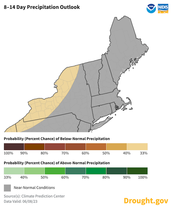
8–14 Day Temperature and Precipitation Outlooks: June 16–22
Near-normal temperatures are expected for the coastline, with warmer-than-normal temperatures inland. These warmer conditions inland, where agricultural efforts are more prevalent, will increase evapotranspiration and not allow for significant retention of needed rains.
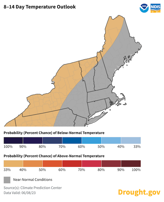
Near-normal precipitation is expected for the entire region during the period, except for western New York (which slightly favors below-normal precipitation). This could put a pause on the expansion and intensification of any dryness, but it may not be substantial enough to improve the deficits that were built up in May and early June.
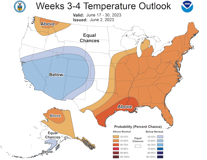
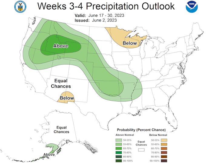
Week 3–4 Temperature and Precipitation Outlooks: June 17–30 (Issued June 2, 2023)
With odds favoring above-normal temperatures and equal chances for below- or above-normal precipitation, a trend toward expanded dryness, if not drought intensification, seems likely.
What We Are Watching
Pennsylvania
In Pennsylvania, the expansion of Abnormal Dryness (D0) and Moderate Drought (D1) was dramatic and should be monitored closely by Northeast DEWS partners bordering the state. The May 23 Drought Monitor showed 8% of the state as Abnormally Dry; the May 30 Drought Monitor showed 93% as Abnormally Dry and 5% in Moderate Drought; and the June 6 Drought Monitor showed 35% as Abnormally Dry and 65% in Moderate Drought.
In the news:
- June 7, 2023: WGAL 8 – South-Central Pennsylvania Burn Bans
- May 31, 2023: Fox News 43 - Dry May Affecting Central PA Crop Yields
Drought & Wildfire
For nearly a decade, NIDIS has worked with numerous national and state level partners, as well as the research community, to better understand the linkages between drought and wildfire. The NIDIS Drought & Wildland Fire Nexus (NDAWN) Strategy utilizes the best aspects of an integrated information system approach to facilitate a drought and wildland fire decision-support network.
In the news:
- June 8, 2023: CBS News – The Why of the Canadian Wildfires
- June 7, 2023: National Weather Service Binghamton Weather Forecast Office Twitter – No Sun; Orange Air
- June 7, 2023: CBS News – Canadian Wildfires and Impacts
- May 30, 2023: BBC News – Nova Scotia Wildfires
Featured Resources
- AirNow.Gov
- Drought and Public Health: A Roadmap for Advancing Engagement and Preparedness
- Dry Times: The Wildfire Issue: June 8, 2023 edition of NIDIS's bi-weekly drought newsletter
- National Drought Mitigation Center: Learn more about the latest U.S. Drought Monitor, including tutorials
- U.S. Climate Resilience Toolkit: Northeast
- Internet of Water Coalition: Unlocking the Full Potential of Water Data: USGS and the Internet of Water
- National Drought Mitigation Center: U.S .Drought Impact Summary for May 2023
In Case You Missed It
- Flash Drought Monitoring Tools (PDF): From presentations during the 2021 Flash Drought Webinar Series, 2023 National Flash Drought Workshop, and subsequent discussions with subject matter experts, NIDIS developed this handout listing currently available flash drought-oriented prediction and monitoring tools.
- NIDIS will host the 2023 National Soil Moisture Workshop this August. Learn more and register now.
Additional Resources
- Look back at previous Northeast DEWS Drought Status Updates
- Your local National Weather Service office
- NOAA Regional Climate Services Monthly Webinar Series (next webinar is on June 29)
- USDA Northeast Climate Hub
- USGS New England and New York Water Science Centers
Contacts for More Information
Sylvia Reeves
Regional Drought Information Coordinator (Northeast DEWS)
NOAA/CIRES/National Integrated Drought Information System (NIDIS)
Email: sylvia.reeves@noaa.gov
Ellen L. Mecray
Regional Climate Services Director, Eastern Region
NOAA/NESDIS/National Centers for Environmental Information
Email: Ellen.L.Mecray@noaa.gov
Prepared By
Sylvia Reeves
NOAA/National Integrated Drought Information System (NIDIS), CIRES
Samantha Borisoff, Jessica Spaccio, Keith Eggleston, Art DeGaetano, Natalie Umphlett
Northeast Regional Climate Center
Ellen Mecray
Regional Climate Services Director, Eastern Region, NOAA
Gardner Bent
USGS New England Water Science Center
In partnership with National Weather Service Offices of the Northeast and State Climate Offices of the Northeast.
This drought status update is issued in partnership between the National Oceanic and Atmospheric Administration (NOAA), U.S. Geological Survey, and the U.S. Department of Agriculture (USDA) to communicate concern for drought expansion and intensification within the Northeast U.S. based on recent conditions and the forecasts and outlooks. NIDIS and its partners will issue future drought status updates as conditions evolve.
