Drought Persists and Likely to Expand as Impacts Worsen
Key Points
- Drought conditions have persisted across most of the Missouri River Basin over the last month, despite some areas of improvement. 50% of the region is in Moderate to Extreme Drought (D1-D3), according to the U.S. Drought Monitor.
- Extreme Drought (D3) conditions are present in western North Dakota, southwestern South Dakota, eastern Wyoming, and western Nebraska. Drought conditions are most widespread across Nebraska and South Dakota with 100% of those states experiencing Abnormally Dry to Extreme Drought (D0-D3).
- Drought conditions improved over the past few weeks in South Dakota, northern Wyoming, and across parts of North Dakota and Kansas, but drought and its impacts still persist. The 2025 Water Year (since October 1) was off to a slow start across the region, with longer-term precipitation deficits mounting due to below-normal precipitation in the fall and limited winter snowpack.
- Unseasonably warm, windy, and dry conditions over the last month, in addition to long-term precipitation deficits, increased the risk for the rapid expansion and intensification of drought across the region. Timely spring and summer precipitation will be pivotal to avoid worsening drought conditions.
- April runoff fell much below normal (48%), and May runoff is forecasted to be 78% of normal, which is prompting river navigation concerns on the Missouri River going into the summer.
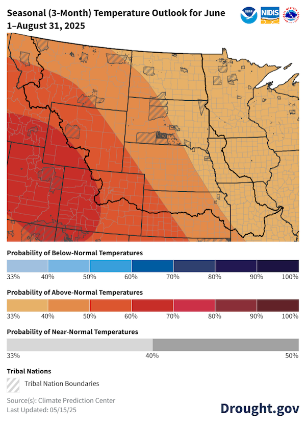
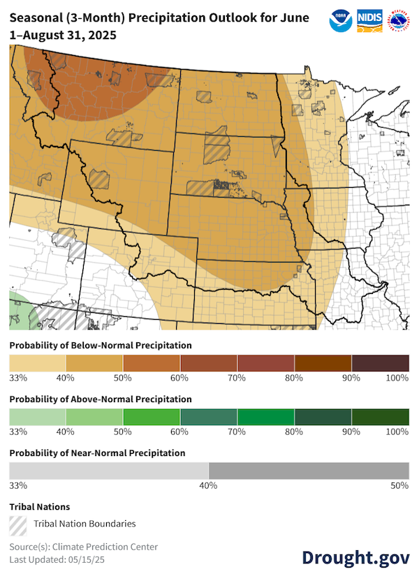
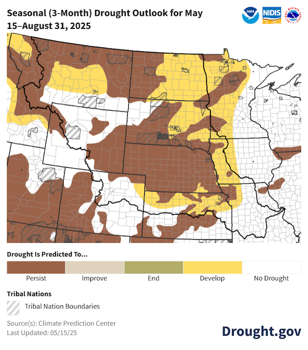
- Over the short term, forecasts show wet conditions across the Basin. The seasonal outlooks for June–August 2025 show potential for below-normal precipitation and above-normal temperatures across all of the Basin. As a result of these outlooks, drought is expected to persist or develop across portions of all Basin states, with the entirety of North Dakota and Nebraska expected to be in drought.
The U.S. Drought Monitor depicts the location and intensity of drought across the country. The map uses 5 classifications: Abnormally Dry (D0), showing areas that may be going into or are coming out of drought, and four levels of drought (D1–D4).
The U.S. Drought Monitor is a joint effort of the National Oceanic and Atmospheric Administration, U.S. Department of Agriculture, and National Drought Mitigation Center.
A drought index combines multiple drought indicators (e.g., precipitation, temperature, soil moisture) to depict drought conditions. For some products, like the U.S. Drought Monitor, authors combine their analysis of drought indicators with input from local observers. Other drought indices, like the Standardized Precipitation Index (SPI), use an objective calculation to describe the severity, location, timing, and/or duration of drought.
Learn MorePeriods of drought can lead to inadequate water supply, threatening the health, safety, and welfare of communities. Streamflow, groundwater, reservoir, and snowpack data are key to monitoring and forecasting water supply.
Learn MoreDrought can reduce the water availability and water quality necessary for productive farms, ranches, and grazing lands, resulting in significant negative direct and indirect economic impacts to the agricultural sector. Monitoring agricultural drought typically focuses on examining levels of precipitation, evaporative demand, soil moisture, and surface/groundwater quantity and quality.
Learn MoreDrought & Dryness Categories
% AreaD0 – Abnormally Dry
Abnormally Dry (D0) indicates a region that is going into or coming out of drought. View typical impacts by state.
D1 – Moderate Drought
Moderate Drought (D1) is the first of four drought categories (D1–D4), according to the U.S. Drought Monitor. View typical impacts by state.
D2 – Severe Drought
Severe Drought (D2) is the second of four drought categories (D1–D4), according to the U.S. Drought Monitor. View typical impacts by state.
D3 – Extreme Drought
Extreme Drought (D3) is the third of four drought categories (D1–D4), according to the U.S. Drought Monitor. View typical impacts by state.
D4 – Exceptional Drought
Exceptional Drought (D4) is the most intense drought category, according to the U.S. Drought Monitor. View typical impacts by state.
Total Area in Drought (D1–D4)
Percent area of the states in the Missouri River Basin that is currently in drought (D1–D4), according to the U.S. Drought Monitor.
The U.S. Drought Monitor depicts the location and intensity of drought across the country. The map uses 5 classifications: Abnormally Dry (D0), showing areas that may be going into or are coming out of drought, and four levels of drought (D1–D4).
The U.S. Drought Monitor is a joint effort of the National Oceanic and Atmospheric Administration, U.S. Department of Agriculture, and National Drought Mitigation Center.
The U.S. Drought Monitor is released every Thursday morning, with data valid through the previous Tuesday at 7 a.m. ET.
A drought index combines multiple drought indicators (e.g., precipitation, temperature, soil moisture) to depict drought conditions. For some products, like the U.S. Drought Monitor, authors combine their analysis of drought indicators with input from local observers. Other drought indices, like the Standardized Precipitation Index (SPI), use an objective calculation to describe the severity, location, timing, and/or duration of drought.
Learn MorePeriods of drought can lead to inadequate water supply, threatening the health, safety, and welfare of communities. Streamflow, groundwater, reservoir, and snowpack data are key to monitoring and forecasting water supply.
Learn MoreDrought can reduce the water availability and water quality necessary for productive farms, ranches, and grazing lands, resulting in significant negative direct and indirect economic impacts to the agricultural sector. Monitoring agricultural drought typically focuses on examining levels of precipitation, evaporative demand, soil moisture, and surface/groundwater quantity and quality.
Learn MoreThis update is based on data available as of Thursday, May 15, 2025 at 8:00 a.m. CT. We acknowledge that conditions are evolving.
Current Conditions for the Missouri River Basin
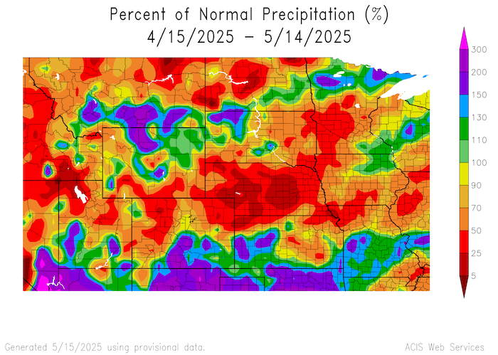
- Drought conditions persisted across the Basin since the 2025 Water Year (October 1, 2024–September 30, 2025) began. Despite some recent short-term improvements, long-term deficits and impacts remain. Some of the largest precipitation deficits are found across South Dakota, Nebraska, and northern Kansas. Parts of Nebraska are noting deficits out to 240 days.
- Nebraska has seen the most significant precipitation deficits over the last 30 days, with most of the state receiving less than 50% of normal precipitation. Despite isolated areas of above-normal precipitation, deficits remain across the Basin, leading to water hauling, dry stock ponds, and groundwater wells going dry.
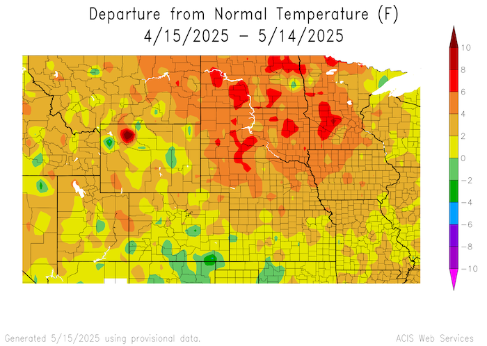
- Over the last 30 days, temperatures were above normal. Isolated parts of the Dakotas saw temperatures 4 °F to 8 °F above normal. Temperatures were much above normal over the past week, with nearly 12 °F departures across North Dakota, South Dakota, and eastern Montana.
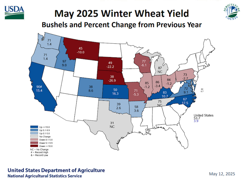
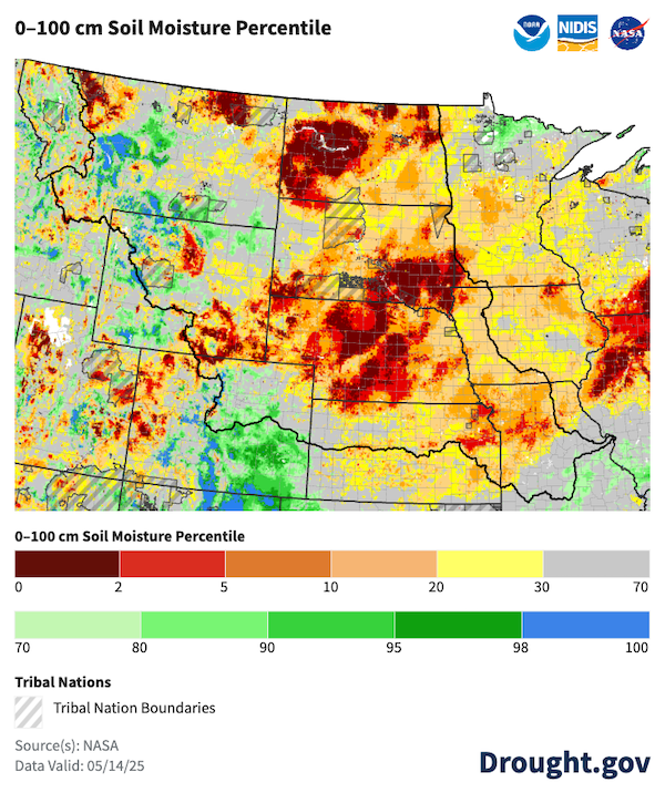
- Winter wheat yields are down 10% to 25% compared to last year in Montana, South Dakota, and Nebraska. Extremely dry soil exists across most of the Basin, and many states are experiencing soil moisture below the 10th percentile. Poor soil moisture conditions led to spring planting difficulties, delayed green up, early irrigation, fallowing of fields, and poor range conditions.
- The Dearborn River in Montana, a tributary of the Missouri River, is reporting streamflows among the lowest in the state. Mountain snowpack was below normal and peaked early in the headwaters of the Basin. Runoff into reservoirs was only 48% of normal for April. Gavins Point Dam releases continued to provide navigation flow support at a reduced flow rate of 4,000 cubic feet per second below full service.
- A lack of snow this winter and windy conditions led to an early start to the wildfire season, with large early season fires burning in South Dakota, North Dakota, and Nebraska. Much-above-normal temperatures and reported high winds across the Basin caused extremely high evaporative demand, rapidly drying the landscape.
Many Parts of the Basin Are Missing Out on Normal Spring Moisture
Above-Normal Temperatures Increase the Risk for Further Drought Development
Winter Wheat Yield Impacted by Drought Conditions
Soil Moisture Remains Exceptionally Dry
Outlooks and Potential Impacts for the Missouri River Basin
- Forecasts for the next seven days show widespread rainfall across the northern reaches of the Basin. If forecasts pan out, this moisture will improve soil moisture, crop, and streamflow conditions. Short-term benefits may still not greatly improve long-term deficits.
- NOAA's Climate Prediction Center's 8-14 day outlooks slightly favor below-normal precipitation across most of the Basin, but near-normal precipitation for parts of Kansas and southern Nebraska. Temperatures are favored to be above normal across the western half of the Basin and near normal to below normal for the eastern half of the Basin.
- The three-month outlooks for June–August show increased chances for above-normal temperatures and below-normal precipitation across the Missouri River Basin.
- As a result of this outlook, drought is expected to persist or redevelop across Montana, North Dakota, South Dakota, Wyoming, and Nebraska, with potential further expansion in North Dakota, South Dakota, and Nebraska.
- Longer-term precipitation deficits mean the Basin will rely on regular spring and summer precipitation to avoid worsening drought conditions. If unseasonably warm and dry conditions persist as forecasted, rapid expansion and intensification of drought is likely, further deepening the long-term deficits.
- May runoff is forecasted to be 78% of average for the Basin according to the U.S. Army Corps of Engineers. Potential impacts include inadequate moisture for the growing season, elevated risk for wildfire, river navigation issues, reduced recreation, wildlife impacts, and hydrological issues (e.g., low streamflow and groundwater, water supply issues).
Summer Outlooks Favor Above-Normal Temperatures and Below-Normal Precipitation
Drought Favored to Persist and Expand
Additional Resources
- More local information is available from the following resources:
- To report or view local drought impact information:
Prepared By
Jason Gerlich
Cooperative Institute for Research in Environmental Sciences (CIRES), CU Boulder
NOAA/National Integrated Drought Information System (NIDIS)
Scott Dummer
NOAA/National Weather Service Missouri Basin River Forecast Center
Denise Gutzmer
National Drought Mitigation Center
Rezaul Mahmood
High Plains Regional Climate Center
This Drought Status Update is issued in partnership between the National Oceanic and Atmospheric Administration (NOAA), U.S. Department of Agriculture (USDA), U.S. Army Corps of Engineers (USACE), University of Nebraska, State Climate Offices, Montana DNRC, and the National Drought Mitigation Center to communicate a potential area of concern for drought expansion and/or development within the Missouri River Basin based on recent conditions and the upcoming forecast. NIDIS and its partners will issue future Drought Status Updates as conditions evolve.


