Significant Drought Expected to Continue into 2022 Growing Season.
This drought status update is based on information provided in the March 17 North Central Climate and Drought Outlook Webinar (view recording for more details), as well as the NOAA Climate Prediction Center Spring 2022 Outlook.
Key Points
- Drought continues to impact a majority of the Missouri River Basin following difficult drought conditions and impacts the past two years. 79% of the basin is currently in at least moderate drought (D1), with 52% in severe drought (D2) and 18% in extreme drought (D3).
- Some of the hardest hit areas last year in the Northern Plains (Montana, North Dakota, South Dakota, and Wyoming) have seen minor improvement over winter, but not enough to alleviate drought concerns for this spring and the upcoming growing season.
- Central Plains states (eastern Colorado, Kansas, Nebraska) have seen drought intensify since the start of the water year (October 1, 2021), causing significant wildland fire issues recently and raising concerns for the upcoming growing season.
- Drought conditions have reduced the Missouri River Mainstem Reservoir System storage. As a result, drought conservation measures were implemented by the U.S. Army Corps of Engineers. Navigation flow support will be at minimum service to start the 2022 navigation season, which means an 8-foot deep navigation channel instead of a 9-foot deep channel.
- The Missouri River Basin needs periodic and regular above-normal precipitation in order to avoid further drought deterioration. While spring is typically the wettest time of the year for the basin, the April through June precipitation and temperature outlooks are leaning towards drier and warmer conditions for a majority of the basin, which will likely lead to drought persistence and potentially intensification.
- Persistent drought issues will likely lead to increased wildland fire risk, limited water supply for agriculture and livestock, crop damage and loss, water quality issues, and limitations to water supply and navigation along the Missouri River.
Current U.S. Drought Monitor map for the Missouri River Basin Drought Early Warning System (DEWS) region with data valid for March 15, 2022. The U.S. Drought Monitor (USDM) is updated each Thursday to show the location and intensity of drought across the country. Drought categories show experts’ assessments of conditions related to dryness and drought including observations of how much water is available in streams, lakes, and soils compared to usual for the same time of year.
79% of the Missouri River Basin is in drought (D1–D4), with 18% in extreme (D3) drought.
Current U.S. Drought Monitor map for the National Weather Service Central Region with data valid for March 15, 2022. The U.S. Drought Monitor (USDM) is updated each Thursday to show the location and intensity of drought across the country. Drought categories show experts’ assessments of conditions related to dryness and drought including observations of how much water is available in streams, lakes, and soils compared to usual for the same time of year.
U.S. Drought Monitor Categories
U.S. Drought Monitor Categories
Current U.S. Drought Monitor map for the Missouri River Basin Drought Early Warning System (DEWS) region with data valid for March 15, 2022. The U.S. Drought Monitor (USDM) is updated each Thursday to show the location and intensity of drought across the country. Drought categories show experts’ assessments of conditions related to dryness and drought including observations of how much water is available in streams, lakes, and soils compared to usual for the same time of year.
79% of the Missouri River Basin is in drought (D1–D4), with 18% in extreme (D3) drought.
Current U.S. Drought Monitor map for the National Weather Service Central Region with data valid for March 15, 2022. The U.S. Drought Monitor (USDM) is updated each Thursday to show the location and intensity of drought across the country. Drought categories show experts’ assessments of conditions related to dryness and drought including observations of how much water is available in streams, lakes, and soils compared to usual for the same time of year.
Current Conditions
- Drought continues to impact a majority of the Missouri River Basin (MRB) following difficult drought conditions and impacts the past two years. 79% of the basin is currently in at least moderate drought (D1), with 52% in severe drought (D2) and 18% in extreme drought (D3).
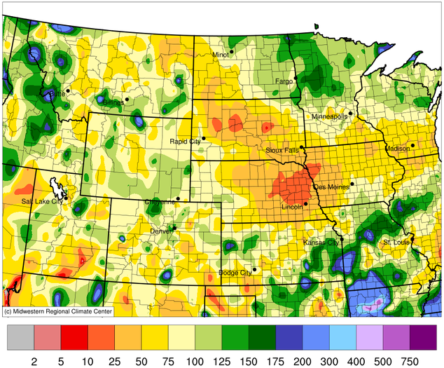
- Winter precipitation was below normal across much of the basin, particularly across Kansas and Nebraska (Figure 1), with precipitation deficits around 1–6 inches. Snowfall was below normal across the MRB too, particularly across South Dakota and Nebraska (Figure 2). Snowpack in the Plains and mountains has been below normal, which is especially detrimental to the Northern Plains states that rely upon a seasonal snowpack.
- The drier conditions have led to drought development or intensification in the Central Plains, whereas other areas in drought have seen minor improvement but not enough to alleviate concerns.
- In addition, winter precipitation is particularly important for recharging soils, ponds, baseflows, and reservoirs in the colder winter months. Therefore, the lack of precipitation this winter and early spring means minimal recharge in the basin.
Figure 1. County Precipitation Ranks (December 2021-February 2022)
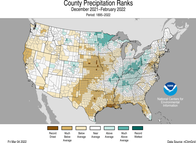
Figure 2. Accumulated Snowfall Percent of Normal (August 1, 2021–March 17, 2022)
Impacts
- Soils are very dry from the Central Plains through portions of Iowa and Missouri. Soil moisture in eastern Colorado, Kansas, Nebraska, and Wyoming is less than the 5th percentile (Figure 3).
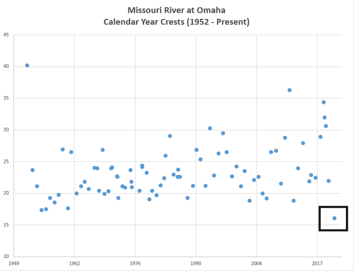
- Streamflow on the Missouri River is historically low. The highest stage recorded on the Missouri River at Omaha, Nebraska in 2021 was the lowest annual peak since 1952 (Figure 4).
- Drought conditions have reduced the Missouri River Mainstem Reservoir System storage. As a result, drought conservation measures such as minimum winter releases of 12,000 cfs were implemented. Based on the March 15 System storage check, navigation flow support will be at minimum service to start the 2022 navigation season, which means an 8-foot deep navigation channel instead of a 9-foot deep navigation channel under full service flow support.
- The lack of precipitation and overall moisture has led to increased wildland fires in Kansas, Nebraska, and South Dakota. The Cottonwood Complex Fire near Hutchinson, Kansas in early March led to one fatality, destroyed 35 homes and 110 vehicles, and burned 12,000 acres.
- There are concerns of potentially toxic levels of total dissolved solids (TDS) in surface water for livestock in North Dakota after two years of drought. In South Dakota and Nebraska, there are major concerns about feed and water supply this spring and summer for livestock.
- In agriculture, the dry conditions have inhibited growth of and damaged winter wheat and cover crops in Colorado, Kansas, Nebraska, and South Dakota.
Report your drought impacts through the Condition Monitoring Observer Reports (CMOR):
Figure 3. Past Month Top 1-Meter Soil Moisture Percentile (Valid March 13, 2022)
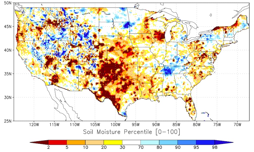
Figure 4: Streamflow Peak Values on the Missouri River at Omaha (1952–Present)
Outlooks and Potential Impacts
- The Missouri River Basin needs periodic and regular above-average precipitation in order to avoid further drought deterioration. While spring is typically the wettest time of the year for the basin, the April through June precipitation outlook is leaning towards drier-than-normal conditions for a majority of the basin (Figure 5). The April–June temperature outlook is leaning towards warmer-than-normal conditions as well, which could exacerbate the issues by removing additional moisture from the ground.
- This increased potential for drier and warmer conditions will likely lead to drought persistence and potentially intensification across the entire basin, with the potential for drought development in eastern Kansas (Figure 6).
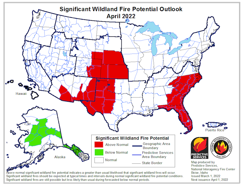
- The Significant Wildland Fire Potential Outlook for April 2022 shows above-normal chances for significant wildland fire across eastern Colorado, Kansas, Nebraska, and southeast Wyoming (Figure 7). These conditions will likely last until vegetation begins to grow, and/or precipitation falls.
- Other potential spring and summer impacts include limited water supply for agriculture and livestock, crop damage and loss, water quality issues, limitations to water supply and navigation along the Missouri River and its tributaries, and recreation impacts from low water at marinas and boat launches.
Figure 5. Seasonal Precipitation Outlook for April–June 2022
Figure 6. U.S. Seasonal Drought Outlook for March 17–June 30, 2022
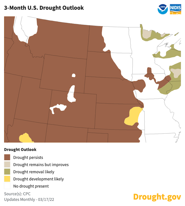
Figure 7. Significant Wildland Fire Potential Outlook for April 2022
For More Information
- NIDIS and its partners will issue future updates as conditions evolve.
- This drought status update is based on information provided in the March 17th North Central Climate and Drought Outlook Webinar (view recording for more details), as well as the NOAA Climate Prediction Center Spring 2022 Outlook.
- A special thank you to the state climate offices in the Missouri River Basin for providing local information on drought conditions and impacts included in the webinar and on this report.
- More local information is available from the following resources:
- To report or view local drought impact information:
- Report your drought impacts through Condition Monitoring Observer Reports (CMOR).
- To view or submit reports in Montana, visit the Montana Drought Impact Reporter.
- View CoCoRaHS Condition Monitoring reports.
- The upcoming North Central U.S. Climate and Drought Summary & Outlook Webinars on April 21, 2022 will offer updated information about conditions, impacts, and outlooks.
Prepared By
Molly Woloszyn & Britt Parker
NOAA/National Integrated Drought Information System (NIDIS), CIRES/CU Boulder
Doug Kluck
NOAA/National Centers for Environmental Information
Dennis Todey
USDA Midwest Climate Hub
Trent Ford (Webinar Presenter)
University of Illinois-Illinois State Water Survey
This drought status update is issued in partnership between the National Oceanic and Atmospheric Administration (NOAA) and the U.S. Department of Agriculture (USDA) to communicate a potential area of concern for drought expansion and/or development within the Missouri River Basin based on recent conditions and the upcoming forecast. NIDIS and its partners will issue future drought status updates as conditions evolve.


