Drought Likely to Persist and Potentially Expand in Summer
Key Points
- Drought continues across the Missouri River Basin, with moderate to extreme drought (D1–D3) impacting Colorado, Kansas, Montana, Nebraska, North Dakota, South Dakota, and Wyoming.
- Drought intensification has been most significant this past month across the Central Plains of Kansas, Nebraska, and South Dakota, where the U.S. Drought Monitor has worsened by one or two categories.
- The wind speeds have been stronger than normal this spring, and this, combined with the dry conditions, has resulted in significant and continuous wildfire issues across Kansas, Nebraska, and South Dakota.
- Other drought impacts include poor to very poor winter wheat conditions, limited water availability for livestock, poor rangeland conditions, and below-normal inflow on the mainstem of the Missouri River, resulting in the implementation of water conservation measures by the U.S. Army Corps of Engineers.
- Despite potential for short-term relief in some areas, seasonal outlooks are calling for above-normal temperatures and below-normal precipitation for May through July across a majority of the Missouri River Basin. As a result, drought is likely to persist across existing areas, and will likely expand further east into western portions of Iowa, Minnesota, and Missouri.
- Current drought impacts are likely to persist, and potentially intensify, over the coming months. This includes elevated wildfire risk, limited water availability and feed for livestock, inadequate moisture for crop growth, and continuation of water conservation efforts along the Missouri River and tributaries.
Current U.S. Drought Monitor map for the Missouri River Basin Drought Early Warning System (DEWS) region with data valid for April 26, 2022. The U.S. Drought Monitor (USDM) is updated each Thursday to show the location and intensity of drought across the country. Drought categories show experts’ assessments of conditions related to dryness and drought including observations of how much water is available in streams, lakes, and soils compared to usual for the same time of year.
U.S. Drought Monitor Categories
Current U.S. Drought Monitor map for the Missouri River Basin Drought Early Warning System (DEWS) region with data valid for April 26, 2022. The U.S. Drought Monitor (USDM) is updated each Thursday to show the location and intensity of drought across the country. Drought categories show experts’ assessments of conditions related to dryness and drought including observations of how much water is available in streams, lakes, and soils compared to usual for the same time of year.
Current Conditions
- Drought continues across the Missouri River Basin, with moderate to extreme drought (D1–D3) impacting Colorado, Kansas, Montana, Nebraska, North Dakota, South Dakota, and Wyoming. Extreme drought (D3) currently covers 39% of Montana, 22% of Nebraska, 20% of Kansas, 18% of Wyoming, and 4% of South Dakota and Colorado.
- Since March 1, drought intensification has been most significant in the Central Plains across Kansas, Nebraska, and South Dakota where the U.S. Drought Monitor has worsened by one or two categories (Figure 1).
- The worsening conditions recently have been driven by below-normal precipitation across eastern Colorado, Kansas, Nebraska, and southern South Dakota over the last 30 days, exacerbating existing dry conditions. In these areas, precipitation has ranged from only 5%–50% of normal (Figure 2). Overall, temperatures have been near- to below-normal across the basin over the last 30 days.
- A major winter storm the week of April 11 brought significant snowfall to North Dakota and portions of Montana. In North Dakota, there was enough moisture to help alleviate some drought issues, but this was not the case in Montana. However, Montana has received some precipitation this past week that has improved conditions. Cooler temperatures have also kept drought from worsening in many areas as well.
- Soil moisture is significantly below normal across Nebraska and Kansas, as well as portions of Colorado, Montana, and Wyoming (Figure 3). Limited soil moisture has contributed to poor winter wheat condition and increased the occurrence of wildfires. In addition, some farmers are waiting to plant because the soil is too dry, and some are irrigating to wet the soils enough in order to plant.
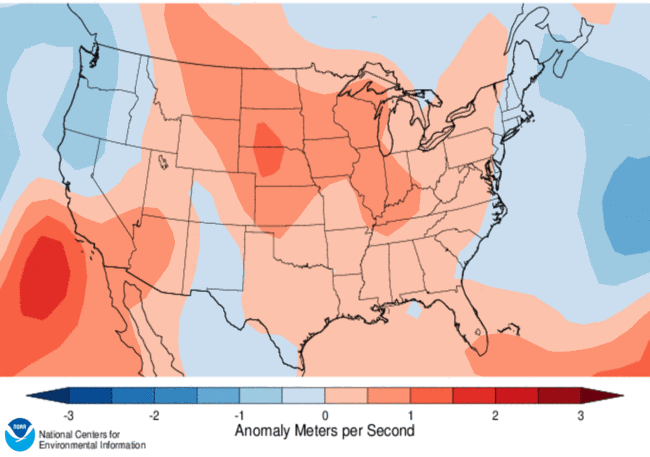
- Wind speeds have been unusually high recently as well, which has led to increased wildfire issues. Winds are typically stronger in the spring compared to other times of the year, but the central U.S. experienced winds in March that were well above normal (Figure 4).
Figure 1. U.S. Drought Monitor Change Map Since March 1, 2022
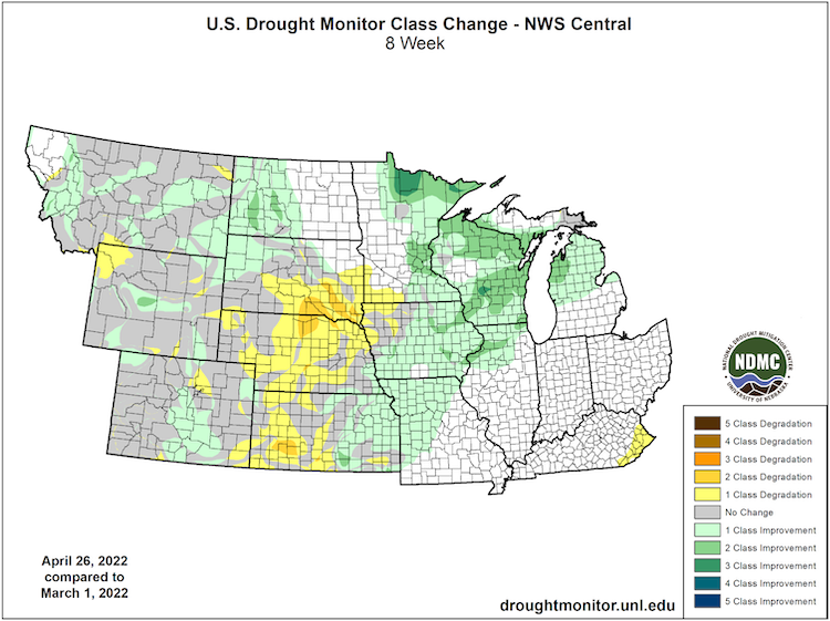
Figure 2. Percent of Normal Precipitation (March 29–April 27, 2022)
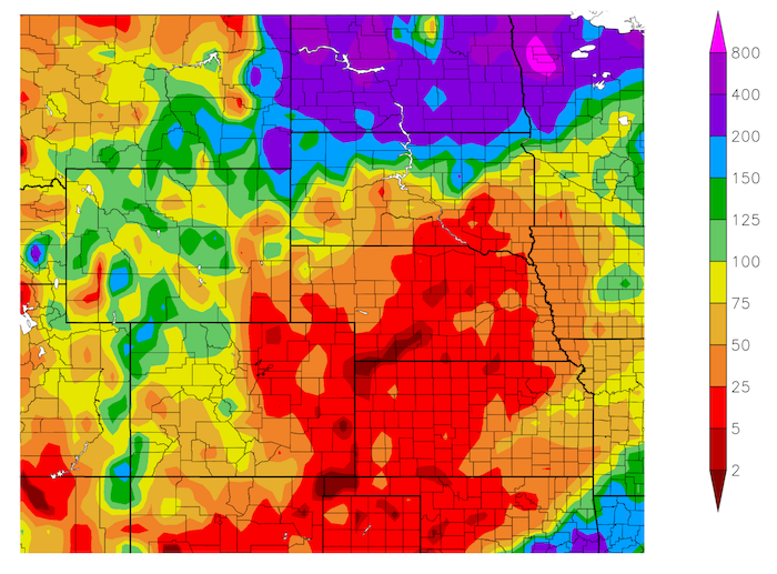
Figure 3. Past Month Top 1-Meter Soil Moisture Percentile (Valid April 23, 2022)
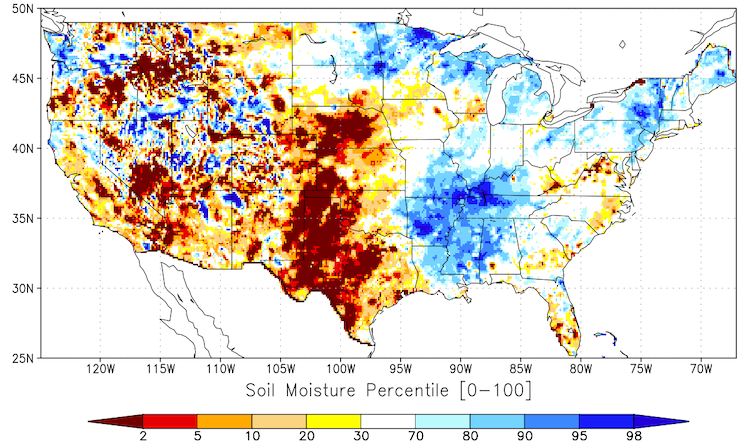
Figure 4. 10-Meter Wind Speed Anomaly for March 2022
Impacts
- Reservoir inflows in the Missouri River Basin above Sioux City, Iowa were well-below average in March due to dry soil conditions and well-below normal precipitation across the basin. As a result, the U.S. Army Corps of Engineers are implementing water conservation measures, such as minimum water releases and reduced flow support for navigation.
- The dry and windy conditions have led to numerous destructive, and some fatal, wildfires across the Central Plains, particularly across Kansas, Nebraska, and South Dakota. Fires in southwest Nebraska in early April resulted in two deaths, numerous firefighter injuries, and the destruction of several dozen homes or structures.
- A “Fuels and Fire Behavior Advisory” was issued on April 11 for central Kansas and Nebraska, as critically dry conditions and cooler conditions have delayed green-up and have created a volatile landscape for extreme fire behavior in these areas. The advisory lasts through April 28.
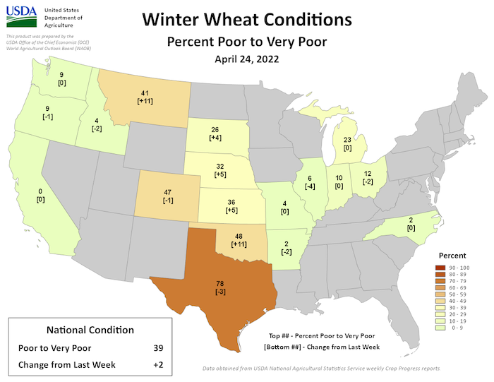
- The dry conditions have contributed to poor winter wheat conditions across the Plains states, with 47% rated poor or very poor in Colorado, 41% in Montana, 36% in Kansas, 32% in Nebraska, and 26% in South Dakota (Figure 5). Recent precipitation in Montana has helped ease concerns around winter wheat in the state, and also provided some much-needed moisture for planting.
- Water and feed for livestock are extremely limited across the region. In Wyoming, springs and ponds are drying up, and livestock are traveling a mile or two in order to find water. Similar issues are being felt across Kansas, Montana, Nebraska, and South Dakota as well. Grasses and forage for livestock will not grow well without moisture, and widespread drought will limit overall access to hay. According to a reporter in Weston County, Wyoming, these are the worst range conditions in over 55 years of livestock production.
- Residents in Omaha, Lincoln, and Fremont, Nebraska are being encouraged to conserve water as drought persists in their area, affecting the flow of the Platte River.
Report your drought impacts through the Condition Monitoring Observer Reports (CMOR):
Figure 5. Winter Wheat Conditions (As of April 24, 2022)
Outlook and Potential Impacts
- The short-term precipitation outlook from NOAA for May 5–11 shows the potential for above-normal precipitation across northern portions of the basin, with near-normal precipitation elsewhere (Figure 6).
- NOAA is also forecasting a slight risk for high winds across the central Plains from May 5–8, which will likely increase the risk for wildfire during this time; however, the potential for near-normal precipitation could help alleviate some concerns.
- Moving into May, outlooks are not optimistic for portions of the Central Plains, particularly across Colorado, Kansas, and Nebraska. Precipitation is likely to be below-normal across Colorado, Kansas, and Nebraska, with a greater chance for above-normal temperatures as well. In contrast, there are greater chances for above-normal precipitation in eastern Montana and North Dakota, which could bring some relief for these areas (Figure 7).
- The seasonal precipitation and temperature outlooks for May through July 2022 show a greater chance for drier and hotter conditions across much of the Missouri River Basin. As a result, the 3-month Seasonal Drought Outlook ending July 31, 2022 is forecasting drought persistence across the areas currently in drought, with potential drought development across eastern portions of Kansas, Nebraska, and South Dakota, as well as into Iowa, southern Minnesota, and northern Missouri (Figure 8).
- Despite some potential for short-term relief, a hot and dry outlook for May–July 2022 is cause for concern, particularly for those areas that have recently seen an intensification in drought conditions (Colorado, Kansas, Nebraska, and South Dakota). In addition, May and June are typically the wettest times of year for many areas in the Plains. Even if areas do get near-normal rainfall, current moisture deficits will likely overwhelm recovery efforts.
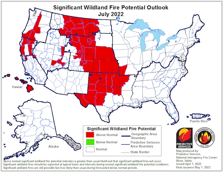
- Significant wildfire potential is expected to be above-normal throughout the summer, particularly in July across a majority of the basin (Figure 9).
- Livestock producers are particularly concerned about the upcoming season, as water and feed sources are already limited. Soil moisture is limited in many places across the basin, and the outlook for continued dry conditions will likely mean inadequate moisture for crop growth unless irrigation is used.
Figure 6. Precipitation Outlook for May 5–11, 2022
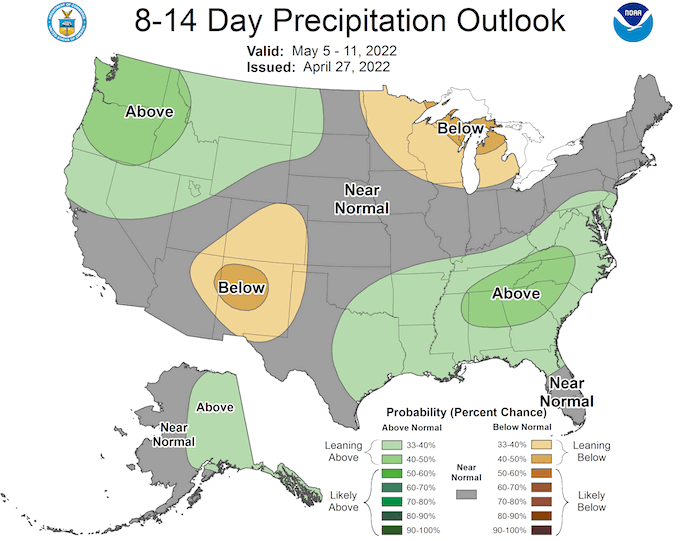
Figure 7. Monthly Precipitation Outlook for May 2022
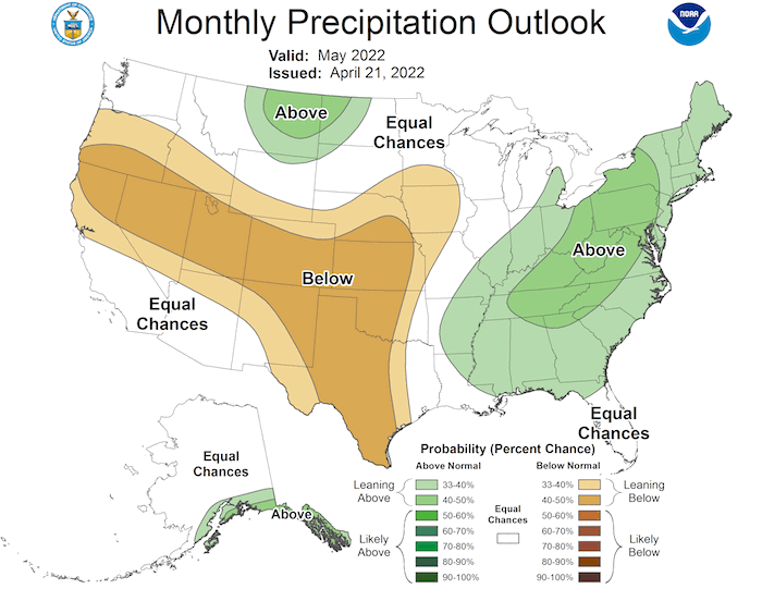
Figure 8. U.S. Seasonal Drought Outlook for April 21–July 31, 2022
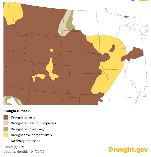
Figure 9. Significant Wildland Fire Potential Outlook for July 2022
For More Information
- NIDIS and its partners will issue future updates as conditions evolve.
- For more details on current conditions, view the April 21 North Central Climate and Drought Outlook Webinar.
- A special thank you to the state climate offices in the Missouri River Basin for providing local information on drought conditions and impacts included in the webinar and on this report.
- More local information is available from the following resources:
- To report or view local drought impact information:
- Report your drought impacts through Condition Monitoring Observer Reports (CMOR).
- To view or submit reports in Montana, visit the Montana Drought Impact Reporter.
- View CoCoRaHS Condition Monitoring reports.
- The upcoming North Central U.S. Climate and Drought Summary & Outlook Webinar on May 19, 2022 will offer updated information about conditions, impacts, and outlooks.
Prepared By
Molly Woloszyn & Britt Parker
NOAA/National Integrated Drought Information System (NIDIS), CIRES/CU Boulder
Doug Kluck
NOAA/National Centers for Environmental Information
Dannele Peck & Dennis Todey
USDA Northern Plains Climate Hub & Midwest Climate Hub
Kevin Low
NOAA/National Weather Service Missouri Basin River Forecast Center
Audra Bruschi & Ray Wolf
NOAA/National Weather Service Central Region
Rezaul Mahmood & Gannon Rush
High Plains Regional Climate Center
This drought status update is issued in partnership between the National Oceanic and Atmospheric Administration (NOAA) and the U.S. Department of Agriculture (USDA) to communicate a potential area of concern for drought expansion and/or development within the Missouri River Basin based on recent conditions and the upcoming forecast. NIDIS and its partners will issue future drought status updates as conditions evolve.


