
Southern Plains
The development of the Southern Plains Drought Early Warning System (DEWS) was initiated in 2011 when a drought of strong intensity and vast geographical extent unfolded in the southern tier of the United States. From 2010–2015, drought persisted throughout parts of the region, impacting western portions of Texas and Oklahoma and eastern New Mexico as well as many other areas in these states. Impacts were numerous across economic sectors. Failure of winter wheat and summer crops during 2011 resulted in shortages of food for cattle, which forced farmers to purchase large amounts of hay or sell their herds. Additionally, the drought caused critical municipal water shortages and led to wildfire danger and other ecological impacts. Many of these impacts lingered until 2015. The Southern Plains DEWS was launched to meet the diverse needs of stakeholders who needed information on drought conditions and the forecasted outlook, but often on different spatial and temporal scales.
Primary contact: Joel Lisonbee, Regional Drought Information Coordinator

NOAA's National Integrated Drought Information System, in partnership with the Southern Regional Climate Center conducted a post-drought assessment of the Southern Plains drought of 2020-2025 to understand the drought’s evolution and impacts (including economic costs) and communicate them to decision-makers across the region, the private sector, and the public. NIDIS is an interagency program within the Climate Program Office, which is part of NOAA's Office of Oceanic and Atmospheric Research.
Regional Activities
The following table highlights activities in the Southern Plains that are ongoing efforts related to drought, involve multiple partners, serve as a unique way to address regional drought needs, and are related to at least one of the components of drought early warning. Please contact Joel Lisonbee (joel.lisonbee@noaa.gov) for more information about the table or to inquire about getting an activity added to the list.
DEWS Component Legend
To improve access and usability of drought and water information across the Mississippi River Basin, NOAA, in partnership with the U.S. Army Corps of Engineers, is developing a…
2024
2025
The Great Plains and California consist of the first and second largest economies in the U.S., but both regions are prone to extreme droughts. Yet, it is…
2020
2023
Inspired by missions to connect, America’s Watershed Initiative, in partnership with The Nature Conservancy, has engaged dozens of government, community, industry, and non-governmental…
National Weather Service drought information statements provide up-to-date reports on the current drought situation for a Weather Forecast Office’s (WFO's) county warning and forecast area. These…
The USDA-NIFA funded Ogallala Water Coordinated Agriculture Project involves around 70 researchers engaged in interdisciplinary, collaborative research and outreach related to dryland,…
2016
2021
Observation + Monitoring
The Southern Plains DEWS contains diverse climates such as the semi-arid region of the Texas and Oklahoma panhandles and western Kansas, the desert in eastern New Mexico and Big Bend Country of western Texas, and the hot, humid subtropical Gulf Coast. Weather across the region can change quickly; the region is prone to severe thunderstorms, tornadoes, and hurricanes in the summer and snow and occasional blizzards in the winter. The region is also prone to regular drought. When monitoring drought in the Southern Plains, it is important to consider precipitation, temperature, and evaporation together as water can quickly leave the landscape during times of high evaporative demand. Other indicators include streamflow, soil moisture, groundwater, and various derived indices for monitoring drought in the region.
Regional Data and Maps
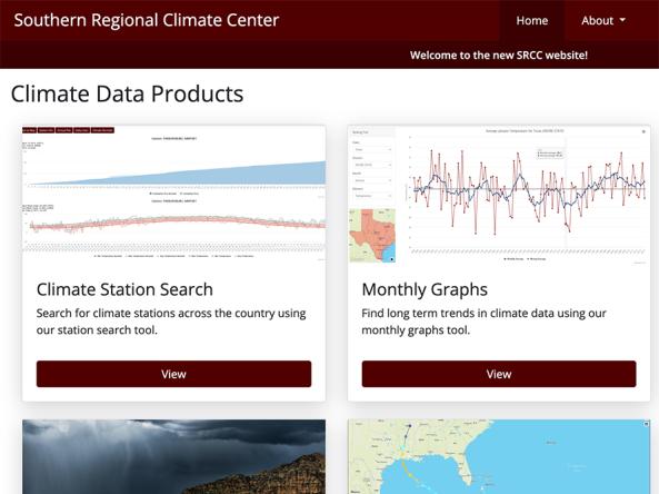
The Southern Regional Climate Center Dashboard provides climate data products for the Southern U.S., including Arkansas, Louisiana, Mississippi, Oklahoma, Tennessee, and Texas.
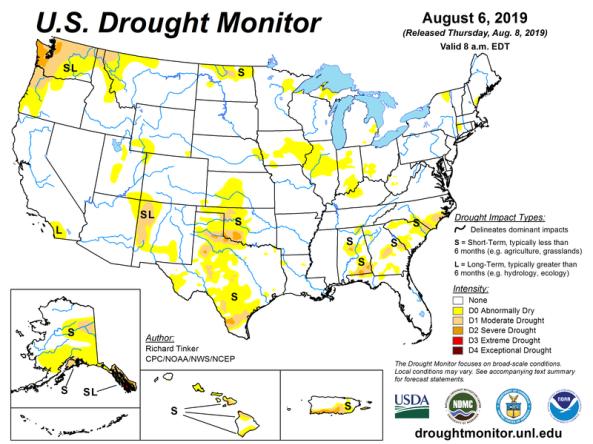
The U.S. Drought Monitor is a map updated each Thursday to show the location and intensity of drought across the country.
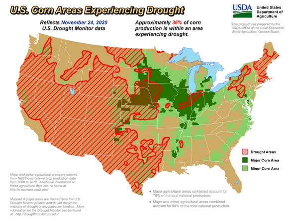
The U.S. Department of Agriculture produces weekly maps and charts displaying locations and percentages of drought-affected areas corn, soybeans, hay, cattle, and winter wheat.
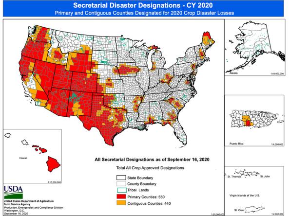
Maps displaying counties declared primary (red) or contiguous (orange) disaster counties by the Secretary of Agriculture.
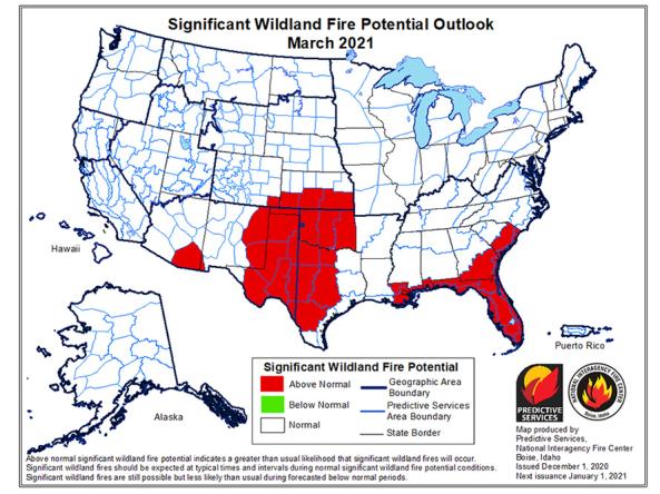
The National Significant Wildland Fire Potential Outlook is intended as a decision support tool for wildland fire managers, providing an assessment of current weather and fuels condition
This tool, available as part of The Climate Toolbox, provides maps and summary tables of different drought types, such as agricultural and meteorological drought, for a location in the contiguous U
Planning + Preparedness
The states of the Southern Plains region all have plans for responding to drought. These have been produced by the state agencies responsible for the states' drought response and are linked on this page. For other groups within the region (counties, cities, or industry groups) that would like to create their own drought plan, we have included links to resources on this page. Or, contact the Regional DEWS Coordinator, Joel Lisonbee, for some ideas on how to get started.
Regional Drought Planning Resources


Prediction + Forecasting
While droughts can occur during any time of the year, those that coincide with crop cycles can be especially costly for the Southern Plains region. The resources provided here, while not specific to the region, can provide some indication of when a drought may start and when it may end.
Regional Forecasts and Outlooks
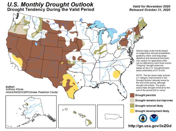
The U.S. Monthly Drought Outlook predicts whether drought will emerge, stay the same or get better over the next 30 days or so.
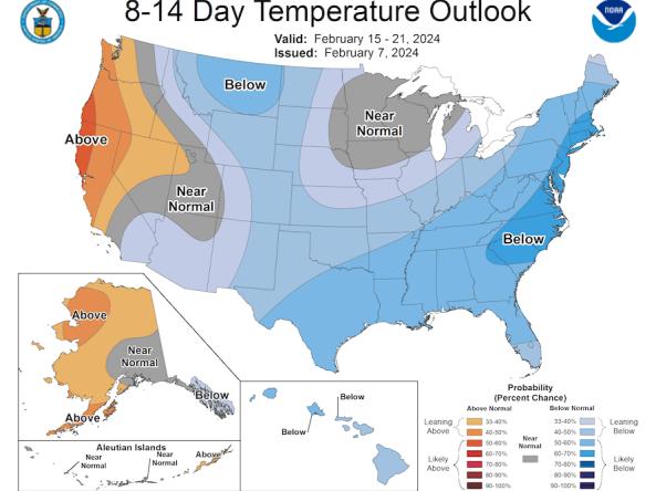
The Climate Prediction Center (CPC) produces temperature and precipitation outlooks for the U.S., including 6-10 day, 8-14 day, monthly, and seasonal outlooks.
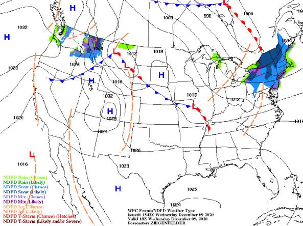
NWS provides a wide selection of forecast maps for temperature and precipitation for the next 12 hours to 6 days.
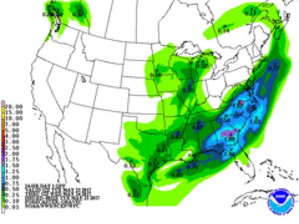
NWS WPC produces Quantitative Precipitation Forecasts (QPFs) that depict the amount of liquid precipitation expected to fall in a defined period of time.
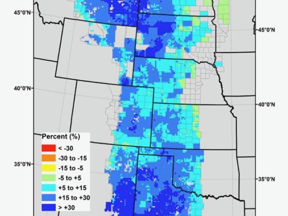
Grass-Cast indicates for ranchers and rangeland managers what productivity is likely to be in the upcoming growing season relative to their own county’s 34-year history.
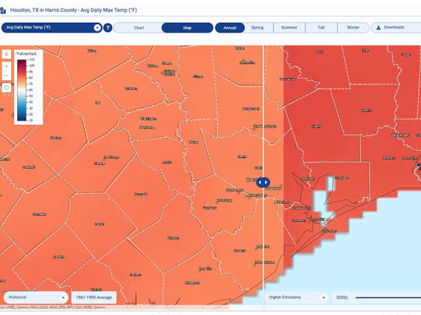
The Climate Explorer offers graphs and maps of observed and projected temperature, precipitation, and related climate variables for every county in the contiguous United States, helping people asse
Communication + Outreach
NIDIS’s mission for the Southern Plains includes providing those affected by drought with the best available information and resources to better prepare for, mitigate, and respond to the effects of drought. This includes communication and outreach by NIDIS and our partners within the Drought Early Warning network.
For example, regional drought status updates communicate a potential area of concern for drought expansion and/or development in the Southern Plains, based on recent conditions and the upcoming forecast.
The resources below highlight upcoming events or communications tools (podcasts, videos, social media) that are relevant to the Southern Plains. Did we miss something? Let us know by contacting the Regional DEWS Coordinator.
Regional Communications Documents


Research + Applications
The Southern Plains DEWS region has a strong research presence, which includes seven land grant universities within the region and several more in surrounding states, as well as the Southern Climate Impacts Planning Program (SCIPP, a NOAA RISA team).