Historically High Snow Levels in the Sierra Nevada and Great Basin; Snow Drought for Parts of the Pacific Northwest
Key Points
- Early April is the typical period of peak snow water equivalent (SWE) in the West, and April 1 SWE is one of the initial indicators of potential spring and summer water supply.
- Serious drought concerns remain in parts of the Pacific Northwest in part due to lack of snow, while record-high SWE in California, Nevada, Utah, and western Colorado means spring and summer flooding potential.
- According to the U.S. Bureau of Reclamation’s reservoir level projections, Lake Powell will rise significantly by summer, whereas Lake Mead may continue to fall. Both reservoirs will still be at critically low levels by the end of the year given more than 20 years of drought.
Snow Telemetry (SNOTEL) snow water equivalent (SWE) values for watersheds in the western U.S. as a percentage of the 1991–2020 median recorded by the USDA Natural Resources Conservation Service (NRCS). Only stations with at least 20 years of data are included in the station averages.
The SWE percent of normal, in this figure and in the text, represents the current SWE at selected SNOTEL stations in or near the basin compared to the median value for those stations on the same date from 1991–2020. This map is valid as of April 3, 2023.
For an interactive version of this map, please visit NRCS.
Snow Telemetry (SNOTEL) snow water equivalent (SWE) values for watersheds in Alaska as a percentage of the 1991–2020 median recorded by the USDA Natural Resources Conservation Service (NRCS). Only stations with at least 20 years of data are included in the station averages.
The SWE percent of normal, in this figure and in the text, represents the current SWE at selected SNOTEL stations in or near the basin compared to the median value for those stations on the same date. This map is valid as of April 3, 2023.
For an interactive version of this map, please visit NRCS.
Percent of Median Snow Water Equivalent
< 50% of Median
Current snow water equivalent (SWE) is less than 50% of the median SWE value for this day of the year, compared to historical conditions from 1991–2020.
50%–70% of Median
Current snow water equivalent (SWE) is between 50%–70% of the median SWE value for this day of the year, compared to historical conditions from 1991–2020.
70%–90% of Median
Current snow water equivalent (SWE) is between 70%–90% of the median SWE value for this day of the year, compared to historical conditions from 1991–2020.
90%–110% of Median
Current snow water equivalent (SWE) is between 90%–110% of the median SWE value for this day of the year, compared to historical conditions from 1991–2020.
110%–130% of Median
Current snow water equivalent (SWE) is between 110%–130% of the median SWE value for this day of the year, compared to historical conditions from 1991–2020.
130%–150% of Median
Current snow water equivalent (SWE) is between 130%–150% of the median SWE value for this day of the year, compared to historical conditions from 1991–2020.
>150% of Median
Current snow water equivalent (SWE) is greater than 150% of the median SWE value for this day of the year, compared to historical conditions from 1991–2020.
Snow Telemetry (SNOTEL) snow water equivalent (SWE) values for watersheds in the western U.S. as a percentage of the 1991–2020 median recorded by the USDA Natural Resources Conservation Service (NRCS). Only stations with at least 20 years of data are included in the station averages.
The SWE percent of normal, in this figure and in the text, represents the current SWE at selected SNOTEL stations in or near the basin compared to the median value for those stations on the same date from 1991–2020. This map is valid as of April 3, 2023.
For an interactive version of this map, please visit NRCS.
Snow Telemetry (SNOTEL) snow water equivalent (SWE) values for watersheds in Alaska as a percentage of the 1991–2020 median recorded by the USDA Natural Resources Conservation Service (NRCS). Only stations with at least 20 years of data are included in the station averages.
The SWE percent of normal, in this figure and in the text, represents the current SWE at selected SNOTEL stations in or near the basin compared to the median value for those stations on the same date. This map is valid as of April 3, 2023.
For an interactive version of this map, please visit NRCS.
Snowpack continued to grow throughout March across most of the West, with cold temperatures limiting any major early snowmelt. Early April is the typical period of peak snow water equivalent (SWE) in the West, and April 1 SWE is one of the initial indicators of potential spring and summer water supply. Snow drought concerns are geographically limited, but serious in those regions. Across most of the West, by contrast, the greater concern is spring and summer flood potential due to extremely high, and in some locations record high, SWE throughout California, Nevada, Utah, and western Colorado.
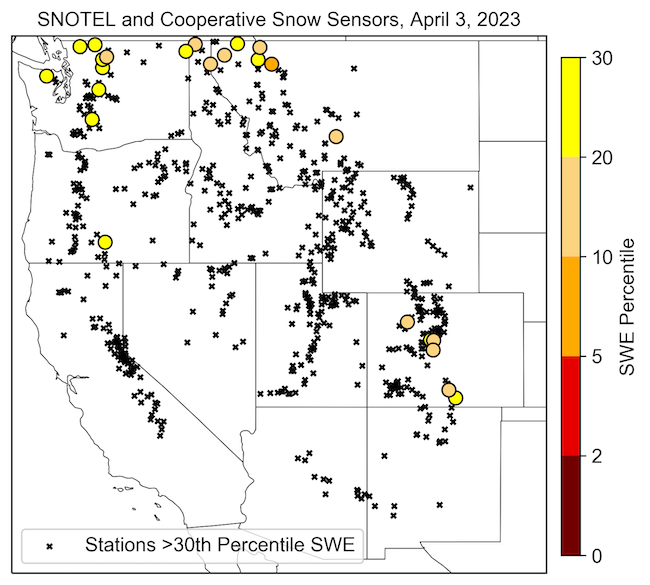
Rain and snow in northern Washington, northern Idaho, and northwestern Montana were far below normal in March, and snow drought concerns remain in these areas. SWE at a handful of SNOTEL sites in this region is currently below the 20th percentile. SWE in the Kootenai Basin, which straddles the U.S.–-Canada border and includes the northern tip of Idaho and far- northwestern Montana, is currently at 81% of normal. While SWE has improved across Oregon, soil moisture and streamflow deficits persist. In central Oregon, drought conditions have been in place for several years, and four counties already have 2023 drought declarations.
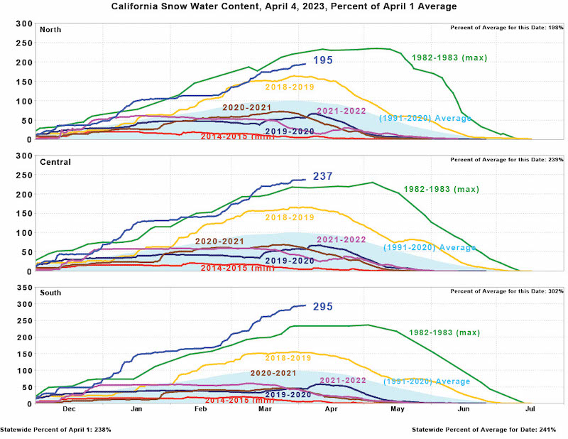
Outside of the Pacific Northwest, this winter’s snowpack has become historic across much of the West. About 30% of all western SNOTEL and California Department of Water Resources snow pillow sites set new record-high SWE for early April. In the central and southern Sierra Nevada, the long-term snow survey data from April 1 indicate that the 2023 snowpack is the deepest in the past 90 years, greater than previous benchmark years of 1952, 1969, 1983, and 2017—and in some cases by a large margin. The Mammoth Pass, California, April 1 snow survey recorded 104.5 inches of SWE, which shattered the previous record of 86.5 inches from 1969. In Utah, Alta Ski Area has recorded 834 inches of snowfall this season, breaking the previous high during the period of record (1980 to present at this site) of 748 inches during the winter of 1982–1983.
SWE at many SNOTEL sites in the Upper Colorado River Basin is also at record-high levels for this time of year. SNOTEL basin-average SWE is currently at 160% of normal and the highest on record for the date. This will alleviate much of the stress on the water supply system. On April 1, the seasonal water supply forecast projected 177% of normal April–July inflows into Lake Powell. According to the U.S. Bureau of Reclamation’s reservoir level projections, Lake Powell will rise significantly by summer. Lake Mead’s level is anticipated to fall, driven by the schedule for planned releases from Lake Powell. However, both reservoirs will still be at critically low levels by the end of the year. Several wet winters in a row are needed to make a major dent in the water supply shortage across the Colorado River Basin.
SNOTEL sites and April 1 snow survey data indicate above-normal snowpack at most locations in Alaska, with little snow drought concern. SWE in the Copper River Basin currently is 130% of normal, and snow survey data continue to indicate record or near-record snowpack. SWE at a few sites in the east end of the Turnagain Arm is below normal (70%–78%), although this pattern is restricted to a small area and snowpack in the surrounding region is above normal.
Stations with SWE Below the 30th Percentile
California Snow Water Content
* Quantifying snow drought values is an ongoing research effort. Here we have used the 30th percentile as a starting point based on partner expertise and research. Get more information on the current definition of snow drought here.
For More Information, Please Contact:
Daniel McEvoy
Western Regional Climate Center
Daniel.McEvoy@dri.edu
Amanda Sheffield
NOAA/NIDIS California-Nevada Regional Drought Information Coordinator
Amanda.Sheffield@noaa.gov
Britt Parker
NOAA/NIDIS Pacific Northwest Regional Drought Information Coordinator
Britt.Parker@noaa.gov
NIDIS and its partners launched this snow drought effort in 2018 to provide data, maps, and tools for monitoring snow drought and its impacts as well as communicating the status of snow drought across the United States, including Alaska. Thank you to our partners for your continued support of this effort and review of these updates. If you would like to report snow drought impacts, please use the link below. Information collected will be shared with the states affected to help us better understand the short term, long term, and cumulative impacts of snow drought to the citizens and the economy of the regions reliant on snowpack.
Report Your Snow Drought Impacts
Data and Maps | Snow Drought
Research and Learn | Snow Drought

