Rapid Snowmelt in the Pacific Northwest Contrasts with a Slow Melt of the Record Snowpack in the Rest of the West
Key Points
- Western U.S. snowmelt season has finally started, but record-setting snowpacks mean substantial snowpack remains.
- There is concern for drought development in some parts of the Pacific Northwest given a less impressive snowpack and a recent, rapid snowmelt event. An upcoming early season heat wave is projected to accelerate snowmelt rates.
- Snowmelt season in Alaska is slowly getting underway.
Snow Telemetry (SNOTEL) snow water equivalent (SWE) values for watersheds in the western U.S. as a percentage of the 1991–2020 median recorded by the USDA Natural Resources Conservation Service (NRCS). Only stations with at least 20 years of data are included in the station averages.
The SWE percent of normal, in this figure and in the text, represents the current SWE at selected SNOTEL stations in or near the basin compared to the median value for those stations on the same date from 1991–2020. This map is valid as of May 8, 2023.
For an interactive version of this map, please visit NRCS.
Snow Telemetry (SNOTEL) and snow course snow water equivalent (SWE) values for watersheds in Alaska as a percentage of the 1991–2020 median recorded by the USDA Natural Resources Conservation Service (NRCS). Only stations with at least 20 years of data are included in the station averages.
The SWE percentage of normal, in this figure and in the text, represents the current SWE at selected SNOTEL stations in or near the basin compared to the median value for those stations on the same date. This map is valid at of the end of April 2023.
For an interactive version of this map, please visit NRCS.
Percent of Median Snow Water Equivalent
< 50% of Median
Current snow water equivalent (SWE) is less than 50% of the median SWE value for this day of the year, compared to historical conditions from 1991–2020.
50%–70% of Median
Current snow water equivalent (SWE) is between 50%–70% of the median SWE value for this day of the year, compared to historical conditions from 1991–2020.
70%–90% of Median
Current snow water equivalent (SWE) is between 70%–90% of the median SWE value for this day of the year, compared to historical conditions from 1991–2020.
90%–110% of Median
Current snow water equivalent (SWE) is between 90%–110% of the median SWE value for this day of the year, compared to historical conditions from 1991–2020.
110%–130% of Median
Current snow water equivalent (SWE) is between 110%–130% of the median SWE value for this day of the year, compared to historical conditions from 1991–2020.
130%–150% of Median
Current snow water equivalent (SWE) is between 130%–150% of the median SWE value for this day of the year, compared to historical conditions from 1991–2020.
>150% of Median
Current snow water equivalent (SWE) is greater than 150% of the median SWE value for this day of the year, compared to historical conditions from 1991–2020.
Snow Telemetry (SNOTEL) snow water equivalent (SWE) values for watersheds in the western U.S. as a percentage of the 1991–2020 median recorded by the USDA Natural Resources Conservation Service (NRCS). Only stations with at least 20 years of data are included in the station averages.
The SWE percent of normal, in this figure and in the text, represents the current SWE at selected SNOTEL stations in or near the basin compared to the median value for those stations on the same date from 1991–2020. This map is valid as of May 8, 2023.
For an interactive version of this map, please visit NRCS.
Snow Telemetry (SNOTEL) and snow course snow water equivalent (SWE) values for watersheds in Alaska as a percentage of the 1991–2020 median recorded by the USDA Natural Resources Conservation Service (NRCS). Only stations with at least 20 years of data are included in the station averages.
The SWE percentage of normal, in this figure and in the text, represents the current SWE at selected SNOTEL stations in or near the basin compared to the median value for those stations on the same date. This map is valid at of the end of April 2023.
For an interactive version of this map, please visit NRCS.
An updated, interactive version of this map is available through the USDA's Natural Resources Conservation Service.
An updated, interactive version of this map is available through the USDA's Natural Resources Conservation Service.
Snow accumulation season has largely transitioned to snowmelt season across the West, with substantial melting observed since mid-April in some areas. Even with the snowmelt beginning, a deep snowpack remains across the higher elevations of California, Nevada, Utah, and parts of Colorado, where this season’s snowpack set many records. In the Sierra Nevada, many locations have three to four times the median snowpack for early May, with several months of snowmelt and potential flooding remaining.
A region of concern for potential spring drought development is the Pacific Northwest. In the northern portion of the Pacific Northwest and northern Rockies, snow water equivalent (SWE) peaked around 80%–100% of median. Well above normal temperatures combined with rain (except at the highest elevations) drove a rapid snowmelt event across this region (beginning in late April), and SWE at locations with near-normal SWE quickly dropped to well below normal. From April 25 through May 9, many stations across the Pacific Northwest reported snowmelt rates in the top 5 fastest for the period of record (NRCS). While snow melting is normal at this time of year, the rate of melt was unusual, and has the potential to accelerate drought development once the snow is gone. Over the past few days, temperatures have returned to near normal, but a major early season heat wave is forecasted, with several days of record high temperatures possible. The high temperatures will once again accelerate snowmelt rates and increase the likelihood of drought development over much of the region. In northern Idaho and western Montana, where the U.S. Drought Monitor indicates that moderate or severe drought is already present, drought conditions are likely to intensify.
In Alaska, most early May SNOTEL and snow courses indicate above normal SWE. The well-above-normal snowpack in the Copper River Basin that persisted all winter continued into May, with snow courses still indicating record high SWE. Snowmelt tends to start several weeks later in Alaska than in the western U.S., and many SNOTEL sites in Alaska suggest that the melt season is slowly getting underway. Kodiak Island in southern Alaska is an area of concern for general drought development. The Kodiak Island airport received just 42% of normal precipitation during February and March. Isolated parts of the Kenai peninsula have also been dry recently and had below-normal snowpack throughout winter, leading to potential drought development concerns.
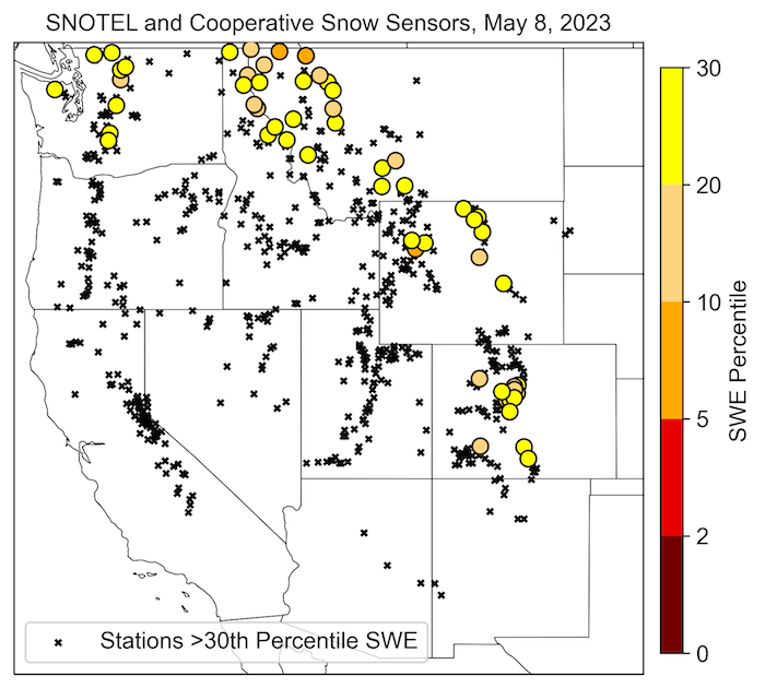
Stations with SWE Below the 30th Percentile
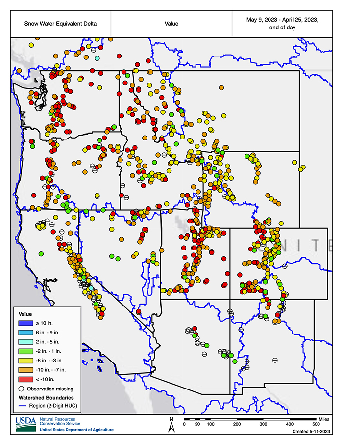
Snow Water Equivalent Change Since April 25
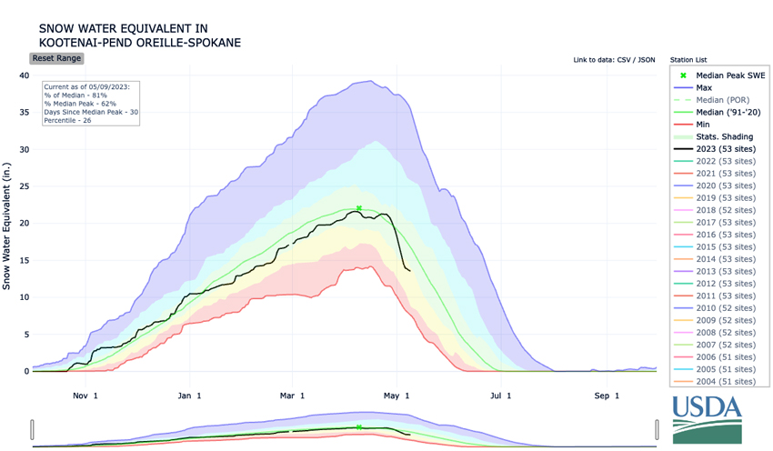
Water Year Accumulated SWE: Kootenai–Pend Oreille–Spokane Basins
* Quantifying snow drought values is an ongoing research effort. Here we have used the 30th percentile as a starting point based on partner expertise and research. Get more information on the current definition of snow drought here.
For More Information, Please Contact:
Daniel McEvoy
Western Regional Climate Center
Daniel.McEvoy@dri.edu
Amanda Sheffield
NOAA/NIDIS California-Nevada Regional Drought Information Coordinator
Amanda.Sheffield@noaa.gov
Britt Parker
NOAA/NIDIS Pacific Northwest Regional Drought Information Coordinator
Britt.Parker@noaa.gov
NIDIS and its partners launched this snow drought effort in 2018 to provide data, maps, and tools for monitoring snow drought and its impacts as well as communicating the status of snow drought across the United States, including Alaska. Thank you to our partners for your continued support of this effort and review of these updates. If you would like to report snow drought impacts, please use the link below. Information collected will be shared with the states affected to help us better understand the short term, long term, and cumulative impacts of snow drought to the citizens and the economy of the regions reliant on snowpack.
Report Your Snow Drought Impacts
Data and Maps | Snow Drought
Research and Learn | Snow Drought

