2024 Begins with Record Low Snow Conditions Across the West—But Help Is on the Way
Key Points
- In early January, snow water equivalent (SWE) observations at some SNOTEL stations in Montana, Wyoming, Idaho, Colorado, Utah, Nevada, California, Oregon, and Washington were at record low values.
- The highest concentration of record low SWE is in the northern Rocky Mountains across Montana, Wyoming, and Idaho.
- Storms over the next week will improve conditions in the Pacific Northwest, Great Basin, and northern Rockies, but are unlikely to completely erase existing deficits.
Snow Telemetry (SNOTEL) snow water equivalent (SWE) values for watersheds in the western U.S. as a percentage of the 1991–2020 median recorded by the USDA Natural Resources Conservation Service (NRCS). Only stations with at least 20 years of data are included in the station averages.
The SWE percent of normal, in this figure and in the text, represents the current SWE at selected SNOTEL stations in or near the basin compared to the median value for those stations on the same date from 1991–2020. This map is valid through the end of the day January 7, 2024.
For an interactive version of this map, please visit NRCS.
Snow Telemetry (SNOTEL) and snow course snow water equivalent (SWE) values for watersheds in Alaska as a percentage of the 1991–2020 median recorded by the USDA Natural Resources Conservation Service (NRCS). Only stations with at least 20 years of data are included in the station averages.
The SWE percentage of normal, in this figure and in the text, represents the current SWE at selected SNOTEL stations in or near the basin compared to the median value for those stations on the same date. This map is valid through the end of the day on January 7, 2024.
For an interactive version of this map, please visit NRCS.
Percent of Median Snow Water Equivalent
< 50% of Median
Current snow water equivalent (SWE) is less than 50% of the median SWE value for this day of the year, compared to historical conditions from 1991–2020.
50%–70% of Median
Current snow water equivalent (SWE) is between 50%–70% of the median SWE value for this day of the year, compared to historical conditions from 1991–2020.
70%–90% of Median
Current snow water equivalent (SWE) is between 70%–90% of the median SWE value for this day of the year, compared to historical conditions from 1991–2020.
90%–110% of Median
Current snow water equivalent (SWE) is between 90%–110% of the median SWE value for this day of the year, compared to historical conditions from 1991–2020.
110%–130% of Median
Current snow water equivalent (SWE) is between 110%–130% of the median SWE value for this day of the year, compared to historical conditions from 1991–2020.
130%–150% of Median
Current snow water equivalent (SWE) is between 130%–150% of the median SWE value for this day of the year, compared to historical conditions from 1991–2020.
>150% of Median
Current snow water equivalent (SWE) is greater than 150% of the median SWE value for this day of the year, compared to historical conditions from 1991–2020.
Snow Telemetry (SNOTEL) snow water equivalent (SWE) values for watersheds in the western U.S. as a percentage of the 1991–2020 median recorded by the USDA Natural Resources Conservation Service (NRCS). Only stations with at least 20 years of data are included in the station averages.
The SWE percent of normal, in this figure and in the text, represents the current SWE at selected SNOTEL stations in or near the basin compared to the median value for those stations on the same date from 1991–2020. This map is valid through the end of the day January 7, 2024.
For an interactive version of this map, please visit NRCS.
Snow Telemetry (SNOTEL) and snow course snow water equivalent (SWE) values for watersheds in Alaska as a percentage of the 1991–2020 median recorded by the USDA Natural Resources Conservation Service (NRCS). Only stations with at least 20 years of data are included in the station averages.
The SWE percentage of normal, in this figure and in the text, represents the current SWE at selected SNOTEL stations in or near the basin compared to the median value for those stations on the same date. This map is valid through the end of the day on January 7, 2024.
For an interactive version of this map, please visit NRCS.
An updated, interactive version of this map is available through the USDA's Natural Resources Conservation Service.
An updated, interactive version of this map is available through the USDA's Natural Resources Conservation Service.
Snow Drought Conditions Summary
Snow water equivalent (SWE) is below normal across nearly the entire western U.S. as snow drought conditions have worsened in most regions over the past month. Dry and warm conditions have caused much of this snow drought, with the most severe snow drought conditions in the Northern Rocky Mountains.
Jump to conditions for your region:
- Rocky Mountain Snow Conditions
- New Mexico and Arizona Snow Conditions
- Cascade Range Snow Conditions
- Sierra Nevada and Great Basin Snow Conditions
- Alaska Snow Conditions
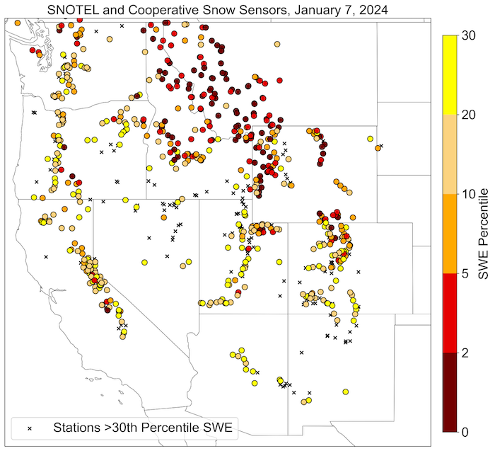
Stations with SWE Below the 30th Percentile
Key Takeaway: Snow water equivalent (SWE) is below normal across nearly the entire western U.S. because dry and warm conditions over the past month have increased the severity of snow drought conditions (defined here as SWE below the 30th percentile). The highest concentration of record low SWE is in the northern Rocky Mountains.
Rocky Mountain Snow Conditions
In the Rocky Mountains, snow drought conditions are worst in Montana, Idaho, and northern Wyoming, where SWE is generally 30%–60% of normal and at record low values at many SNOTEL stations. Very little precipitation fell over the past 30 days, and temperatures were 3–8 °F above normal. At lower-elevation stations, what little snow was present melted during the long stretch of dry and warm weather. Significant snowfall is in the forecast over the next week, which will help to improve conditions but likely will not erase the seasonal deficits.
In Utah, snow drought conditions are worst in the Uinta Mountains and the southwestern portion of the state, where SWE is generally 30%–60% of normal. In most of Colorado, SWE is generally 60%–80% of normals.
New Mexico and Arizona Snow Conditions
Snow drought conditions are fairly severe in central Arizona, with many SNOTEL stations reporting 30%–60% of normal SWE and the Lower Colorado Basin average SWE is 54% of normal. Conditions are a bit better in the Gila Mountains along the Arizona–New Mexico border, with SWE closer to normal at most stations and even above normal at a few stations. In northern New Mexico, snowpack is below normal at stations along the Colorado border but substantially greater (generally 90%–175% of normal) in the southern Sangre de Cristo Mountains and Nacimiento Mountains.
Cascade Range Snow Conditions
Snowpack is below normal across most of the Cascades with SWE generally 40%–60% of normal. The first week of December was extremely wet with multiple atmospheric rivers and 10–20 inches of rain and snow in the mountains. These storms initially boosted the snowpack; however, temperatures eventually increased and snow levels rose to well over 7,000-foot elevation, bringing heavy rain on top of the snowpack. This widespread rain-on-snow snowmelt event pushed much of the region into warm snow drought conditions, where water year precipitation was near-to-above normal, but SWE was well below normal. The remainder of December was dry leading to worsening snow drought conditions. January 4-9 brought the return to colder storms with substantial snowfall to the region. More snow is in the forecast, which should improve snow drought conditions but will not wipe out seasonal deficits.
Sierra Nevada and Great Basin Snow Conditions
Conditions in the Sierra Nevada were quite dry over the past month, with snow drought remaining firmly in place across the range. The majority of SNOTEL stations are reporting SWE values less than 50% of normal. A few small-to-moderate storms occurred over the past month, but larger atmospheric river storms with substantial moisture were absent. Additional smaller storms are forecasted over the next week, which will likely help slowly reduce seasonal deficits.
Snowpack in the Great Basin in southeast Oregon, northern Nevada, and far southern Idaho is mostly above normal. These parts of the West are among the few regions with little snow drought.
Alaska Snow Conditions
Snow drought concerns remain limited in Alaska, with nearly all SNOTEL stations reporting well-above-normal SWE for early January. It was another snowy month in south central Alaska. The Anchorage Airport received 39 inches of snowfall in December, making it the third snowiest December on record. This station also experienced its snowiest November–December on record, with 78.3 inches in those two months.. SNOTEL sites in southcentral Alaska are generally reporting 140% to over 200% of normal SWE, and in the mountains surrounding Fairbanks, SNOTEL sites are reporting 112%–158% of normal SWE. Southeast Alaska stations are reporting near-average SWE in the mountains, but little to no snow closer to sea level.
* Quantifying snow drought values is an ongoing research effort. Here we have used the 30th percentile as a starting point based on partner expertise and research. Get more information on the current definition of snow drought.
For More Information, Please Contact:
Daniel McEvoy
Western Regional Climate Center
Daniel.McEvoy@dri.edu
Amanda Sheffield
NOAA/NIDIS/CIRES California-Nevada Regional Drought Information Coordinator
Amanda.Sheffield@noaa.gov
Britt Parker
NOAA/NIDIS Pacific Northwest Regional Drought Information Coordinator
Britt.Parker@noaa.gov
Gretel Follingstad
NOAA/NIDIS/CIRES Intermountain West Regional Drought Information Coordinator
Gretel.Follingstad@noaa.gov
NIDIS and its partners launched this snow drought effort in 2018 to provide data, maps, and tools for monitoring snow drought and its impacts as well as communicating the status of snow drought across the United States, including Alaska. Thank you to our partners for your continued support of this effort and review of these updates. If you would like to report snow drought impacts, please use the link below. Information collected will be shared with the states affected to help us better understand the short term, long term, and cumulative impacts of snow drought to the citizens and the economy of the regions reliant on snowpack.
Report Your Snow Drought Impacts
Data and Maps | Snow Drought
Research and Learn | Snow Drought

