Snow Drought Expands in Parts of the Western U.S. with Early and Rapid Snowmelt
Key Points
- Western snowmelt season is well underway. Tracking snow drought during this time period helps to evaluate potential impacts to summer water supply, soil moisture, and vegetation conditions.
- The most severe snow drought remains in the northern Rocky Mountains and Washington, where the snowpack at many lower elevation sites melted one to four weeks early.
- A stretch of warm and dry weather in mid-April triggered rapid snowmelt in the Southwest, especially in southern Colorado and New Mexico.
- The NOAA National Weather Service Climate Prediction Center’s Seasonal Drought Outlook projects drought development and expansion in the above regions.
Snow Telemetry (SNOTEL) snow water equivalent (SWE) values for watersheds in the western U.S. as a percentage of the 1991–2020 median recorded by the USDA Natural Resources Conservation Service (NRCS). Only stations with at least 20 years of data are included in the station averages.
The SWE percent of median, in this figure and in the text, represents the current SWE at selected SNOTEL stations in or near the basin compared to the median value for those stations on the same date from 1991–2020. Significantly high percentages (such as in Arizona) can occur mathematically when the median is zero or near zero and are typical during snowmelt season. This map is valid through the end of the day May 5, 2024.
For an interactive version of this map, please visit NRCS.
Snow Telemetry (SNOTEL) and snow course snow water equivalent (SWE) values for watersheds in Alaska as a percentage of the 1991–2020 median recorded by the USDA Natural Resources Conservation Service (NRCS). Only stations with at least 20 years of data are included in the station averages.
The SWE percentage of median, in this figure and in the text, represents the current SWE at selected SNOTEL stations in or near the basin compared to the median value for those stations on the same date. This map is valid through the end of April 2024.
For an interactive version of this map, please visit NRCS.
Drought is defined as the lack of precipitation over an extended period of time, usually for a season or more, that results in a water shortage. Changes in precipitation can substantially disrupt crops and livestock, influence the frequency and intensity of severe weather events, and affect the quality and quantity of water available for municipal and industrial use.
Learn MoreSnow drought is a period of abnormally low snowpack for the time of year. Snowpack typically acts as a natural reservoir, providing water throughout the drier summer months. Lack of snowpack storage, or a shift in timing of snowmelt, can be a challenge for drought planning.
Learn MorePeriods of drought can lead to inadequate water supply, threatening the health, safety, and welfare of communities. Streamflow, groundwater, reservoir, and snowpack data are key to monitoring and forecasting water supply.
Learn MoreIn a drought, lower water levels or snowpack can affect the availability of recreational activities and associated tourism, and a resulting loss of revenue can severely impact supply chains and the economy. Drought—as well as negative perceptions of drought, fire bans, or wildfires—may also result in decreased visitations, cancellations in hotel stays, a reduction in booked holidays, or reduced merchandise sales.
Learn MoreDrought is defined as the lack of precipitation over an extended period of time, usually for a season or more, that results in a water shortage. Changes in precipitation can substantially disrupt crops and livestock, influence the frequency and intensity of severe weather events, and affect the quality and quantity of water available for municipal and industrial use.
Learn MoreSnow drought is a period of abnormally low snowpack for the time of year. Snowpack typically acts as a natural reservoir, providing water throughout the drier summer months. Lack of snowpack storage, or a shift in timing of snowmelt, can be a challenge for drought planning.
Learn MorePeriods of drought can lead to inadequate water supply, threatening the health, safety, and welfare of communities. Streamflow, groundwater, reservoir, and snowpack data are key to monitoring and forecasting water supply.
Learn MoreIn a drought, lower water levels or snowpack can affect the availability of recreational activities and associated tourism, and a resulting loss of revenue can severely impact supply chains and the economy. Drought—as well as negative perceptions of drought, fire bans, or wildfires—may also result in decreased visitations, cancellations in hotel stays, a reduction in booked holidays, or reduced merchandise sales.
Learn MorePercent of Median Snow Water Equivalent
< 50% of Median
Current snow water equivalent (SWE) is less than 50% of the median SWE value for this day of the year, compared to historical conditions from 1991–2020.
50%–70% of Median
Current snow water equivalent (SWE) is between 50%–70% of the median SWE value for this day of the year, compared to historical conditions from 1991–2020.
70%–90% of Median
Current snow water equivalent (SWE) is between 70%–90% of the median SWE value for this day of the year, compared to historical conditions from 1991–2020.
90%–110% of Median
Current snow water equivalent (SWE) is between 90%–110% of the median SWE value for this day of the year, compared to historical conditions from 1991–2020.
110%–130% of Median
Current snow water equivalent (SWE) is between 110%–130% of the median SWE value for this day of the year, compared to historical conditions from 1991–2020.
130%–150% of Median
Current snow water equivalent (SWE) is between 130%–150% of the median SWE value for this day of the year, compared to historical conditions from 1991–2020.
>150% of Median
Current snow water equivalent (SWE) is greater than 150% of the median SWE value for this day of the year, compared to historical conditions from 1991–2020.
Percent of Median Snow Water Equivalent
< 50% of Median
Current snow water equivalent (SWE) is less than 50% of the median SWE value for this day of the year, compared to historical conditions from 1991–2020.
50%–70% of Median
Current snow water equivalent (SWE) is between 50%–70% of the median SWE value for this day of the year, compared to historical conditions from 1991–2020.
70%–90% of Median
Current snow water equivalent (SWE) is between 70%–90% of the median SWE value for this day of the year, compared to historical conditions from 1991–2020.
90%–110% of Median
Current snow water equivalent (SWE) is between 90%–110% of the median SWE value for this day of the year, compared to historical conditions from 1991–2020.
110%–130% of Median
Current snow water equivalent (SWE) is between 110%–130% of the median SWE value for this day of the year, compared to historical conditions from 1991–2020.
130%–150% of Median
Current snow water equivalent (SWE) is between 130%–150% of the median SWE value for this day of the year, compared to historical conditions from 1991–2020.
>150% of Median
Current snow water equivalent (SWE) is greater than 150% of the median SWE value for this day of the year, compared to historical conditions from 1991–2020.
Snow Telemetry (SNOTEL) snow water equivalent (SWE) values for watersheds in the western U.S. as a percentage of the 1991–2020 median recorded by the USDA Natural Resources Conservation Service (NRCS). Only stations with at least 20 years of data are included in the station averages.
The SWE percent of median, in this figure and in the text, represents the current SWE at selected SNOTEL stations in or near the basin compared to the median value for those stations on the same date from 1991–2020. Significantly high percentages (such as in Arizona) can occur mathematically when the median is zero or near zero and are typical during snowmelt season. This map is valid through the end of the day May 5, 2024.
For an interactive version of this map, please visit NRCS.
Snow Telemetry (SNOTEL) and snow course snow water equivalent (SWE) values for watersheds in Alaska as a percentage of the 1991–2020 median recorded by the USDA Natural Resources Conservation Service (NRCS). Only stations with at least 20 years of data are included in the station averages.
The SWE percentage of median, in this figure and in the text, represents the current SWE at selected SNOTEL stations in or near the basin compared to the median value for those stations on the same date. This map is valid through the end of April 2024.
For an interactive version of this map, please visit NRCS.
An updated, interactive version of this map is available through the USDA's Natural Resources Conservation Service.
An updated, interactive version of this map is available through the USDA's Natural Resources Conservation Service.
Drought is defined as the lack of precipitation over an extended period of time, usually for a season or more, that results in a water shortage. Changes in precipitation can substantially disrupt crops and livestock, influence the frequency and intensity of severe weather events, and affect the quality and quantity of water available for municipal and industrial use.
Learn MoreSnow drought is a period of abnormally low snowpack for the time of year. Snowpack typically acts as a natural reservoir, providing water throughout the drier summer months. Lack of snowpack storage, or a shift in timing of snowmelt, can be a challenge for drought planning.
Learn MorePeriods of drought can lead to inadequate water supply, threatening the health, safety, and welfare of communities. Streamflow, groundwater, reservoir, and snowpack data are key to monitoring and forecasting water supply.
Learn MoreIn a drought, lower water levels or snowpack can affect the availability of recreational activities and associated tourism, and a resulting loss of revenue can severely impact supply chains and the economy. Drought—as well as negative perceptions of drought, fire bans, or wildfires—may also result in decreased visitations, cancellations in hotel stays, a reduction in booked holidays, or reduced merchandise sales.
Learn MoreDrought is defined as the lack of precipitation over an extended period of time, usually for a season or more, that results in a water shortage. Changes in precipitation can substantially disrupt crops and livestock, influence the frequency and intensity of severe weather events, and affect the quality and quantity of water available for municipal and industrial use.
Learn MoreSnow drought is a period of abnormally low snowpack for the time of year. Snowpack typically acts as a natural reservoir, providing water throughout the drier summer months. Lack of snowpack storage, or a shift in timing of snowmelt, can be a challenge for drought planning.
Learn MorePeriods of drought can lead to inadequate water supply, threatening the health, safety, and welfare of communities. Streamflow, groundwater, reservoir, and snowpack data are key to monitoring and forecasting water supply.
Learn MoreIn a drought, lower water levels or snowpack can affect the availability of recreational activities and associated tourism, and a resulting loss of revenue can severely impact supply chains and the economy. Drought—as well as negative perceptions of drought, fire bans, or wildfires—may also result in decreased visitations, cancellations in hotel stays, a reduction in booked holidays, or reduced merchandise sales.
Learn MoreSnow Drought Conditions Summary for May 5
This update is based on data available as of Sunday, May 5, 2024 at 12:00 a.m. We acknowledge that conditions are evolving.
Snowpack in most Western mountains has passed its peak and is melting. Tracking snow drought throughout the snowmelt season is important because snowmelt timing and rates along with snow disappearance dates can impact summer water supply, soil moisture conditions, and the likelihood of wildfires.
As of early May, the most severe snow drought conditions remain in the northern Rocky Mountains and Washington, where snowpack at many lower elevation sites melted one to four weeks early. A stretch of warm and dry weather in mid-April triggered rapid snowmelt in the Southwest. Snow water equivalent (SWE) at many locations in southwest Colorado and New Mexico fell below normal despite above-normal peak SWE earlier in the season. SWE in most of Oregon, California, and the Great Basin remain above normal.
Jump to conditions for your region:
- Rocky Mountain Snow Conditions
- New Mexico and Arizona Snow Conditions
- Cascade Range Snow Conditions
- Sierra Nevada and Great Basin Snow Conditions
- Alaska Snow Conditions
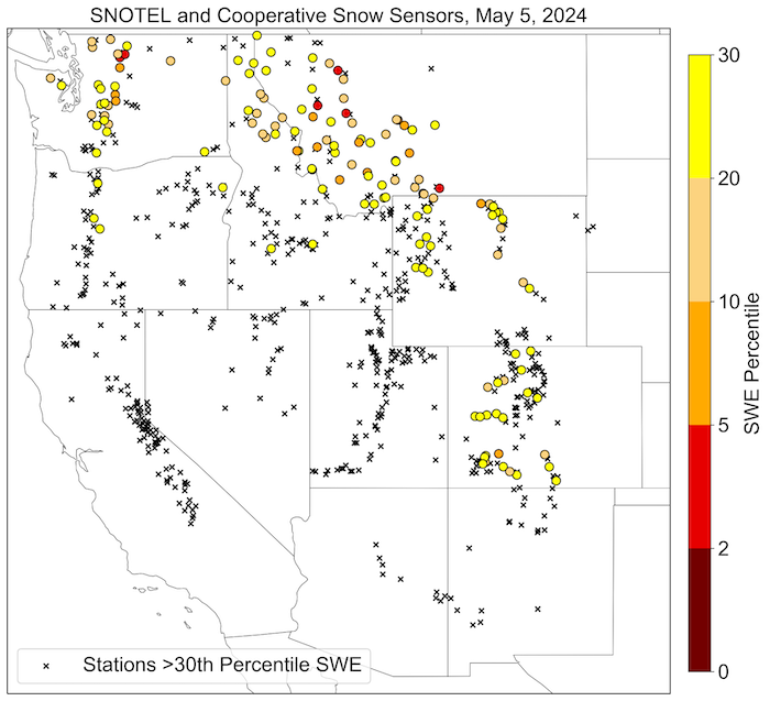
Stations with SWE Below the 30th Percentile in the Western U.S.
Key Takeaway: The western snowmelt season is well underway with the most severe snow drought continuing in the northern Rocky Mountains and Washington.
Rocky Mountain Snow Conditions
Northern Rocky Mountains
Snow drought developed early in the season in the northern Rocky Mountains and continues to persist into the spring snowmelt season. Snowpack is well below normal in northern Wyoming, western Montana, and northern Idaho with many SNOTEL stations reporting snow water equivalent (SWE) below the 20th percentile. Several storms across the region in April and early May increased SWE and delayed further melt at higher elevations. However, snow at many lower elevations melted one to four weeks earlier than normal. In Montana, snow at 24 sites has already melted, and snow at 23 of those sites melted 4 to 40 days earlier than normal. Much of this region is already in drought according to the U.S. Drought Monitor, and the persistent snow drought this season will likely increase drought severity during summer.
Central/Southern Rocky Mountains
Late season snow drought conditions developed over much of southwest Colorado despite near- to above-normal peak snow water equivalent (SWE). The Rio Grande Headwaters, Upper San Juan, and Gunnison Hydrologic Unit Code (HUC) 6 basins are currently at 45%, 65%, and 67% of normal SWE, respectively. Rapid snowmelt occurred from about April 11-25 as a result of unusually warm and dry conditions. For example, SWE in the Upper San Juan basin decreased from 107% of normal on April 11 to 68% of normal on April 25, and SWE dropped from 13.2 inches to 7.3 inches over that period. Mean temperatures during those two weeks were 5-10 degrees Fahrenheit above normal. Snow dissapearance will likely occur earlier than normal, which could decrease streamflows and runoff into the Colorado River and downstream reservoirs.
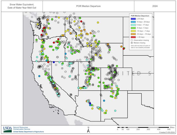
Median Departure from Normal Date of Snowmelt
Key Takeaway: As of early May, the most severe snow drought conditions continue to occur in the northern Rocky Mountains and Washington, where snow at many lower elevations melted one to four weeks early.
New Mexico and Arizona Snow Conditions
In New Mexico, snowpack at most SNOTEL stations has melted. The exceptions are a few stations in the Sangre de Cristo Mountains and one in the San Juan Mountains. The spring heat wave in this region accelerated snowmelt. Peak snow water equivalent (SWE) at most locations in this region was above normal, but the snow melted one to eight days early. Two stations in the San Pedro Mountains had well above normal peak SWE and a late snowmelt.
Similarly, in Arizona, the snowpack at most SNOTEL locations has melted. The one station with snow remaining (12 inches of SWE as of May 5) is Snowslide Canyon in the San Francisco Peaks north of Flagstaff. At this station, melt out typically occurs in early May. This year, snow at Snowslide Canyon likely will melt several weeks later than normal. Peak SWE at most SNOTEL stations in Arizona was above normal, and snow at most of these stations melted one to three weeks later than usual. The high snowpack and late snowmelt should help to improve short-term drought conditions. Retention of soil moisture later into the dry season should improve shrubland, grassland, and forest conditions.
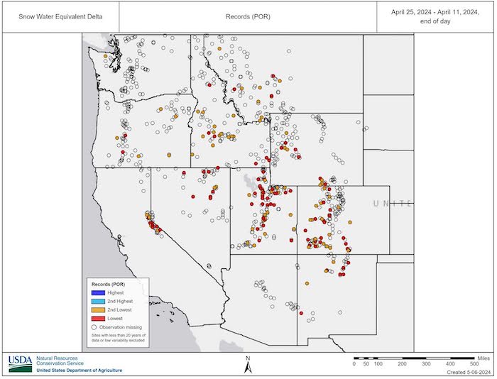
Record Changes in SNOTEL Snow Water Equivalent (SWE): April 11–25
Key Takeaway: A stretch of warm and dry weather in mid-April triggered rapid snowmelt in the Southwest. Snow water equivalent (SWE) at many locations in southwest Colorado and New Mexico fell below normal despite above-normal peaks.
Cascade Range Snow Conditions
Snow drought persists throughout most of Washington with snow water equivalent (SWE) in the Upper Columbia, Puget Sound, and Yakima basins currently at 55%, 61%, and 63% of normal, respectively. Precipitation over the past month was below normal across most of Washington and was particularly low in the central and northern Washington Cascade Range. Snow at several sites on the western slope of the Washington Cascade Range melted over a month early; however, these sites tend to have a shallow snowpack and highly variable snowmelt dates. On the eastern slope, snow melted early—four to nine days earlier than normal—at only a few sites. In mid-April, Washington declared a drought emergency for most of the state. The low snowpack was a primary driver of the drought status and declaration.
Snow drought conditions in the Oregon Cascade Range are better than in Washington, with most locations reporting near- to above-normal SWE. A series of cold storms in the last week of April brought above-normal precipitation and increased SWE across the mountain range. The SWE gains were substantial for this time of year and stopped the snowmelt that began earlier in April. Snow at some locations in the northern Oregon Cascade Range has already melted (a few days to up to 10 days early). Farther south, snow at some locations melted early, while snow cover at other locations persisted later than normal. The drought and water supply outlook is also better in the Oregon Cascade Range than in Washington, with summer runoff in most basins forecasted to be near- to above-normal.
Sierra Nevada and Great Basin Snow Conditions
Snowpack remains above normal in the Sierra Nevada mostly due to a four-day blizzard in early March followed by another snowy period during the last week of March. Following above-normal peak snow water equivalent (SWE), snowmelt began in early April, which is typical. Snowmelt rapidly accelerated to above-normal rates in mid-April. Snowmelt slowed and even stopped in some locations the first week of May, when cooler weather returned alongside a substantial snowstorm. A fast moving but powerful storm on May 4-5 resulted in maximum annual single-day snowfall in parts of the northern Sierra Nevada. For example, the Central Sierra Snow Lab received 26.4 inches of snow in 24 hours. Reservoirs in the region are full thanks to high precipitation during Water Year 2023, and summer water supply forecasts indicate above-normal runoff. Drought conditions are not anticipated this summer.
Across the Great Basin, snowpack peaked at well-above-normal levels and remains above normal. Snow melted rapidly in April, but the well-above-normal peak SWE should ensure snow across most of the region melts later than normal. Similar to the Sierra Nevada, water supply forecasts indicate above-normal summer runoff is likely throughout the Great Basin.
Alaska Snow Conditions
In South Central Alaska, most SNOTEL stations are reporting above-normal snow water equivalent (SWE), with a few sites in the Kenai Peninsula at 80%–90% of normal SWE. In the mountains outside of Fairbanks, Mt. Ryan and Munson Ridge SNOTEL sites are currently at 125% and 87% of normal SWE, respectively. Snow at several other sites in the Fairbanks area has already melted. In the Panhandle, the May 1 snow course at Petersburg Ridge S. reported 12.3 inches of SWE, just 56% of normal. Further north, available data indicate that early May SWE was near normal in the mountains east of Juneau, and on Douglas Island just to the west of Juneau, Cropley Lake and Eagle Crest snow courses reported 87% and 81% of normal SWE, respectively.
* Quantifying snow drought values is an ongoing research effort. Here we have used the 30th percentile as a starting point based on partner expertise and research. Get more information on the current definition of snow drought.
For More Information, Please Contact:
Daniel McEvoy
Western Regional Climate Center
Daniel.McEvoy@dri.edu
Amanda Sheffield
CIRES/NOAA/NIDIS California-Nevada Regional Drought Information Coordinator
Amanda.Sheffield@noaa.gov
Gretel Follingstad
CIRES/NOAA/NIDIS Intermountain West Regional Drought Information Coordinator
Gretel.Follingstad@noaa.gov
Jason Gerlich
CIRES/NOAA/NIDIS Pacific Northwest and Missouri River Basin Regional Drought Information Coordinator
Jason.Gerlich@noaa.gov
NIDIS and its partners launched this snow drought effort in 2018 to provide data, maps, and tools for monitoring snow drought and its impacts as well as communicating the status of snow drought across the United States, including Alaska. Thank you to our partners for your continued support of this effort and review of these updates. If you would like to report snow drought impacts, please use the link below. Information collected will be shared with the states affected to help us better understand the short term, long term, and cumulative impacts of snow drought to the citizens and the economy of the regions reliant on snowpack.
Report Your Snow Drought Impacts
Data and Maps | Snow Drought
Research and Learn | Snow Drought

