Snow Drought Expands as Western U.S. Is Running Out of Time to Replenish Water Supplies
Key Points
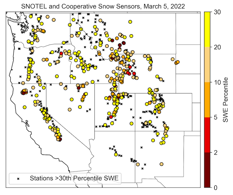
- February total precipitation was record low at over 200 Snow Telemetry (SNOTEL) sites, leading to continued expansion of snow drought conditions across the West. Fifty percent of the SNOTEL sites now have snow water equivalent (SWE) that is less than one-third of historical conditions, up from 22% in early February.
- In California, the driest January and February in state history has led to a March 1 statewide snowpack of less than 70% of average, down from 160% at the start of the new year.
- Conditions in the Klamath Basin are especially dire. This region is currently in extreme (D3) and exceptional drought (D4), according to the U.S. Drought Monitor, and the low snowpack (less than 20% of normal) heading into spring will likely further intensify drought conditions.
- Water managers in southern Idaho are getting the word out that water shortages (based on USDA Natural Resources Conservation Service estimates of adequate water supply) are expected in most basins. Most reservoir systems are not expected to fill.
- An early March atmospheric river brought several inches of precipitation to the Cascade Range in northern Oregon and Washington. However, freezing levels were higher in elevation due to the warmer air mass and therefore rain, not snow, fell at high elevations and contributed to a loss of SWE.
- Given the transition into spring, the Western U.S. is running out of time to build the snowpack before the usual peak in seasonal snow accumulation around or soon after April 1. With low reservoir carryover, the impacts of snow drought will reach into summer and beyond.
Snow Telemetry (SNOTEL) snow water equivalent (SWE) values for watersheds in the western U.S. as a percent of the USDA Natural Resources Conservation Service (NRCS) 1991–2020 median. Only stations with at least 20 years of data are included in the station averages.
The SWE percent of normal represents the current SWE at selected SNOTEL stations in or near the basin compared to the average value for those stations on this day. This map is valid as of March 7, 2022.
For an interactive version of this map, please visit NRCS.
Snow Telemetry (SNOTEL) snow water equivalent (SWE) values in watersheds in Alaska as a percent of the USDA Natural Resources Conservation Service (NRCS) 1991–2020 median. Only stations with at least 20 years of data are included in the station averages.
The SWE percent of normal represents the current SWE at selected SNOTEL stations and Snow Course sites in or near the basin compared to the average value for those sites on this day. This map is valid as of March 7, 2022.
For an interactive version of this map, please visit NRCS.
SWE Percent of NRCS 1991-2020 Median
Snow Telemetry (SNOTEL) snow water equivalent (SWE) values for watersheds in the western U.S. as a percent of the USDA Natural Resources Conservation Service (NRCS) 1991–2020 median. Only stations with at least 20 years of data are included in the station averages.
The SWE percent of normal represents the current SWE at selected SNOTEL stations in or near the basin compared to the average value for those stations on this day. This map is valid as of March 7, 2022.
For an interactive version of this map, please visit NRCS.
Snow Telemetry (SNOTEL) snow water equivalent (SWE) values in watersheds in Alaska as a percent of the USDA Natural Resources Conservation Service (NRCS) 1991–2020 median. Only stations with at least 20 years of data are included in the station averages.
The SWE percent of normal represents the current SWE at selected SNOTEL stations and Snow Course sites in or near the basin compared to the average value for those sites on this day. This map is valid as of March 7, 2022.
For an interactive version of this map, please visit NRCS.
Snow Drought Update for March 10, 2022
Most of the Western U.S. has been exceptionally dry recently, with record low February total precipitation at over 200 SNOTEL sites (minimum of 20 years of record). Exceptions include Washington, northern Idaho, northwest Montana, and a large swath of the Colorado River Basin, where snowpack is close to or above normal. There has been little snowpack accumulation, and in some cases midwinter melt, leading to a continued expansion of snow drought conditions across the West. Fifty percent of the SNOTEL sites now have snow water equivalent (SWE) that is less than the 30th percentile of historical conditions, up from 22% in early February. As of March 5, SNOTEL sites throughout California, Oregon, Nevada, Montana, Idaho, and Utah were at their record lowest or second lowest SWE. In California, the driest January and February in state history has led to a March 1 statewide snowpack of less than 70% of average, down from 160% at the start of the new year.
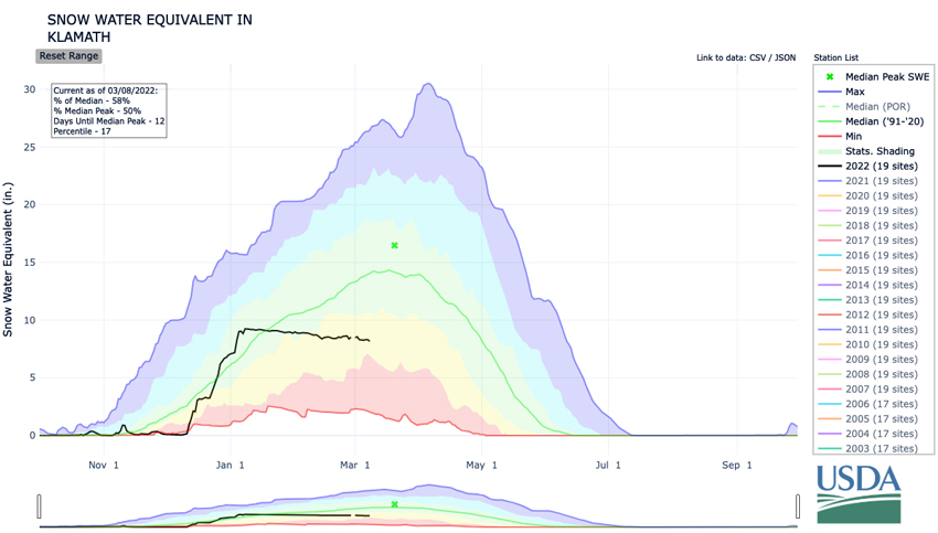
The Klamath Basin, which straddles the California-Oregon border, has particularly low snowpack for this time of year. SWE at most of the stations in the mountains of northwest California is currently less than 50% of normal, and the Klamath Basin average SWE is currently at just 58% of normal. Median SWE at three stations on the northeast border of the Klamath Basin is less than 20% of the 30-year historical record. The Klamath Basin is currently in extreme (D3) and exceptional drought (D4), according to the U.S. Drought Monitor, and the low snowpack heading into spring will likely intensify the drought conditions given that some reservoirs are near historic lows.
An atmospheric river impacted the Cascade Range of northern Oregon and Washington during the first few days of March. This storm brought several inches of precipitation. However, freezing levels were higher in elevation due to the warmer air mass, and therefore rain, not snow, occurred at high elevations. For example, at the Mt. Hood Test Site SNOTEL station (elevation 5,370 ft.; the highest SNOTEL site in the Cascade region), 2.9 inches of precipitation occurred from February 28 through March 3, but there was a net SWE loss of about one inch. SWE losses were also observed during this atmospheric river in the southern half of the Cascade Range in Washington. If this storm had been colder (i.e., lower-elevation freezing levels), the regional snowpack would have benefited significantly.
Southern Idaho has seen snowpack fail to grow since a couple of cold storms associated with atmospheric rivers boosted the snowpack in late December and early January. A number of new low precipitation records (calendar year-to-date) are being set in the mountains surrounding the Snake River basin. Particularly hard hit are the Pioneer Mountains of central Idaho, Island Park and the southern edge of the Yellowstone caldera. Records are also being set in the Independence Mountains and Bear River Range along the Utah and Nevada border. In the Big Lost and Big Wood River basins, where snowpack is 94% and 85% percent of median, seasonal forecasts are still indicating a very high chance that drought will continue for a third year. Water shortages are expected across southern Idaho. Water managers are preparing water users to utilize the drier 70% exceedance forecasts rather than the 50% exceedance forecast when planning water use. The 50% exceedance forecast assumes normal precipitation, which hasn’t been seen since January 7. Precipitation has averaged 52% for all Idaho basins from the Salmon River southward. Basins where reservoir systems appear least likely to fill and water shortages appear all but certain include the Big Wood, Snake River, Salmon Tract, Oakley, and Owyhee basins.
With the exception of a few stations in south-central Alaska that have slightly below-normal SWE (80%–85% of normal), where observations exist, they indicate that snow drought currently is not present in Alaska. The snow survey and SNOTEL sites reported that SWE in early March was above-normal across the state. Several SNOTEL sites in the mountains east of Fairbanks and one site, Indian Pass, to the southeast of Anchorage are all reporting record high SWE for early March.
Stations with SWE Below the 30th Percentile
Water Year Accumulated Snow Water Equivalent in the Klamath Basin
* Quantifying snow drought values is an ongoing research effort. Here we have used the 30th percentile as a starting point based on partner expertise. Get more information on the current definition of snow drought here.
For More Information, Please Contact:
Daniel McEvoy
Western Regional Climate Center
Daniel.McEvoy@dri.edu
Amanda Sheffield
NOAA/NIDIS California-Nevada Regional Drought Information Coordinator
Amanda.Sheffield@noaa.gov
Britt Parker
NOAA/NIDIS Pacific Northwest and Missouri River Basin Regional Drought Information Coordinator
Britt.Parker@noaa.gov
NIDIS and its partners launched this snow drought effort in 2018 to provide data, maps, and tools for monitoring snow drought and its impacts as well as communicating the status of snow drought across the United States, including Alaska. Thank you to our partners for your continued support of this effort and review of these updates. If you would like to report snow drought impacts, please use the link below. Information collected will be shared with the states affected to help us better understand the short term, long term, and cumulative impacts of snow drought to the citizens and the economy of the regions reliant on snowpack.
Report Your Snow Drought Impacts Data and Maps | Snow Drought Research and Learn | Snow Drought

