U.S. flag

An official website of the United States government

The U.S. government is closed. This site will not be updated; however, NOAA websites and social media channels necessary to protect lives and property will be maintained. To learn more, visit commerce.gov.

For the latest forecasts and critical weather information, visit weather.gov.
Document Preview
Document Date
April 5, 2017
Document Description

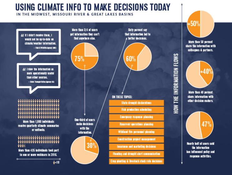
Information from regional Drought Early Warning Systems helped people make better decisions in many sectors, including construction, fish production, and agriculture. A recent survey assessed the value of drought and climate-related webinars and quarterly climate summaries produced for decision-makers in the Midwest and Missouri River Drought Early Warning Systems and in the Great Lakes Basin. The National Drought Mitigation Center at the University of Nebraska-Lincoln led the survey, which was funded by the National Integrated Drought Information System.

Document Preview
Document Date
March 21, 2017
Document Description

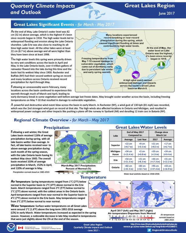
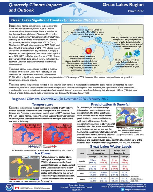
Quarterly Climate Impacts and Outlook for the Great Lakes Region for December 2016 – February 2017.  Dated March 2017. 

Document Preview
Document Date
March 21, 2017
Document Description

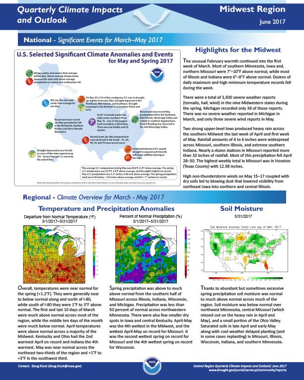
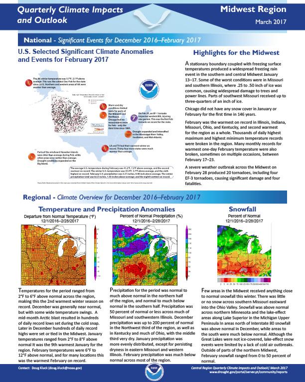
Quarterly Climate Impacts and Outlook for the Midwest Region for December 2016 – February 2017.  Dated March 2017. 

Document Preview
Document Date
March 17, 2017
Document Description

Quarterly Climate Impacts and Outlook for the Northeast Region for December 2016 – February 2017.  Dated March 2017.

Drought conditions lingered, but generally improved during winter. For details, see Climate Overview and Impacts sections.

A nor’easter dropped several inches of sleet in Maine from January 24–26. The National Weather Service said, “It was likely one of the biggest sleet storms in northern Maine during the past 75 years.” Elsewhere, strong winds and rough seas led to coastal flooding and beach erosion.

Document Preview
Document Date
February 1, 2016
Document Description

This report documents the Midwest Drought Early Warning System Kickoff Meeting, held February 9-11, 2016 in St. Louis, MO, to formally launch the Midwest DEWS. The multi-day event brought together federal, state, local, private industry and academic partners and other stakeholders for an in-depth discussion on drought and high-precipitation events in the Midwest, with attention to water, climate, land resources and emergency management. Discussions centered on improving the capacity to meet the early warning information needs of decision makers in the Midwest.

Document Preview
Document Date
February 22, 2016
Document Description

Description of the planning process behind launch of the Midwest Drought Early Warning System in February 2016.

Document Preview
Document Date
December 1, 2015
Document Description

Significant events, climate overview and regional impacts for September-November 2015 in the Midwest, with regional outlook for December 2015 – February 2016. 

Document Preview
Document Date
March 1, 2020
Document Description

Quarterly Climate Impacts and Outlook for the Midwest Region for December 2019–February 2020. Dated March 2020.

Winter temperatures averaged near normal in the northwest and above normal across the rest of the region for the season as a whole.  Precipitation was above normal for most of the Midwest and much above normal in the extreme northern areas and also the extreme southeastern areas. An area that covered much of Iowa, northern Missouri, northwestern Illinois, and the southwestern corner of Wisconsin had below-normal precipitation for the season.

Document Preview
Document Date
January 5, 2015
Document Description

From Too Much to Too Little provides an assessment of the 2012 central U.S. drought.

Ohio

Submitted by maddy.sherer on
Site Section
By Location | States
Resources Background Image
Great Falls of Tinker's Creek surrounded by trees.
Web Resources Label
Drought Resources for Ohio
Resources Section

Stay Informed: Local Drought Updates

Drought Alert Emails
Get email updates when U.S. Drought Monitor conditions change for your location or a new drought outlook is released.

Regional Drought Status Updates
NIDIS & its partners issue regional updates covering drought conditions, outlooks/forecasts, and local impacts.

Midwest Drought Email List
Get regional drought status updates right to your inbox, as well as drought news, webinars, and other events for the Midwest.

North Central U.S. Climate and Drought Summary and Outlook Webinars
This webinar series, which covers the region from the Rockies to the Great Lakes, includes a summary of past and current conditions, potential and ongoing impacts across sectors (e.g., agriculture, water resources, navigation), and outlook information.

Get Involved: Submit Local Drought Impacts

Drought in your area? Tell us how drought is impacting your community by submitting a condition monitoring report. Your submissions help us better understand how drought is affecting local conditions.

D3 Graph

U.S. Drought Monitor

The U.S. Drought Monitor (2000–present) depicts the location and intensity of drought across the country. Every Thursday, authors from NOAA, USDA, and the National Drought Mitigation Center produce a new map based on their assessments of the best available data and input from local observers. The map uses five categories: Abnormally Dry (D0), showing areas that may be going into or are coming out of drought, and four levels of drought (D1–D4). Learn more.

State Bridge
Statistics
2.8 Million

Ohio residents in areas of drought, according to the Drought Monitor

Decrease of
28.0%
since last week
1st

driest August on record (since 1895)

1.01 in.
total precipitation
Decrease of
2.46 in.
from normal
44th

wettest January—August on record (since 1895)

29.03 in.
total precipitation
Increase of
1.82 in.
from normal
Current Conditions

Ohio Current Conditions

A number of physical indicators are important for monitoring drought, such as precipitation & temperature, water supply (e.g., streamflow, reservoirs), and soil moisture. Learn more about monitoring drought.

Ohio Precipitation Conditions

Inches of Precipitation
Precipitation Shown as a Percentage of Normal Conditions
100%
Precipitation Shown as a Percentage of Normal Conditions
100%

Ohio Temperature Conditions

Maximum Temperature (°F)
60
Departure from Normal Max Temperature (°F)
0
Departure from Normal Max Temperature (°F)
0

Ohio Streamflow Conditions

Streamflow Conditions

Ohio Soil Moisture Conditions

0–100 cm Soil Moisture Percentile
70
100
Soil Moisture Anomaly
0%

Future Conditions

Outlooks & Forecasts for Ohio

Predicting drought in Ohio depends on the ability to forecast precipitation and temperature within the context of complex climate interactions. View more outlooks & forecasts.

Future Precipitation & Temperature Conditions

Predicted Inches of Precipitation
1.75
Probability of Below-Normal Precipitation
100%
Probability of Above-Normal Precipitation
100%
Probability of Below-Normal Temperatures
100%
Probability of Above-Normal Temperatures
100%

Drought Outlooks for Ohio

Drought Is Predicted To...

Main Maps
Current Ohio Drought Maps

Drought & Dryness Categories
% of OH
36.8
10.0
6.8
11.2
0.0
27.9
Drought Change Since Last Week
Dry Conditions
Wet Conditions
Dry Conditions
Wet Conditions

Experimental
Experimental
Planning & Response
Drought in the Midwest

Drought and its impacts vary from region to region—due to differences in climate. Precipitation extremes in the Midwest have a major impact on the region’s resources, economic sectors, and residents. Over the last century, precipitation trends in the Midwest have been moving towards wetter conditions and fewer droughts than the region experienced in the early 20th century. However, the Midwest has still felt adverse impacts during recent droughts, particularly in 1988 and 2012. These adverse impacts include limited barge transportation on major rivers, decreased agricultural production, challenges for municipal water supply and quality, and reduced productivity for hydropower. In 2022 and 2023, drought conditions across portions of the Mississippi River Basin caused river levels to drastically lower, which had a significant impact on the transportation of goods along the river.

An added challenge in recent years has been the tendency to transition from drought to flood and back to drought within short time spans, sometimes within a matter of months, as well as flash drought, which is a drought that intensifies rapidly.

NOAA’s National Integrated Drought Information System (NIDIS) launched the Midwest Drought Early Warning System (DEWS) in response to the 2012 drought, which highlighted the need for additional drought early warning and preparedness in the region. The Midwest DEWS is a network of regional and national partners that share information and coordinate actions to help communities in the region cope with drought.

Reach out to Molly Woloszyn, the Regional Drought Coordinator for this region, for more information, or sign up for the Midwest DEWS newsletter.

Drought Resources

Ohio State Drought Resources

Graphs Header

Historical Drought Conditions in Ohio

Drought is a normal climate pattern that has occurred in varying degrees of length, severity, and size throughout history. Below, you can look back at past drought conditions for Ohio according to 3 historical drought indices. The U.S. Drought Monitor is a weekly map that shows the location and intensity of drought across the country since 2000. The Standardized Precipitation Index (SPI) is a monthly depiction of drought based on precipitation (with data going back to 1895). And the paleoclimate data uses tree-ring reconstructions to estimate drought conditions before we had widespread instrumental records, going back to the year 0 for some parts of the U.S. View more historical conditions.

Subscribe to Ohio