Record Warmth, Rain Instead of Snow Intensifies Snow Drought Across the West
Key Points
- Snowpack is an important and large natural reservoir for many Western communities, storing water in winter as snow that typically runs off in spring. Shifts in the timing and amount of snowmelt or runoff can present challenges to drought and water planning.
- Snow cover across the West on January 4 was 141,416 square miles—the lowest January 4 snow cover in the MODIS satellite record (since 2001).
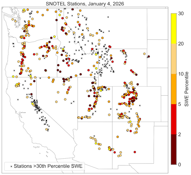
- Snow drought is most severe in Washington, Oregon, Colorado, Utah, Arizona, and New Mexico. Over 80% of all Snow Telemetry (SNOTEL) stations in each state are experiencing snow drought, defined as snow water equivalent (SWE) below the 20th percentile.
- So far in Water Year 2026 (October 1, 2025–January 4, 2026), more rain than snow has fallen in many areas. Every major river basin in the West experienced near-record or record warmth through December 2025, inhibiting the accumulation of snow.
- Precipitation in the Pacific Northwest was above-normal in December but mainly fell as rain, intensifying snow drought. In the Southwest, snow drought intensified because December precipitation was below normal.
- Snow is expected in parts of the West over the next few days, but the 2-week outlook shifts towards warm and dry conditions across the region. Snow drought will worsen if little to no new snow falls and existing snow melts.
- Water supply concerns are increasing as snow drought in parts of the Colorado River Basin and other headwaters intensifies due to warm and dry or warm and rainy conditions.
- Snow drought is impacting recreation across the West. For example, many ski areas are not able to open or have very limited terrain.
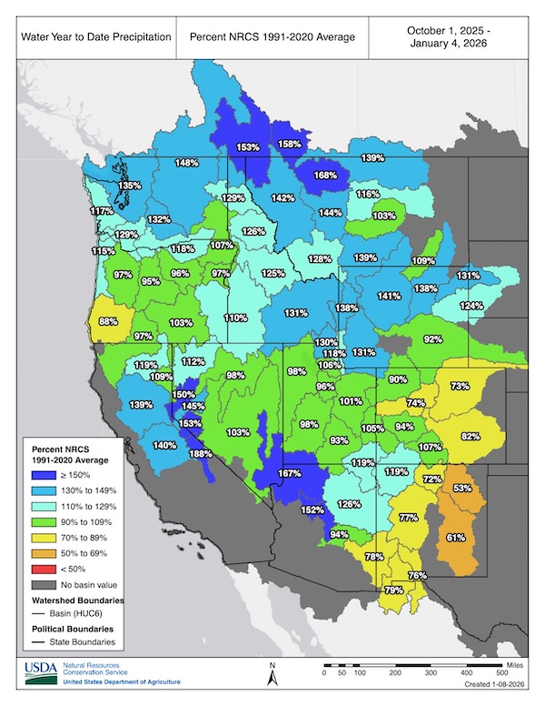
Snow water equivalent (SWE) values for watersheds in the Western U.S. as a percentage of the 1991–2020 median, based on measurements at SNOTEL weather stations. Only stations with at least 20 years of data are included in the station medians. This map is valid as of January 4, 2026. Source: USDA Natural Resources Conservation Service (NRCS).
For an interactive version of this map, please visit NRCS.
Snow water equivalent (SWE) values for watersheds in Alaska as a percentage of the 1991–2020 median, based on measurements at SNOTEL weather stations. Only stations with at least 20 years of data are included in the station median. This map is valid as of January 4, 2026. Source: USDA Natural Resources Conservation Service (NRCS).
For an interactive version of this map, please visit NRCS.
Drought is defined as the lack of precipitation over an extended period of time, usually for a season or more, that results in a water shortage. Changes in precipitation can substantially disrupt crops and livestock, influence the frequency and intensity of severe weather events, and affect the quality and quantity of water available for municipal and industrial use.
Learn MoreSnow drought is a period of abnormally low snowpack for the time of year. Snowpack typically acts as a natural reservoir, providing water throughout the drier summer months. Lack of snowpack storage, or a shift in timing of snowmelt, can be a challenge for drought planning.
Learn MorePeriods of drought can lead to inadequate water supply, threatening the health, safety, and welfare of communities. Streamflow, groundwater, reservoir, and snowpack data are key to monitoring and forecasting water supply.
Learn MoreIn a drought, lower water levels or snowpack can affect the availability of recreational activities and associated tourism, and a resulting loss of revenue can severely impact supply chains and the economy. Drought—as well as negative perceptions of drought, fire bans, or wildfires—may also result in decreased visitations, cancellations in hotel stays, a reduction in booked holidays, or reduced merchandise sales.
Learn MoreDrought is defined as the lack of precipitation over an extended period of time, usually for a season or more, that results in a water shortage. Changes in precipitation can substantially disrupt crops and livestock, influence the frequency and intensity of severe weather events, and affect the quality and quantity of water available for municipal and industrial use.
Learn MoreSnow drought is a period of abnormally low snowpack for the time of year. Snowpack typically acts as a natural reservoir, providing water throughout the drier summer months. Lack of snowpack storage, or a shift in timing of snowmelt, can be a challenge for drought planning.
Learn MorePeriods of drought can lead to inadequate water supply, threatening the health, safety, and welfare of communities. Streamflow, groundwater, reservoir, and snowpack data are key to monitoring and forecasting water supply.
Learn MoreIn a drought, lower water levels or snowpack can affect the availability of recreational activities and associated tourism, and a resulting loss of revenue can severely impact supply chains and the economy. Drought—as well as negative perceptions of drought, fire bans, or wildfires—may also result in decreased visitations, cancellations in hotel stays, a reduction in booked holidays, or reduced merchandise sales.
Learn MorePercent of Median Snow Water Equivalent
< 50% of Median
Current snow water equivalent (SWE) is less than 50% of the median SWE value for this day of the year, compared to historical conditions from 1991–2020.
50%–70% of Median
Current snow water equivalent (SWE) is between 50%–70% of the median SWE value for this day of the year, compared to historical conditions from 1991–2020.
70%–90% of Median
Current snow water equivalent (SWE) is between 70%–90% of the median SWE value for this day of the year, compared to historical conditions from 1991–2020.
90%–110% of Median
Current snow water equivalent (SWE) is between 90%–110% of the median SWE value for this day of the year, compared to historical conditions from 1991–2020.
110%–130% of Median
Current snow water equivalent (SWE) is between 110%–130% of the median SWE value for this day of the year, compared to historical conditions from 1991–2020.
130%–150% of Median
Current snow water equivalent (SWE) is between 130%–150% of the median SWE value for this day of the year, compared to historical conditions from 1991–2020.
>150% of Median
Current snow water equivalent (SWE) is greater than 150% of the median SWE value for this day of the year, compared to historical conditions from 1991–2020.
Percent of Median Snow Water Equivalent
< 50% of Median
Current snow water equivalent (SWE) is less than 50% of the median SWE value for this day of the year, compared to historical conditions from 1991–2020.
50%–70% of Median
Current snow water equivalent (SWE) is between 50%–70% of the median SWE value for this day of the year, compared to historical conditions from 1991–2020.
70%–90% of Median
Current snow water equivalent (SWE) is between 70%–90% of the median SWE value for this day of the year, compared to historical conditions from 1991–2020.
90%–110% of Median
Current snow water equivalent (SWE) is between 90%–110% of the median SWE value for this day of the year, compared to historical conditions from 1991–2020.
110%–130% of Median
Current snow water equivalent (SWE) is between 110%–130% of the median SWE value for this day of the year, compared to historical conditions from 1991–2020.
130%–150% of Median
Current snow water equivalent (SWE) is between 130%–150% of the median SWE value for this day of the year, compared to historical conditions from 1991–2020.
>150% of Median
Current snow water equivalent (SWE) is greater than 150% of the median SWE value for this day of the year, compared to historical conditions from 1991–2020.
Snow water equivalent (SWE) values for watersheds in the Western U.S. as a percentage of the 1991–2020 median, based on measurements at SNOTEL weather stations. Only stations with at least 20 years of data are included in the station medians. This map is valid as of January 4, 2026. Source: USDA Natural Resources Conservation Service (NRCS).
For an interactive version of this map, please visit NRCS.
Snow water equivalent (SWE) values for watersheds in Alaska as a percentage of the 1991–2020 median, based on measurements at SNOTEL weather stations. Only stations with at least 20 years of data are included in the station median. This map is valid as of January 4, 2026. Source: USDA Natural Resources Conservation Service (NRCS).
For an interactive version of this map, please visit NRCS.
View an updated, interactive version of this map from the USDA's Natural Resources Conservation Service. You can also view SWE data on Drought.gov.
View an updated, interactive version of this map from the USDA's Natural Resources Conservation Service. You can also view SWE data on Drought.gov.
Drought is defined as the lack of precipitation over an extended period of time, usually for a season or more, that results in a water shortage. Changes in precipitation can substantially disrupt crops and livestock, influence the frequency and intensity of severe weather events, and affect the quality and quantity of water available for municipal and industrial use.
Learn MoreSnow drought is a period of abnormally low snowpack for the time of year. Snowpack typically acts as a natural reservoir, providing water throughout the drier summer months. Lack of snowpack storage, or a shift in timing of snowmelt, can be a challenge for drought planning.
Learn MorePeriods of drought can lead to inadequate water supply, threatening the health, safety, and welfare of communities. Streamflow, groundwater, reservoir, and snowpack data are key to monitoring and forecasting water supply.
Learn MoreIn a drought, lower water levels or snowpack can affect the availability of recreational activities and associated tourism, and a resulting loss of revenue can severely impact supply chains and the economy. Drought—as well as negative perceptions of drought, fire bans, or wildfires—may also result in decreased visitations, cancellations in hotel stays, a reduction in booked holidays, or reduced merchandise sales.
Learn MoreDrought is defined as the lack of precipitation over an extended period of time, usually for a season or more, that results in a water shortage. Changes in precipitation can substantially disrupt crops and livestock, influence the frequency and intensity of severe weather events, and affect the quality and quantity of water available for municipal and industrial use.
Learn MoreSnow drought is a period of abnormally low snowpack for the time of year. Snowpack typically acts as a natural reservoir, providing water throughout the drier summer months. Lack of snowpack storage, or a shift in timing of snowmelt, can be a challenge for drought planning.
Learn MorePeriods of drought can lead to inadequate water supply, threatening the health, safety, and welfare of communities. Streamflow, groundwater, reservoir, and snowpack data are key to monitoring and forecasting water supply.
Learn MoreIn a drought, lower water levels or snowpack can affect the availability of recreational activities and associated tourism, and a resulting loss of revenue can severely impact supply chains and the economy. Drought—as well as negative perceptions of drought, fire bans, or wildfires—may also result in decreased visitations, cancellations in hotel stays, a reduction in booked holidays, or reduced merchandise sales.
Learn MoreSnow Drought Conditions Summary
This update is based on data available as of Monday, January 5, 2025 at 12:00 a.m. PT. We acknowledge that conditions are evolving.
Quantifying snow drought values is an ongoing research effort. Here, we define snow drought as snow water equivalent (SWE) at or below the 20th percentile, which is a baseline guided by partner expertise and research. Note that reporting of SWE by Snow Telemetry (SNOTEL) stations may be unavailable or delayed due to technical, weather or other issues, which may affect snow drought depiction in this update.
Current Conditions
Near-record or record warmth continued through December 2025 across every major river basin in the West, according to the Western Regional Climate Center Climate Tracker. California, Nevada, Washington, Wyoming, Colorado, Arizona, Utah, and New Mexico reported their warmest December on record.
Snow drought improved in high-elevation regions of Montana, Idaho, Wyoming, and California. Snow drought intensified elsewhere in the West, such as in the Southwest, where it has been both warm and dry. In the Pacific Northwest, precipitation continued to fall as rain instead of snow due to the record warmth.
Jump to conditions for your region:
- Colorado, Idaho, Montana, Utah, Wyoming (Rocky Mountains) Snow Conditions
- Arizona and New Mexico Snow Conditions
- Oregon and Washington Snow Conditions
- California and Nevada Snow Conditions
- Alaska Snow Conditions
A Rainy Water Year Continues for Many
Near-Record and Record Low Snow Water Equivalent at Many Stations Across the West
Rocky Mountain Snow Conditions (Colorado, Idaho, Montana, Utah, Wyoming)
Northern Rocky Mountains
- 20% of stations in Montana are in snow drought
- 49% of stations in Idaho are in snow drought
- 28% of stations in Wyoming are in snow drought
Snow conditions vary across the northern Rocky Mountains as winter continues to be quite warm. Snow drought is present in southern, western, and northern Idaho, as well as central and eastern Wyoming, where snow water equivalent (SWE) is well below median. Precipitation was much above normal across large parts of the region, with near-record warmth. These conditions allowed ample snow to fall at higher elevations, but rain fell at lower and mid-elevations.
Conditions across river basins are as follows: The Idaho Basin (60% of median SWE), the Spokane, the Lower Snake (45%), and Clearwater (69%) Basins are all below median SWE. In Wyoming, the Tongue (68% of median SWE), North Platte (79%), and Powder (85%) Basins are also below median. Elsewhere in the region, SWE is currently near-to-above median.
Precipitation often fell as rain, rather than snow, due to the warmer-than-normal temperatures. Rain-on-snow events melted low to mid-elevation snow, contributing to flooding. 28-day streamflows are high (>90th percentile) for most of the region, except southern Idaho and southwest Montana, indicating high winter runoff. With well-above-normal streamflow volume increasing reservoir storage levels, reservoir operators are making flood risk management releases in the Dworshak Reservoir (Clearwater Basin, Idaho) to make room for the upcoming spring snowmelt. The Dworshak reservoir is about 20 feet higher than the 45-year average reservoir elevation for January.
Central Rocky Mountains
- 62% of stations in Utah are in snow drought
- 85% of stations in Colorado are in snow drought
Snowpack continues to be well below the median in the central Rocky Mountains. Snow water equivalent (SWE) in Utah and Colorado generally declined over the past month due to dry and warm conditions. December temperatures in Utah and Colorado were the warmest on record. This likely contributed to low-elevation snowmelt and precipitation falling as rain, rather than snow.
Over the past 30 days, these warm temperatures limited snowfall and led to much-below-median SWE in southwestern and western Colorado and the Upper Colorado-Dirt Devil Basin of Utah,. SWE in most basins currently is less than 60% of median. Snowpack improved in northwestern Colorado and northeastern Utah, where the Yampa-White (74% of median SWE) and Lower Green (75%) Basins are below median. Conditions are near- or above-median SWE in Utah’s Lower Bear Basin and parts of the Uinta Mountains. Several days of precipitation as rain with no snowfall caused melt, reducing snow depth in some sites in the Little Cottonwood Valley of Utah.
Arizona and New Mexico Snow Conditions
- 80% of stations in Arizona are in snow drought
- 95% of stations in New Mexico are in snow drought
Snow drought worsened in Arizona and New Mexico over the past month due to dry and warm conditions. Snow water equivalent (SWE) in New Mexico basins ranges from just 0% in the Mimbres Basin to 50% in the Upper San Juan Basin. SWE in three major water supply basins in Arizona are well below median: the Little Colorado at 22% of median SWE and the Verde and Salt at 0% of median.
Snow cover data from the National Snow and Ice Data Center indicates virtually no snow is present in Arizona and New Mexico, except at a few high-elevation locations. For example, the north-central Snowslide Canyon SNOTEL station in Arizona, at 9,720 feet, currently has 8.2 inches of SWE (111% of median), while surrounding stations at ~7,000 feet have no snow. Most SWE at Snowslide Canyon accumulated in November, with little snow falling in December.
The ongoing snow drought in New Mexico is adding to water supply concerns along the San Juan River and the Rio Grande. Reservoir storage at the end of December 2025 for the Rio Grande system was the fourth lowest in 45 years. Due to deficits, water releases for agricultural needs may be reduced, and water users with surface and groundwater supplies may be forced to rely on groundwater for supply much earlier than usual.
Oregon and Washington Snow Conditions
- 81% of stations in Washington are in snow drought
- 84% of stations in Oregon are in snow drought
Snowpack continues to be well-below-normal across much of Oregon and Washington. Although several high-intensity atmospheric rivers impacted the region in December, most precipitation fell as rain in the mountains due to record warm temperatures. During the mid-December storm cycle, rain fell on snow in several basins, limiting significant improvements to snow.
In Washington, snowpack is near- to slightly-above normal at some SNOTEL stations in the Upper Columbia and North Puget Sound Basins. Snow drought is pervasive across the rest of the state. Nine SNOTEL stations across Washington have either the lowest or second lowest recorded snow water equivalent (SWE) as of January 4. Reservoirs in the Yakima Basin, which experienced three consecutive years of drought and water supply shortages, benefitted from recent rain, with the reservoir storage at 135% of normal for this time of year. However, the reservoirs are at 63% of their total capacity, which means more rain and snowmelt are needed for them to fill completely. These reservoirs must also release water year-round to meet minimum flow targets for fish, in addition to serving the agricultural water supply needs of the basin. Low snowpack is a concern for water supply in the Yakima Basin. The 28-day streamflows for most streamgages are above the 90th percentile, with many locations in the Cascade Range reporting record-high streamflow. High mid-winter streamflows are not uncommon in the Cascade Range, but excessive precipitation in the form of rain may challenge water management this winter.
Snow drought is generally worse and more pervasive in Oregon due to record warm temperatures in November and December. Of 72 SNOTEL stations in Oregon, 21 have the lowest recorded January 4 SWE , another 5 have the second lowest recorded January 4 SWE. None have above normal SWE. The Beaver Reservoir SNOTEL station in northeastern Oregon has only 56% of normal SWE for January 4, which is the highest percentage of normal of any SNOTEL station in the state.The Mt. Hood Test Site SNOTEL station, January 4 SWE is the lowest in 46 years of records. Although December was a wet month across the state, Oregon has been comparatively drier than Washington. Even with the mildly wet December, total SNOTEL water-year-to-date precipitation is only near normal for most basins in Oregon due to an extremely dry November. Water may become limited if current conditions persist throughout winter in snowmelt-dominated basins.
California and Nevada Snow Conditions
- 17% of stations in California are in snow drought
- 70% of stations in Nevada are in snow drought
Snow drought is present throughout central and northern Nevada and far northern California. Late December storms greatly improved the snowpack in the Sierra Nevada, bringing most locations to near-to-above median snow water equivalent (SWE). Record December warmth in some parts of the region, including across all of Nevada, contributed to snow disappearing at all elevations and more precipitation falling as rain than snow, reducing snowpack.
In central and northern Nevada, snowpack is much below median, with the Humboldt Basin and Black Rock Desert Basin at 44% and 27% of median SWE, respectively. Much above normal temperatures reduced snow accumulation and even led to some high elevation snowmelt (likely caused by rain falling on snow) in the Ruby Mountains and Jarbidge Mountains. Recent storms substantially improved SWE in far east-central Nevada near the Utah border, where stations in the Schell Creek Range and Snake Range are now reporting above median SWE.
In northern California, snow drought is limited to the Salmon, Trinity, and Warner Mountains in far northeastern California. The Klamath Basin (which includes many stations in southern Oregon) is at 37% of median SWE and the Upper Sacramento Basin is at 65% of median. In the Sierra Nevada, conditions improved rapidly with late December and early January snow storms. SWE in basins on the west slope of the Sierra Nevada ranges from 78% of median SWE in the north to 138% of median in the south. All of the eastern Sierra Nevada basins are reporting above median SWE, especially at the highest elevations where many of the SNOTEL stations are >130% of median. Initial storms (December 17-22) were much warmer than more recent storms. Those initial storms brought 4-8 inches of rainfall to the west slope of the northern Sierra but little to no snow except on the highest peaks, and melted the little existing snow.
Alaska Snow Conditions
58% of stations in Alaska are in snow drought
January 4 snowpack is variable across Alaska. Snow water equivalent (SWE) is currently much-below-median across South-central Alaska and near-to-above median in the Beaver Creek-Yukon River and Tanana River Basins. In South-central Alaska, the past month was extremely dry, with most SNOTEL stations reporting the driest 30-day period (ending January 4, 2026) on record. SWE is low (but not at record-low levels) due to ample snow in November. SWE at basins in Southcentral ranges from 21% of median (Susitna River) to 52% of median (Kenai Peninsula). The two SNOTEL stations on the south slope of the Brooks Range are both reporting low SWE (Coldfoot at 38% of median and Bettles Field at 58% of median). Record low-elevation snowfall was reported in the northern portion of southeast Alaska. The snow course at Petersburg Reservoir, which is at 500 feet of elevation, went from having no snow December 1, 2025 to having 4.5 inches of SWE on January 2, more than twice its median January value.
Looking Ahead
Snow is expected in parts of the West over the next few days. The National Weather Service’s forecasts for the next two weeks indicate a shift to below-normal precipitation over much of the western United States. Warmer-than-normal temperatures are likely to continue. The forecasts suggest short-term intensification of snow drought and challenges to planning, given not only a lack of snowpack, but also potential shifts in the timing and amount of snowmelt or runoff.
For More Information, Contact:
Dan McEvoy
Desert Research Institute, Western Regional Climate Center
daniel.mcevoy@dri.edu
Jason Gerlich
University of Colorado Boulder Cooperative Institute for Research in Environmental Sciences / NOAA’s National Integrated Drought Information System
jason.gerlich@noaa.gov
Amanda Sheffield
University of Colorado Boulder Cooperative Institute for Research in Environmental Sciences / NOAA’s National Integrated Drought Information System
amanda.sheffield@noaa.gov
NIDIS and its partners launched this snow drought effort in 2018 to provide data, maps, and tools for monitoring snow drought and its impacts as well as communicating the status of snow drought across the United States, including Alaska. NIDIS is an interagency program within the Climate Program Office, which is part of NOAA's Office of Oceanic and Atmospheric Research.
Thank you to our partners for your continued support of this effort and review of these updates. If you would like to report snow drought impacts, please use the link below. Information collected will be shared with the states affected to help us better understand the short term, long term, and cumulative impacts of snow drought to the citizens and the economy of the regions reliant on snowpack.
Report Your Snow Drought Impacts
Data and Maps | Snow Drought
Research and Learn | Snow Drought