
Southeast
The Southeast region generally receives substantial precipitation and is often considered water rich. However, the region is increasingly experiencing record-breaking droughts, highlighting competing water demands. Drought conditions can develop rapidly in the Southeast, especially when the lack of rain and high temperatures combine to increase evapotranspiration of water in the soils. Recurring droughts in 2009 led NIDIS to establish the Apalachicola-Chattahoochee-Flint (ACF) River Basin Drought Early Warning System (DEWS) because of the breadth and complexity of the Basin’s ongoing water management challenges. The Coastal Carolinas DEWS was established in 2012 following a series of droughts that exposed existing and emerging drought vulnerabilities that are particular to coastal regions.
Recognizing a need to improve drought early warning across the full geographic footprint of the Southeast, and in response to requests from regional stakeholders, NIDIS launched a newly expanded Southeast DEWS in 2020. This Southeast DEWS will build on the partnerships and successes from the ACF River Basin and Coastal Carolinas DEWS, while replacing these two DEWS with a larger geographic footprint that allows for enhanced information sharing across this unique region. The Southeast DEWS is a collaborative federal, regional, state, and local interagency effort to improve drought early warning capacity and build long-term drought resilience throughout the region.
Primary contact: Elliot Wickham, Regional Drought Information Coordinator

This report was developed to improve the monitoring, communication, and response to drought in the Southeastern United States, with a specific focus on flash drought. The 2019 flash drought exposed critical gaps in early warning and monitoring systems, sparking conversations that continued during the 2022 Southeast Drought Early Warning System (DEWS) Regional Meeting. The report provides a retrospective analysis of the 2023 fall drought, including its development, sectoral impacts, and lessons learned for future resilience.
Regional Activities
The following table highlights activities in the Southeast that are ongoing efforts related to drought, involve multiple partners, serve as a unique way to address regional drought needs, and are related to at least one of the components of drought early warning. Please contact Elliot Wickham (elliot.wickham@noaa.gov) for more information about the table or to inquire about getting an activity added to the list.
DEWS Component Legend
On August 9–10, 2022, NIDIS hosted the Southeast Drought Early Warning System (DEWS) Partners Dialogue in Atlanta, Georgia. This regional gathering brought together partners for the first time…
2022
2022
The Coastal Salinity Index (CSI) was developed as a way to characterize coastal drought by monitoring the freshwater-saltwater interface. The tool is intended to improve understanding of the…
2016
2020
The purpose of this project is to provide organic soil moisture data and information to aid coastal zone fire risk monitoring and management. Current and archived data from these stations are…
2017
2021
To improve access and usability of drought and water information across the Mississippi River Basin, NOAA, in partnership with the U.S. Army Corps of Engineers, is developing a…
2024
2025
This project engages with citizen scientists and the Community Collaborative Rain, Hail, and Snow (CoCoRaHS) Network to promote drought impacts reporting. Observers provide weekly “condition…
2017
2020
Observation + Monitoring
When monitoring drought, it is important to look at data across the spectrum—from the atmosphere, land surface, and water availability below the surface. The list of data and maps below has been customized for the Southeast, and provides a snapshot of conditions across that spectrum—including precipitation and temperature departure data, streamflow, soil moisture, groundwater, and various derived indices for monitoring drought in the region. Monitoring for the impact of drought is also important, and resources to submit conditions and/or impacts and view conditions are provided.
Regional Data and Maps
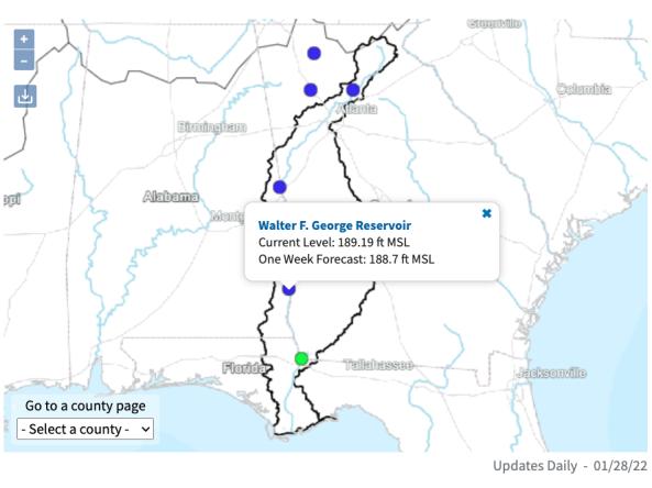
The ACF River Basin Drought and Water Dashboard is a web-based application that allows decision makers to view real-time information on the ACF River Basin all in one place.
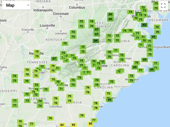
A one-stop shop tool that places recent temperature and precipitation conditions in both a historical and geographical perspective across the Southeast.
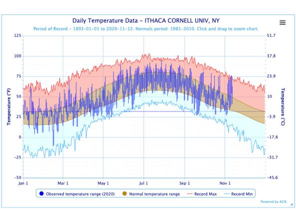
The Regional Climate Centers (RCC) Applied Climate Information System (ACIS) offers interactive temperature and precipitation charts with single- or multi-station capabilities.
The National Water Dashboard is an interactive map viewer that shows provisional real-time water data from more than 13,000 USGS observation stations in context with weather-related data
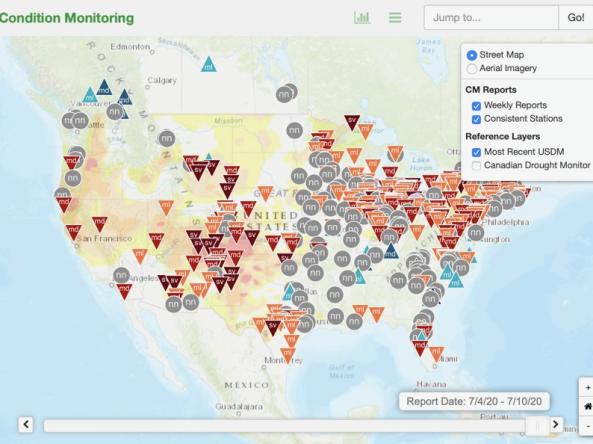
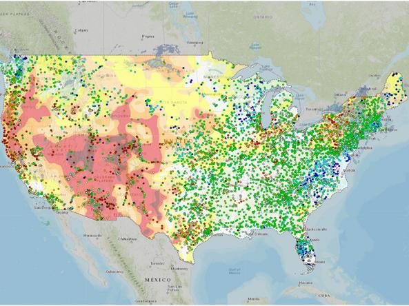
This condition monitoring map is a tool intended to depict local, community-level conditions and how recent weather and climate events have affected those communities.
The Lawn and Garden Moisture Index measures the capacity of current soil moisture to sustain healthy lawns and gardens in the Southeast U.S.
Planning + Preparedness
There is little that can be done to influence the weather patterns that cause drought, but preparatory actions and policies can help communities cope with drought impacts. Drought planning can ensure continuity of public services and quality of life. Drought planning can be done at the local and/or state level, or integrated into existing plans (e.g., hazard mitigation planning, land-use planning).
Regional Drought Planning Resources


Prediction + Forecasting
When will drought affect me? How long could it last? This section includes resources for drought prediction and forecasting on what could be ahead, including the short-term (e.g., 8-14 day forecast), seasonal to subseasonal (e.g., monthly) and future climate projections (e.g., mid-century). The appropriate time scale will depend upon how this information is being used (e.g., drought response, mitigation management action, long-term planning). Weather and climate prediction is an evolving science, as researchers continue to find ways to improve models and forecasting capabilities at various time scales.
Regional Forecasts and Outlooks
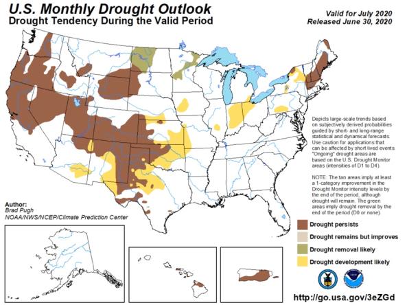
The monthly and seasonal (3-month) outlook for drought tendency from the Climate Prediction Center (CPC), which depicts large-scale trends based on subjectively derived probabilities guided by shor
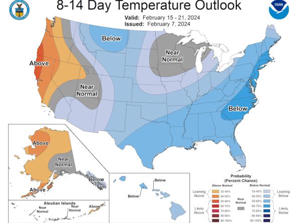
The Climate Prediction Center (CPC) produces temperature and precipitation outlooks for the U.S., including 6-10 day, 8-14 day, monthly, and seasonal outlooks.
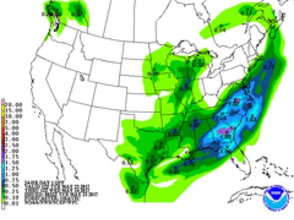
NWS WPC produces Quantitative Precipitation Forecasts (QPFs) that depict the amount of liquid precipitation expected to fall in a defined period of time.
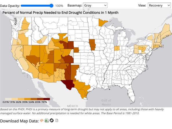
NCEI provides precipitation data that can be used to show probability or the amount of precipitation to ameliorate or end a drought at different monthly scales.
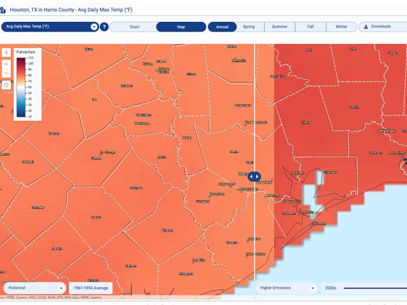
The Climate Explorer offers graphs and maps of observed and projected temperature, precipitation, and related climate variables for every county in the contiguous United States, helping people asse
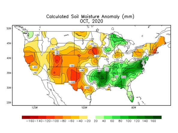
Soil moisture conditions at the daily and monthly scales depicting total soil moisture, percentiles and anomalies, as well as monthly and seasonal change.
Communication + Outreach
An important component for drought early warning is communicating this information to stakeholders across the Southeast who need this information to make more informed decisions. In addition to state-level information, there are various ways drought information is shared and communicated at a regional level across the Southeast. This includes a Southeast Monthly Climate Webinar series, a quarterly climate report, and the Southeast DEWS email list. NIDIS is also working with regional partners to develop an "ACF River Basin Drought Dashboard" to improve access and communication of drought information across this watershed.
If you are interested in joining the Southeast DEWS listserv to share drought-related information across the Southeast, please email Elliot Wickham (elliot.wickham@noaa.gov).
Regional Communications Documents


Research + Applications
Research to better understand drought in the Southeast and its development, persistence, improvement, and interaction with other hazards is critical to providing timely and reliable information, products, and services in support of early warning. This page highlights research projects that are studying drought in the Southeast region, with support from NIDIS.