West Braces for Critical Water Shortages After Unprecedented Snow Drought
Key Points
- Snowpack, the western U.S.’s largest non-man made reservoir, is already gone in many places. Significant hydrological drought impacts (low water supply) are already occurring and will continue through summer across much of the West. Compounding these impacts, the West continues to experience long-term drought. Drought conditions can be expected to deteriorate, and impacts to become more pronounced.
- April and May snowfall in some areas did not offset seasonal snow deficits, but increased soil moisture and slowed high-elevation snowmelt, which may slow drought deterioration and temporarily mitigate early season wildfire risk. Snow did not fall in all states.
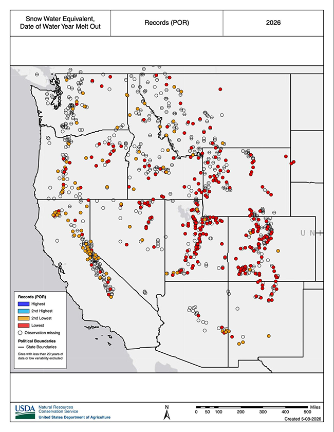
- This year’s peak snowpack will be the new benchmark low for Wyoming, Utah, Colorado, and New Mexico; there are no comparable years. In these states, snow water equivalent (SWE) around April 1, the usual peak date, was 32- 53% lower than the previous record low during the SNOTEL era. In Idaho, record warm temperatures pushed snow to only the high elevations, leaving the state with no historical comparison.
- Earlier-than-normal meltout (snow no longer present) occurred across the Western U.S., with many SNOTEL locations setting a new earliest or second earliest meltout date on record. Water supply forecasts in many watersheds are still forecasted to approach historic lows or at historic lows.
- In Oregon, 62 of 73 forecast points are approaching or at historic lows.
- In Utah, peak flows occurred and concluded in many streams before the spring runoff season even started.
- As the West enters summer, evaporative demand (thirst of the atmosphere) and water demands will increase. This will further strain and reduce water supplies. Current outlooks favor-warmer-than-normal normal temperatures. Any relief will depend on late spring storms, along with the level of activity and geographic extent of the monsoon season.
Snow water equivalent (SWE) values for watersheds in the Western U.S. as a percentage of the 1991–2020 median, based on measurements at SNOTEL weather stations. Only stations with at least 20 years of data are included in the basin median. This map is valid as of May 14, 2026.
For an interactive version of this map, please visit the USDA Natural Resources Conservation Service.
Snow water equivalent (SWE) values for watersheds in Alaska as a percentage of the 1991–2020 median, based on measurements at SNOTEL weather stations and snow courses. Only stations with at least 20 years of data are included in the basin median. This map is valid as of May 1, 2026.
For an interactive version of this map, please visit the USDA Natural Resources Conservation Service.
Drought is defined as the lack of precipitation over an extended period of time, usually for a season or more, that results in a water shortage. Changes in precipitation can substantially disrupt crops and livestock, influence the frequency and intensity of severe weather events, and affect the quality and quantity of water available for municipal and industrial use.
Learn MoreSnow drought is a period of abnormally low snowpack for the time of year. Snowpack typically acts as a natural reservoir, providing water throughout the drier summer months. Lack of snowpack storage, or a shift in timing of snowmelt, can be a challenge for drought planning.
Learn MorePeriods of drought can lead to inadequate water supply, threatening the health, safety, and welfare of communities. Streamflow, groundwater, reservoir, and snowpack data are key to monitoring and forecasting water supply.
Learn MoreIn a drought, lower water levels or snowpack can affect the availability of recreational activities and associated tourism, and a resulting loss of revenue can severely impact supply chains and the economy. Drought—as well as negative perceptions of drought, fire bans, or wildfires—may also result in decreased visitations, cancellations in hotel stays, a reduction in booked holidays, or reduced merchandise sales.
Learn MoreDrought is defined as the lack of precipitation over an extended period of time, usually for a season or more, that results in a water shortage. Changes in precipitation can substantially disrupt crops and livestock, influence the frequency and intensity of severe weather events, and affect the quality and quantity of water available for municipal and industrial use.
Learn MoreSnow drought is a period of abnormally low snowpack for the time of year. Snowpack typically acts as a natural reservoir, providing water throughout the drier summer months. Lack of snowpack storage, or a shift in timing of snowmelt, can be a challenge for drought planning.
Learn MorePeriods of drought can lead to inadequate water supply, threatening the health, safety, and welfare of communities. Streamflow, groundwater, reservoir, and snowpack data are key to monitoring and forecasting water supply.
Learn MoreIn a drought, lower water levels or snowpack can affect the availability of recreational activities and associated tourism, and a resulting loss of revenue can severely impact supply chains and the economy. Drought—as well as negative perceptions of drought, fire bans, or wildfires—may also result in decreased visitations, cancellations in hotel stays, a reduction in booked holidays, or reduced merchandise sales.
Learn MorePercent of Median Snow Water Equivalent
< 50% of Median
Current snow water equivalent (SWE) is less than 50% of the median SWE value for this day of the year, compared to historical conditions from 1991–2020.
50%–70% of Median
Current snow water equivalent (SWE) is between 50%–70% of the median SWE value for this day of the year, compared to historical conditions from 1991–2020.
70%–90% of Median
Current snow water equivalent (SWE) is between 70%–90% of the median SWE value for this day of the year, compared to historical conditions from 1991–2020.
90%–110% of Median
Current snow water equivalent (SWE) is between 90%–110% of the median SWE value for this day of the year, compared to historical conditions from 1991–2020.
110%–130% of Median
Current snow water equivalent (SWE) is between 110%–130% of the median SWE value for this day of the year, compared to historical conditions from 1991–2020.
130%–150% of Median
Current snow water equivalent (SWE) is between 130%–150% of the median SWE value for this day of the year, compared to historical conditions from 1991–2020.
>150% of Median
Current snow water equivalent (SWE) is greater than 150% of the median SWE value for this day of the year, compared to historical conditions from 1991–2020.
Percent of Median Snow Water Equivalent
< 50% of Median
Current snow water equivalent (SWE) is less than 50% of the median SWE value for this day of the year, compared to historical conditions from 1991–2020.
50%–70% of Median
Current snow water equivalent (SWE) is between 50%–70% of the median SWE value for this day of the year, compared to historical conditions from 1991–2020.
70%–90% of Median
Current snow water equivalent (SWE) is between 70%–90% of the median SWE value for this day of the year, compared to historical conditions from 1991–2020.
90%–110% of Median
Current snow water equivalent (SWE) is between 90%–110% of the median SWE value for this day of the year, compared to historical conditions from 1991–2020.
110%–130% of Median
Current snow water equivalent (SWE) is between 110%–130% of the median SWE value for this day of the year, compared to historical conditions from 1991–2020.
130%–150% of Median
Current snow water equivalent (SWE) is between 130%–150% of the median SWE value for this day of the year, compared to historical conditions from 1991–2020.
>150% of Median
Current snow water equivalent (SWE) is greater than 150% of the median SWE value for this day of the year, compared to historical conditions from 1991–2020.
Snow water equivalent (SWE) values for watersheds in the Western U.S. as a percentage of the 1991–2020 median, based on measurements at SNOTEL weather stations. Only stations with at least 20 years of data are included in the basin median. This map is valid as of May 14, 2026.
For an interactive version of this map, please visit the USDA Natural Resources Conservation Service.
Snow water equivalent (SWE) values for watersheds in Alaska as a percentage of the 1991–2020 median, based on measurements at SNOTEL weather stations and snow courses. Only stations with at least 20 years of data are included in the basin median. This map is valid as of May 1, 2026.
For an interactive version of this map, please visit the USDA Natural Resources Conservation Service.
View an updated, interactive version of this map from the USDA's Natural Resources Conservation Service. You can also view SWE data on Drought.gov.
View an updated, interactive version of this map from the USDA's Natural Resources Conservation Service. You can also view SWE data on Drought.gov.
Drought is defined as the lack of precipitation over an extended period of time, usually for a season or more, that results in a water shortage. Changes in precipitation can substantially disrupt crops and livestock, influence the frequency and intensity of severe weather events, and affect the quality and quantity of water available for municipal and industrial use.
Learn MoreSnow drought is a period of abnormally low snowpack for the time of year. Snowpack typically acts as a natural reservoir, providing water throughout the drier summer months. Lack of snowpack storage, or a shift in timing of snowmelt, can be a challenge for drought planning.
Learn MorePeriods of drought can lead to inadequate water supply, threatening the health, safety, and welfare of communities. Streamflow, groundwater, reservoir, and snowpack data are key to monitoring and forecasting water supply.
Learn MoreIn a drought, lower water levels or snowpack can affect the availability of recreational activities and associated tourism, and a resulting loss of revenue can severely impact supply chains and the economy. Drought—as well as negative perceptions of drought, fire bans, or wildfires—may also result in decreased visitations, cancellations in hotel stays, a reduction in booked holidays, or reduced merchandise sales.
Learn MoreDrought is defined as the lack of precipitation over an extended period of time, usually for a season or more, that results in a water shortage. Changes in precipitation can substantially disrupt crops and livestock, influence the frequency and intensity of severe weather events, and affect the quality and quantity of water available for municipal and industrial use.
Learn MoreSnow drought is a period of abnormally low snowpack for the time of year. Snowpack typically acts as a natural reservoir, providing water throughout the drier summer months. Lack of snowpack storage, or a shift in timing of snowmelt, can be a challenge for drought planning.
Learn MorePeriods of drought can lead to inadequate water supply, threatening the health, safety, and welfare of communities. Streamflow, groundwater, reservoir, and snowpack data are key to monitoring and forecasting water supply.
Learn MoreIn a drought, lower water levels or snowpack can affect the availability of recreational activities and associated tourism, and a resulting loss of revenue can severely impact supply chains and the economy. Drought—as well as negative perceptions of drought, fire bans, or wildfires—may also result in decreased visitations, cancellations in hotel stays, a reduction in booked holidays, or reduced merchandise sales.
Learn MoreSnow Drought Conditions Summary
This update is based on data available as of Monday, May 11, 2026 at 12:00 a.m. PT. We acknowledge conditions are evolving.
Quantifying snow drought values is an ongoing research effort. Here, we define snow drought as snow water equivalent (SWE) at or below the 20th percentile, which is a baseline guided by partner expertise and research. Note that reporting of SWE by Snow Telemetry (SNOTEL) stations may be unavailable or delayed due to technical, weather or other issues, which may affect snow drought depiction in this update.
Current Conditions
The unprecedented heat wave and rapid snowmelt in March made recovery from the snow drought nearly impossible, despite the April and May snow for some. The April and May storms slowed snowmelt in the high elevations where little snowpack remains and brought rain to the lower elevations, increasing soil moisture. These conditions will likely slow further drought deterioration and mitigate immediate wildfire risk. However, not all states saw this precipitation. Outlooks continue to favor an early start to the wildfire season in some areas of the West.
This water year continues to be the warmest on record (since 1895) in California, Nevada, Utah, Arizona, Colorado, Utah, New Mexico, Wyoming, and Montana; the second warmest in Oregon and Idaho; and the fourth warmest in Washington. The average temperature over the last 5 years was the warmest on record in Wyoming, Arizona, Colorado, Idaho, Montana, Nevada, Utah, and Washington. In California and Oregon, the last 5 years were the third warmest 5-year period on record. Many states are experiencing long-term drought, compounding the impacts from this year's snow drought. Record low water supply are forecasted in many locations, reflecting the impacts of this year's snow drought, long term drought, and record warmth.
This year's western snow drought is considerably worse than significant snow droughts of the past for many states. Even for states where there is precedence, anticipating impacts or drawing comparisons to previous significant snow droughts is challenging given increasing demands on western water supply and multiyear droughts. In Washington, snowpack in 2026 was greater than its record low, 2015, and similar to that in 2001. However, Washington is in its fourth consecutive year of drought, and a drought emergency was declared in all previous years with similarly low snowpack. This year’s peak snowpack will be the lowest on record for Wyoming, Utah, Colorado, and New Mexico. This year will represent the new benchmark low. In these states, snowpack around April 1, the usual peak date, was 32- 53% lower than the previous record low in the SNOTEL record. Idaho also experienced a new record low snow season. In Idaho, warm temperatures melted snow at middle and lower elevations, and no previous years compare to this condition for the state.
Given that snow droughts often precede hydrological drought (when low water supply becomes evident in the water system), significant hydrological drought impacts are already and will continue to impact much of the West.
Jump to conditions for your region:
- Colorado, Idaho, Montana, Utah, Wyoming (Rocky Mountains) Snow Conditions
- Arizona and New Mexico Snow Conditions
- Oregon and Washington Snow Conditions
- California and Nevada Snow Conditions
- Alaska Snow Conditions
Widespread Early Snowmelt Across West
Rocky Mountain Snow Conditions (Colorado, Idaho, Montana, Utah, Wyoming)
Northern Rocky Mountains
The remaining high elevation snowpack is much below normal, with nearly all basins in the region at 60% of median snow water equivalent (SWE) or less. In Idaho, only about one-third of SNOTEL stations have snow remaining. In Montana and Wyoming, about half of the stations have snow remaining. Among the stations that already melted out, snow disappeared an average of 29 days early in Idaho, 28 in Montana, and 35 in Wyoming. The season (October-April) was characterized by near-to-above average precipitation and well-above-normal temperatures, with Wyoming and Montana reporting record warmth. Peak SWE occurred much earlier than usual and was about 70% of median in Idaho and Wyoming and about 80% of median in Montana. Idaho and Wyoming reported their lowest April 1 SWE values in the SNOTEL record.
Montana
On July 1, 2021, Montana Governor Greg Gianforte declared a statewide drought emergency for all 56 counties due to the rapid expansion and deterioration of drought conditions. This emergency is still in effect as of May 14, 2026, as state drought emergencies in Montana continue until the hazard resolves. Some areas of Montana have continuously been in Severe Drought (D2) since June 16, 2020. For example, Glacier County has experienced drought conditions nearly continuously since spring 2021. April 1 snowpack in Montana in 2026 was the third lowest on record. On May 8, 2026, Montana placed a call under the Yellowstone River Compact, placing water users on Wyoming’s Tongue River under priority administration. The call cited drought conditions over the past year and historically low winter snowpack and streamflows. This call impacts junior diversions in the Tongue River Basin, who are required to curtail water use to ensure that more senior water rights holders receive their allocations. A formal drought declaration allows for fast-tracking disaster relief, access to state emergency funds, logistical and regulatory relief, and streamlined water management and coordination.
Idaho
On April 13, 2026, Idaho Governor Brad Little and the Idaho Department of Water Resources (IDWR) declared a statewide drought emergency for all 44 counties due to record-breaking warmth, historic snowpack deficit, and projected water shortages. April 1 snowpack in Idaho was the lowest on record, and the only winter warmer than 2025-2026 was during 1933-1934. The last statewide drought emergency was issued in 2001. Six of the past 10 years have seen county drought emergencies, in parts of the state. For example, with the exception of 2023, drought emergencies have been declared in Custer and Butte counties every year since 2020. According to the state of Idaho, parts of the state have been in drought since 2019. A formal drought declaration allows for temporary changes in certain characteristics of existing water rights and exchanges of water rights where they do not harm existing water rights.
Wyoming
On February 5, 2026, the Wyoming State Engineer’s Office implemented priority administration for the North Platte River and its tributaries to help meet reservoir fill demands. Citing low snowpack and prolonged drought, the office curtailed water rights upstream of Pathfinder Reservoir with priority dates after December 6, 1904, and water rights between Pathfinder Dam and Guernsey Reservoir, with priority dates after April 20, 1923. On April 16, the State Engineer’s Office issued a memo that cited drought conditions and provided any water supply may be used for fighting wildfires in an emergency. As part of the Drought Response Operations Agreement, the Bureau of Reclamation began releases from Flaming Gorge Reservoir on April 23. On May 1, 2026, the state lifted priority administration on the North Platte River but limited irrigation between Pathfinder and Guernsey. On May 5, 2026, citing “very dry conditions,” the State Engineer’s Office issued an emergency declaration allowing more flexibility for livestock water rights. On May 8, 2026, Montana placed a call under the Yellowstone River Compact, placing water users on Wyoming’s Tongue River under priority administration. The call cited drought conditions over the past year, with historically low winter snowpack and streamflow. Other than a brief period in 2023, drought conditions have been present in some parts of Wyoming since May 2020.
Central Rocky Mountains
Much of the snow is gone at SNOTEL stations in Utah and Colorado, with snow remaining at only 12% and 37% of stations in the two states, respectively. At stations where snow has disappeared, the melt out occurred an average of 40 days early. Snow water equivalent (SWE) at most of the remaining stations is at 20% of median or less. Storms in April slowed high elevation snowmelt, but were far from sufficient for the region to recover from considerable seasonal SWE deficits. An early May snowstorm in Colorado brought beneficial moisture to parts of the state, but again, did not alleviate the SWE deficits and water supply concerns. Record low streamflow volumes are forecast for the Yampa River (28% of average) and the Colorado River at Lake Powell (13% of average). Temperatures in October-April in Utah and Colorado were the highest on record, but, in contrast to the northern Rocky Mountains, seasonal precipitation across the region was generally much below normal. Water year precipitation totals were below the 15th percentile for many SNOTEL stations in central Utah and central and northern Colorado.
Utah
On May 7, 2026, the Utah Drought Response Committee formally recommended Utah Governor Spencer Cox issue a drought emergency declaration for all 29 counties in the state. The recommendation cited record low snowpack, water supply concerns, and statewide drought. Formal drought declarations also were issued for parts or all of the state in 2021, 2022, and 2025. Drought has impacted southern Utah for 8 of the last 10 years. A formal drought emergency declaration allows the state to activate resources, support agriculture, and coordinate water restrictions.
Colorado
On March 16, 2026, acting on recommendations from the state’s Water Conditions Monitoring Committee, Governor Jared Polis activated Phase 2 of the state’s Drought Response Plan and the state's Drought Task Force. The actions followed the warmest start to the water year in the Colorado Climate Center’s 131-year record, and statewide snow water equivalent among the lowest in more than four decades of records. The last time the Drought Task Force was activated was in 2020. During every year since 2020, portions of the South Platte River and Rio Grande River have required priority calls to curtail water use to ensure that senior water rights holders receive their legal share. The Drought Task Force identifies critical impact areas to coordinate state-level support and resources for affected Colorado communities.
Arizona and New Mexico Snow Conditions
Snow has melted out from all SNOTEL stations in Arizona and all but one in New Mexico. The average melt out date was 44 days early in New Mexico and 35 days early in Arizona. Overall, it was an extremely short snow season for the region, with snow confined to the highest elevations for much of the season. Temperatures in both states reached record highs from October-April, but seasonal precipitation patterns varied across the region. Water year precipitation was near-to-above normal in the central Arizona mountains, below normal in south-central Arizona and New Mexico, and much below normal in the southern extent of the Rocky Mountains, with several SNOTEL stations in the Sangre de Cristo Mountains reporting the lowest or second lowest totals on record.
Arizona
In 2025, Arizona operated under Tier 1 reductions in Colorado River Water Supply and is still operating under this structure. These reductions are a result of less available water in the Colorado River, impacting central Arizona agricultural users. These reductions represent a 512,000 acre-foot reduction in water, with most reductions being taken by the Central Arizona Project water users.
New Mexico
Several years of extreme drought and the earliest snowmelt on record are challenging water users of the Rio Grande River. The Middle Rio Grande Conservancy District began staggered irrigation operations in late March with natural flow of the Rio Grande. The Carlsbad Irrigation District began releases for irrigation on March 22 and has allocated only 2.5 acre-feet per acre to farmers.
Oregon and Washington Snow Conditions
As of May 12, snow is present at only about 10% of SNOTEL stations in Oregon and 40% in Washington. Snow in both states melted much earlier than usual, with average melt out occurring 42 days early in Oregon and 26 days early in Washington. A trace of snow remains at SNOTEL stations in the Oregon Cascade Range, and stations in the Lower Snake Basin in northeast Oregon are at 14% of median snow water equivalent (SWE). Except for a few sites in the northern Cascade Range, most SNOTEL stations in Washington with remaining snow report less than 50% of median SWE. In Washington, 24 of 46 streamflow forecast points for April-September predictions are forecast to approach historic lows (below the 15th percentile). In Oregon, 62 of 73 streamflow forecast points for April-September predictions are approaching historic lows (below the 15th percentile).
Temperature patterns were similar in Oregon and Washington this season. The period from October through April was the second warmest on record in Oregon and fourth warmest in Washington (since 1895). Water year precipitation in the Cascade Range near the Oregon-Washington border was near-to-above normal. The central and southern Cascade Range in Oregon was much drier, with many stations below the 15th percentile.The central and northern Washington Cascade Range was much wetter, with many stations above the 80th percentile for precipitation. Total precipitation for Oregon was ranked the 31st driest for October-April at 84.9% of normal. Over the last 12 months (May 2025-April 2026), Oregon experienced its 13th driest such period since 1895; the 12 month period of April 2025-March 2026 was its 6th driest. The lack of precipitation and warmer temperatures contributed to snow drought in much of Oregon.
Washington
On April 8, 2026, the Washington Department of Ecology issued a drought declaration for all watersheds in the state due to sparse snowpack and multiple years of precipitation deficits. The state has experienced low snowpack all winter and projects that water supplies will fall far short of the state’s summer demand. This is the state’s fourth consecutive drought declaration, a record under the drought framework established in 1989. Drought has been declared in part or all of the state during seven of the past ten years. Yakima County received a state drought declaration or drought advisory every year since 2021. The last year during which no declaration or advisory was issued was 2020. A formal drought declaration allows for emergency drought relief in the form of expediting processing of applications for temporary emergency drought permits and temporary transfers of water rights, and funding assistance for tribes and public entities such as municipalities, irrigation districts, and public utility districts. More information on resources can be found at Washington Department of Ecology Drought Response Resources.
Oregon
In February, counties in Oregon began requesting drought declarations given historically warm temperatures; below-normal precipitation, streamflows, and snowpack; and drier than normal soil moisture conditions. As of May 14, 12 of Oregon’s 36 counties have approved emergency drought declarations, and 3 have pending declarations. A county drought declaration in Oregon allows for expedited water rights, state coordination, and resource access. Counties under a drought declaration approved by the Oregon Drought Readiness Council and Governor Tina Kotek are Coos, Klamath, Wheeler, Crook, Grant, Jackson, Jefferson, Morrow, Wallowa, Baker, Deschutes, and Umatillia. Counties with pending declarations are Douglas, Harney, and Gilliam. Drought was declared in some counties in Oregon in seven of the past 10 years. Jefferson County has received a drought declaration every year since 2020.
California and Nevada Snow Conditions
Snow remains on about 40% of snow pillows in California (SNOTEL and California Department of Water Resources stations) and just four SNOTEL stations in Nevada (all in the eastern Sierra Nevada). At other stations, melt out occurred an average of 43 days early in California and 37 days early in Nevada. High elevation stations (above 8,000 feet) in the Sierra Nevada received appreciable snow in April, and at some stations, net snow water equivalent (SWE) increased over the month. The precipitation improved the meager snowpack but did not counteract the seasonal deficits or the lack of snow at lower elevations due to extremely warm temperatures.
California and Nevada both experienced their warmest October-April on record. The extremely low snowpack and snow drought conditions manifested quite differently in the two states due to much different precipitation patterns. In the Sierra Nevada, water year precipitation was near normal to slightly above normal. Conditions were much drier in northeast Nevada, where many SNOTEL stations in the Ruby Mountains and mountains north of Interstate 80 reported water year precipitation totals less than the 10th percentile. The warm and wet snow drought in the Sierra Nevada and rapid early melt in March led to much-above-normal seasonal runoff, whereas a warm and dry snow drought led to less than 50% of normal runoff in Nevada’s Humboldt Basin. Both regions are expected to have below-normal warm season runoff. The Sierra Nevada water year total runoff is expected to be closer to normal due to the extreme shift in timing, with a greater portion of total runoff coming earlier in the season and well-below normal streamflow in the warm season. Water year total runoff forecasts on the Humboldt River in Nevada are less than 20% of median at most forecast points.
California
The current State Water Project allocation for 2026 is 45%. For the Central Valley Project, the U.S. Bureau of Reclamation increased in-Delta contractors' share from 15% to 20% of their contract total in late March, and in-Delta municipal and industrial contractors remain at 100%. As of May 19, south-of-Delta irrigation water service and repayment contractors were increased from 20% to 25% of their contract total while municipal and industrial water service and repayment contractors were increased from 70% to 75%.
Nevada
Currently 10 counties in Nevada are in drought Watch Stage based on the May 5, 2026 U.S. Drought Monitor. Defined in the Nevada State Drought Response Plan (2012), the drought Watch Stage means 50% or more of their area is in drought (D1, Moderate Drought). The state does not currently have plans to curtail water in the Humboldt River Basin, which is the state’s largest river basin.
Alaska Snow Conditions
Early May snow course and SNOTEL observations indicate below-normal SWE for much of Southcentral Alaska and much-above-normal SWE in the Interior. Nearly all of Alaska experienced a colder-than-normal water year. It was quite dry for the Kenai Peninsula and coastal area of Southcentral, leading to a much-below-normal snow season at many SNOTEL stations. Conversely, it was very wet in the Interior with many locations around Fairbanks receiving more than 150% of normal water year precipitation. No current state drought responses are ongoing in Alaska.
For More Information, Contact:
Dan McEvoy
Desert Research Institute, Western Regional Climate Center
daniel.mcevoy@dri.edu
Jason Gerlich
University of Colorado Boulder Cooperative Institute for Research in Environmental Sciences / NOAA’s National Integrated Drought Information System
jason.gerlich@noaa.gov
Tony Bergantino
Wyoming State Climate Office, University of Wyoming
antonius@uwyo.edu
Amanda Sheffield
University of Colorado Boulder Cooperative Institute for Research in Environmental Sciences / NOAA’s National Integrated Drought Information System
amanda.sheffield@noaa.gov
NIDIS and its partners launched this snow drought effort in 2018 to provide data, maps, and tools for monitoring snow drought and its impacts as well as communicating the status of snow drought across the United States, including Alaska. NIDIS is an interagency program within the Climate Program Office, which is part of NOAA's Office of Oceanic and Atmospheric Research.
Thank you to our partners for your continued support of this effort and review of these updates. If you would like to report snow drought impacts, please use the link below. Information collected will be shared with the states affected to help us better understand the short- term, long- term, and cumulative impacts of snow drought to the citizens and the economy of the regions reliant on snowpack.
Report Your Snow Drought Impacts
Data and Maps | Snow Drought
Research and Learn | Snow Drought